Larrabee, Wisconsin
Submit your own pictures of this town and show them to the world
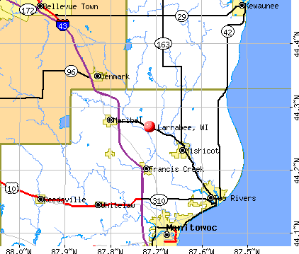
- OSM Map
- General Map
- Google Map
- MSN Map
Population change since 2000: +6.1%
 |
| Males: 717 | |
| Females: 664 |
| Median resident age: | 44.6 years |
| Wisconsin median age: | 42.6 years |
Zip codes: 54929.
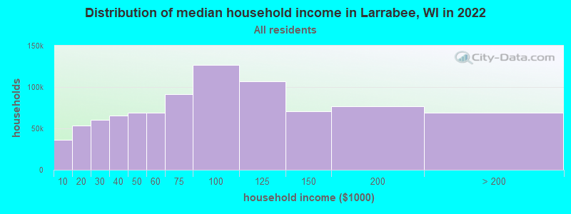
| Larrabee: | $74,778 |
| WI: | $70,996 |
Estimated per capita income in 2022: $37,901 (it was $18,044 in 2000)
Larrabee town income, earnings, and wages data
Estimated median house or condo value in 2022: $198,198 (it was $93,200 in 2000)
| Larrabee: | $198,198 |
| WI: | $252,800 |
Mean prices in 2022: all housing units: $242,326; detached houses: $243,599; townhouses or other attached units: $213,855; in 2-unit structures: $165,520; in 3-to-4-unit structures: over $1,000,000; in 5-or-more-unit structures: $247,705; mobile homes: $177,749
Detailed information about poverty and poor residents in Larrabee, WI


- 1,30294.3%White alone
- 463.3%Hispanic
- 221.6%Two or more races
- 60.4%American Indian alone
- 50.4%Asian alone
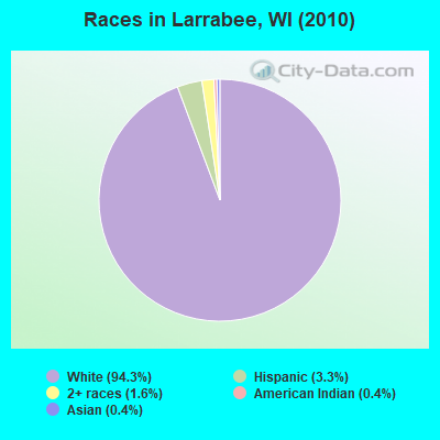
Races in Larrabee detailed stats: ancestries, foreign born residents, place of birth
 Recent articles from our blog. Our writers, many of them Ph.D. graduates or candidates, create easy-to-read articles on a wide variety of topics.


 | Good Dentist in Milwaukee? (2 replies) |
Latest news from Larrabee, WI collected exclusively by city-data.com from local newspapers, TV, and radio stations
Ancestries: German (58.0%), Irish (6.9%), Norwegian (6.0%), Polish (5.1%), United States (4.8%), English (4.7%).
Current Local Time: CST time zone
Elevation: 741 feet
Land area: 33.4 square miles.
Population density: 41 people per square mile (very low).
2 residents are foreign born
| This town: | 0.2% |
| Wisconsin: | 3.6% |
| Larrabee town: | 1.3% ($1,183) |
| Wisconsin: | 2.0% ($2,245) |
Nearest city with pop. 50,000+: Appleton, WI  (32.1 miles , pop. 70,087).
Nearest city with pop. 200,000+: Madison, WI (111.9 miles , pop. 208,054).
Nearest city with pop. 1,000,000+: Chicago, IL (201.3 miles , pop. 2,896,016).
Nearest cities:
), ), ), ), ), Latitude: 44.63 N, Longitude: 88.80 W
Area code commonly used in this area: 715

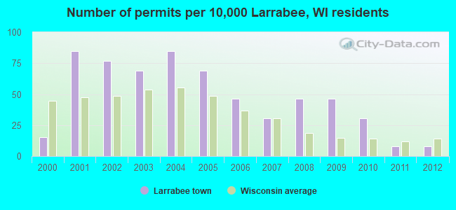
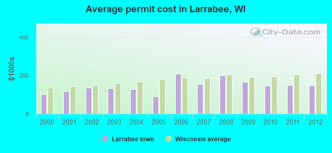
Single-family new house construction building permits:
- 2012: 1 building, cost: $146,300
- 2011: 1 building, cost: $150,000
- 2010: 4 buildings, average cost: $146,300
- 2009: 6 buildings, average cost: $166,400
- 2008: 6 buildings, average cost: $199,200
- 2007: 4 buildings, average cost: $156,300
- 2006: 6 buildings, average cost: $207,700
- 2005: 9 buildings, average cost: $90,600
- 2004: 11 buildings, average cost: $128,600
- 2003: 9 buildings, average cost: $132,500
- 2002: 10 buildings, average cost: $135,200
- 2001: 11 buildings, average cost: $117,800
- 2000: 2 buildings, average cost: $102,000
| Here: | 2.8% |
| Wisconsin: | 2.7% |
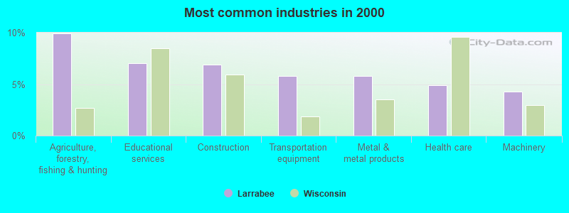
- Agriculture, forestry, fishing & hunting (9.9%)
- Educational services (7.0%)
- Construction (6.9%)
- Transportation equipment (5.8%)
- Metal & metal products (5.8%)
- Health care (4.9%)
- Machinery (4.3%)
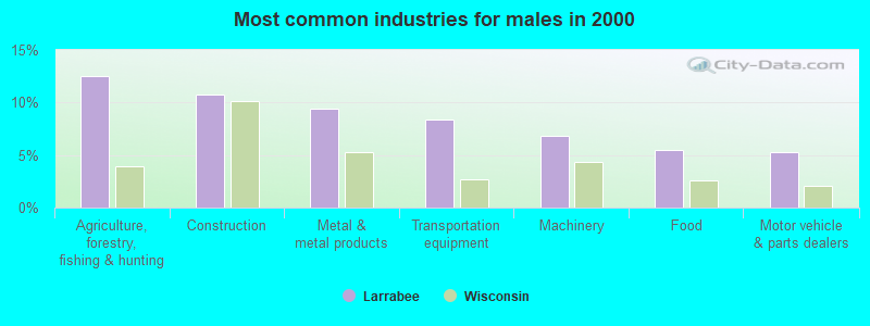
- Agriculture, forestry, fishing & hunting (12.6%)
- Construction (10.7%)
- Metal & metal products (9.4%)
- Transportation equipment (8.4%)
- Machinery (6.8%)
- Food (5.5%)
- Motor vehicle & parts dealers (5.2%)
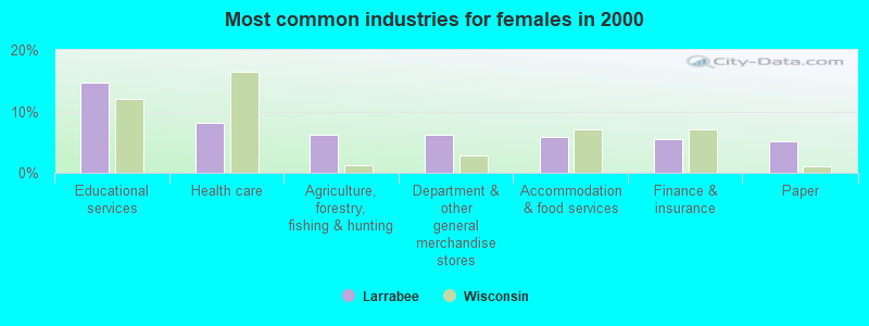
- Educational services (14.7%)
- Health care (8.1%)
- Agriculture, forestry, fishing & hunting (6.2%)
- Department & other general merchandise stores (6.2%)
- Accommodation & food services (5.9%)
- Finance & insurance (5.5%)
- Paper (5.1%)
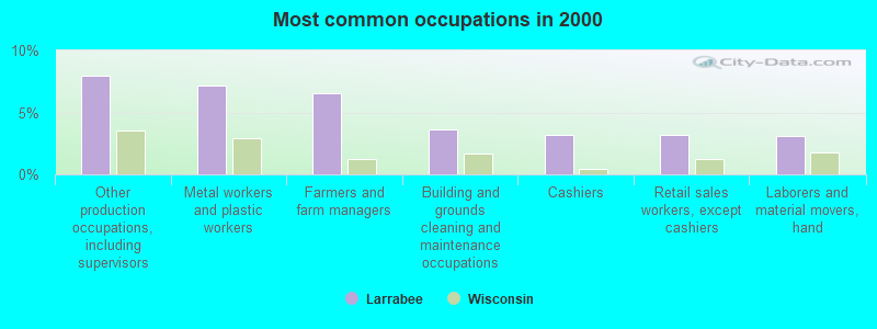
- Other production occupations, including supervisors (8.0%)
- Metal workers and plastic workers (7.2%)
- Farmers and farm managers (6.6%)
- Building and grounds cleaning and maintenance occupations (3.7%)
- Cashiers (3.2%)
- Retail sales workers, except cashiers (3.2%)
- Laborers and material movers, hand (3.1%)
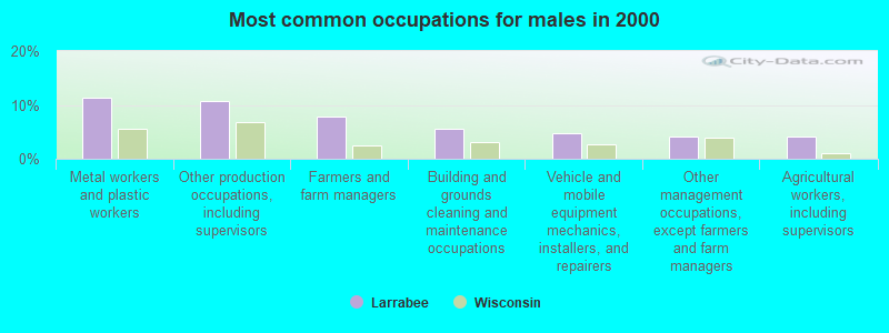
- Metal workers and plastic workers (11.3%)
- Other production occupations, including supervisors (10.7%)
- Farmers and farm managers (7.9%)
- Building and grounds cleaning and maintenance occupations (5.5%)
- Vehicle and mobile equipment mechanics, installers, and repairers (4.7%)
- Other management occupations, except farmers and farm managers (4.2%)
- Agricultural workers, including supervisors (4.2%)
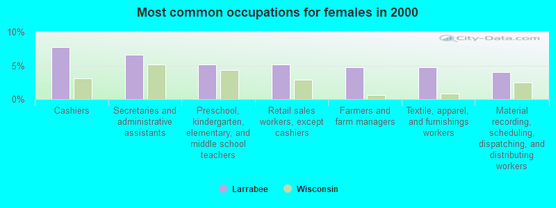
- Cashiers (7.7%)
- Secretaries and administrative assistants (6.6%)
- Preschool, kindergarten, elementary, and middle school teachers (5.1%)
- Retail sales workers, except cashiers (5.1%)
- Farmers and farm managers (4.8%)
- Textile, apparel, and furnishings workers (4.8%)
- Material recording, scheduling, dispatching, and distributing workers (4.0%)
Average climate in Larrabee, Wisconsin
Based on data reported by over 4,000 weather stations


Tornado activity:
Larrabee-area historical tornado activity is near Wisconsin state average. It is 11% greater than the overall U.S. average.
On 9/26/1951, a category F4 (max. wind speeds 207-260 mph) tornado 11.4 miles away from the Larrabee town center killed 6 people and injured 3 people and caused between $50,000 and $500,000 in damages.
On 4/27/1984, a category F4 tornado 27.7 miles away from the town center killed one person and injured 19 people and caused between $500,000 and $5,000,000 in damages.
Earthquake activity:
Larrabee-area historical earthquake activity is significantly above Wisconsin state average. It is 15% smaller than the overall U.S. average.On 6/28/2004 at 06:10:52, a magnitude 4.2 (4.2 MW, Depth: 6.2 mi, Class: Light, Intensity: IV - V) earthquake occurred 219.6 miles away from Larrabee center
On 4/18/2008 at 09:36:59, a magnitude 5.4 (5.1 MB, 4.8 MS, 5.4 MW, 5.2 MW, Class: Moderate, Intensity: VI - VII) earthquake occurred 430.2 miles away from the city center
On 5/2/2015 at 16:23:07, a magnitude 4.2 (4.2 MW, Depth: 2.8 mi) earthquake occurred 236.9 miles away from Larrabee center
On 6/10/1987 at 23:48:54, a magnitude 5.1 (4.9 MB, 4.4 MS, 4.6 MS, 5.1 LG) earthquake occurred 404.8 miles away from Larrabee center
On 2/10/2010 at 09:59:35, a magnitude 3.8 (3.8 MW, Depth: 6.2 mi, Class: Light, Intensity: II - III) earthquake occurred 185.0 miles away from the city center
On 4/18/2008 at 09:36:59, a magnitude 5.2 (5.2 MW, Depth: 8.9 mi) earthquake occurred 430.2 miles away from the city center
Magnitude types: regional Lg-wave magnitude (LG), body-wave magnitude (MB), surface-wave magnitude (MS), moment magnitude (MW)
Natural disasters:
The number of natural disasters in Waupaca County (9) is smaller than the US average (15).Major Disasters (Presidential) Declared: 6
Emergencies Declared: 2
Causes of natural disasters: Floods: 6, Storms: 5, Tornadoes: 3, Drought: 1, Hurricane: 1, Wind: 1, Other: 1 (Note: some incidents may be assigned to more than one category).

Hospitals and medical centers near Larrabee:
- BEHLING MEMORIAL HOME INC (Nursing Home, about 3 miles away; CLINTONVILLE, WI)
- CLINTONVILLE COMMUNITY HOSPITAL (Hospital, about 3 miles away; CLINTONVILLE, WI)
- PINE MANOR HEALTH CARE CENTER (Nursing Home, about 5 miles away; CLINTONVILLE, WI)
- FMC - SHAWANO (Dialysis Facility, about 13 miles away; SHAWANO, WI)
- MANORCARE HEALTH SERVICES-SHAWANO (Nursing Home, about 13 miles away; SHAWANO, WI)
- MANAWA COM NUR CTR (Nursing Home, about 14 miles away; MANAWA, WI)
- EVERGREEN CARE CTR (Nursing Home, about 14 miles away; SHAWANO, WI)
Colleges/universities with over 2000 students nearest to Larrabee:
- Fox Valley Technical College (about 30 miles; Appleton, WI; Full-time enrollment: 5,682)
- Lawrence University (about 33 miles; Appleton, WI; FT enrollment: 2,821)
- Northeast Wisconsin Technical College (about 35 miles; Green Bay, WI; FT enrollment: 6,069)
- Saint Norbert College (about 39 miles; De Pere, WI; FT enrollment: 2,324)
- University of Wisconsin-Stevens Point (about 39 miles; Stevens Point, WI; FT enrollment: 9,089)
- University of Wisconsin-Green Bay (about 44 miles; Green Bay, WI; FT enrollment: 5,415)
- University of Wisconsin-Oshkosh (about 44 miles; Oshkosh, WI; FT enrollment: 10,637)
Points of interest:
Cemeteries: Townline Cemetery (1), Saint Martin Cemetery (2). Display/hide their locations on the map
Reservoirs and swamps: Pigeon Lake (A), Marble Swamp (B). Display/hide their locations on the map
Rivers and creeks: Hydes Creek (A), North Branch Pigeon River (B), Brandy Creek (C), South Branch Pigeon River (D). Display/hide their locations on the map
| This town: | 2.6 people |
| Wisconsin: | 2.4 people |
| This town: | 79.3% |
| Whole state: | 64.4% |
| This town: | 4.8% |
| Whole state: | 7.3% |
Likely homosexual households (counted as self-reported same-sex unmarried-partner households)
- Lesbian couples: 0.4% of all households
- Gay men: 0.6% of all households
| This town: | 5.9% |
| Whole state: | 8.7% |
| This town: | 2.6% |
| Whole state: | 3.7% |
For population 15 years and over in Larrabee:
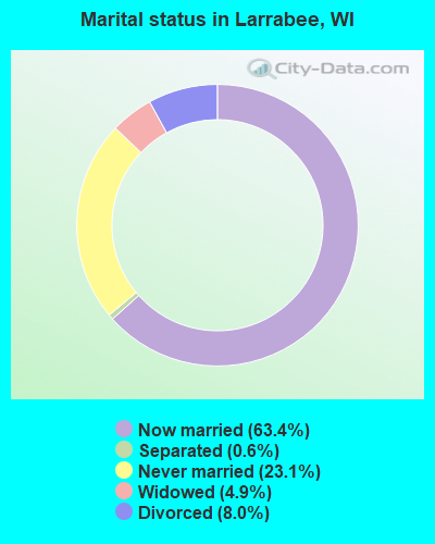
- Never married: 23.1%
- Now married: 63.4%
- Separated: 0.6%
- Widowed: 4.9%
- Divorced: 8.0%
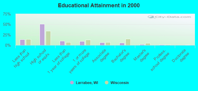
For population 25 years and over in Larrabee:
- High school or higher: 86.1%
- Bachelor's degree or higher: 9.4%
- Graduate or professional degree: 3.9%
- Unemployed: 2.1%
- Mean travel time to work (commute): 23.4 minutes
| Here: | 9.3 |
| Wisconsin average: | 11.0 |
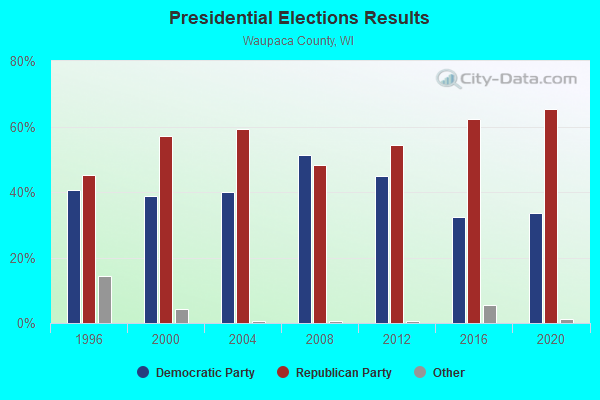
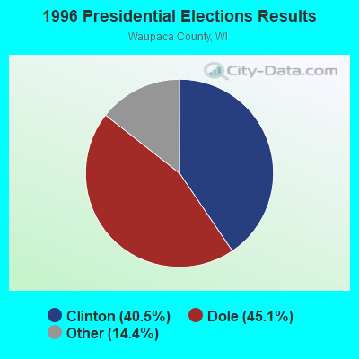
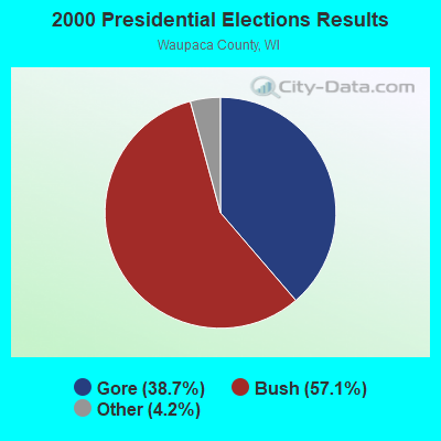
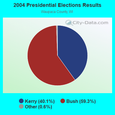
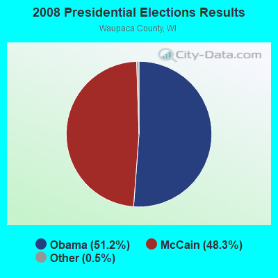
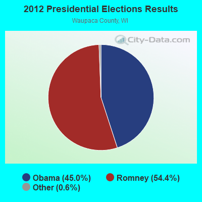
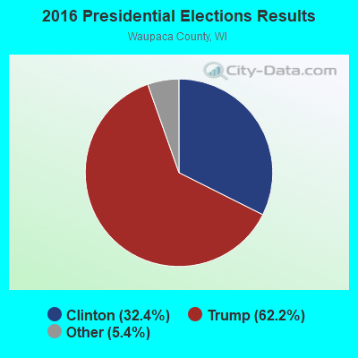
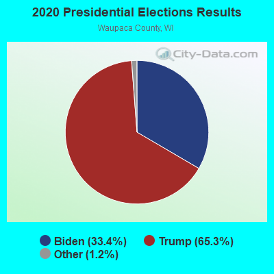
Graphs represent county-level data. Detailed 2008 Election Results
Religion statistics for Larrabee, WI (based on Waupaca County data)
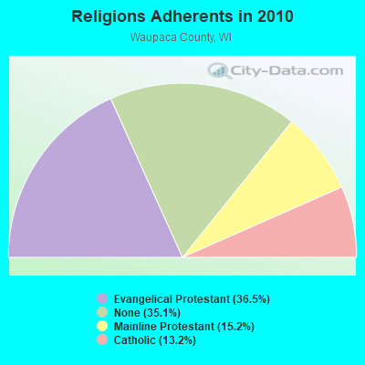
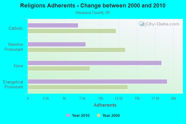
| Religion | Adherents | Congregations |
|---|---|---|
| Evangelical Protestant | 19,152 | 62 |
| Mainline Protestant | 7,941 | 18 |
| Catholic | 6,932 | 7 |
| Other | 9 | 3 |
| None | 18,376 | - |
Food Environment Statistics:
| Here: | 1.93 / 10,000 pop. |
| State: | 1.86 / 10,000 pop. |
| Waupaca County: | 6.35 / 10,000 pop. |
| Wisconsin: | 4.12 / 10,000 pop. |
| This county: | 9.63 / 10,000 pop. |
| Wisconsin: | 8.64 / 10,000 pop. |
| This county: | 7.9% |
| Wisconsin: | 7.6% |
| Here: | 27.6% |
| Wisconsin: | 27.5% |
| Waupaca County: | 11.4% |
| Wisconsin: | 13.0% |
Strongest AM radio stations in Larrabee:
- WFCL (1380 AM; 4 kW; CLINTONVILLE, WI; Owner: RESULTS BROADCASTING CORP.)
- WSPT (1010 AM; 50 kW; STEVENS POINT, WI)
- WNAM (1280 AM; 50 kW; NEENAH-MENASHA, WI; Owner: CUMULUS LICENSING CORP.)
- WSAU (550 AM; 20 kW; WAUSAU, WI; Owner: WRIG, INC.)
- WHBY (1150 AM; 25 kW; KIMBERLY, WI; Owner: WOODWARD COMMUNICATIONS, INC.)
- WDUX (800 AM; 5 kW; WAUPACA, WI; Owner: LAIRD BROADCASTING COMPANY, INC.)
- WTCH (960 AM; 1 kW; SHAWANO, WI; Owner: RESULTS BROADCASTING OF SHAWANO, INC.)
- WTAQ (1360 AM; 10 kW; GREEN BAY, WI; Owner: MIDWEST COMMUNICATIONS, INC.)
- WTMJ (620 AM; 50 kW; MILWAUKEE, WI; Owner: JOURNAL BROADCAST CORPORATION)
- WRIG (1390 AM; 10 kW; SCHOFIELD, WI; Owner: WRIG, INC.)
- WISN (1130 AM; 50 kW; MILWAUKEE, WI; Owner: CAPSTAR TX LIMITED PARTNERSHIP)
- WTCM (580 AM; 35 kW; TRAVERSE CITY, MI; Owner: WTCM RADIO, INC.)
- WNFL (1440 AM; 5 kW; GREEN BAY, WI; Owner: MIDWEST COMMUNICATIONS, INC.)
Strongest FM radio stations in Larrabee:
- WJMQ (92.3 FM; CLINTONVILLE, WI; Owner: RESULTS BROADCASTING CORP.)
- WOZZ (93.5 FM; NEW LONDON, WI; Owner: MIDWEST COMMUNICATIONS, INC)
- WAPL-FM (105.7 FM; APPLETON, WI; Owner: WOODWARD COMMUNICATIONS, INC.)
- WRVM (102.7 FM; SURING, WI; Owner: WRVM, INC.)
- WIXX (101.1 FM; GREEN BAY, WI; Owner: MIDWEST COMMUNICATIONS, INC.)
- WYCO (107.9 FM; WAUSAU, WI; Owner: SEEHAFER BROADCASTING CORPORATION)
- WHID (88.1 FM; GREEN BAY, WI; Owner: BD OF REGENTS OF THE UNIV OF WI SYS)
- WPNE-FM (89.3 FM; GREEN BAY, WI; Owner: WISCONSIN EDUCATIONAL COMMUNICATIONS BOARD)
- WOWN (99.3 FM; SHAWANO, WI; Owner: RESULTS BROADCASTING OF SHAWANO, INC.)
- WECB (104.3 FM; SEYMOUR, WI; Owner: WOODWARD COMMUNICATIONS, INC.)
TV broadcast stations around Larrabee:
- WIWB (Channel 14; SURING, WI; Owner: ACME TV LICENSES OF WISCONSIN, LLC)
- W66DC (Channel 66; WAUPACA, WI; Owner: TRINITY BROADCASTING NETWORK)
- WBAY-TV (Channel 2; GREEN BAY, WI; Owner: YOUNG BROADCASTING OF GREEN BAY, INC.)
- WLUK-TV (Channel 11; GREEN BAY, WI; Owner: EMMIS TELEVISION LICENSE CORPORATION)
- WFRV-TV (Channel 5; GREEN BAY, WI; Owner: CBS BROADCASTING INC.)
- WPNE (Channel 38; GREEN BAY, WI; Owner: WISCONSIN EDUCATIONAL COMMUNICATIONS BOARD)
- W24BV (Channel 24; WHITING, WI; Owner: MS COMMUNICATIONS, LLC)
- WFXS (Channel 55; WITTENBERG, WI; Owner: DAVIS TELEVISION WAUSAU, LLC)
- WGBA (Channel 26; GREEN BAY, WI; Owner: ARIES TELECOMMUNICATION CORPORATION)
- National Bridge Inventory (NBI) Statistics
- 3Number of bridges
- 13ft / 4.3mTotal length
- $176,000Total costs
- 5,996Total average daily traffic
- 517Total average daily truck traffic
- 7,043Total future (year 2038) average daily traffic
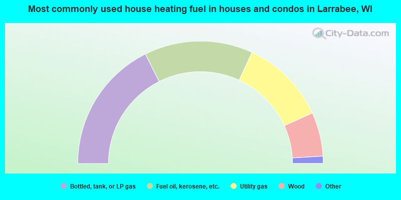
- 35.2%Bottled, tank, or LP gas
- 28.6%Fuel oil, kerosene, etc.
- 22.7%Utility gas
- 11.6%Wood
- 0.9%Electricity
- 0.5%Solar energy
- 0.5%Other fuel
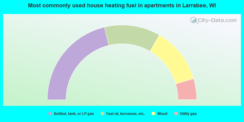
- 42.4%Bottled, tank, or LP gas
- 24.2%Fuel oil, kerosene, etc.
- 24.2%Wood
- 9.1%Utility gas
Larrabee compared to Wisconsin state average:
- Unemployed percentage significantly below state average.
- Black race population percentage significantly below state average.
- Hispanic race population percentage below state average.
- Foreign-born population percentage significantly below state average.
- Renting percentage significantly below state average.
- Length of stay since moving in significantly above state average.
- Number of rooms per house significantly below state average.
- House age significantly below state average.
- Number of college students below state average.
- Percentage of population with a bachelor's degree or higher significantly below state average.
State forum archive: