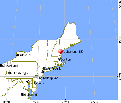
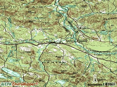
Lebanon, Maine
Submit your own pictures of this town and show them to the world
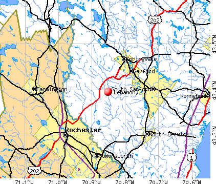
- OSM Map
- General Map
- Google Map
- MSN Map
Population change since 2000: +18.7%
 |
| Males: 3,047 | |
| Females: 2,984 |
| Median resident age: | 39.3 years |
| Maine median age: | 43.0 years |
Zip codes: 04027.
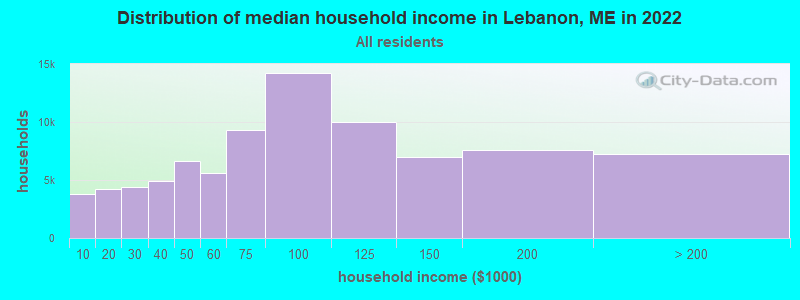
| Lebanon: | $75,151 |
| ME: | $69,543 |
Estimated per capita income in 2022: $31,539 (it was $15,503 in 2000)
Lebanon town income, earnings, and wages data
Estimated median house or condo value in 2022: $307,276 (it was $96,200 in 2000)
| Lebanon: | $307,276 |
| ME: | $290,600 |
Mean prices in 2022: all housing units: $451,552; detached houses: $470,451; townhouses or other attached units: $577,335; in 2-unit structures: $383,179; in 3-to-4-unit structures: $310,696; in 5-or-more-unit structures: $252,113; mobile homes: $105,501
Detailed information about poverty and poor residents in Lebanon, ME
Compare current foreclosures near Lebanon, ME:
| Photo | Address | Area | Beds / Baths | Price | Details |
|---|---|---|---|---|---|

|
#1
T M Wentworth Rd
Lebanon, ME 04027
|
- sq. feet
|
- baths - beds |
show details | |

|
#2
Little River Rd
Lebanon, ME 04027
|
- sq. feet
|
- baths - beds |
show details | |

|
#3
Linden St
Rochester, NH 03867
|
1,648 sq. feet
|
2 baths 3 beds |
show details | |

|
#4
Mcdaniel Shore Dr
Barrington, NH 03825
|
2,681 sq. feet
|
1 baths 3 beds |
show details | |

|
#5
Utah Way
Milton, NH 03851
|
800 sq. feet
|
1 baths 2 beds |
show details | |

|
#6
Great East Ln
Sanbornville, NH 03872
|
1,963 sq. feet
|
2 baths 3 beds |
show details | |

|
#7
Varney Rd
Center Barnstead, NH 03225
|
1,743 sq. feet
|
1 baths 3 beds |
show details | |

|
#8
Charles St
Farmington, NH 03835
|
1,066 sq. feet
|
1 baths 3 beds |
show details | |

|
#9
Hobart St
Rochester, NH 03867
|
1,204 sq. feet
|
1 baths 4 beds |
show details | |

|
#10
Old Dover Rd
Rochester, NH 03867
|
- sq. feet
|
1 baths 3 beds |
show details |
| Photo | Address | Area | Beds / Baths | Price | Details |
|---|---|---|---|---|---|

|
#11
Chapel St
Dover, NH 03820
|
1,872 sq. feet
|
2 baths 4 beds |
show details | |

|
#12
Main St
Sanford, ME 04073
|
- sq. feet
|
2 baths 3 beds |
show details | |

|
#13
1st Crown Point Rd
Strafford, NH 03884
|
1,738 sq. feet
|
1 baths 3 beds |
show details | |

|
#14
Stoneham Road F/k/a 37 Stoneham Road
Sanbornville, NH Array
|
723 sq. feet
|
1 baths 2 beds |
show details | |

|
#15
Northam Dr
Dover, NH 03820
|
1,999 sq. feet
|
2 baths 3 beds |
show details | |

|
#16
Meaderboro Rd
Rochester, NH 03867
|
- sq. feet
|
2 baths 3 beds |
show details | |

|
#17
Roller Coaster Rd
Strafford, NH 03884
|
2,530 sq. feet
|
3 baths 6 beds |
show details | |

|
#18
Frank C Gilman Hwy
Alton, NH 03809
|
1,712 sq. feet
|
1 baths 3 beds |
show details | |

|
#19
Back River Rd
Dover, NH 03820
|
1,193 sq. feet
|
1 baths 3 beds |
show details | |

|
#20
Middle Rd
Dover, NH 03820
|
1,120 sq. feet
|
1 baths 3 beds |
show details |
| Photo | Address | Area | Beds / Baths | Price | Details |
|---|---|---|---|---|---|

|
#21
Olde Farm Way
Berwick, ME 03901
|
2,376 sq. feet
|
3 baths - beds |
show details | |

|
#22
Keay Rd
Berwick, ME 03901
|
2,556 sq. feet
|
2 baths - beds |
show details | |

|
#23
Locksmith Ln
Wells, ME 04090
|
1,212 sq. feet
|
1 baths - beds |
show details | |

|
#24
Pine Hill Rd
Berwick, ME 03901
|
2,882 sq. feet
|
2 baths - beds |
show details | |

|
#25
Royal Dr, Unit 301
Somersworth, NH 03878
|
- sq. feet
|
- baths - beds |
show details | |

|
#26
Biddeford Rd
Alfred, ME 04002
|
- sq. feet
|
- baths - beds |
show details | |

|
#27
Berry River Rd
Barrington, NH 03825
|
- sq. feet
|
- baths - beds |
show details | |

|
#28
Fire Rd
Strafford, NH 03884
|
- sq. feet
|
- baths - beds |
show details | |

|
#29
New York St
Dover, NH 03820
|
- sq. feet
|
- baths - beds |
show details | |

|
#30
Rogers St # B
Dover, NH 03820
|
- sq. feet
|
- baths - beds |
show details |
| Photo | Address | Area | Beds / Baths | Price | Details |
|---|---|---|---|---|---|

|
#31
1st St, Apt 210-1
Dover, NH 03820
|
- sq. feet
|
- baths - beds |
show details | |

|
#32
Canal St Unit 307
North Berwick, ME 03906
|
- sq. feet
|
- baths - beds |
show details | |

|
#33
Arianna Dr
Alton, NH 03809
|
- sq. feet
|
- baths - beds |
show details | |

|
#34
Stoneham Rd
Sanbornville, NH 03872
|
- sq. feet
|
- baths - beds |
show details | |

|
#35
Basswood St
Alfred, ME 04002
|
- sq. feet
|
- baths - beds |
show details | |

|
#36
Fire Road 1
Strafford, NH 03884
|
- sq. feet
|
- baths - beds |
show details | |

|
#37
Blackberry Hill Rd
Berwick, ME 03901
|
- sq. feet
|
- baths - beds |
show details | |

|
#38
Asteria Ln, Unit 105
Rochester, NH 03867
|
- sq. feet
|
- baths - beds |
show details | |

|
#39
Ross Corner Rd
Shapleigh, ME 04076
|
- sq. feet
|
- baths - beds |
show details | |

|
#40
Cedarbrook V 4e
Rochester, NH 03867
|
- sq. feet
|
- baths - beds |
show details |
| Photo | Address | Area | Beds / Baths | Price | Details |
|---|---|---|---|---|---|

|
#41
Fire 1 Rd
Strafford, NH 03884
|
- sq. feet
|
- baths - beds |
show details | |

|
#42
White Mountain Hwy
Milton, NH 03851
|
- sq. feet
|
- baths - beds |
show details | |

|
#43
Limestone Ln
Rochester, NH 03867
|
- sq. feet
|
- baths - beds |
show details | |

|
#44
Main St
Springvale, ME 04083
|
- sq. feet
|
- baths - beds |
show details | |

|
#45
Main St Apt 404
Sanford, ME 04073
|
- sq. feet
|
- baths - beds |
show details | |

|
#46
Central St Apt 33
Farmington, NH 03835
|
- sq. feet
|
- baths - beds |
show details | |

|
#47
France Rd
Barrington, NH 03825
|
- sq. feet
|
- baths - beds |
show details | |

|
#48
Route 236 Apt F4
Berwick, ME 03901
|
- sq. feet
|
- baths - beds |
show details | |

|
#49
Old Dover Rd
Rochester, NH 03867
|
- sq. feet
|
- baths - beds |
show details | |

|
Check over 1 million property listings on Foreclosure.com!
|
browse all offers | |||

- 5,80696.3%White alone
- 751.2%Two or more races
- 570.9%Hispanic
- 500.8%Asian alone
- 260.4%Black alone
- 150.2%American Indian alone
- 20.03%Other race alone
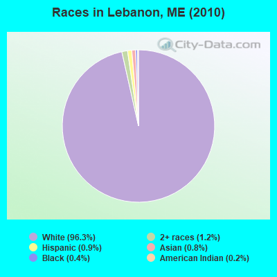
Races in Lebanon detailed stats: ancestries, foreign born residents, place of birth
According to our research of Maine and other state lists, there were 15 registered sex offenders living in Lebanon, Maine as of April 23, 2024.
The ratio of all residents to sex offenders in Lebanon is 402 to 1.
 Recent articles from our blog. Our writers, many of them Ph.D. graduates or candidates, create easy-to-read articles on a wide variety of topics.


 | Retired looking for a final destination. Please help me decide. (24 replies) |
| Moving from Southern California to Coastal Maine soon. (16 replies) |
| Maine Demographics (36 replies) |
| Days after minimum wage rises, Maine diner near nh cuts staff hours. (292 replies) |
| visiting nh and lebanon me...suggestions (5 replies) |
| Questions about Portland Maine (13 replies) |
Latest news from Lebanon, ME collected exclusively by city-data.com from local newspapers, TV, and radio stations
Lebanon, ME City Guides:
Ancestries: French (23.3%), English (22.7%), Irish (16.2%), United States (11.9%), German (6.0%), French Canadian (5.6%).
Current Local Time: EST time zone
Incorporated on 06/17/1767
Elevation: 305 feet
Land area: 54.7 square miles.
Population density: 110 people per square mile (very low).
132 residents are foreign born (1.3% North America, 1.0% Europe, 0.3% Asia).
| This town: | 2.6% |
| Maine: | 2.9% |
| Lebanon town: | 1.2% ($1,176) |
| Maine: | 1.5% ($1,417) |
Nearest city with pop. 50,000+: Portland, ME  (37.2 miles , pop. 64,249).
Nearest city with pop. 200,000+: Boston, MA (75.3 miles , pop. 589,141).
Nearest city with pop. 1,000,000+: Bronx, NY (232.9 miles , pop. 1,332,650).
Nearest cities:
), ), ), )Latitude: 43.40 N, Longitude: 70.92 W
Area code: 207

Single-family new house construction building permits:
- 2022: 38 buildings, average cost: $237,200
- 2021: 38 buildings, average cost: $193,100
- 2020: 31 buildings, average cost: $50,300
- 2019: 26 buildings, average cost: $154,000
- 2018: 27 buildings, average cost: $154,000
- 2017: 27 buildings, average cost: $154,000
- 2016: 28 buildings, average cost: $154,000
- 2015: 26 buildings, average cost: $154,000
- 2014: 13 buildings, average cost: $235,000
- 2013: 17 buildings, average cost: $233,900
- 2011: 25 buildings, average cost: $72,800
- 2010: 13 buildings, average cost: $108,100
- 2009: 19 buildings, average cost: $130,000
- 2008: 25 buildings, average cost: $166,900
- 2007: 37 buildings, average cost: $133,500
- 2006: 46 buildings, average cost: $51,400
- 2005: 52 buildings, average cost: $51,400
- 2004: 119 buildings, average cost: $105,100
- 2003: 23 buildings, average cost: $73,000
- 2002: 20 buildings, average cost: $58,600
- 2001: 19 buildings, average cost: $58,600
- 2000: 19 buildings, average cost: $58,600
- 1999: 15 buildings, average cost: $58,600
- 1998: 13 buildings, average cost: $58,600
- 1997: 11 buildings, average cost: $58,600
| Here: | 3.2% |
| Maine: | 3.4% |
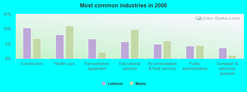
- Construction (10.4%)
- Health care (8.1%)
- Transportation equipment (6.7%)
- Educational services (5.6%)
- Accommodation & food services (4.9%)
- Public administration (4.2%)
- Computer & electronic products (3.6%)
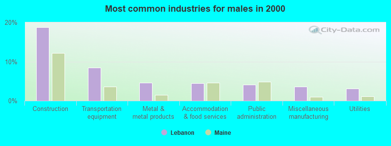
- Construction (18.8%)
- Transportation equipment (8.4%)
- Metal & metal products (4.6%)
- Accommodation & food services (4.4%)
- Public administration (4.1%)
- Miscellaneous manufacturing (3.6%)
- Utilities (3.1%)
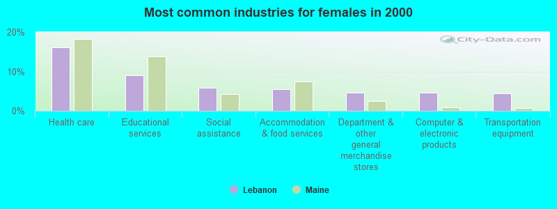
- Health care (16.0%)
- Educational services (9.0%)
- Social assistance (5.8%)
- Accommodation & food services (5.5%)
- Department & other general merchandise stores (4.7%)
- Computer & electronic products (4.6%)
- Transportation equipment (4.5%)
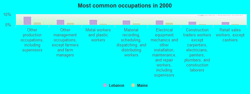
- Other production occupations, including supervisors (8.1%)
- Other management occupations, except farmers and farm managers (5.1%)
- Metal workers and plastic workers (5.1%)
- Material recording, scheduling, dispatching, and distributing workers (4.7%)
- Electrical equipment mechanics and other installation, maintenance, and repair workers, including supervisors (4.6%)
- Construction traders workers except carpenters, electricians, painters, plumbers, and construction laborers (3.3%)
- Retail sales workers, except cashiers (2.9%)
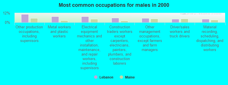
- Other production occupations, including supervisors (10.4%)
- Metal workers and plastic workers (7.7%)
- Electrical equipment mechanics and other installation, maintenance, and repair workers, including supervisors (7.5%)
- Construction traders workers except carpenters, electricians, painters, plumbers, and construction laborers (5.9%)
- Other management occupations, except farmers and farm managers (5.3%)
- Driver/sales workers and truck drivers (4.5%)
- Material recording, scheduling, dispatching, and distributing workers (4.2%)
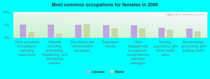
- Other production occupations, including supervisors (5.3%)
- Material recording, scheduling, dispatching, and distributing workers (5.3%)
- Secretaries and administrative assistants (5.2%)
- Registered nurses (5.0%)
- Other management occupations, except farmers and farm managers (4.9%)
- Nursing, psychiatric, and home health aides (4.0%)
- Bookkeeping, accounting, and auditing clerks (3.8%)
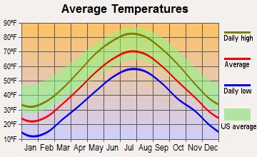
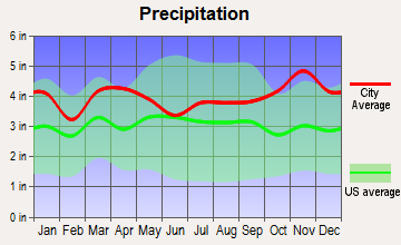
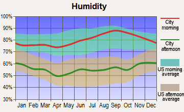
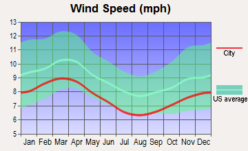
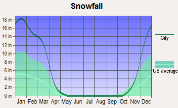
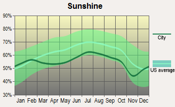
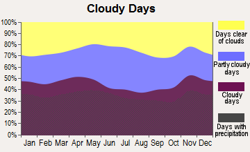
Average climate in Lebanon, Maine
Based on data reported by over 4,000 weather stations
(lower is better)
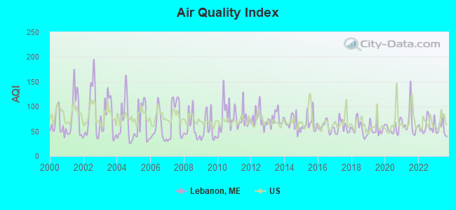
Air Quality Index (AQI) level in 2023 was 54.6. This is better than average.
| City: | 54.6 |
| U.S.: | 72.6 |
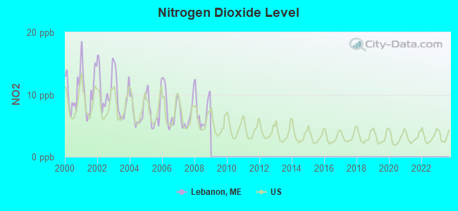
Nitrogen Dioxide (NO2) [ppb] level in 2008 was 7.38. This is significantly worse than average. Closest monitor was 14.7 miles away from the city center.
| City: | 7.38 |
| U.S.: | 5.11 |
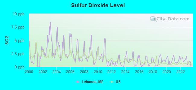
Sulfur Dioxide (SO2) [ppb] level in 2022 was 1.48. This is about average. Closest monitor was 8.6 miles away from the city center.
| City: | 1.48 |
| U.S.: | 1.51 |
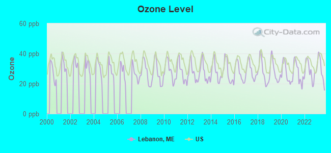
Ozone [ppb] level in 2023 was 29.7. This is about average. Closest monitor was 6.4 miles away from the city center.
| City: | 29.7 |
| U.S.: | 33.3 |
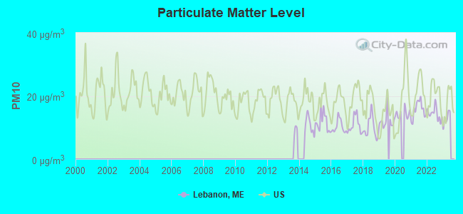
Particulate Matter (PM10) [µg/m3] level in 2022 was 14.4. This is better than average. Closest monitor was 14.7 miles away from the city center.
| City: | 14.4 |
| U.S.: | 19.2 |
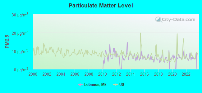
Particulate Matter (PM2.5) [µg/m3] level in 2022 was 6.41. This is better than average. Closest monitor was 23.8 miles away from the city center.
| City: | 6.41 |
| U.S.: | 8.11 |
Tornado activity:
Lebanon-area historical tornado activity is significantly above Maine state average. It is 61% smaller than the overall U.S. average.
On 6/9/1953, a category F3 (max. wind speeds 158-206 mph) tornado 30.1 miles away from the Lebanon town center injured 5 people and caused between $5000 and $50,000 in damages.
On 6/22/1981, a category F2 (max. wind speeds 113-157 mph) tornado 4.5 miles away from the town center caused between $500,000 and $5,000,000 in damages.
Earthquake activity:
Lebanon-area historical earthquake activity is significantly above Maine state average. It is 73% smaller than the overall U.S. average.On 10/16/2012 at 23:12:25, a magnitude 4.7 (4.7 ML, Depth: 10.0 mi, Class: Light, Intensity: IV - V) earthquake occurred 18.8 miles away from the city center
On 4/20/2002 at 10:50:47, a magnitude 5.3 (5.3 ML, Depth: 3.0 mi, Class: Moderate, Intensity: VI - VII) earthquake occurred 158.2 miles away from Lebanon center
On 1/19/1982 at 00:14:42, a magnitude 4.7 (4.5 MB, 4.7 MD, 4.5 LG) earthquake occurred 34.9 miles away from Lebanon center
On 10/7/1983 at 10:18:46, a magnitude 5.3 (5.1 MB, 5.3 LG, 5.1 ML) earthquake occurred 175.5 miles away from Lebanon center
On 4/20/2002 at 10:50:47, a magnitude 5.2 (5.2 MB, 4.2 MS, 5.2 MW, 5.0 MW) earthquake occurred 158.3 miles away from the city center
On 8/21/1996 at 07:54:14, a magnitude 3.8 (3.8 LG, 3.6 LG, Depth: 6.2 mi, Class: Light, Intensity: II - III) earthquake occurred 58.2 miles away from the city center
Magnitude types: regional Lg-wave magnitude (LG), body-wave magnitude (MB), duration magnitude (MD), local magnitude (ML), surface-wave magnitude (MS), moment magnitude (MW)
Natural disasters:
The number of natural disasters in York County (31) is a lot greater than the US average (15).Major Disasters (Presidential) Declared: 23
Emergencies Declared: 8
Causes of natural disasters: Floods: 21, Storms: 16, Winter Storms: 6, Snows: 5, Winds: 3, Heavy Rains: 2, Hurricanes: 2, Blizzard: 1, Ice Storm: 1, Mudslide: 1, Snowfall: 1, Snowstorm: 1, Tornado: 1, Tropical Storm: 1 (Note: some incidents may be assigned to more than one category).
Hospitals and medical centers near Lebanon:
- YOUR VNA (Home Health Center, about 7 miles away; ROCHESTER, NH)
- ROCHESTER MANOR (Nursing Home, about 8 miles away; ROCHESTER, NH)
- FRISBIE MEMORIAL HOSPITAL Acute Care Hospitals (about 8 miles away; ROCHESTER, NH)
- ACADEMY NH INC (Nursing Home, about 8 miles away; ROCHESTER, NH)
- COLONIAL HILL OF ROCHESTER CARE AND REHABILITATION (Nursing Home, about 8 miles away; ROCHESTER, NH)
- HOMEMAKERS HEALTH SERVICES (THE) (Home Health Center, about 9 miles away; ROCHESTER, NH)
- SANFORD HEALTH CARE FACILITY (Nursing Home, about 10 miles away; SANFORD, ME)
Colleges/universities with over 2000 students nearest to Lebanon:
- University of New Hampshire-Main Campus (about 19 miles; Durham, NH; Full-time enrollment: 15,243)
- University of New England (about 27 miles; Biddeford, ME; FT enrollment: 4,539)
- NHTI-Concord's Community College (about 34 miles; Concord, NH; FT enrollment: 2,865)
- Saint Joseph's College of Maine (about 37 miles; Standish, ME; FT enrollment: 2,010)
- University of Southern Maine (about 37 miles; Portland, ME; FT enrollment: 6,647)
- Southern New Hampshire University (about 37 miles; Manchester, NH; FT enrollment: 16,552)
- Southern Maine Community College (about 39 miles; South Portland, ME; FT enrollment: 4,666)
Points of interest:
Notable locations in Lebanon: Potters Place Adult Park Campground (A), Lebanon Area Library (B), Lebanon Fire Department East Lebanon Fire Station (C), Lebanon Rescue Squad (D), Lebanon Fire Department Blaisdell Corner Fire Station (E). Display/hide their locations on the map
Church in Lebanon: North Lebanon Second Baptist Church (A). Display/hide its location on the map
Cemeteries: Prospect Hill Cemetery (1), Forest Grove Cemetery (2). Display/hide their locations on the map
Lakes, reservoirs, and swamps: Wallingford Pond (A), Northeast Pond (B), Black Pond (C), Nisbitt Pond (D), Northeast Pond (E), Sacapee Pond (F), Milton Three Ponds (G), Mousam River Reservoir (H). Display/hide their locations on the map
Streams, rivers, and creeks: Great Brook (A), Bog Brook (B). Display/hide their locations on the map
Parks in Lebanon include: West Lebanon Historic District (1), Stewarts Field (2). Display/hide their locations on the map
Tourist attractions: Fernald Shore (Recreation Areas; 15 T M Wentworth Rd) (1), Destination Orlando Etc (34 Clark Lane) (2). Display/hide their approximate locations on the map
Birthplace of: Elihu B. Hayes - Politician.
Drinking water stations with addresses in Lebanon and their reported violations in the past:
SALMON FALLS RIVER RV RESORT (Population served: 500, Groundwater):Past health violations:POTTERS PLACE ADULT PARK 2 (Population served: 250, Groundwater):Past monitoring violations:
- MCL, Monthly (TCR) - In JUL-2010, Contaminant: Coliform. Follow-up actions: St Public Notif requested (JUL-15-2010), St Formal NOV issued (JUL-15-2010), St Public Notif received (AUG-14-2010), St Compliance achieved (APR-25-2011)
- MCL, Monthly (TCR) - In JUN-2010, Contaminant: Coliform. Follow-up actions: St Public Notif requested (JUN-09-2010), St Formal NOV issued (JUN-09-2010), St Public Notif received (JUN-21-2010), St Compliance achieved (APR-25-2011)
- 3 routine major monitoring violations
- 5 regular monitoring violations
Past monitoring violations:STOKEWOODS DINER (Population served: 250, Groundwater):
- 5 routine major monitoring violations
Past monitoring violations:POTTERS PLACE ADULT PARK (Population served: 250, Groundwater):
- 7 routine major monitoring violations
- One regular monitoring violation
Past health violations:HEAVENLEE ACRES CAMPGROUNDS (Population served: 175, Groundwater):
- MCL, Monthly (TCR) - In JUN-2013, Contaminant: Coliform. Follow-up actions: St Formal NOV issued (JUN-28-2013), St Public Notif requested (JUN-28-2013)
Past monitoring violations:EXTREME AIR LLC (Population served: 113, Groundwater):
- 2 routine major monitoring violations
Past health violations:HOMETOWN MOBIL LLC (Population served: 90, Groundwater):Past monitoring violations:
- MCL, Monthly (TCR) - In JUN-2009, Contaminant: Coliform. Follow-up actions: St Public Notif requested (APR-26-2010), St Formal NOV issued (APR-26-2010), St Compliance achieved (MAY-05-2011), St Intentional no-action (SEP-15-2011)
- Monitoring, Repeat Major (TCR) - In AUG-2006, Contaminant: Coliform (TCR). Follow-up actions: St Public Notif requested (SEP-07-2006), St Violation/Reminder Notice (SEP-07-2006), St AO (w/o penalty) issued (MAY-29-2007), St Compliance achieved (JUN-25-2007), St Public Notif received (2 times from JUL-03-2007 to JUL-03-2007), St Compliance achieved (JUL-12-2007)
- 15 routine major monitoring violations
- 2 regular monitoring violations
Past monitoring violations:TOWN LINE PIZZARIA/BAKERY (Serves NH, Population served: 75, Groundwater):
- 4 routine major monitoring violations
- 2 regular monitoring violations
Past monitoring violations:
- One routine major monitoring violation
Drinking water stations with addresses in Lebanon that have no violations reported:
- COLONIAL MOBILE HOME PARK (Population served: 270, Primary Water Source Type: Groundwater)
| This town: | 2.7 people |
| Maine: | 2.3 people |
| This town: | 76.2% |
| Whole state: | 62.9% |
| This town: | 10.1% |
| Whole state: | 9.4% |
Likely homosexual households (counted as self-reported same-sex unmarried-partner households)
- Lesbian couples: 0.6% of all households
- Gay men: 0.4% of all households
| This town: | 10.4% |
| Whole state: | 10.9% |
| This town: | 4.9% |
| Whole state: | 4.1% |
For population 15 years and over in Lebanon:
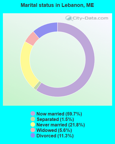
- Never married: 21.8%
- Now married: 59.7%
- Separated: 1.5%
- Widowed: 5.6%
- Divorced: 11.3%
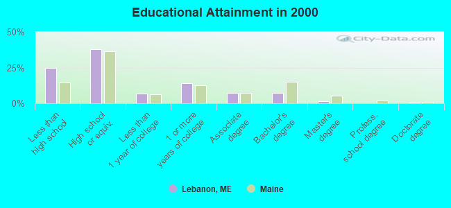
For population 25 years and over in Lebanon:
- High school or higher: 75.2%
- Bachelor's degree or higher: 9.4%
- Graduate or professional degree: 2.1%
- Unemployed: 3.3%
- Mean travel time to work (commute): 30.2 minutes
| Here: | 10.2 |
| Maine average: | 11.2 |


Graphs represent county-level data. Detailed 2008 Election Results
Religion statistics for Lebanon, ME (based on York County data)
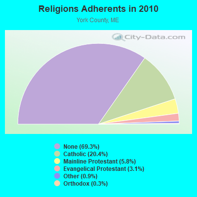

| Religion | Adherents | Congregations |
|---|---|---|
| Catholic | 40,283 | 16 |
| Mainline Protestant | 11,480 | 64 |
| Evangelical Protestant | 6,086 | 51 |
| Other | 1,847 | 18 |
| Orthodox | 625 | 3 |
| Black Protestant | 119 | 1 |
| None | 136,691 | - |
Food Environment Statistics:
| This county: | 2.24 / 10,000 pop. |
| Maine: | 2.80 / 10,000 pop. |
| This county: | 0.05 / 10,000 pop. |
| Maine: | 0.14 / 10,000 pop. |
| This county: | 2.09 / 10,000 pop. |
| State: | 2.20 / 10,000 pop. |
| This county: | 4.23 / 10,000 pop. |
| Maine: | 5.75 / 10,000 pop. |
| York County: | 12.53 / 10,000 pop. |
| State: | 11.02 / 10,000 pop. |
| Here: | 7.7% |
| Maine: | 8.2% |
| York County: | 24.0% |
| State: | 25.0% |
Businesses in Lebanon, ME
- U-Haul: 1
Strongest AM radio stations in Lebanon:
- WGIN (930 AM; 10 kW; ROCHESTER, NH; Owner: CAPSTAR TX LIMITED PARTNERSHIP)
- WRKO (680 AM; 50 kW; BOSTON, MA; Owner: ENTERCOM BOSTON LICENSE, LLC)
- WTSN (1270 AM; 5 kW; DOVER, NH; Owner: GARRISON CITY BROADCASTING, INC.)
- WMTW (870 AM; 10 kW; GORHAM, ME; Owner: RADIO PARTNERS OF MAINE, L.P.)
- WPHX (1220 AM; 1 kW; SANFORD, ME; Owner: FNX BROADCASTING L.L.C.)
- WEEI (850 AM; 50 kW; BOSTON, MA; Owner: ENTERCOM BOSTON LICENSE, LLC)
- WASR (1420 AM; 5 kW; WOLFEBORO, NH; Owner: RADIO WOLFEBORO, INC.)
- WBZ (1030 AM; 50 kW; BOSTON, MA; Owner: INFINITY BROADCASTING OPERATIONS, INC.)
- WWZN (1510 AM; 50 kW; BOSTON, MA; Owner: ROSE CITY RADIO CORPORATION)
- WCRN (830 AM; 50 kW; WORCESTER, MA; Owner: CARTER BROADCASTING CORPORATION)
- WGAN (560 AM; 5 kW; PORTLAND, ME; Owner: SAGA COMMUNICATIONS OF NEW ENGLAND, LLC)
- WKOX (1200 AM; 50 kW; FRAMINGHAM, MA; Owner: CAPSTAR TX LIMITED PARTNERSHIP)
- WBIX (1060 AM; 40 kW; NATICK, MA; Owner: LANGER BROADCASTING CORPORATION)
Strongest FM radio stations in Lebanon:
- WPHX-FM (92.1 FM; SANFORD, ME; Owner: FNX BROADCASTING LLC)
- WSEW (88.5 FM; SANFORD, ME; Owner: WORD RADIO EDUCATIONAL FOUNDATION)
- WMEX (106.5 FM; FARMINGTON, NH; Owner: WIMMEX, LLC)
- WSCY (106.9 FM; MOULTONBOROUGH, NH; Owner: NORTHEAST COMMUNICATIONS CORPORATION)
- WQSO (96.7 FM; ROCHESTER, NH; Owner: CAPSTAR TX LIMITED PARTNERSHIP)
- WMEA (90.1 FM; PORTLAND, ME; Owner: MAINE PUBLIC BROADCASTING CORPORATION)
- WOKQ (97.5 FM; DOVER, NH; Owner: CITADEL BROADCASTING COMPANY)
- WUBB (95.3 FM; YORK CENTER, ME; Owner: CAPSTAR TX LIMITED PARTNERSHIP)
- WPKQ (103.7 FM; NORTH CONWAY, NH; Owner: CITADEL BROADCASTING COMPANY)
- WHOM (94.9 FM; MT. WASHINGTON, NH; Owner: CITADEL BROADCASTING COMPANY)
- WLKZ (104.9 FM; WOLFEBORO, NH; Owner: TELE-MEDIA COMPANY OF NEW HAMPSHIRE, L.L.C.)
- WBYY (98.7 FM; SOMERSWORTH, NH; Owner: GARRISON CITY BROADCASTING, INC.)
- WVFM (105.7 FM; CAMPTON, NH; Owner: DEVON BROADCASTING COMPANY, INC.)
- WNHI (93.3 FM; BELMONT, NH; Owner: CONCORD BROADCASTING, L.L.C.)
- WBLM (102.9 FM; PORTLAND, ME; Owner: CITADEL BROADCASTING COMPANY)
- WSHK (105.3 FM; KITTERY, ME; Owner: CITADEL BROADCASTING COMPANY)
- WPNH-FM (100.1 FM; PLYMOUTH, NH; Owner: NORTHEAST COMMUNICATIONS CORPORATION)
- WGIR-FM (101.1 FM; MANCHESTER, NH; Owner: CAPSTAR TX LIMITED PARTNERSHIP)
- W282AF (104.3 FM; CONCORD, NH; Owner: CONCORD BIBLE FELLOWSHIP)
- WHEB (100.3 FM; PORTSMOUTH, NH; Owner: CAPSTAR TX LIMITED PARTNERSHIP)
TV broadcast stations around Lebanon:
- WMEA-TV (Channel 26; BIDDEFORD, ME; Owner: MAINE PUBLIC BROADCASTING CORP.)
- WMTW-TV (Channel 8; POLAND SPRING, ME; Owner: WMTW BROADCAST GROUP, LLC)
- WCSH (Channel 6; PORTLAND, ME; Owner: PACIFIC AND SOUTHERN COMPANY, INC.)
- WGME-TV (Channel 13; PORTLAND, ME; Owner: WGME LICENSEE, LLC)
- WENH-TV (Channel 11; DURHAM, NH; Owner: UNIVERSITY OF NEW HAMPSHIRE)
- WHDN-LP (Channel 26; BOSTON, MA; Owner: GUENTER MARKSTEINER)
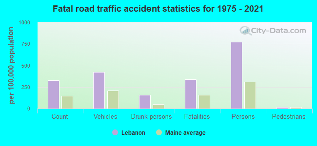
- National Bridge Inventory (NBI) Statistics
- 10Number of bridges
- 59ft / 18.1mTotal length
- 28,865Total average daily traffic
- 1,439Total average daily truck traffic
- 41,462Total future (year 2036) average daily traffic
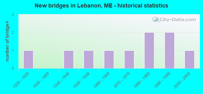
- New bridges - historical statistics
- 11920-1929
- 11940-1949
- 11950-1959
- 11960-1969
- 11970-1979
- 21980-1989
- 21990-1999
- 12000-2009
FCC Registered Antenna Towers:
16 (See the full list of FCC Registered Antenna Towers in Lebanon)FCC Registered Amateur Radio Licenses:
26 (See the full list of FCC Registered Amateur Radio Licenses in Lebanon)FAA Registered Aircraft:
7- Aircraft: CESSNA TU206D (Category: Land, Seats: 6, Weight: Up to 12,499 Pounds, Speed: 132 mph), Engine: CONT MOTOR IO 520 SERIES (285 HP) (Reciprocating)
N-Number: 4194Q, N4194Q, N-4194Q, Serial Number: U2061359, Year manufactured: 1969, Airworthiness Date: 04/03/1993, Certificate Issue Date: 05/27/2003
Registrant (LLC): Jump Run Aviation LLC, 30 Skydive Ln, Lebanon, ME 04027 - Aircraft: CESSNA 172N (Category: Land, Seats: 4, Weight: Up to 12,499 Pounds, Speed: 105 mph), Engine: LYCOMING 0-320 SERIES (180 HP) (Reciprocating)
N-Number: 6490D, N6490D, N-6490D, Serial Number: 17272832, Year manufactured: 1979, Airworthiness Date: 06/09/1979, Certificate Issue Date: 06/06/2019
Registrant (Individual): James W Campbell, 160 Upper Guinea Rd, Lebanon, ME 04027 - Aircraft: CYR RODERICK KOLB MARK 3 (Category: Amphibian, Seats: 2, Weight: Up to 12,499 Pounds), Engine: Reciprocating
N-Number: 7809J, N7809J, N-7809J, Serial Number: M3-078, Certificate Issue Date: 02/04/2020
Registrant (Individual): Roderick J Cyr, 70 Bog Rd, Lebanon, ME 04027 - Aircraft: AIRBORNE WINDSPORTS PTY LTD EDGE XT-582-L (Category: Land, Seats: 2, Weight: Up to 12,499 Pounds), Engine: ROTAX 582UL DCDI (65 HP) (2 Cycle)
N-Number: 94718, N94718, N-94718, Serial Number: XT582 022, Year manufactured: 2006, Airworthiness Date: 01/09/2008, Certificate Issue Date: 12/19/2019
Registrant (Individual): Phillip J D Jr Hubert, Po Box 421, Lebanon, ME 04027 - Aircraft: STINSON 108-1 (Category: Land, Seats: 4, Weight: Up to 12,499 Pounds, Speed: 84 mph), Engine: FRANKLIN 6A4150 SERIES (150 HP) (Reciprocating)
N-Number: 97062, N97062, N-97062, Serial Number: 108-1062, Year manufactured: 1946, Airworthiness Date: 04/28/1956, Certificate Issue Date: 03/30/2020
Registrant (Individual): Robert M Jr Browning, 456 W Lebanon Rd, Lebanon, ME 04027 - Aircraft: CESSNA 182A (Category: Land, Seats: 4, Weight: Up to 12,499 Pounds, Speed: 119 mph), Engine: CONT MOTOR O-470 SERIES (230 HP) (Reciprocating)
N-Number: 9999B, N9999B, N-9999B, Serial Number: 34399, Year manufactured: 1957, Airworthiness Date: 05/31/1957, Certificate Issue Date: 05/27/2003
Registrant (LLC): Jump Run Aviation LLC, 30 Skydive Ln, Lebanon, ME 04027 - Aircraft: WILLSON HOWARD S AVID FLYER (Category: Land, Seats: 2, Weight: Up to 12,499 Pounds), Engine: BOMBARDIER ROTAX (ALL) (Reciprocating)
N-Number: 27KM, N27KM, N-27KM, Serial Number: 885, Year manufactured: 1992, Airworthiness Date: 07/02/1992
Registrant (Individual): Reported Sale, 171 Lower Middle Rd, Lebanon, ME 04027
2003 - 2018 National Fire Incident Reporting System (NFIRS) incidents
- Fire incident types reported to NFIRS in Lebanon, ME
- 17661.8%Structure Fires
- 6723.5%Outside Fires
- 3311.6%Mobile Property/Vehicle Fires
- 93.2%Other
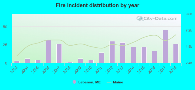 Based on the data from the years 2003 - 2018 the average number of fires per year is 18. The highest number of reported fire incidents - 45 took place in 2017, and the least - 1 in 2008. The data has a rising trend.
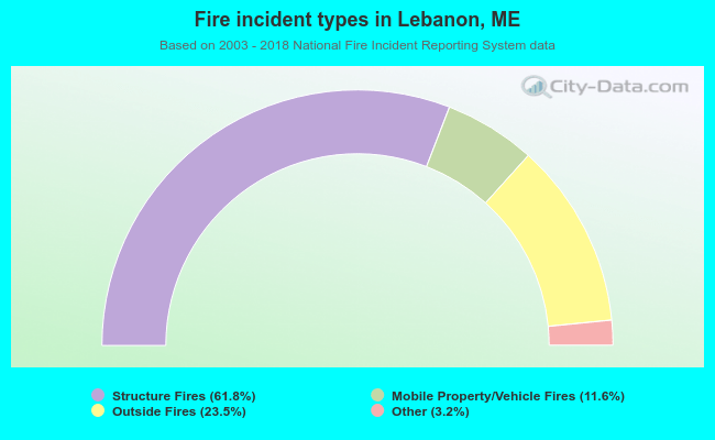 When looking into fire subcategories, the most incidents belonged to: Structure Fires (61.8%), and Outside Fires (23.5%).
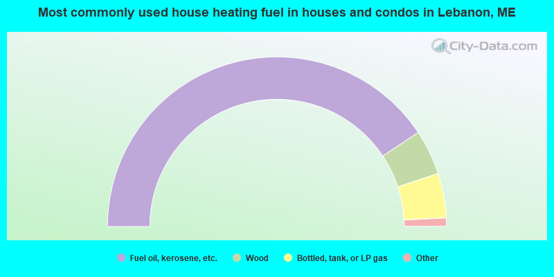
- 81.4%Fuel oil, kerosene, etc.
- 8.6%Wood
- 8.5%Bottled, tank, or LP gas
- 1.2%Coal or coke
- 0.4%Utility gas
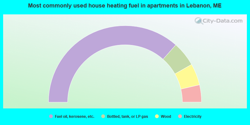
- 73.1%Fuel oil, kerosene, etc.
- 10.5%Bottled, tank, or LP gas
- 9.1%Wood
- 7.3%Electricity
Lebanon compared to Maine state average:
- Unemployed percentage significantly below state average.
- Black race population percentage significantly below state average.
- Hispanic race population percentage below state average.
- Renting percentage significantly below state average.
- Length of stay since moving in significantly above state average.
- Number of rooms per house significantly below state average.
- House age significantly below state average.
- Percentage of population with a bachelor's degree or higher significantly below state average.
Lebanon on our top lists:
- #1 on the list of "Top 101 cities with largest percentage of females in occupations: printing workers (population 5,000+)"
- #4 on the list of "Top 101 cities with largest percentage of females in industries: leather and allied products (population 5,000+)"
- #4 on the list of "Top 101 cities with largest percentage of males in industries: used merchandise, gift, novelty, and souvenir, and other miscellaneous stores (population 5,000+)"
- #11 on the list of "Top 101 cities with largest percentage of males in industries: private households (population 5,000+)"
- #12 on the list of "Top 101 cities with largest percentage of females in industries: fuel dealers (population 5,000+)"
- #15 on the list of "Top 101 cities with largest percentage of males in industries: hardware, plumbing and heating equipment, and supplies merchant wholesalers (population 5,000+)"
- #21 on the list of "Top 101 cities with largest percentage of males in industries: leather and allied products (population 5,000+)"
- #23 on the list of "Top 101 cities with largest percentage of females in occupations: material recording, scheduling, dispatching, and distributing workers (population 5,000+)"
- #24 on the list of "Top 101 cities with largest percentage of males in industries: furniture and related product manufacturing (population 5,000+)"
- #26 on the list of "Top 101 cities with largest percentage of females in occupations: communications equipment operators (population 5,000+)"
- #27 on the list of "Top 101 cities with largest percentage of females in industries: printing and related support activities (population 5,000+)"
- #34 on the list of "Top 101 cities with largest percentage of females in industries: transportation equipment (population 5,000+)"
- #39 on the list of "Top 101 cities with largest percentage of males in occupations: painters and paperhangers (population 5,000+)"
- #40 on the list of "Top 101 cities with largest percentage of males in industries: air transportation (population 5,000+)"
- #44 on the list of "Top 101 cities with largest percentage of males in industries: furniture and home furnishing merchant wholesalers (population 5,000+)"
- #44 on the list of "Top 101 cities with largest percentage of females in industries: lumber and other construction materials merchant wholesalers (population 5,000+)"
- #46 on the list of "Top 101 cities with largest percentage of males in occupations: child care workers (population 5,000+)"
- #47 on the list of "Top 101 cities with largest percentage of females in industries: miscellaneous durable goods merchant wholesalers (population 5,000+)"
- #48 on the list of "Top 101 cities with largest percentage of males in occupations: other production occupations including supervisors (population 5,000+)"
- #53 on the list of "Top 101 cities with largest percentage of males in industries: sporting goods, camera, and hobby and toy stores (population 5,000+)"
- #70 (04027) on the list of "Top 101 zip codes with the largest percentage of French Canadian first ancestries (pop 5,000+)"
- #21 on the list of "Top 101 counties with the highest percentage of residents that smoked 100+ cigarettes in their lives"
- #35 on the list of "Top 101 counties with the lowest number of births per 1000 residents 2007-2013"
- #70 on the list of "Top 101 counties with the highest percentage of residents that keep firearms around their homes"
- #77 on the list of "Top 101 counties with the best general health status score of residents (1-5), 3 years of data"

|
Total of 4 patent applications in 2008-2024.