Linwood, Wisconsin
Submit your own pictures of this town and show them to the world
- OSM Map
- Google Map
- MSN Map
Population change since 2000: +0.9%
 |
| Males: 560 | |
| Females: 561 |
| Median resident age: | 44.1 years |
| Wisconsin median age: | 42.6 years |
Zip codes: 54481.
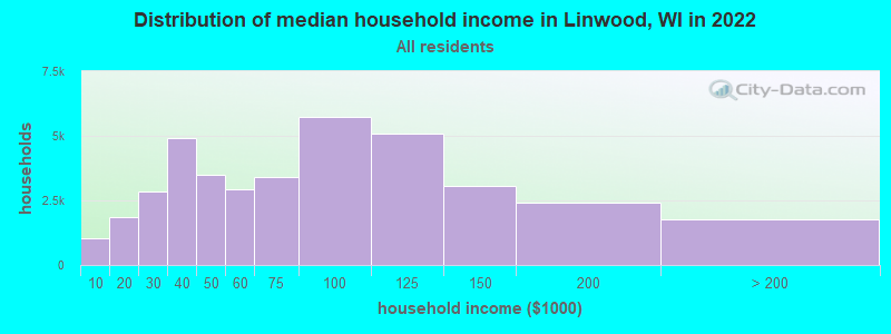
| Linwood: | $90,175 |
| WI: | $70,996 |
Estimated per capita income in 2022: $39,122 (it was $21,073 in 2000)
Linwood town income, earnings, and wages data
Estimated median house or condo value in 2022: $268,877 (it was $114,500 in 2000)
| Linwood: | $268,877 |
| WI: | $252,800 |
Mean prices in 2022: all housing units: $261,389; detached houses: $273,410; townhouses or other attached units: $220,785; in 2-unit structures: $167,787; in 5-or-more-unit structures: $469,515; mobile homes: $39,954
Detailed information about poverty and poor residents in Linwood, WI
Compare current foreclosures near Linwood, WI:
| Photo | Address | Area | Beds / Baths | Price | Details |
|---|---|---|---|---|---|

|
#1
Washington St
Wisconsin Rapids, WI 54494
|
1,917 sq. feet
|
1 baths 3 beds |
$179,900
|
show details |

|
#2
80th St S
Wisconsin Rapids, WI 54494
|
- sq. feet
|
1 baths 3 beds |
show details | |

|
#3
Tommys Tpke
Plover, WI 54467
|
1,030 sq. feet
|
1 baths 3 beds |
show details | |

|
#4
Clark St
Wisconsin Rapids, WI 54495
|
- sq. feet
|
2 baths 3 beds |
show details | |

|
#5
Bridlewood Dr
Plover, WI 54467
|
- sq. feet
|
- baths - beds |
show details | |

|
#6
32nd St S
Wisconsin Rapids, WI 54494
|
- sq. feet
|
- baths - beds |
show details | |

|
#7
Poplar Ave
Plover, WI 54467
|
- sq. feet
|
- baths - beds |
show details | |

|
#8
N 2nd Dr, Trlr 601
Stevens Point, WI 54482
|
- sq. feet
|
- baths - beds |
show details | |

|
#9
Pleasant Dr, Apt 4
Plover, WI 54467
|
- sq. feet
|
- baths - beds |
show details | |

|
#10
Hayes Ave, Trlr 26
Plover, WI 54467
|
- sq. feet
|
- baths - beds |
show details |
| Photo | Address | Area | Beds / Baths | Price | Details |
|---|---|---|---|---|---|

|
#11
Sampson St
Wisconsin Rapids, WI 54494
|
- sq. feet
|
- baths - beds |
show details | |

|
#12
Leahy Ave Apt 2
Stevens Point, WI 54481
|
- sq. feet
|
- baths - beds |
show details | |

|
#13
5th Ave N
Junction City, WI 54443
|
- sq. feet
|
- baths - beds |
show details | |

|
#14
16th St N
Wisconsin Rapids, WI 54494
|
- sq. feet
|
- baths - beds |
show details | |

|
#15
1st St N Apt 201
Wisconsin Rapids, WI 54494
|
- sq. feet
|
- baths - beds |
show details | |

|
#16
14th St N
Wisconsin Rapids, WI 54494
|
- sq. feet
|
- baths - beds |
show details | |

|
#17
14th St S # 12
Wisconsin Rapids, WI 54494
|
- sq. feet
|
- baths - beds |
show details | |

|
#18
Leahy Ave
Stevens Point, WI 54481
|
- sq. feet
|
- baths - beds |
show details | |

|
#19
Pepper Ave
Wisconsin Rapids, WI 54494
|
- sq. feet
|
- baths - beds |
show details | |

|
#20
Minnesota Ave
Stevens Point, WI 54481
|
- sq. feet
|
- baths - beds |
show details |
| Photo | Address | Area | Beds / Baths | Price | Details |
|---|---|---|---|---|---|

|
#21
3rd Ave S
Wisconsin Rapids, WI 54495
|
- sq. feet
|
- baths - beds |
show details | |

|
#22
Prairie St
Stevens Point, WI 54481
|
- sq. feet
|
- baths - beds |
show details | |

|
#23
Water St Apt 37
Stevens Point, WI 54481
|
- sq. feet
|
- baths - beds |
show details | |

|
#24
Prentice St N Apt 31
Stevens Point, WI 54481
|
- sq. feet
|
- baths - beds |
show details | |

|
#25
Johns Dr Apt 9
Stevens Point, WI 54481
|
- sq. feet
|
- baths - beds |
show details | |

|
#26
Hoffman Dr
Plover, WI 54467
|
- sq. feet
|
- baths - beds |
show details | |

|
#27
Sampson St
Wisconsin Rapids, WI 54494
|
- sq. feet
|
- baths - beds |
show details | |

|
#28
Pine Haven Ct
Wisconsin Rapids, WI 54494
|
- sq. feet
|
- baths - beds |
show details | |

|
#29
Brentwood Dr
Port Edwards, WI 54469
|
- sq. feet
|
- baths - beds |
show details | |

|
#30
Badger Ave
Wisconsin Rapids, WI 54494
|
- sq. feet
|
- baths - beds |
show details |
| Photo | Address | Area | Beds / Baths | Price | Details |
|---|---|---|---|---|---|

|
#31
Gaynor Ave
Wisconsin Rapids, WI 54495
|
- sq. feet
|
- baths - beds |
show details | |

|
#32
4th St S
Wisconsin Rapids, WI 54494
|
- sq. feet
|
- baths - beds |
show details | |

|
#33
Airport Ave
Wisconsin Rapids, WI 54494
|
- sq. feet
|
- baths - beds |
show details | |

|
#34
Lavigne Ave
Port Edwards, WI 54469
|
- sq. feet
|
- baths - beds |
show details | |

|
#35
County Rd W
Bancroft, WI 54921
|
- sq. feet
|
- baths - beds |
show details | |

|
#36
28th St S
Wisconsin Rapids, WI 54494
|
- sq. feet
|
- baths - beds |
show details | |

|
#37
Church Ave
Wisconsin Rapids, WI 54494
|
- sq. feet
|
- baths - beds |
show details | |

|
#38
24th Ave S
Wisconsin Rapids, WI 54495
|
- sq. feet
|
- baths - beds |
show details | |

|
#39
Thalacker Ave
Wisconsin Rapids, WI 54494
|
- sq. feet
|
- baths - beds |
show details | |

|
#40
22nd St N
Wisconsin Rapids, WI 54494
|
- sq. feet
|
- baths - beds |
show details |
| Photo | Address | Area | Beds / Baths | Price | Details |
|---|---|---|---|---|---|

|
#41
13th Ave N
Wisconsin Rapids, WI 54495
|
- sq. feet
|
- baths - beds |
show details | |

|
#42
Wisconsin Ave
Plover, WI 54467
|
- sq. feet
|
- baths - beds |
show details | |

|
#43
Strongs Ave
Stevens Point, WI 54481
|
- sq. feet
|
- baths - beds |
show details | |

|
#44
Illinois Ave
Stevens Point, WI 54481
|
- sq. feet
|
- baths - beds |
show details | |

|
#45
Briggs St
Stevens Point, WI 54481
|
- sq. feet
|
- baths - beds |
show details | |

|
#46
Tommys Tpke
Stevens Point, WI 54481
|
- sq. feet
|
- baths - beds |
show details | |

|
#47
Acorn St
Stevens Point, WI 54481
|
- sq. feet
|
- baths - beds |
show details | |

|
#48
Nebel St
Stevens Point, WI 54481
|
- sq. feet
|
- baths - beds |
show details | |

|
#49
Chestnut Dr
Plover, WI 54467
|
- sq. feet
|
- baths - beds |
show details | |

|
Check over 1 million property listings on Foreclosure.com!
|
browse all offers | |||

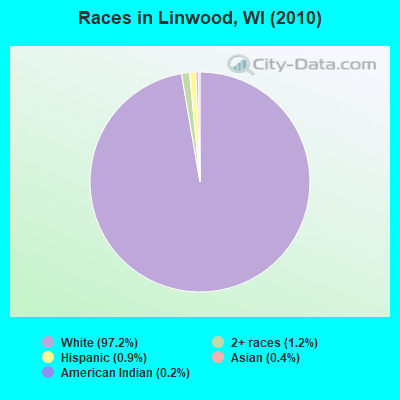
- 1,09097.2%White alone
- 141.2%Two or more races
- 100.9%Hispanic
- 50.4%Asian alone
- 20.2%American Indian alone
Races in Linwood detailed stats: ancestries, foreign born residents, place of birth
 Recent articles from our blog. Our writers, many of them Ph.D. graduates or candidates, create easy-to-read articles on a wide variety of topics.

Ancestries: Polish (57.8%), German (42.2%), English (8.2%), Irish (5.9%), Norwegian (3.6%), United States (2.6%).
Current Local Time: CST time zone
Land area: 31.9 square miles.
Population density: 35 people per square mile (very low).
1 resident is foreign born
| This town: | 0.1% |
| Wisconsin: | 3.6% |
| Linwood town: | 1.5% ($1,732) |
| Wisconsin: | 2.0% ($2,245) |
Nearest city with pop. 50,000+: Oshkosh, WI  (62.8 miles , pop. 62,916).
Nearest city with pop. 200,000+: Madison, WI (98.6 miles , pop. 208,054).
Nearest city with pop. 1,000,000+: Chicago, IL (208.2 miles , pop. 2,896,016).
Nearest cities:
), ), ), ), )Latitude: 44.49 N, Longitude: 89.64 W
Area code commonly used in this area: 715
| Here: | 2.7% |
| Wisconsin: | 2.7% |
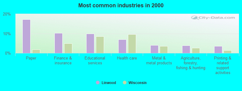
- Paper (17.3%)
- Finance & insurance (10.2%)
- Educational services (9.9%)
- Health care (6.9%)
- Metal & metal products (4.0%)
- Agriculture, forestry, fishing & hunting (3.9%)
- Printing & related support activities (3.5%)
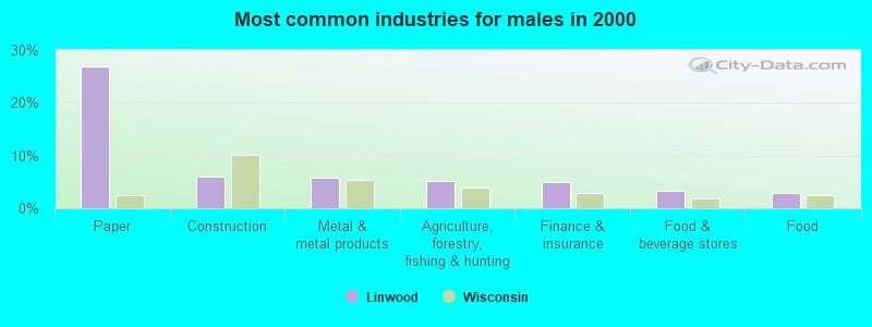
- Paper (27.0%)
- Construction (6.0%)
- Metal & metal products (5.7%)
- Agriculture, forestry, fishing & hunting (5.2%)
- Finance & insurance (4.9%)
- Food & beverage stores (3.3%)
- Food (3.0%)
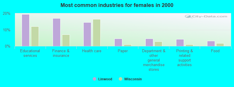
- Educational services (19.5%)
- Finance & insurance (17.0%)
- Health care (14.5%)
- Paper (4.6%)
- Department & other general merchandise stores (4.6%)
- Printing & related support activities (4.3%)
- Food (3.2%)
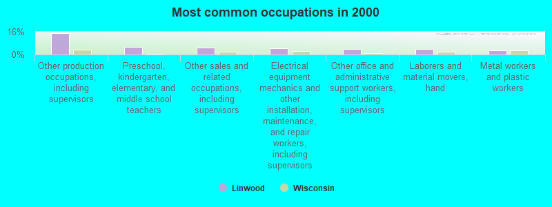
- Other production occupations, including supervisors (15.3%)
- Preschool, kindergarten, elementary, and middle school teachers (5.4%)
- Other sales and related occupations, including supervisors (5.1%)
- Electrical equipment mechanics and other installation, maintenance, and repair workers, including supervisors (4.2%)
- Other office and administrative support workers, including supervisors (3.9%)
- Laborers and material movers, hand (3.7%)
- Metal workers and plastic workers (3.1%)
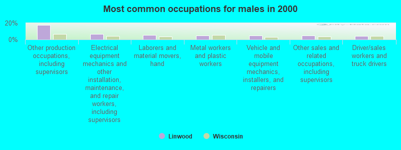
- Other production occupations, including supervisors (17.4%)
- Electrical equipment mechanics and other installation, maintenance, and repair workers, including supervisors (6.5%)
- Laborers and material movers, hand (5.7%)
- Metal workers and plastic workers (4.6%)
- Vehicle and mobile equipment mechanics, installers, and repairers (4.6%)
- Other sales and related occupations, including supervisors (4.6%)
- Driver/sales workers and truck drivers (4.1%)
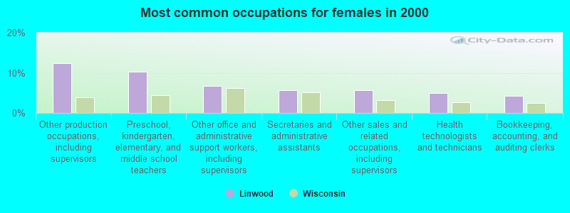
- Other production occupations, including supervisors (12.4%)
- Preschool, kindergarten, elementary, and middle school teachers (10.3%)
- Other office and administrative support workers, including supervisors (6.7%)
- Secretaries and administrative assistants (5.7%)
- Other sales and related occupations, including supervisors (5.7%)
- Health technologists and technicians (5.0%)
- Bookkeeping, accounting, and auditing clerks (4.3%)
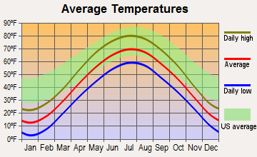
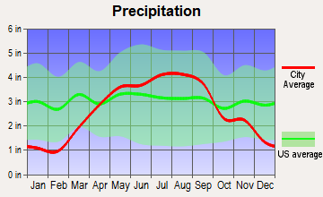
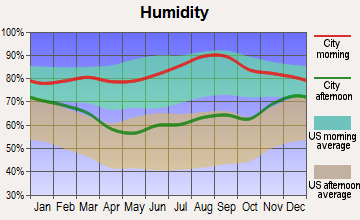
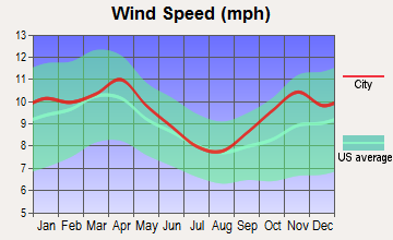
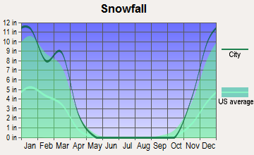
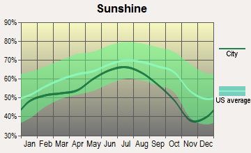
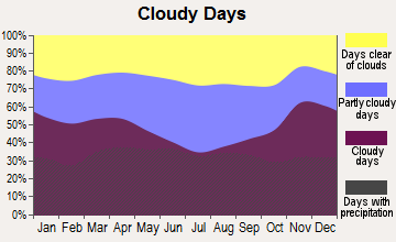
Average climate in Linwood, Wisconsin
Based on data reported by over 4,000 weather stations
(lower is better)
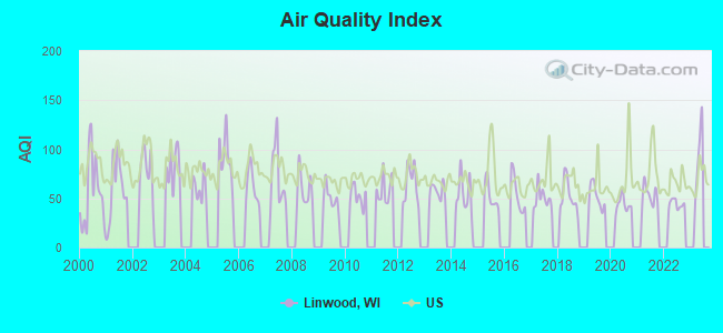
Air Quality Index (AQI) level in 2022 was 44.1. This is significantly better than average.
| City: | 44.1 |
| U.S.: | 72.6 |
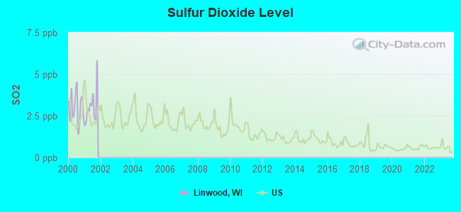
Sulfur Dioxide (SO2) [ppb] level in 2001 was 3.05. This is significantly worse than average. Closest monitor was 3.2 miles away from the city center.
| City: | 3.05 |
| U.S.: | 1.51 |
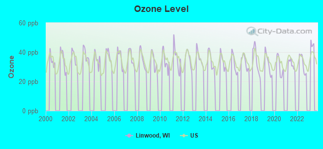
Ozone [ppb] level in 2022 was 32.1. This is about average. Closest monitor was 6.5 miles away from the city center.
| City: | 32.1 |
| U.S.: | 33.3 |
Tornado activity:
Linwood-area historical tornado activity is near Wisconsin state average. It is 24% greater than the overall U.S. average.
On 9/26/1951, a category F4 (max. wind speeds 207-260 mph) tornado 20.1 miles away from the Linwood town center killed 6 people and injured 3 people and caused between $50,000 and $500,000 in damages.
On 4/19/1957, a category F4 tornado 31.0 miles away from the town center killed one person and caused between $5000 and $50,000 in damages.
Earthquake activity:
Linwood-area historical earthquake activity is significantly above Wisconsin state average. It is 1% greater than the overall U.S. average.On 6/28/2004 at 06:10:52, a magnitude 4.2 (4.2 MW, Depth: 6.2 mi, Class: Light, Intensity: IV - V) earthquake occurred 212.8 miles away from the city center
On 4/18/2008 at 09:36:59, a magnitude 5.4 (5.1 MB, 4.8 MS, 5.4 MW, 5.2 MW, Class: Moderate, Intensity: VI - VII) earthquake occurred 427.3 miles away from Linwood center
On 6/10/1987 at 23:48:54, a magnitude 5.1 (4.9 MB, 4.4 MS, 4.6 MS, 5.1 LG) earthquake occurred 402.4 miles away from Linwood center
On 7/9/1975 at 14:54:15, a magnitude 4.6 (4.6 MB) earthquake occurred 323.0 miles away from Linwood center
On 2/10/2010 at 09:59:35, a magnitude 3.8 (3.8 MW, Depth: 6.2 mi, Class: Light, Intensity: II - III) earthquake occurred 183.6 miles away from Linwood center
On 4/18/2008 at 09:36:59, a magnitude 5.2 (5.2 MW, Depth: 8.9 mi) earthquake occurred 427.4 miles away from the city center
Magnitude types: regional Lg-wave magnitude (LG), body-wave magnitude (MB), surface-wave magnitude (MS), moment magnitude (MW)
Natural disasters:
The number of natural disasters in Portage County (11) is smaller than the US average (15).Major Disasters (Presidential) Declared: 8
Emergencies Declared: 2
Causes of natural disasters: Floods: 8, Storms: 7, Tornadoes: 3, Drought: 1, Hurricane: 1, Wind: 1, Other: 1 (Note: some incidents may be assigned to more than one category).
Hospitals and medical centers near Linwood:
- STEVENS POINT CARE CENTER (Nursing Home, about 3 miles away; STEVENS POINT, WI)
- PORTAGE CTY HLTH CARE CTR (Nursing Home, about 4 miles away; STEVENS POINT, WI)
- MINISTRY HC HSPC STEVENS POINT (Hospital, about 5 miles away; STEVENS POINT, WI)
- DAVITA - STEVENS POINT DIALYSIS (Dialysis Facility, about 5 miles away; STEVENS POINT, WI)
- MINISTRY ST MICHAELS HOSPITAL OF STEVENS POINT Acute Care Hospitals (about 5 miles away; STEVENS POINT, WI)
- STRAWBERRY LANE MEDICAL AND REHAB (Nursing Home, about 10 miles away; WISCONSIN RAPIDS, WI)
- WISCONSIN RAPIDS NURSING AND REHABILITATION CENTER (Nursing Home, about 12 miles away; WISCONSIN RAPIDS, WI)
Colleges/universities with over 2000 students nearest to Linwood:
- University of Wisconsin-Stevens Point (about 5 miles; Stevens Point, WI; Full-time enrollment: 9,089)
- Mid-State Technical College (about 10 miles; Wisconsin Rapids, WI; FT enrollment: 2,128)
- Northcentral Technical College (about 35 miles; Wausau, WI; FT enrollment: 3,356)
- Fox Valley Technical College (about 61 miles; Appleton, WI; FT enrollment: 5,682)
- University of Wisconsin-Oshkosh (about 63 miles; Oshkosh, WI; FT enrollment: 10,637)
- Lawrence University (about 64 miles; Appleton, WI; FT enrollment: 2,821)
- Northeast Wisconsin Technical College (about 76 miles; Green Bay, WI; FT enrollment: 6,069)
Points of interest:
Notable locations in Linwood: Wisconsin River Country Club (A), Rudolph Volunteer Fire Department Station 2 Town of Linwood (B). Display/hide their locations on the map
Cemetery: Linwood Union Cemetery (1). Display/hide its location on the map
Swamps: Bear Creek Marsh (A). Display/hide its location on the map
Streams, rivers, and creeks: Bear Creek (A), Mill Creek (B), Rocky Run (C). Display/hide their locations on the map
Parks in Linwood include: Al Tech County Park (1), Consolidated County Park (2). Display/hide their locations on the map
| This town: | 2.6 people |
| Wisconsin: | 2.4 people |
| This town: | 78.4% |
| Whole state: | 64.4% |
| This town: | 4.9% |
| Whole state: | 7.3% |
Likely homosexual households (counted as self-reported same-sex unmarried-partner households)
- Lesbian couples: 0.2% of all households
- Gay men: 0.0% of all households
| This town: | 3.0% |
| Whole state: | 8.7% |
| This town: | 0.5% |
| Whole state: | 3.7% |
For population 15 years and over in Linwood:
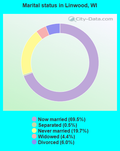
- Never married: 19.7%
- Now married: 69.5%
- Separated: 0.5%
- Widowed: 4.4%
- Divorced: 6.0%
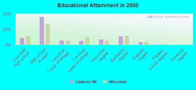
For population 25 years and over in Linwood:
- High school or higher: 88.5%
- Bachelor's degree or higher: 19.6%
- Graduate or professional degree: 5.6%
- Unemployed: 2.8%
- Mean travel time to work (commute): 21.3 minutes
| Here: | 10.3 |
| Wisconsin average: | 11.0 |
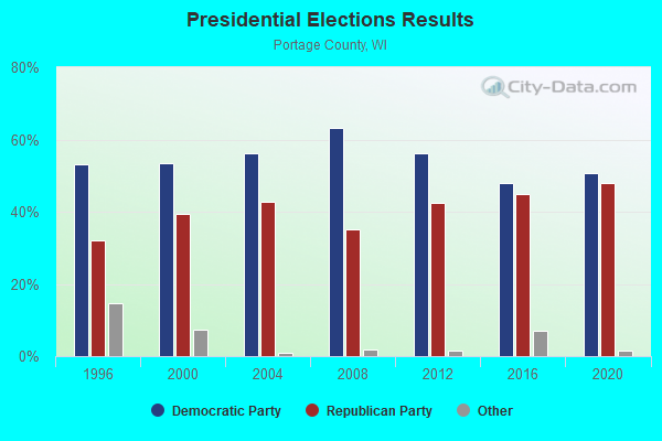
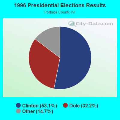
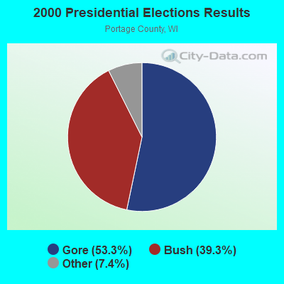
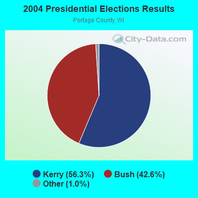
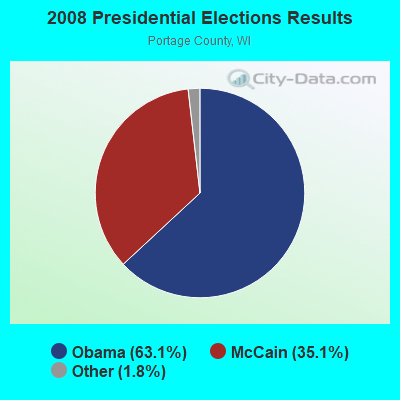
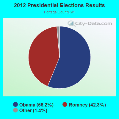
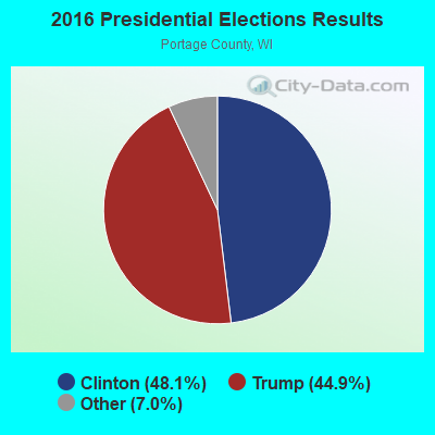
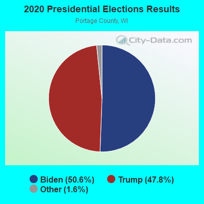
Graphs represent county-level data. Detailed 2008 Election Results
Religion statistics for Linwood, WI (based on Portage County data)

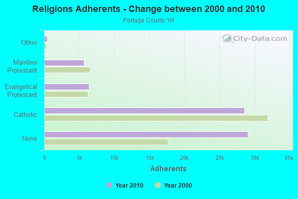
| Religion | Adherents | Congregations |
|---|---|---|
| Catholic | 28,520 | 16 |
| Evangelical Protestant | 6,390 | 35 |
| Mainline Protestant | 5,687 | 17 |
| Other | 392 | 6 |
| None | 29,030 | - |
Food Environment Statistics:
| Portage County: | 1.17 / 10,000 pop. |
| State: | 1.86 / 10,000 pop. |
| Portage County: | 3.51 / 10,000 pop. |
| Wisconsin: | 4.12 / 10,000 pop. |
| Portage County: | 9.81 / 10,000 pop. |
| Wisconsin: | 8.64 / 10,000 pop. |
| This county: | 6.9% |
| Wisconsin: | 7.6% |
| This county: | 28.1% |
| Wisconsin: | 27.5% |
| Portage County: | 11.6% |
| Wisconsin: | 13.0% |
Strongest AM radio stations in Linwood:
- WSPT (1010 AM; 50 kW; STEVENS POINT, WI)
- WSAU (550 AM; 20 kW; WAUSAU, WI; Owner: WRIG, INC.)
- WFHR (1320 AM; 5 kW; WISCONSIN RAPIDS, WI; Owner: WISCONSIN RAPIDS BROADCASTING, LLC)
- WLBL (930 AM; 5 kW; AUBURNDALE, WI; Owner: STATE OF WISCONSIN - EDUCATIONAL COMMUNICATIONS BOARD)
- WNAM (1280 AM; 50 kW; NEENAH-MENASHA, WI; Owner: CUMULUS LICENSING CORP.)
- WRIG (1390 AM; 10 kW; SCHOFIELD, WI; Owner: WRIG, INC.)
- WDUX (800 AM; 5 kW; WAUPACA, WI; Owner: LAIRD BROADCASTING COMPANY, INC.)
- WHBY (1150 AM; 25 kW; KIMBERLY, WI; Owner: WOODWARD COMMUNICATIONS, INC.)
- WTMJ (620 AM; 50 kW; MILWAUKEE, WI; Owner: JOURNAL BROADCAST CORPORATION)
- WEBC (560 AM; 50 kW; DULUTH, MN)
- WISN (1130 AM; 50 kW; MILWAUKEE, WI; Owner: CAPSTAR TX LIMITED PARTNERSHIP)
- WSCR (670 AM; 50 kW; CHICAGO, IL; Owner: INFINITY BROADCASTING OPERATIONS, INC.)
- WGN (720 AM; 50 kW; CHICAGO, IL; Owner: WGN CONTINENTAL BROADCASTING CO.)
Strongest FM radio stations in Linwood:
- WYTE (96.7 FM; WHITING, WI; Owner: NEWRADIO GROUP, LLC)
- WSPT-FM (97.9 FM; STEVENS POINT, WI; Owner: AMERICUS COMMUNICATIONS, LLC)
- WWSP (89.9 FM; STEVENS POINT, WI; Owner: BD. OF REGENTS OF UNIV. OF WISCONSIN)
- WGLX-FM (103.3 FM; WISCONSIN RAPIDS, WI; Owner: WISCONSIN RAPIDS BROADCASTING, LLC)
- WLJY (106.5 FM; MARSHFIELD, WI; Owner: NEWRADIO GROUP, LLC)
- WIZD (99.9 FM; RUDOLPH, WI; Owner: WRIG, INC)
- WGNV (88.5 FM; MILLADORE, WI; Owner: EVANGEL MINISTRIES, INC.)
- WHRM (90.9 FM; WAUSAU, WI; Owner: STATE OF WISCONSIN - EDUCATIONAL COMMUNICATIONS BOARD)
- WIFC (95.5 FM; WAUSAU, WI; Owner: WRIG, INC.)
- WDEZ (101.9 FM; WAUSAU, WI; Owner: W R I G, INC.)
- WLBL-FM (91.9 FM; WAUSAU, WI; Owner: STATE OF WISCONSIN - EDUCATIONAL COMMUNICATIONS BOARD)
- WXPW (91.9 FM; WAUSAU, WI; Owner: WHITE PINE COMMUNITY BROADCASTING, INC)
- WYCO (107.9 FM; WAUSAU, WI; Owner: SEEHAFER BROADCASTING CORPORATION)
- WMMA (93.9 FM; NEKOOSA, WI; Owner: STARBOARD BROADCASTING, INC.)
- WCLQ (89.5 FM; WAUSAU, WI; Owner: CHRISTIAN LIFE COMMUNICATIONS, INC.)
- WKQH (104.9 FM; MARATHON, WI; Owner: RLM COMMUNICATIONS, INC)
TV broadcast stations around Linwood:
- W24BV (Channel 24; WHITING, WI; Owner: MS COMMUNICATIONS, LLC)
- W60CI (Channel 60; WHITING, WI; Owner: MS COMMUNICATIONS, LLC)
- W16AY (Channel 16; WHITING, WI; Owner: MS COMMUNICATIONS, LLC)
- W18CS (Channel 18; WHITING, WI; Owner: MS COMMUNICATIONS, LLC)
- W40BC (Channel 40; WHITING, WI; Owner: MS COMMUNICATIONS, LLC)
- W62DA (Channel 62; WHITING, WI; Owner: MS COMMUNICATIONS, LLC)
- W06BU (Channel 6; WHITING, WI; Owner: MS COMMUNICATIONS, LLC)
- WAOW-TV (Channel 9; WAUSAU, WI; Owner: WAOW-WYOW TELEVISION, INC.)
- WSAW-TV (Channel 7; WAUSAU, WI; Owner: GRAY MIDAMERICA TV LICENSEE CORP.)
- WFXS (Channel 55; WITTENBERG, WI; Owner: DAVIS TELEVISION WAUSAU, LLC)
- WHRM-TV (Channel 20; WAUSAU, WI; Owner: STATE OF WISCONSIN - EDUCATIONAL COMMUNICATIONS BOARD)
- National Bridge Inventory (NBI) Statistics
- 8Number of bridges
- 98ft / 30.1mTotal length
- $227,000Total costs
- 16,100Total average daily traffic
- 365Total average daily truck traffic
- 20,168Total future (year 2037) average daily traffic
FCC Registered Microwave Towers:
2- MinchTowerSW, Lat: 44.472972 Lon: -89.665806, Type: Ltower, Structure height: 42 m, Call Sign: WQQH694,
Assigned Frequencies: 3650.00 MHz, Grant Date: 12/14/2012, Expiration Date: 12/14/2022, Cancellation Date: 01/03/2023, Certifier: Chad Austreng, Registrant: Digital Complex, Inc., 3700 Corporate Ave, Plover, WI 54467, Phone: (715) 347-3696, Email:
- MinchTowerSE, Lat: 44.472972 Lon: -89.665806, Type: Ltower, Structure height: 42 m, Call Sign: WQQH694,
Assigned Frequencies: 3650.00 MHz, Grant Date: 12/14/2012, Expiration Date: 12/14/2022, Cancellation Date: 01/03/2023, Certifier: Chad Austreng, Registrant: Digital Complex, Inc., 3700 Corporate Ave, Plover, WI 54467, Phone: (715) 347-3696, Email:
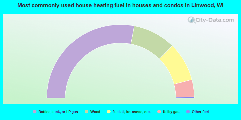
- 56.0%Bottled, tank, or LP gas
- 18.8%Wood
- 17.1%Fuel oil, kerosene, etc.
- 7.6%Utility gas
- 0.5%Other fuel
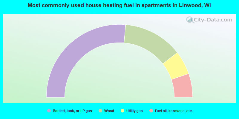
- 52.6%Bottled, tank, or LP gas
- 26.3%Wood
- 10.5%Utility gas
- 10.5%Fuel oil, kerosene, etc.
Linwood compared to Wisconsin state average:
- Unemployed percentage significantly below state average.
- Black race population percentage significantly below state average.
- Hispanic race population percentage significantly below state average.
- Foreign-born population percentage significantly below state average.
- Renting percentage significantly below state average.
- Length of stay since moving in significantly above state average.
- Number of rooms per house significantly below state average.
- House age significantly below state average.