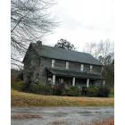
Logan, Alabama

Submit your own pictures of this place and show them to the world
- OSM Map
- General Map
- Google Map
- MSN Map

| Males: 1,877 | |
| Females: 1,817 |
| Median resident age: | 35.2 years |
| Alabama median age: | 35.8 years |
Zip code: 35057
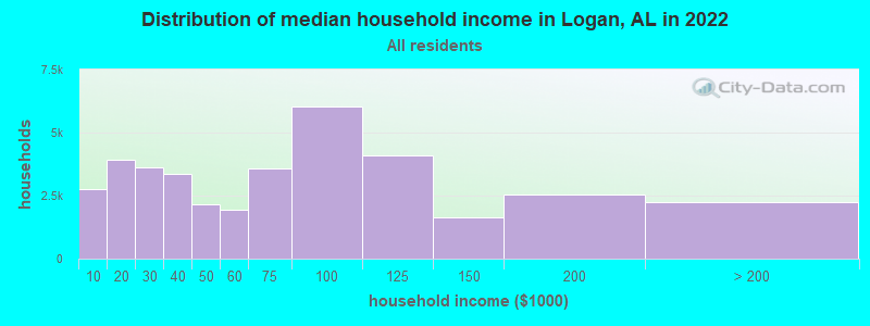
| Logan: | $66,489 |
| AL: | $59,674 |
Estimated per capita income in 2022: $31,909 (it was $16,775 in 2000)
Logan CCD income, earnings, and wages data
Estimated median house or condo value in 2022: $191,836 (it was $81,800 in 2000)
| Logan: | $191,836 |
| AL: | $200,900 |
Mean prices in 2022: all housing units: $206,968; detached houses: $237,907; townhouses or other attached units: $214,311; in 2-unit structures: $134,611; in 5-or-more-unit structures: $302,652; mobile homes: $75,346; occupied boats, rvs, vans, etc.: $99,714
Detailed information about poverty and poor residents in Logan, AL
Compare current foreclosures near Logan, AL:
| Photo | Address | Area | Beds / Baths | Price | Details |
|---|---|---|---|---|---|

|
#1
County Road 818
Logan, AL 35098
|
1,725 sq. feet
|
- baths - beds |
show details | |

|
#2
County Road 810
Logan, AL 35098
|
- sq. feet
|
- baths - beds |
show details | |

|
#3
County Road 831
Logan, AL 35098
|
- sq. feet
|
- baths - beds |
show details | |

|
#4
Rutledge Dr
Jasper, AL 35504
|
2,156 sq. feet
|
2 baths 3 beds |
$352,000
|
show details |

|
#5
Scott Dr
Cullman, AL 35055
|
1,744 sq. feet
|
2 baths 2 beds |
$285,000
|
show details |

|
#6
Calvert Rd
Cullman, AL 35057
|
2,078 sq. feet
|
3 baths 3 beds |
show details | |

|
#7
Wilhite Rd
Falkville, AL 35622
|
1,451 sq. feet
|
2 baths 3 beds |
show details | |

|
#8
Cleveland Ave SW
Cullman, AL 35055
|
1,197 sq. feet
|
1 baths - beds |
show details | |

|
#9
Nance Ford Rd
Hartselle, AL 35640
|
- sq. feet
|
2 baths 4 beds |
show details | |

|
#10
County Road 1542
Eva, AL 35621
|
3,084 sq. feet
|
1 baths - beds |
show details |
| Photo | Address | Area | Beds / Baths | Price | Details |
|---|---|---|---|---|---|

|
#11
Maple Dr NW
Cullman, AL 35055
|
2,023 sq. feet
|
1 baths - beds |
show details | |

|
#12
County Road 497
Cullman, AL 35055
|
1,812 sq. feet
|
1 baths - beds |
show details | |

|
#13
County Road 622
Hanceville, AL 35077
|
1,806 sq. feet
|
1 baths - beds |
show details | |

|
#14
County Road 111
Bremen, AL 35033
|
2,074 sq. feet
|
1 baths - beds |
show details | |

|
#15
County Road 1338
Vinemont, AL 35179
|
2,244 sq. feet
|
1 baths - beds |
show details | |

|
#16
County Road 623
Cullman, AL 35055
|
1,356 sq. feet
|
1 baths - beds |
show details | |

|
#17
County Road 1403
Cullman, AL 35058
|
1,752 sq. feet
|
1 baths - beds |
show details | |

|
#18
County Road 1223
Vinemont, AL 35179
|
1,568 sq. feet
|
1 baths - beds |
show details | |

|
#19
County Road 265
Cullman, AL 35057
|
1,634 sq. feet
|
1 baths - beds |
show details | |

|
#20
County Road 1386
Falkville, AL 35622
|
1,802 sq. feet
|
1 baths - beds |
show details |
| Photo | Address | Area | Beds / Baths | Price | Details |
|---|---|---|---|---|---|

|
#21
Bolte Rd SE
Cullman, AL 35055
|
3,054 sq. feet
|
1 baths - beds |
show details | |

|
#22
County Road 1242
Vinemont, AL 35179
|
1,968 sq. feet
|
1 baths - beds |
show details | |

|
#23
Oakmont Dr SE
Cullman, AL 35055
|
1,683 sq. feet
|
1 baths - beds |
show details | |

|
#24
County Road 248
Cullman, AL 35057
|
2,124 sq. feet
|
1 baths - beds |
show details | |

|
#25
Whaley Ave NE
Hanceville, AL 35077
|
870 sq. feet
|
1 baths - beds |
show details | |

|
#26
Hopewell Rd NE
Hanceville, AL 35077
|
2,711 sq. feet
|
1 baths - beds |
show details | |

|
#27
Nance Ford Rd
Hartselle, AL 35640
|
1,890 sq. feet
|
1 baths - beds |
show details | |

|
#28
County Road 1541
Cullman, AL 35058
|
1,878 sq. feet
|
1 baths - beds |
show details | |

|
#29
County Road 3949
Arley, AL 35541
|
3,168 sq. feet
|
1 baths - beds |
show details | |

|
#30
Ryan Rd
Eva, AL 35621
|
984 sq. feet
|
1 baths - beds |
show details |
| Photo | Address | Area | Beds / Baths | Price | Details |
|---|---|---|---|---|---|

|
#31
County Road 1660
Cullman, AL 35058
|
1,346 sq. feet
|
1 baths - beds |
show details | |

|
#32
County Road 773
Cullman, AL 35055
|
7,684 sq. feet
|
2 baths - beds |
show details | |

|
#33
Summerford Orr Rd
Falkville, AL 35622
|
1,680 sq. feet
|
1 baths - beds |
show details | |

|
#34
Al Highway 91
Hanceville, AL 35077
|
2,002 sq. feet
|
1 baths - beds |
show details | |

|
#35
County Road 1490
Cullman, AL 35058
|
1,300 sq. feet
|
1 baths - beds |
show details | |

|
#36
Arkadelphia Rd NW
Hanceville, AL 35077
|
1,382 sq. feet
|
1 baths - beds |
show details | |

|
#37
Jesse Green Rd
Eva, AL 35621
|
2,210 sq. feet
|
1 baths - beds |
show details | |

|
#38
County Road 52
Arley, AL 35541
|
1,788 sq. feet
|
1 baths - beds |
show details | |

|
#39
Dean Ave NE
Hanceville, AL 35077
|
1,890 sq. feet
|
1 baths - beds |
show details | |

|
#40
County Road 54
Bremen, AL 35033
|
1,302 sq. feet
|
1 baths - beds |
show details |
| Photo | Address | Area | Beds / Baths | Price | Details |
|---|---|---|---|---|---|

|
#41
Helen Warren Vogel St NE
Hanceville, AL 35077
|
1,352 sq. feet
|
1 baths - beds |
show details | |

|
#42
Whaley Ave NE
Hanceville, AL 35077
|
870 sq. feet
|
1 baths - beds |
show details | |

|
#43
Short Dr
Cullman, AL 35057
|
1,248 sq. feet
|
1 baths - beds |
show details | |

|
#44
3rd Ave NW
Cullman, AL 35055
|
1,666 sq. feet
|
1 baths - beds |
show details | |

|
#45
Al Highway 69 N
Cullman, AL 35058
|
1,598 sq. feet
|
1 baths - beds |
show details | |

|
#46
County Road 338
Crane Hill, AL 35053
|
1,300 sq. feet
|
1 baths - beds |
show details | |

|
#47
Logan Ave SW
Cullman, AL 35055
|
1,182 sq. feet
|
1 baths - beds |
show details | |

|
#48
County Road 1210
Cullman, AL 35057
|
3,128 sq. feet
|
2 baths - beds |
show details | |

|
#49
Us Highway 278 W
Cullman, AL 35057
|
1,747 sq. feet
|
1 baths - beds |
show details | |

|
Check over 1 million property listings on Foreclosure.com!
|
browse all offers | |||

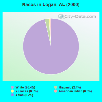
- 3,42896.4%White alone
- 842.4%Hispanic
- 170.5%American Indian alone
- 180.5%Two or more races
- 70.2%Asian alone
- 10.03%Black alone
- 10.03%Other race alone
According to our research of Alabama and other state lists, there were 8 registered sex offenders living in Logan, Alabama as of April 24, 2024.
The ratio of all residents to sex offenders in Logan is 462 to 1.
The ratio of registered sex offenders to all residents in this city is near the state average.
 Recent articles from our blog. Our writers, many of them Ph.D. graduates or candidates, create easy-to-read articles on a wide variety of topics.

Current Local Time: CST time zone
Land area: 51.4 square miles.
Population density: 72 people per square mile (very low).

| Logan CCD: | 0.2% ($199) |
| Alabama: | 0.4% ($289) |
Nearest city with pop. 50,000+: Decatur, AL  (29.3 miles , pop. 53,929).
Nearest city with pop. 200,000+: Birmingham, AL (44.6 miles , pop. 242,820).
Nearest city with pop. 1,000,000+: Chicago, IL (532.8 miles , pop. 2,896,016).
Nearest cities:
), ), ), ), ), ), )Latitude: 34.16 N, Longitude: 86.96 W

| Here: | 2.1% |
| Alabama: | 2.6% |
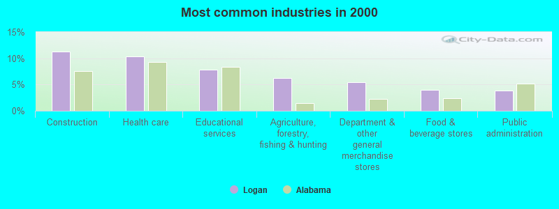
- Construction (11.3%)
- Health care (10.4%)
- Educational services (7.8%)
- Agriculture, forestry, fishing & hunting (6.2%)
- Department & other general merchandise stores (5.4%)
- Food & beverage stores (3.9%)
- Public administration (3.9%)
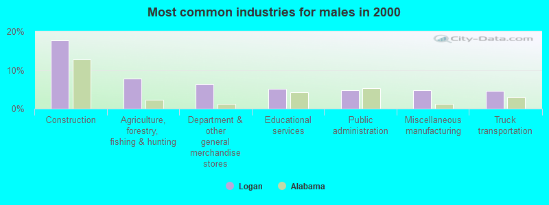
- Construction (17.7%)
- Agriculture, forestry, fishing & hunting (7.8%)
- Department & other general merchandise stores (6.3%)
- Educational services (5.1%)
- Public administration (4.8%)
- Miscellaneous manufacturing (4.7%)
- Truck transportation (4.5%)
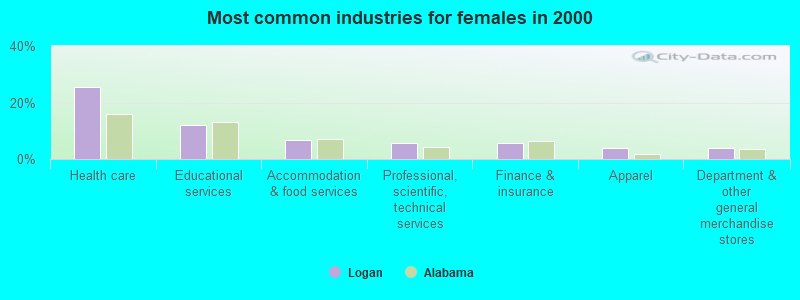
- Health care (25.4%)
- Educational services (11.9%)
- Accommodation & food services (6.8%)
- Professional, scientific, technical services (5.6%)
- Finance & insurance (5.6%)
- Apparel (4.0%)
- Department & other general merchandise stores (4.0%)
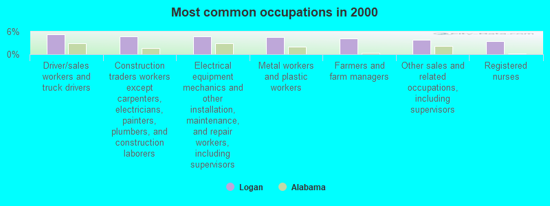
- Driver/sales workers and truck drivers (5.3%)
- Construction traders workers except carpenters, electricians, painters, plumbers, and construction laborers (4.8%)
- Electrical equipment mechanics and other installation, maintenance, and repair workers, including supervisors (4.7%)
- Metal workers and plastic workers (4.6%)
- Farmers and farm managers (4.2%)
- Other sales and related occupations, including supervisors (3.8%)
- Registered nurses (3.5%)
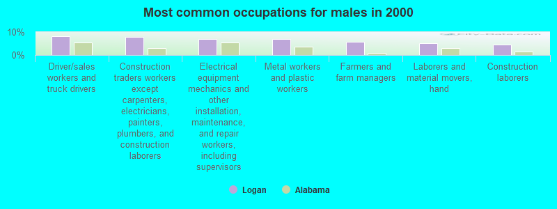
- Driver/sales workers and truck drivers (8.3%)
- Construction traders workers except carpenters, electricians, painters, plumbers, and construction laborers (7.9%)
- Electrical equipment mechanics and other installation, maintenance, and repair workers, including supervisors (7.0%)
- Metal workers and plastic workers (6.9%)
- Farmers and farm managers (5.7%)
- Laborers and material movers, hand (5.2%)
- Construction laborers (4.4%)
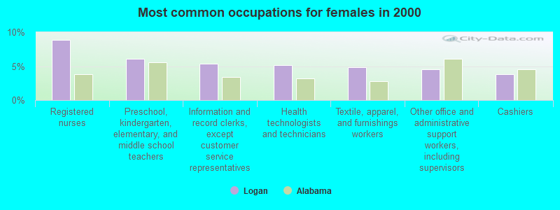
- Registered nurses (8.8%)
- Preschool, kindergarten, elementary, and middle school teachers (6.1%)
- Information and record clerks, except customer service representatives (5.3%)
- Health technologists and technicians (5.2%)
- Textile, apparel, and furnishings workers (4.9%)
- Other office and administrative support workers, including supervisors (4.6%)
- Cashiers (3.8%)
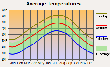
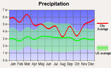
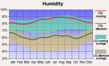
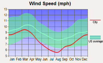
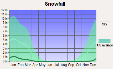
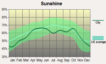
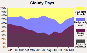
Average climate in Logan, Alabama
Based on data reported by over 4,000 weather stations
(lower is better)
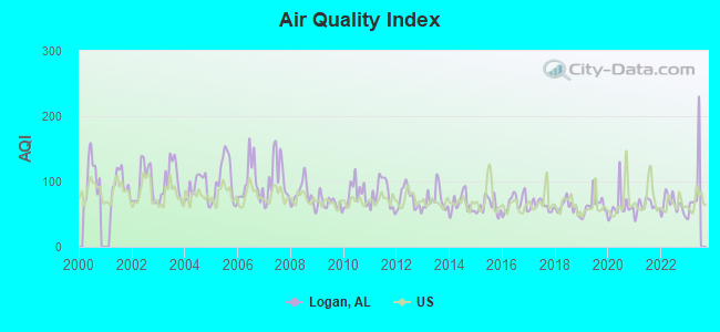
Air Quality Index (AQI) level in 2022 was 64.4. This is about average.
| City: | 64.4 |
| U.S.: | 72.6 |
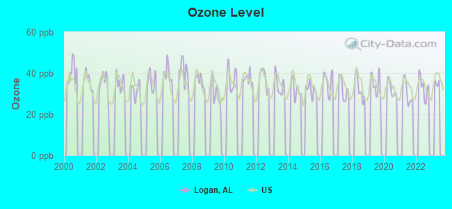
Ozone [ppb] level in 2022 was 33.3. This is about average. Closest monitor was 24.7 miles away from the city center.
| City: | 33.3 |
| U.S.: | 33.3 |
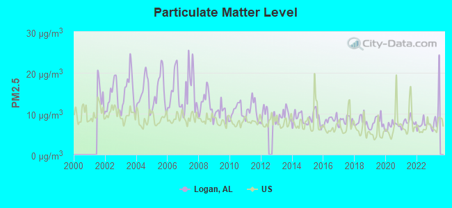
Particulate Matter (PM2.5) [µg/m3] level in 2022 was 7.31. This is about average. Closest monitor was 24.7 miles away from the city center.
| City: | 7.31 |
| U.S.: | 8.11 |
Tornado activity:
Logan-area historical tornado activity is slightly above Alabama state average. It is 177% greater than the overall U.S. average.
On 4/3/1974, a category F5 (max. wind speeds 261-318 mph) tornado 23.8 miles away from the Logan place center killed 28 people and injured 272 people.
On 4/24/1955, a category F4 (max. wind speeds 207-260 mph) tornado 14.3 miles away from the place center killed 5 people and injured 20 people and caused between $500,000 and $5,000,000 in damages.
Earthquake activity:
Logan-area historical earthquake activity is significantly above Alabama state average. It is 160% greater than the overall U.S. average.On 1/18/1999 at 07:00:53, a magnitude 4.8 (4.8 MB, 4.0 LG, Depth: 0.6 mi, Class: Light, Intensity: IV - V) earthquake occurred 54.9 miles away from the city center
On 4/29/2003 at 08:59:39, a magnitude 4.9 (4.4 MB, 4.6 MW, 4.9 LG) earthquake occurred 79.3 miles away from the city center
On 4/29/2003 at 08:59:39, a magnitude 4.6 (4.6 MW, Depth: 12.3 mi) earthquake occurred 79.3 miles away from Logan center
On 6/24/1975 at 11:11:36, a magnitude 4.5 (4.5 MB) earthquake occurred 59.1 miles away from Logan center
On 3/25/1976 at 00:41:20, a magnitude 5.0 (4.9 MB, 5.0 LG, Class: Moderate, Intensity: VI - VII) earthquake occurred 216.8 miles away from Logan center
On 4/18/2008 at 09:36:59, a magnitude 5.4 (5.1 MB, 4.8 MS, 5.4 MW, 5.2 MW) earthquake occurred 301.5 miles away from Logan center
Magnitude types: regional Lg-wave magnitude (LG), body-wave magnitude (MB), surface-wave magnitude (MS), moment magnitude (MW)
Natural disasters:
The number of natural disasters in Cullman County (28) is a lot greater than the US average (15).Major Disasters (Presidential) Declared: 19
Emergencies Declared: 5
Causes of natural disasters: Storms: 17, Floods: 13, Tornadoes: 12, Hurricanes: 5, Winds: 4, Freezes: 2, Winter Storms: 2, Drought: 1, Ice Storm: 1, Snowfall: 1, Other: 1 (Note: some incidents may be assigned to more than one category).
Hospitals and medical centers near Logan:
- CULLMAN COUNTY HOME CARE (Home Health Center, about 6 miles away; CULLMAN, AL)
- CULLMAN OUTPATIENT SERVICES LTD (Hospital, about 7 miles away; CULLMAN, AL)
- WOODLAND VILLAGE HEALTH CARE CENTER (Nursing Home, about 7 miles away; CULLMAN, AL)
- CULLMAN HEALTH CARE CENTER (Nursing Home, about 7 miles away; CULLMAN, AL)
- HOSPICE OF CULLMAN COUNTY (Hospital, about 7 miles away; CULLMAN, AL)
- DCI CULLMAN (Dialysis Facility, about 8 miles away; CULLMAN, AL)
- SOUTHERNCARE CULLMAN (Hospital, about 14 miles away; HANCEVILLE, AL)
Colleges/universities with over 2000 students nearest to Logan:
- George C Wallace State Community College-Hanceville (about 12 miles; Hanceville, AL; Full-time enrollment: 4,486)
- Bevill State Community College (about 29 miles; Jasper, AL; FT enrollment: 2,970)
- John C Calhoun State Community College (about 35 miles; Tanner, AL; FT enrollment: 7,911)
- Jefferson State Community College (about 38 miles; Birmingham, AL; FT enrollment: 6,041)
- University of Alabama in Huntsville (about 44 miles; Huntsville, AL; FT enrollment: 6,006)
- Athens State University (about 45 miles; Athens, AL; FT enrollment: 2,771)
- Snead State Community College (about 46 miles; Boaz, AL; FT enrollment: 2,023)
Public elementary/middle school in Logan:
- HARMONY SCH (Students: 307, Location: 4910 COUNTY ROAD 940, Grades: KG-8)
Points of interest:
Notable locations in Logan: Steele Orchard (A), Bethel Community Center (B), Bethsadia Volunteer Fire Department Station 1 (C), Trimble Volunteer Fire Department Station 1 (D), Logan Fire Department Station 1 (E), Bethsadia Volunteer Fire Department Station 2 (F), Logan Fire Department Station 2 (G). Display/hide their locations on the map
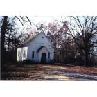
Churches in Logan include: Pleasant View Congregational Methodist Church (A), Salem Missionary Baptist Church (B), Walker United Methodist Church (C), Bethsadia Baptist Church (D), Logan Missionary Baptist Church (E), Shady Grove Methodist Church (F), Spring Hill Baptist Church (G), Prospect Church (H), Center Hill Methodist Church (I). Display/hide their locations on the map
Cemeteries: Spitznagl Cemetery (1), Pullen Cemetery (2), Emeus Cemetery (3), Bethsadia Cemetery (4), Logan Cemetery (5), Shady Grove Cemetery (6), Crosses Chapel Cemetery (7). Display/hide their locations on the map
Lakes and reservoirs: Browns Pond (A), Whites Pond (B), Lick Creek Pond (C). Display/hide their locations on the map
Streams, rivers, and creeks: Patterson Branch (A), Moore Branch (B), Clear Creek (C), Bavar Creek (D). Display/hide their locations on the map
| This place: | 2.6 people |
| Alabama: | 2.5 people |
| This place: | 76.0% |
| Whole state: | 67.8% |
| This place: | 3.6% |
| Whole state: | 4.7% |
Likely homosexual households (counted as self-reported same-sex unmarried-partner households)
- Lesbian couples: 0.3% of all households
- Gay men: 0.3% of all households
| This place: | 12.5% |
| Whole state: | 16.1% |
| This place: | 7.1% |
| Whole state: | 7.3% |
For population 15 years and over in Logan:
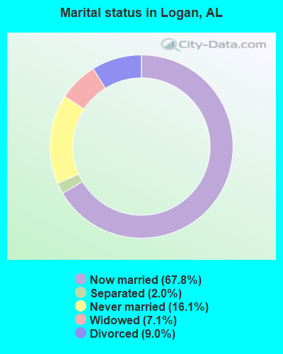
- Never married: 16.1%
- Now married: 67.8%
- Separated: 2.0%
- Widowed: 7.1%
- Divorced: 9.0%
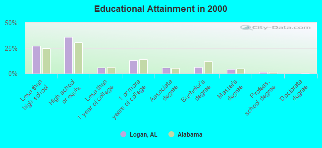
For population 25 years and over in Logan:
- High school or higher: 72.9%
- Bachelor's degree or higher: 12.1%
- Graduate or professional degree: 5.9%
- Unemployed: 3.3%
- Mean travel time to work (commute): 31.5 minutes
| Here: | 13.4 |
| Alabama average: | 13.2 |
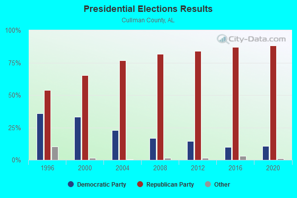
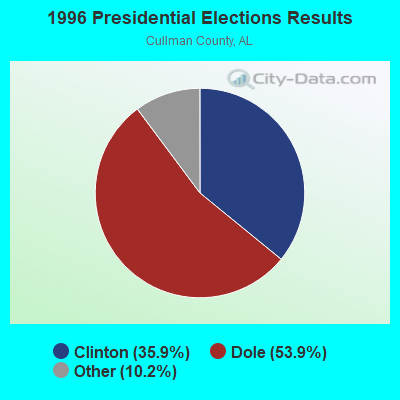
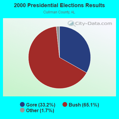
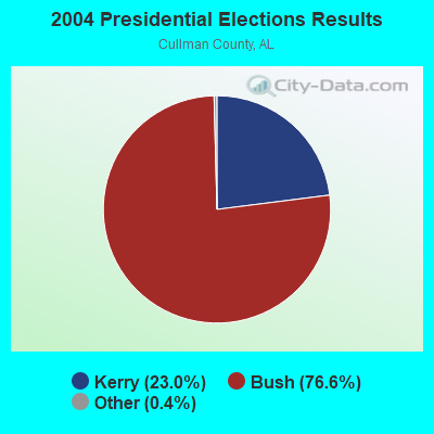
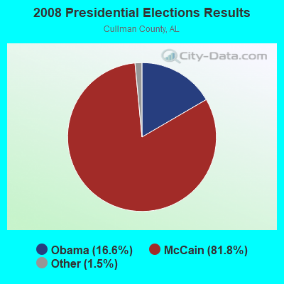
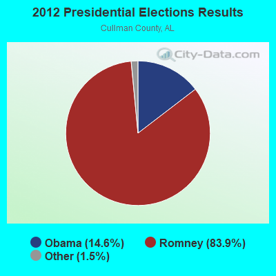
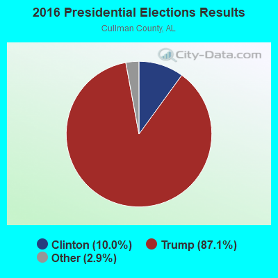
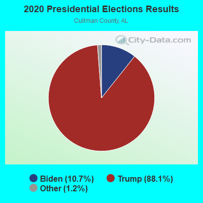
Graphs represent county-level data. Detailed 2008 Election Results
Religion statistics for Logan, AL (based on Cullman County data)
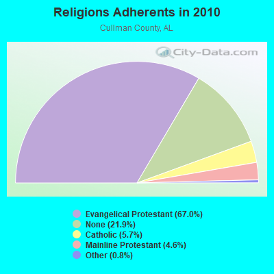
| Religion | Adherents | Congregations |
|---|---|---|
| Evangelical Protestant | 53,863 | 199 |
| Catholic | 4,614 | 2 |
| Mainline Protestant | 3,698 | 24 |
| Other | 624 | 2 |
| None | 17,607 | - |
Food Environment Statistics:
| This county: | 1.24 / 10,000 pop. |
| State: | 1.89 / 10,000 pop. |
| This county: | 0.12 / 10,000 pop. |
| Alabama: | 0.20 / 10,000 pop. |
| Cullman County: | 0.25 / 10,000 pop. |
| State: | 0.65 / 10,000 pop. |
| This county: | 6.84 / 10,000 pop. |
| Alabama: | 6.32 / 10,000 pop. |
| Here: | 6.59 / 10,000 pop. |
| State: | 5.75 / 10,000 pop. |
| Cullman County: | 10.7% |
| Alabama: | 11.8% |
| This county: | 29.4% |
| Alabama: | 31.7% |
| Cullman County: | 16.7% |
| Alabama: | 13.5% |
Strongest AM radio stations in Logan:
- WMCJ (1460 AM; 5 kW; CULLMAN, AL)
- WDJC (850 AM; 50 kW; BIRMINGHAM, AL; Owner: KIMTRON, INC.)
- WJOX (690 AM; 50 kW; BIRMINGHAM, AL; Owner: CITADEL BROADCASTING COMPANY)
- WAPI (1070 AM; 50 kW; BIRMINGHAM, AL; Owner: CITADEL BROADCASTING COMPANY)
- WFMH (1340 AM; 1 kW; CULLMAN, AL; Owner: VOICE OF CULLMAN, L.L.C.)
- WLOR (1550 AM; 50 kW; HUNTSVILLE, AL; Owner: BCA RADIO, LLC)
- WNSI (810 AM; 50 kW; JACKSONVILLE, AL; Owner: UNITED BROADCASTING NETWORK, INC.)
- WCOC (1010 AM; 5 kW; DORA, AL; Owner: AZTECA COMMUNICATIONS OF ALABAMA, INC.)
- WWAM (820 AM; daytime; 50 kW; JASPER, TN; Owner: SHELTON BROADCASTING SYSTEM)
- WVNN (770 AM; 10 kW; ATHENS, AL; Owner: ATHENS BROADCASTING COMPANY, INC.)
- WXRP (1170 AM; daytime; 1 kW; HANCEVILLE, AL; Owner: MAPLEWOOD PROPERTIES, LLC)
- WDJL (1000 AM; daytime; 10 kW; HUNTSVILLE, AL; Owner: JAMES K. SHARP DBA 5TH AVE BROADCASTING)
- WKNG (1060 AM; daytime; 50 kW; TALLAPOOSA, GA; Owner: WKNG, INC.)
Strongest FM radio stations in Logan:
- WYDE-FM (101.1 FM; CULLMAN, AL; Owner: KIMTRON, INC.)
- WRAX (107.7 FM; BIRMINGHAM, AL; Owner: CITADEL BROADCASTING COMPANY)
- WQAH-FM (105.7 FM; ADDISON, AL; Owner: ALVIN ABERCROMBIE)
- WRSA-FM (96.9 FM; DECATUR, AL; Owner: NCA, INC.)
- WTAK-FM (106.1 FM; HARTSELLE, AL; Owner: CAPSTAR TX LIMITED PARTNERSHIP)
- WKUL (92.1 FM; CULLMAN, AL; Owner: JONATHAN CHRISTIAN CORP.)
- WDXB (102.5 FM; JASPER, AL; Owner: CAPSTAR TX LIMITED PARTNERSHIP)
- WAHR (99.1 FM; HUNTSVILLE, AL; Owner: BCA RADIO, LLC)
- WFMH-FM (95.5 FM; HOLLY POND, AL; Owner: VOICE OF CULLMAN, L.L.C.)
- WEUP-FM (103.1 FM; MOULTON, AL; Owner: HUNDLEY BATES, SR. AND VIRGINIA CAPLES)
- W289AC (105.7 FM; HUNTSVILLE, AL; Owner: WILLIAM PAXTON ROGERS)
- WBHK (98.7 FM; WARRIOR, AL; Owner: CXR HOLDINGS, INC.)
- WBPT (106.9 FM; BIRMINGHAM, AL; Owner: CXR HOLDINGS, INC.)
- WZZK-FM (104.7 FM; BIRMINGHAM, AL; Owner: CXR HOLDINGS, INC.)
- WRJL-FM (99.9 FM; EVA, AL; Owner: ROJO, INC.)
- WODL (97.3 FM; HOMEWOOD, AL; Owner: CXR HOLDINGS, INC.)
- WBHM (90.3 FM; BIRMINGHAM, AL; Owner: BD OF TRUSTEES/U OF AL AT BIRMINGHAM)
- WXQW (94.1 FM; MERIDIANVILLE, AL; Owner: CAPSTAR TX LIMITED PARTNERSHIP)
- WYSF (94.5 FM; BIRMINGHAM, AL; Owner: CITADEL BROADCASTING COMPANY)
- W293AH (106.5 FM; NORMAL, AL; Owner: CAPSTAR TX LIMITED PARTNERSHIP)
TV broadcast stations around Logan:
- WCQT-LP (Channel 52; CULLMAN, AL; Owner: FIRST CULLMAN BROADCASTING, INC.)
- WDBB (Channel 17; BESSEMER, AL; Owner: WDBB-TV, INC.)
- WCFT-TV (Channel 33; TUSCALOOSA, AL; Owner: TV ALABAMA, INCORPORATED)
- WZDX (Channel 54; HUNTSVILLE, AL; Owner: HUNTSVILLE TELEVISION ACQUISITION CORP.)
- WPXH (Channel 44; GADSDEN, AL; Owner: PAXSON COMMUNICATIONS LICENSE COMPANY, LLC)
- W55BJ (Channel 55; JASPER, AL; Owner: COMBS BROADCASTING, INC.)
- W66CN (Channel 66; JASPER, AL; Owner: TRINITY BROADCASTING NETWORK)
FCC Registered Antenna Towers:
24 (See the full list of FCC Registered Antenna Towers in Logan)FCC Registered Amateur Radio Licenses:
2- Call Sign: KQ4OUD, Licensee ID: L02753599, Grant Date: 02/14/2024, Expiration Date: 02/14/2034, Cancellation Date: 03/09/2024, Certifier: Michael Vaught, Registrant: Michael Vaught, 280 County Road 349, Logan, AL 35098-1023
- Call Sign: K1MJV, Previous Call Sign: KQ4OUD, Licensee ID: L02753599, Grant Date: 03/09/2024, Expiration Date: 03/09/2034, Certifier: Michael Vaught, Registrant: Michael Vaught, 280 County Road 349, Logan, AL 35098-1023
- 49.6%Electricity
- 42.3%Bottled, tank, or LP gas
- 4.8%Wood
- 2.7%Utility gas
- 0.5%Fuel oil, kerosene, etc.
- 61.0%Bottled, tank, or LP gas
- 35.5%Electricity
- 3.5%Wood
Logan compared to Alabama state average:
- Unemployed percentage significantly below state average.
- Black race population percentage significantly below state average.
- Hispanic race population percentage below state average.
- Median age below state average.
- Foreign-born population percentage significantly below state average.
- Renting percentage below state average.
- Length of stay since moving in significantly above state average.
- Number of rooms per house significantly below state average.
- House age significantly below state average.
- Number of college students below state average.
- Percentage of population with a bachelor's degree or higher below state average.
Logan on our top lists:
- #35 on the list of "Top 101 larger cities with the lowest real estate taxes percentage (population 50,000+)"
- #86 on the list of "Top 101 counties with the highest number of deaths per 1000 residents 2007-2013 (pop. 50,000+)"
- #101 on the list of "Top 101 counties with highest percentage of residents voting for Romney (Republican) in the 2012 Presidential Election"