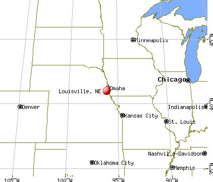
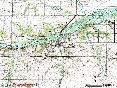
Louisville, Nebraska
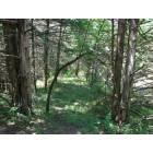
Louisville: Woods outside Louisville

Louisville: Platt River near Louisville

Louisville: Platte River near Louisville

Louisville: Pond near Louisville
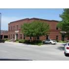
Louisville: Bank in Louisville
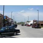
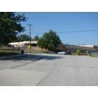
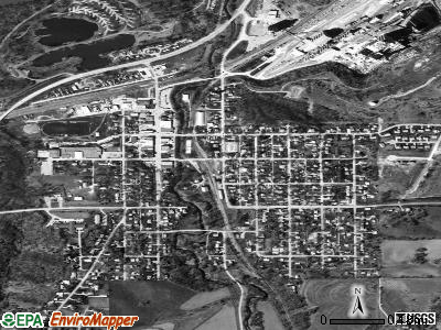
Louisville: Downtown Louisville
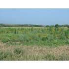
Louisville: wild flowers outside Louisville
Louisville: School in Louisville
- add
your


Submit your own pictures of this village and show them to the world
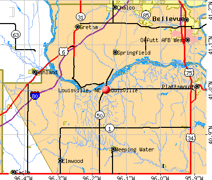
- OSM Map
- General Map
- Google Map
- MSN Map
Population change since 2000: +30.1%
 |
| Males: 637 | |
| Females: 724 |
| Median resident age: | 38.7 years |
| Nebraska median age: | 37.4 years |
Zip codes: 68037.
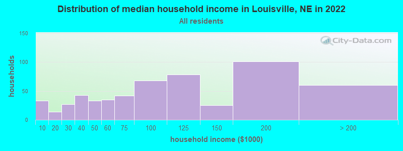
| Louisville: | $91,115 |
| NE: | $69,597 |
Estimated per capita income in 2022: $42,879 (it was $19,308 in 2000)
Louisville village income, earnings, and wages data
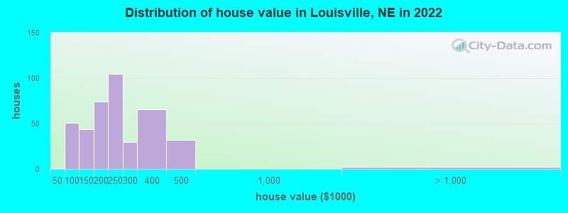
Estimated median house or condo value in 2022: $229,687 (it was $82,800 in 2000)
| Louisville: | $229,687 |
| NE: | $232,400 |
Mean prices in 2022: all housing units: $233,484; detached houses: $229,529; townhouses or other attached units: $258,449
Median gross rent in 2022: $935.
(6.8% for White Non-Hispanic residents, 9.5% for Hispanic or Latino residents, 20.0% for American Indian residents, 10.7% for other race residents, 4.2% for two or more races residents)
Detailed information about poverty and poor residents in Louisville, NE
Compare current foreclosures near Louisville, NE:
| Photo | Address | Area | Beds / Baths | Price | Details |
|---|---|---|---|---|---|

|
#1
Valley St
Omaha, NE 68130
|
1,623 sq. feet
|
2 baths 3 beds |
show details | |

|
#2
Gertrude St # 68147
Bellevue, NE 68147
|
1,429 sq. feet
|
2 baths 3 beds |
show details | |

|
#3
N 7th St
Plattsmouth, NE 68048
|
1,326 sq. feet
|
2 baths 4 beds |
show details | |

|
#4
E Q St
Weeping Water, NE 68463
|
- sq. feet
|
1 baths 3 beds |
show details | |

|
#5
S 49th St
Omaha, NE 68117
|
1,315 sq. feet
|
2 baths 3 beds |
show details | |

|
#6
S 78th Ave
Omaha, NE 68127
|
995 sq. feet
|
1 baths 3 beds |
show details | |

|
#7
S 36th Ave
Omaha, NE 68107
|
768 sq. feet
|
1 baths 3 beds |
show details | |

|
#8
Devon Dr
Papillion, NE 68046
|
1,012 sq. feet
|
2 baths 3 beds |
show details | |

|
#9
S 91st St
Omaha, NE 68127
|
1,416 sq. feet
|
1 baths 3 beds |
show details | |

|
#10
Giles Rd
Omaha, NE 68157
|
2,072 sq. feet
|
2 baths 3 beds |
show details |
| Photo | Address | Area | Beds / Baths | Price | Details |
|---|---|---|---|---|---|

|
#11
S 48th Ave
Omaha, NE 68157
|
2,465 sq. feet
|
2 baths 3 beds |
show details | |

|
#12
S 46th Ave
Omaha, NE 68157
|
1,418 sq. feet
|
1 baths 3 beds |
show details | |

|
#13
S 48th Ter
Omaha, NE 68157
|
1,496 sq. feet
|
2 baths 3 beds |
show details | |

|
#14
Weir St
Omaha, NE 68127
|
3,069 sq. feet
|
2 baths 3 beds |
show details | |

|
#15
Hayes Cir
Omaha, NE 68127
|
1,482 sq. feet
|
3 baths 3 beds |
show details | |

|
#16
Wildewood Dr
Omaha, NE 68127
|
1,500 sq. feet
|
2 baths 3 beds |
show details | |

|
#17
Briarwood Ln
Bellevue, NE 68147
|
1,620 sq. feet
|
2 baths 3 beds |
show details | |

|
#18
N St
Omaha, NE 68137
|
1,180 sq. feet
|
1 baths 3 beds |
show details | |

|
#19
S 194th Ave
Omaha, NE 68135
|
1,246 sq. feet
|
2 baths 3 beds |
show details | |

|
#20
Wildewood Dr
Omaha, NE 68127
|
1,160 sq. feet
|
1 baths 3 beds |
show details |
| Photo | Address | Area | Beds / Baths | Price | Details |
|---|---|---|---|---|---|

|
#21
N St
Omaha, NE 68137
|
1,225 sq. feet
|
1 baths 3 beds |
show details | |

|
#22
Oak Pl
Omaha, NE 68127
|
1,822 sq. feet
|
2 baths 3 beds |
show details | |

|
#23
Weir St
Omaha, NE 68127
|
1,248 sq. feet
|
2 baths 3 beds |
show details | |

|
#24
Copper Creek Rd
Omaha, NE 68157
|
1,196 sq. feet
|
2 baths 2 beds |
show details | |

|
#25
Lake Ridge Dr
Plattsmouth, NE 68048
|
1,639 sq. feet
|
2 baths 3 beds |
show details | |

|
#26
Hansen Cir
Bellevue, NE 68005
|
2,042 sq. feet
|
2 baths 3 beds |
show details | |

|
#27
S 130th St
Omaha, NE 68144
|
1,404 sq. feet
|
1 baths 3 beds |
show details | |

|
#28
Pasadena Ave
Omaha, NE 68130
|
3,296 sq. feet
|
3 baths 2 beds |
show details | |

|
#29
Sun Valley Dr
Omaha, NE 68157
|
1,344 sq. feet
|
1 baths 3 beds |
show details | |

|
#30
S 81st St
Omaha, NE 68127
|
2,084 sq. feet
|
1 baths 3 beds |
show details |
| Photo | Address | Area | Beds / Baths | Price | Details |
|---|---|---|---|---|---|

|
#31
Wallace Dr
Plattsmouth, NE 68048
|
3,776 sq. feet
|
2 baths 3 beds |
show details | |

|
#32
S 130th St
Omaha, NE 68144
|
924 sq. feet
|
1 baths 3 beds |
show details | |

|
#33
Howe St
Omaha, NE 68130
|
2,334 sq. feet
|
2 baths 3 beds |
show details | |

|
#34
Main St
Omaha, NE 68127
|
1,476 sq. feet
|
1 baths 3 beds |
show details | |

|
#35
S 46th Ave
Omaha, NE 68157
|
2,224 sq. feet
|
2 baths 4 beds |
show details | |

|
#36
Yorktown St
Bellevue, NE 68123
|
1,497 sq. feet
|
2 baths 3 beds |
show details | |

|
#37
S 25th Ave
Bellevue, NE 68123
|
1,724 sq. feet
|
2 baths 2 beds |
show details | |

|
#38
Greene Ave
Omaha, NE 68157
|
2,420 sq. feet
|
1 baths 3 beds |
show details | |

|
#39
Dunbar Dr
Plattsmouth, NE 68048
|
1,296 sq. feet
|
2 baths 3 beds |
show details | |

|
#40
Main St
Omaha, NE 68127
|
1,028 sq. feet
|
1 baths 1 beds |
show details |
| Photo | Address | Area | Beds / Baths | Price | Details |
|---|---|---|---|---|---|

|
#41
Bernadette Ave
Omaha, NE 68157
|
1,558 sq. feet
|
2 baths 3 beds |
show details | |

|
#42
S 104th Ave
Omaha, NE 68127
|
1,796 sq. feet
|
1 baths 4 beds |
show details | |

|
#43
7th Ave
Plattsmouth, NE 68048
|
1,144 sq. feet
|
2 baths 3 beds |
show details | |

|
#44
S 157th St
Omaha, NE 68135
|
1,530 sq. feet
|
2 baths 3 beds |
show details | |

|
#45
S 67th St
Papillion, NE 68133
|
1,910 sq. feet
|
2 baths 4 beds |
show details | |

|
#46
S 76th Ave
La Vista, NE 68128
|
1,517 sq. feet
|
1 baths 3 beds |
show details | |

|
#47
S 106th Cir
Omaha, NE 68127
|
3,397 sq. feet
|
2 baths 4 beds |
show details | |

|
#48
S 155th St
Omaha, NE 68137
|
1,176 sq. feet
|
2 baths 3 beds |
show details | |

|
#49
W St
Omaha, NE 68135
|
1,337 sq. feet
|
2 baths 3 beds |
show details | |

|
Check over 1 million property listings on Foreclosure.com!
|
browse all offers | |||


- 1,28685.4%White alone
- 946.2%Two or more races
- 442.9%Hispanic
- 291.9%American Indian alone
- 241.6%Asian alone
- 130.9%Native Hawaiian and Other
Pacific Islander alone - 120.8%Other race alone
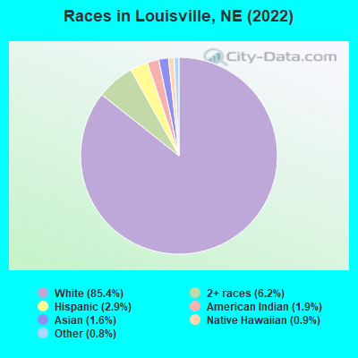
Races in Louisville detailed stats: ancestries, foreign born residents, place of birth
According to our research of Nebraska and other state lists, there were 8 registered sex offenders living in Louisville, Nebraska as of April 25, 2024.
The ratio of all residents to sex offenders in Louisville is 131 to 1.
 Recent articles from our blog. Our writers, many of them Ph.D. graduates or candidates, create easy-to-read articles on a wide variety of topics.


 | Is Omaha like Minneapolis? The vibe and the people. (27 replies) |
| The major differences between people in Texas and Nebraska (109 replies) |
| Is Omaha becoming more popular......or just a flyover city! (36 replies) |
| Omaha for a fresh start? (14 replies) |
| Louisville or Blair (22 replies) |
| Considering Move To Nebraska (14 replies) |
Latest news from Louisville, NE collected exclusively by city-data.com from local newspapers, TV, and radio stations
Ancestries: German (38.1%), English (8.2%), American (7.4%), Irish (6.6%), Czechoslovakian (4.0%), Czech (2.0%).
Current Local Time: CST time zone
Incorporated on 08/7/1882
Elevation: 1044 feet
Land area: 0.51 square miles.
Population density: 2,651 people per square mile (average).
20 residents are foreign born
| This village: | 1.3% |
| Nebraska: | 7.5% |
Median real estate property taxes paid for housing units with mortgages in 2022: $3,219 (1.4%)
Median real estate property taxes paid for housing units with no mortgage in 2022: $3,265 (1.4%)
Nearest city with pop. 50,000+: Omaha, NE  (19.6 miles , pop. 390,007).
Nearest city with pop. 1,000,000+: Chicago, IL (443.5 miles , pop. 2,896,016).
Nearest cities:
), ), ), ), Latitude: 41.00 N, Longitude: 96.16 W
Area code: 402
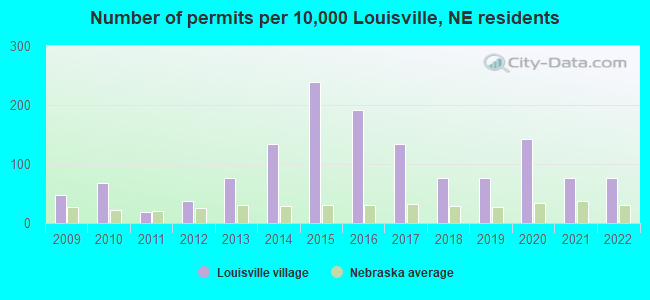
Single-family new house construction building permits:
- 2022: 8 buildings, average cost: $108,700
- 2021: 8 buildings, average cost: $93,200
- 2020: 15 buildings, average cost: $86,600
- 2019: 8 buildings, average cost: $99,000
- 2018: 8 buildings, average cost: $95,800
- 2017: 14 buildings, average cost: $95,900
- 2016: 20 buildings, average cost: $95,800
- 2015: 25 buildings, average cost: $99,100
- 2014: 14 buildings, average cost: $120,400
- 2013: 8 buildings, average cost: $95,800
- 2012: 4 buildings, average cost: $131,100
- 2011: 2 buildings, average cost: $100,200
- 2010: 7 buildings, average cost: $127,500
- 2009: 5 buildings, average cost: $132,900
| Here: | 2.2% |
| Nebraska: | 2.2% |
- Construction (13.0%)
- Health care (11.4%)
- Educational services (6.7%)
- Finance & insurance (6.4%)
- Truck transportation (5.7%)
- Nonmetallic mineral products (5.7%)
- Accommodation & food services (4.7%)
- Construction (21.6%)
- Nonmetallic mineral products (9.4%)
- Educational services (5.5%)
- Finance & insurance (5.2%)
- Truck transportation (4.8%)
- Utilities (4.5%)
- Administrative & support & waste management services (3.2%)
- Health care (23.0%)
- Educational services (8.2%)
- Finance & insurance (7.8%)
- Accommodation & food services (7.1%)
- Truck transportation (6.7%)
- Professional, scientific, technical services (3.7%)
- Administrative & support & waste management services (3.3%)
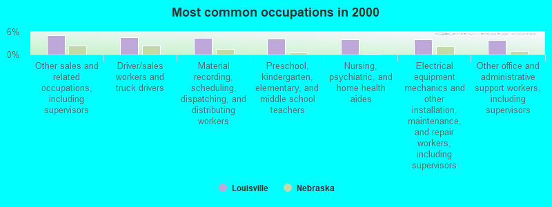
- Other sales and related occupations, including supervisors (5.2%)
- Driver/sales workers and truck drivers (4.5%)
- Material recording, scheduling, dispatching, and distributing workers (4.3%)
- Preschool, kindergarten, elementary, and middle school teachers (4.1%)
- Nursing, psychiatric, and home health aides (4.0%)
- Electrical equipment mechanics and other installation, maintenance, and repair workers, including supervisors (4.0%)
- Other office and administrative support workers, including supervisors (3.8%)
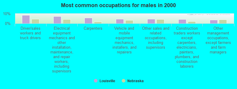
- Driver/sales workers and truck drivers (8.4%)
- Electrical equipment mechanics and other installation, maintenance, and repair workers, including supervisors (7.4%)
- Carpenters (5.8%)
- Vehicle and mobile equipment mechanics, installers, and repairers (4.5%)
- Other sales and related occupations, including supervisors (4.5%)
- Construction traders workers except carpenters, electricians, painters, plumbers, and construction laborers (4.2%)
- Other management occupations, except farmers and farm managers (3.5%)

- Nursing, psychiatric, and home health aides (8.6%)
- Registered nurses (6.7%)
- Secretaries and administrative assistants (5.9%)
- Other sales and related occupations, including supervisors (5.9%)
- Preschool, kindergarten, elementary, and middle school teachers (5.2%)
- Other office and administrative support workers, including supervisors (5.2%)
- Material recording, scheduling, dispatching, and distributing workers (5.2%)
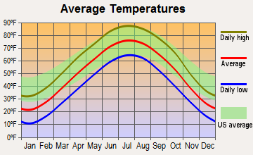
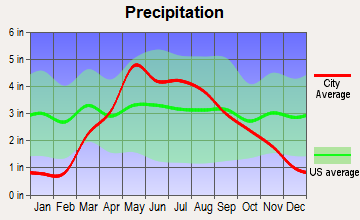
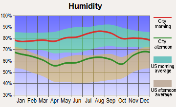
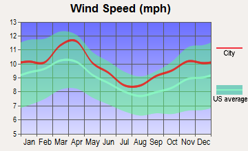
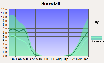
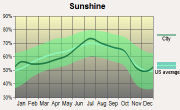
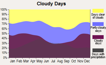
Average climate in Louisville, Nebraska
Based on data reported by over 4,000 weather stations
|
|

(lower is better)
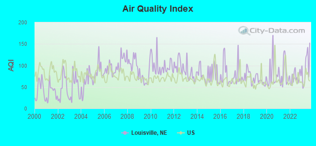
Air Quality Index (AQI) level in 2023 was 97.4. This is worse than average.
| City: | 97.4 |
| U.S.: | 72.6 |
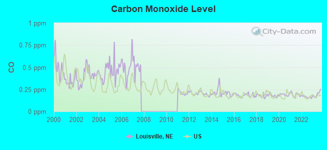
Carbon Monoxide (CO) [ppm] level in 2023 was 0.195. This is better than average. Closest monitor was 19.7 miles away from the city center.
| City: | 0.195 |
| U.S.: | 0.251 |
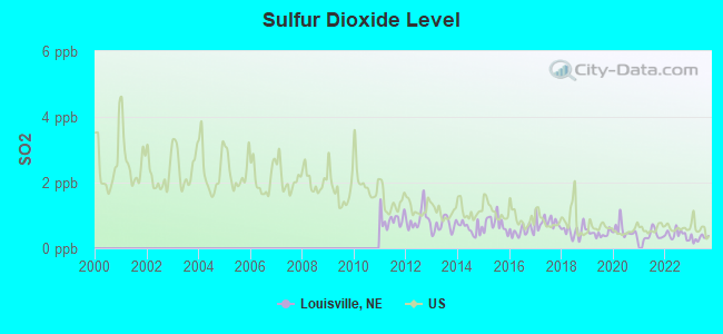
Sulfur Dioxide (SO2) [ppb] level in 2023 was 0.314. This is significantly better than average. Closest monitor was 12.6 miles away from the city center.
| City: | 0.314 |
| U.S.: | 1.515 |
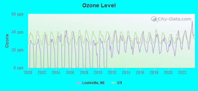
Ozone [ppb] level in 2023 was 37.1. This is about average. Closest monitor was 18.2 miles away from the city center.
| City: | 37.1 |
| U.S.: | 33.3 |
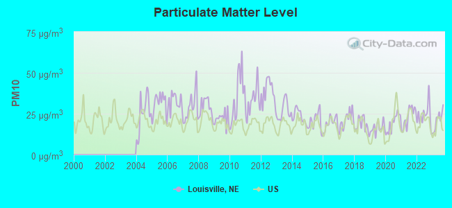
Particulate Matter (PM10) [µg/m3] level in 2023 was 21.0. This is about average. Closest monitor was 0.2 miles away from the city center.
| City: | 21.0 |
| U.S.: | 19.2 |
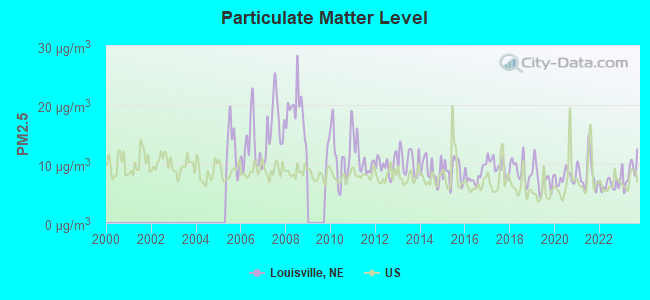
Particulate Matter (PM2.5) [µg/m3] level in 2023 was 8.81. This is about average. Closest monitor was 9.3 miles away from the city center.
| City: | 8.81 |
| U.S.: | 8.11 |
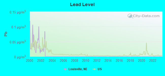
Lead (Pb) [µg/m3] level in 2002 was 0.0298. This is significantly worse than average. Closest monitor was 0.2 miles away from the city center.
| City: | 0.0298 |
| U.S.: | 0.0093 |
Tornado activity:
Louisville-area historical tornado activity is slightly above Nebraska state average. It is 96% greater than the overall U.S. average.
On 8/13/1952, a category F4 (max. wind speeds 207-260 mph) tornado 5.7 miles away from the Louisville village center injured 20 people and caused between $50,000 and $500,000 in damages.
On 5/6/1975, a category F4 tornado 12.7 miles away from the village center killed 3 people and injured 133 people and caused between $50,000 and $500,000 in damages.
Earthquake activity:
Louisville-area historical earthquake activity is significantly above Nebraska state average. It is 340% greater than the overall U.S. average.On 9/3/2016 at 12:02:44, a magnitude 5.8 (5.8 MW, Depth: 3.5 mi, Class: Moderate, Intensity: VI - VII) earthquake occurred 319.1 miles away from the city center
On 11/6/2011 at 03:53:10, a magnitude 5.7 (5.7 MW, Depth: 3.2 mi) earthquake occurred 379.6 miles away from Louisville center
On 6/22/2019 at 08:50:24, a magnitude 4.6 (4.6 MW, Depth: 1.9 mi, Class: Light, Intensity: IV - V) earthquake occurred 212.3 miles away from the city center
On 11/12/2014 at 21:40:00, a magnitude 4.9 (4.9 MW, Depth: 2.5 mi) earthquake occurred 269.5 miles away from the city center
On 12/17/2009 at 02:53:42, a magnitude 3.6 (3.6 MB, Depth: 3.1 mi, Class: Light, Intensity: II - III) earthquake occurred 43.9 miles away from Louisville center
On 11/3/2002 at 20:41:56, a magnitude 4.3 (4.3 MB, Depth: 3.1 mi) earthquake occurred 186.6 miles away from the city center
Magnitude types: body-wave magnitude (MB), moment magnitude (MW)
Natural disasters:
The number of natural disasters in Cass County (21) is greater than the US average (15).Major Disasters (Presidential) Declared: 16
Emergencies Declared: 2
Causes of natural disasters: Floods: 16, Storms: 14, Tornadoes: 9, Winds: 5, Snows: 2, Winter Storms: 2, Hurricane: 1, Snowstorm: 1, Other: 1 (Note: some incidents may be assigned to more than one category).
Hospitals and medical centers in Louisville:
Other hospitals and medical centers near Louisville:
- NEBRASKA HOME HEALTH CARE, LLC (Home Health Center, about 11 miles away; GRETNA, NE)
- GRETNA CARE CENTER (Nursing Home, about 11 miles away; GRETNA, NE)
- ALEGENT HEALTH MIDLANDS HOSPITAL Acute Care Hospitals (about 12 miles away; PAPILLION, NE)
- SELECT SPECIALTY HOSPITAL - OMAHA (SOUTH CAMPUS) (Hospital, about 12 miles away; PAPILLION, NE)
- ASHLAND CARE CENTER (Nursing Home, about 12 miles away; ASHLAND, NE)
- PAPILLION DIALYSIS (Dialysis Facility, about 12 miles away; PAPILLION, NE)
- HUNTINGTON PARK CARE CENTER (Nursing Home, about 12 miles away; PAPILLION, NE)
Colleges/universities with over 2000 students nearest to Louisville:
- Bellevue University (about 17 miles; Bellevue, NE; Full-time enrollment: 7,139)
- University of Nebraska at Omaha (about 20 miles; Omaha, NE; FT enrollment: 12,073)
- University of Nebraska Medical Center (about 21 miles; Omaha, NE; FT enrollment: 2,815)
- Creighton University (about 22 miles; Omaha, NE; FT enrollment: 5,370)
- Metropolitan Community College Area (about 24 miles; Omaha, NE; FT enrollment: 12,236)
- Iowa Western Community College (about 27 miles; Council Bluffs, IA; FT enrollment: 5,344)
- Southeast Community College Area (about 28 miles; Lincoln, NE; FT enrollment: 8,838)
Public high school in Louisville:
- LOUISVILLE HIGH SCHOOL (Students: 170, Location: 202 W 3RD, Grades: 9-12)
Public elementary/middle schools in Louisville:
- LOUISVILLE ELEMENTARY SCHOOL (Students: 235, Location: 202 W 3RD, Grades: PK-5)
- LOUISVILLE MIDDLE SCHOOL (Students: 117, Location: 202 W 3RD ST, Grades: 6-8)
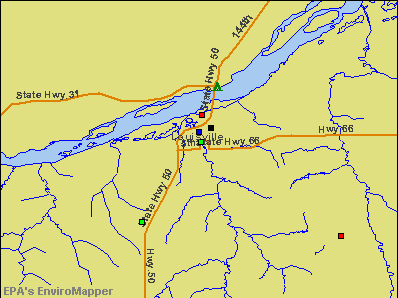
Points of interest:
Notable locations in Louisville: Louisville (A), Louisville Public Library (B), Louisville Volunteer Fire and Rescue Department (C). Display/hide their locations on the map
Churches in Louisville include: First Christian Church (A), United Methodist Church (B). Display/hide their locations on the map
Creek: Mill Creek (A). Display/hide its location on the map
Birthplace of: Joseph Jackson - College basketball player (Denver Pioneers).
Drinking water stations with addresses in Louisville and their reported violations in the past:
YMCA CAMP KITAKI (Population served: 40, Groundwater):Past health violations:Past monitoring violations:
- MCL, Monthly (TCR) - In SEP-2011, Contaminant: Coliform. Follow-up actions: St Public Notif requested (SEP-22-2011), St Violation/Reminder Notice (SEP-22-2011), St Public Notif received (OCT-14-2011)
- One regular monitoring violation
Drinking water stations with addresses in Louisville that have no violations reported:
- LOUISVILLE, CITY OF (Population served: 1,046, Primary Water Source Type: Groundwater)
- RAVEN'S NEST (Population served: 58, Primary Water Source Type: Groundwater)
| This village: | 2.3 people |
| Nebraska: | 2.5 people |
| This village: | 62.5% |
| Whole state: | 64.8% |
| This village: | 5.0% |
| Whole state: | 6.0% |
Likely homosexual households (counted as self-reported same-sex unmarried-partner households)
- Lesbian couples: 0.0% of all households
- Gay men: 0.4% of all households
Banks with branches in Louisville (2011 data):
- Farmers Bank of Cook: Farmers Bank Of Cook, Louisville Branch at 104 1/2 Main Street, branch established on 2005/06/27. Info updated 2006/11/03: Bank assets: $83.2 mil, Deposits: $70.3 mil, headquarters in Cook, NE, positive income, Agricultural Specialization, 8 total offices, Holding Company: Bancook Corporation
- Home State Bank: at 218 Main Street, branch established on 1915/01/01. Info updated 2010/05/04: Bank assets: $79.8 mil, Deposits: $54.7 mil, local headquarters, positive income, Commercial Lending Specialization, 1 total offices, Holding Company: Louisville Company
For population 15 years and over in Louisville:
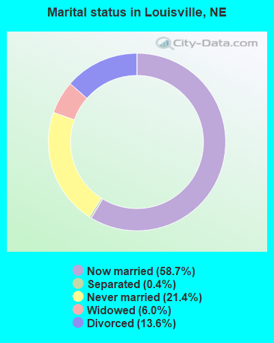
- Never married: 21.4%
- Now married: 58.7%
- Separated: 0.4%
- Widowed: 6.0%
- Divorced: 13.6%
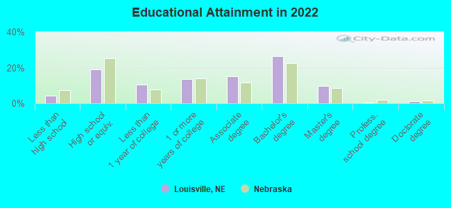
For population 25 years and over in Louisville:
- High school or higher: 94.9%
- Bachelor's degree or higher: 36.2%
- Graduate or professional degree: 10.5%
- Unemployed: 2.7%
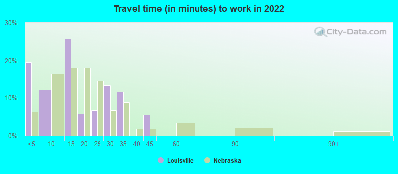
- Mean travel time to work (commute): 26.1 minutes
| Here: | 8.1 |
| Nebraska average: | 11.2 |
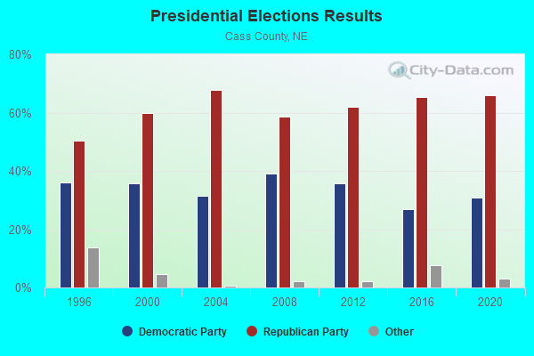
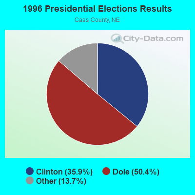
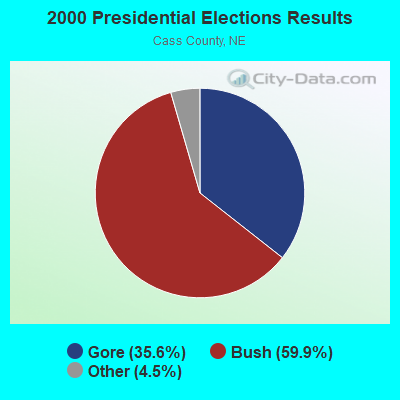
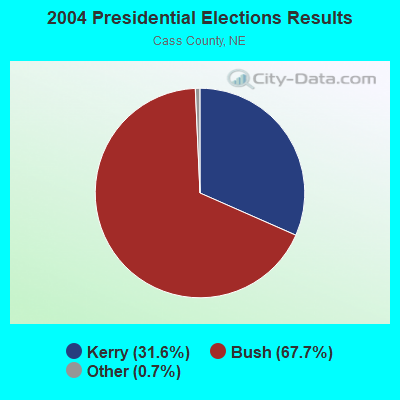

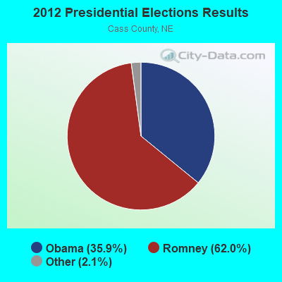
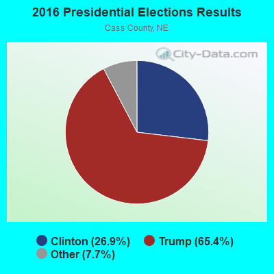
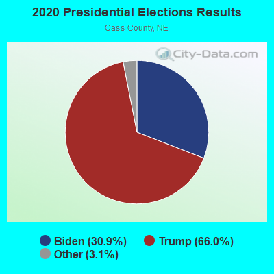
Graphs represent county-level data. Detailed 2008 Election Results
Religion statistics for Louisville, NE (based on Cass County data)
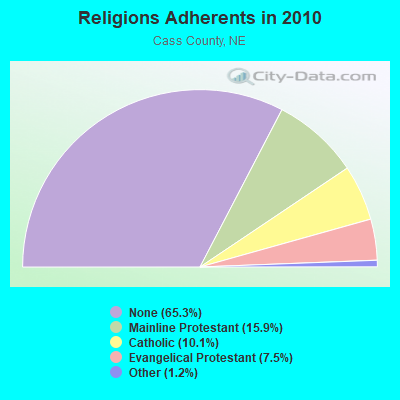
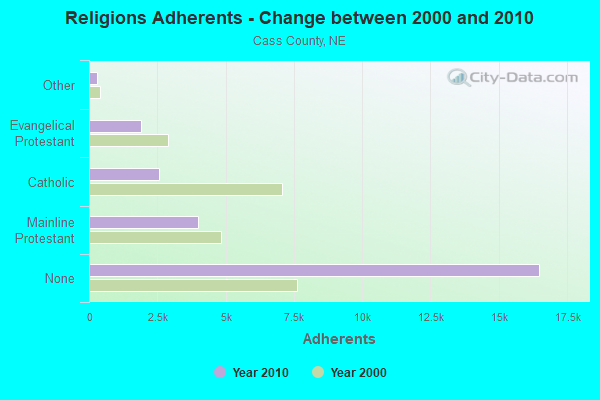
| Religion | Adherents | Congregations |
|---|---|---|
| Mainline Protestant | 4,007 | 25 |
| Catholic | 2,557 | 4 |
| Evangelical Protestant | 1,886 | 13 |
| Other | 302 | 2 |
| None | 16,489 | - |
Food Environment Statistics:
| This county: | 1.96 / 10,000 pop. |
| State: | 2.60 / 10,000 pop. |
| Cass County: | 0.78 / 10,000 pop. |
| Nebraska: | 0.44 / 10,000 pop. |
| Here: | 6.28 / 10,000 pop. |
| Nebraska: | 4.83 / 10,000 pop. |
| This county: | 5.49 / 10,000 pop. |
| Nebraska: | 7.76 / 10,000 pop. |
| Cass County: | 7.8% |
| State: | 7.9% |
| Cass County: | 26.5% |
| Nebraska: | 28.0% |
| Cass County: | 11.6% |
| Nebraska: | 12.9% |
Health and Nutrition:
| Here: | 47.9% |
| Nebraska: | 48.9% |
| Louisville: | 48.4% |
| Nebraska: | 45.5% |
| Louisville: | 28.4 |
| Nebraska: | 28.6 |
| Louisville: | 20.0% |
| Nebraska: | 21.4% |
| Louisville: | 14.3% |
| Nebraska: | 10.5% |
| This city: | 6.7 |
| Nebraska: | 6.8 |
| Louisville: | 35.9% |
| State: | 33.5% |
| Louisville: | 55.4% |
| State: | 55.6% |
| This city: | 83.5% |
| Nebraska: | 78.2% |
More about Health and Nutrition of Louisville, NE Residents
| Local government employment and payroll (March 2022) | |||||
| Function | Full-time employees | Monthly full-time payroll | Average yearly full-time wage | Part-time employees | Monthly part-time payroll |
|---|---|---|---|---|---|
| Streets and Highways | 4 | $17,027 | $51,081 | 0 | $0 |
| Financial Administration | 2 | $9,043 | $54,258 | 0 | $0 |
| Local Libraries | 0 | $0 | 1 | $1,332 | |
| Totals for Government | 6 | $26,069 | $52,138 | 1 | $1,332 |
Louisville government finances - Expenditure in 2021 (per resident):
- Construction - Public Welfare Institutions: $163,000 ($119.76)
- Current Operations - Public Welfare Institutions: $5,147,000 ($3781.78)
Water Utilities: $304,000 ($223.37)
Regular Highways: $283,000 ($207.94)
Housing and Community Development: $232,000 ($170.46)
Sewerage: $231,000 ($169.73)
Central Staff Services: $169,000 ($124.17)
Financial Administration: $130,000 ($95.52)
Protective Inspection and Regulation - Other: $90,000 ($66.13)
Solid Waste Management: $88,000 ($64.66)
Parks and Recreation: $62,000 ($45.55)
Police Protection: $61,000 ($44.82)
Local Fire Protection: $39,000 ($28.66)
General Public Buildings: $26,000 ($19.10)
Libraries: $21,000 ($15.43)
Public Welfare - Other: $7,000 ($5.14)
Health - Other: $5,000 ($3.67)
- General - Interest on Debt: $168,000 ($123.44)
- Other Capital Outlay - Regular Highways: $325,000 ($238.80)
Public Welfare Institutions: $300,000 ($220.43)
Protective Inspection and Regulation - Other: $250,000 ($183.69)
Sewerage: $85,000 ($62.45)
Parks and Recreation: $54,000 ($39.68)
Water Utilities: $25,000 ($18.37)
Libraries: $18,000 ($13.23)
Public Welfare - Other: $6,000 ($4.41)
Health - Other: $4,000 ($2.94)
- Total Salaries and Wages: $3,241,000 ($2381.34)
Louisville government finances - Revenue in 2021 (per resident):
- Charges - Other: $3,917,000 ($2878.03)
Sewerage: $386,000 ($283.61)
Solid Waste Management: $66,000 ($48.49)
Parks and Recreation: $14,000 ($10.29)
- Miscellaneous - General Revenue - Other: $939,000 ($689.93)
Interest Earnings: $70,000 ($51.43)
- Revenue - Water Utilities: $457,000 ($335.78)
- State Intergovernmental - Highways: $125,000 ($91.84)
General Local Government Support: $28,000 ($20.57)
- Tax - Other License: $1,445,000 ($1061.72)
Property: $416,000 ($305.66)
General Sales and Gross Receipts: $199,000 ($146.22)
Louisville government finances - Debt in 2021 (per resident):
- Long Term Debt - Beginning Outstanding - Unspecified Public Purpose: $4,661,000 ($3424.69)
Outstanding Unspecified Public Purpose: $4,189,000 ($3077.88)
Retired Unspecified Public Purpose: $582,000 ($427.63)
Issue, Unspecified Public Purpose: $110,000 ($80.82)
Louisville government finances - Cash and Securities in 2021 (per resident):
- Other Funds - Cash and Securities: $3,520,000 ($2586.33)
Businesses in Louisville, NE
- Chevrolet: 1
- Subway: 1
Strongest AM radio stations in Louisville:
- KFAB (1110 AM; 50 kW; OMAHA, NE; Owner: CAPSTAR TX LIMITED PARTNERSHIP)
- KOIL (1020 AM; 50 kW; PLATTSMOUTH, NE; Owner: WAITT RADIO, INC.)
- KKAR (1290 AM; 50 kW; OMAHA, NE; Owner: WAITT RADIO, INC.)
- KYDZ (1180 AM; 25 kW; BELLEVUE, NE; Owner: WAITT RADIO, INC.)
- KOZN (1620 AM; 10 kW; BELLEVUE, NE; Owner: WAITT RADIO, INC.)
- KLNG (1560 AM; daytime; 10 kW; COUNCIL BLUFFS, IA)
- KOMJ (590 AM; 5 kW; OMAHA, NE; Owner: JOURNAL BROADCAST CORPORATION)
- WHB (810 AM; 50 kW; KANSAS CITY, MO; Owner: UNION BROADCASTING, INC.)
- KCRO (660 AM; 1 kW; OMAHA, NE; Owner: ETERNAL BROADCASTING, LLC)
- KMA (960 AM; 5 kW; SHENANDOAH, IA; Owner: KMA BROADCASTING L.P.)
- WHO (1040 AM; 50 kW; DES MOINES, IA; Owner: CITICASTERS LICENSES, L.P.)
- KHLP (1420 AM; 1 kW; OMAHA, NE; Owner: JOURNAL BROADCAST CORPORATION)
- KOSR (1490 AM; 1 kW; OMAHA, NE; Owner: JOURNAL BROADCAST CORPORATION)
Strongest FM radio stations in Louisville:
- KLTQ (101.9 FM; LINCOLN, NE; Owner: WAITT RADIO, INC.)
- KGBI-FM (100.7 FM; OMAHA, NE; Owner: GRACE UNIVERSITY)
- KEFM (96.1 FM; OMAHA, NE; Owner: WEBSTER COMMUNICATIONS CO.)
- KBBX-FM (97.7 FM; NEBRASKA CITY, NE; Owner: JOURNAL BROADCAST CORPORATION)
- KFRX (102.7 FM; LINCOLN, NE; Owner: THREE EAGLES OF LINCOLN, INC.)
- KMLV (88.1 FM; RALSTON, NE; Owner: EDUCATIONAL MEDIA FOUNDATION)
- KGOR (99.9 FM; OMAHA, NE; Owner: CAPSTAR TX LIMITED PARTNERSHIP)
- KQCH (94.1 FM; OMAHA, NE; Owner: JOURNAL BROADCAST CORPORATION)
- KEZO-FM (92.3 FM; OMAHA, NE; Owner: JOURNAL BROADCAST CORPORATION)
- KQKQ-FM (98.5 FM; COUNCIL BLUFFS, IA; Owner: WAITT RADIO, INC.)
- KSRZ (104.5 FM; OMAHA, NE; Owner: JOURNAL BROADCAST CORPORATION)
- KIWR (89.7 FM; COUNCIL BLUFFS, IA; Owner: IOWA WESTERN COMMUNITY COLLEGE)
- KVNO (90.7 FM; OMAHA, NE; Owner: THE BOARD OF REGENTS OF UNIV. OF NEBRASKA)
- KCTY-FM (106.9 FM; PLATTSMOUTH, NE; Owner: PLATTE BROADCASTING COMPANY, INC.)
- KIOS-FM (91.5 FM; OMAHA, NE; Owner: DOUGLAS COUNTY SCHOOL DISTRICT 001)
- KKCD (105.9 FM; OMAHA, NE; Owner: JOURNAL BROADCAST CORPORATION)
- KIBZ (106.3 FM; LINCOLN, NE; Owner: CAPSTAR TX LIMITED PARTNERSHIP)
- KXKT (103.7 FM; GLENWOOD, IA; Owner: CAPSTAR TX LIMITED PARTNERSHIP)
- K299AK (107.7 FM; OMAHA, NE; Owner: BAER COMMUNICATIONS, INC.)
- KVSS (88.9 FM; OMAHA, NE; Owner: VSS CATHOLIC COMMUNICATIONS, INC.)
TV broadcast stations around Louisville:
- KPTM (Channel 42; OMAHA, NE; Owner: PAPPAS TELECASTING OF THE MIDLANDS)
- KXVO (Channel 15; OMAHA, NE; Owner: MITTS TELECASTING COMPANY)
- KUON-TV (Channel 12; LINCOLN, NE; Owner: THE UNIVERSITY OF NEBRASKA)
- KYNE-TV (Channel 26; OMAHA, NE; Owner: NEBRASKA EDUCATIONAL TELECOMMUNICATIONS COMM.)
- KMTV (Channel 3; OMAHA, NE; Owner: EMMIS TELEVISION LICENSE CORPORATION)
- KETV (Channel 7; OMAHA, NE; Owner: KETV HEARST-ARGYLE TELEVISION, INC.)
- WOWT-TV (Channel 6; OMAHA, NE; Owner: GRAY MIDAMERICA TV LICENSEE CORP.)
- KVSS-LP (Channel 67; OMAHA, NE; Owner: VSS CATHOLIC COMMUNICATIONS)
- KLKN (Channel 8; LINCOLN, NE; Owner: CITADEL COMMUNICATIONS, L.L.C.)
- K21ES (Channel 21; COLUMBUS, ETC, NE; Owner: DAVID C. BRODAHL)
- K54EU (Channel 54; COLUMBUS-FREMONT, NE; Owner: GLENDA R. HARDERS)
- K61GA (Channel 61; OMAHA, NE; Owner: THREE ANGELS BROADCASTING NETWORK)
- KHIN (Channel 36; RED OAK, IA; Owner: IOWA PUBLIC BROADCASTING BOARD)
- KKAZ-CA (Channel 24; OMAHA, NE; Owner: PAPPAS TELECASTING OF THE MIDLANDS)
- K18CD (Channel 18; LINCOLN, NE; Owner: COLINS BROADCASTING COMPANY)
- K53EY (Channel 53; OMAHA, NE; Owner: TV-45, INC.)
Louisville fatal accident list:
Jan 7, 1998 07:37 AM, Sr-50, Vehicles: 2, Persons: 3, Fatalities: 1
Oct 24, 1993 03:58 PM, 50, Vehicles: 2, Persons: 3, Fatalities: 1
Jul 17, 1982 11:30 PM, N66, Vehicles: 1, Persons: 2, Fatalities: 1, Drunk persons involved: 1
- National Bridge Inventory (NBI) Statistics
- 19Number of bridges
- 292ft / 89.3mTotal length
- 39,565Total average daily traffic
- 5,833Total average daily truck traffic
- 61,508Total future (year 2033) average daily traffic
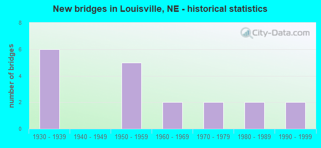
- New bridges - historical statistics
- 61930-1939
- 51950-1959
- 21960-1969
- 21970-1979
- 21980-1989
- 21990-1999
FCC Registered Antenna Towers:
33 (See the full list of FCC Registered Antenna Towers in Louisville)FCC Registered Broadcast Land Mobile Towers:
8 (See the full list of FCC Registered Broadcast Land Mobile Towers in Louisville, NE)FCC Registered Microwave Towers:
15 (See the full list of FCC Registered Microwave Towers in this town)FCC Registered Amateur Radio Licenses:
4- Call Sign: AA0NF, Previous Call Sign: N0UCP, Licensee ID: L00692604, Grant Date: 10/31/2023, Expiration Date: 10/31/2033, Certifier: Steven J Sebranek, Registrant: Steven J Sebranek, 310 W 3rd St, Louisville, NE 68037
- Call Sign: KB0OGO, Licensee ID: L00228287, Grant Date: 05/24/2014, Expiration Date: 07/16/2024, Certifier: Roger J Behrns, Registrant: Roger J Behrns, 513 Vine St, Louisville, NE 68037
- Call Sign: KC0HTM, Licensee ID: L00229392, Grant Date: 02/26/2020, Expiration Date: 04/19/2030, Certifier: Thomas A Korn, Registrant: Thomas A Korn, 403 East 2nd Str, Louisville, NE 68037
- Call Sign: KD0UYE, Licensee ID: L01777861, Grant Date: 05/23/2023, Expiration Date: 05/23/2033, Certifier: Benjamin Barenz, Registrant: Benjamin Barenz, 115 Main St, Louisville, NE 68037
FAA Registered Aircraft:
2- Aircraft: GRUMMAN AMERICAN AVN. CORP. AA-1B (Category: Land, Seats: 2, Weight: Up to 12,499 Pounds, Speed: 100 mph), Engine: LYCOMING 0-235 SERIES (115 HP) (Reciprocating)
N-Number: 9962L, N9962L, N-9962L, Serial Number: AA1B-0262, Year manufactured: 1973, Airworthiness Date: 10/10/1973, Certificate Issue Date: 07/28/2008
Registrant (Individual): Scott J Hjermstad, 19719 Raven Dr, Louisville, NE 68037 - Aircraft: PIPER PA-28-235 (Category: Land, Seats: 4, Weight: Up to 12,499 Pounds, Speed: 107 mph), Engine: LYCOMING 0-540 SERIES (250 HP) (Reciprocating)
N-Number: 9468W, N9468W, N-9468W, Serial Number: 28-11193, Year manufactured: 1969, Airworthiness Date: 09/11/1969, Certificate Issue Date: 02/15/2011
Registrant (Individual): Dale Downs, Po Box 188, Louisville, NE 68037
Deregistered: Cancel Date: 05/29/2020
| Most common first names in Louisville, NE among deceased individuals | ||
| Name | Count | Lived (average) |
|---|---|---|
| John | 23 | 75.7 years |
| William | 19 | 81.5 years |
| George | 13 | 80.0 years |
| James | 11 | 66.4 years |
| Mary | 9 | 75.2 years |
| Margaret | 9 | 86.0 years |
| Clarence | 8 | 79.4 years |
| Walter | 8 | 81.5 years |
| Kenneth | 7 | 69.7 years |
| Mildred | 7 | 85.3 years |
| Most common last names in Louisville, NE among deceased individuals | ||
| Last name | Count | Lived (average) |
|---|---|---|
| Meisinger | 10 | 79.0 years |
| Vogler | 8 | 80.2 years |
| Stohlmann | 8 | 77.1 years |
| Heil | 7 | 81.9 years |
| Johnson | 6 | 75.7 years |
| Dobbs | 5 | 78.6 years |
| Koop | 5 | 77.6 years |
| Schliefert | 5 | 79.8 years |
| Ossenkop | 5 | 86.6 years |
| Gess | 5 | 69.2 years |
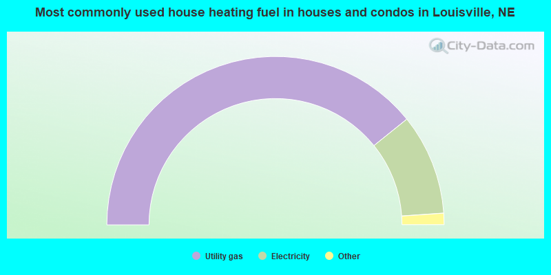
- 78.8%Utility gas
- 19.5%Electricity
- 1.0%Other fuel
- 0.7%Bottled, tank, or LP gas
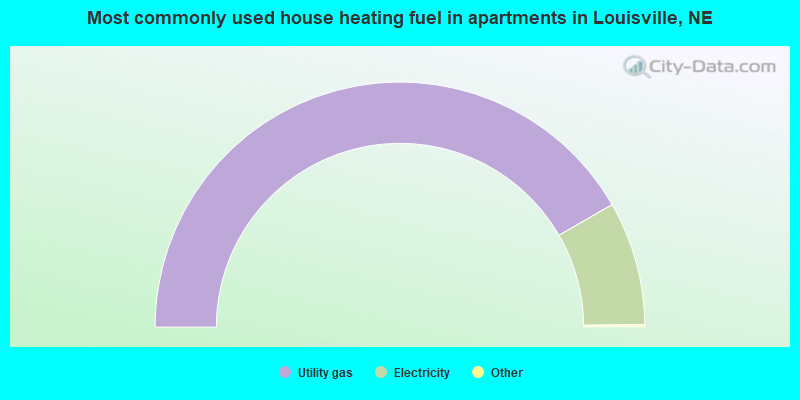
- 83.6%Utility gas
- 16.4%Electricity
Louisville compared to Nebraska state average:
- Unemployed percentage significantly below state average.
- Black race population percentage significantly below state average.
- Hispanic race population percentage significantly below state average.
- Median age below state average.
- Foreign-born population percentage significantly below state average.
- Length of stay since moving in significantly above state average.
- Percentage of population with a bachelor's degree or higher above state average.

|
Total of 3 patent applications in 2008-2024.