Lower Trinity, California
Submit your own pictures of this place and show them to the world
- OSM Map
- General Map
- Google Map
- MSN Map

| Males: 1,128 | |
| Females: 1,095 |
| Median resident age: | 44.9 years |
| California median age: | 33.3 years |
Zip code: 96010
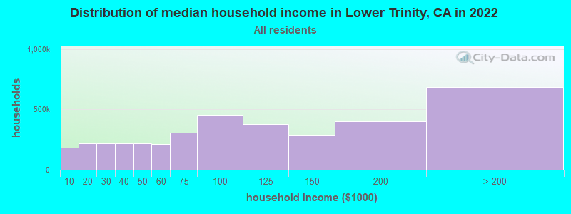
| Lower Trinity: | $45,323 |
| CA: | $91,551 |
Estimated per capita income in 2022: $30,760 (it was $15,430 in 2000)
Lower Trinity CCD income, earnings, and wages data
Estimated median house or condo value in 2022: $385,407 (it was $112,400 in 2000)
| Lower Trinity: | $385,407 |
| CA: | $715,900 |
Mean prices in 2022: all housing units: $643,405; detached houses: $736,800; townhouses or other attached units: $456,127; mobile homes: $217,236; occupied boats, rvs, vans, etc.: $119,708
Detailed information about poverty and poor residents in Lower Trinity, CA


- 1,76084.8%White alone
- 1487.1%American Indian alone
- 964.6%Two or more races
- 612.9%Hispanic
- 40.2%Asian alone
- 40.2%Native Hawaiian and Other
Pacific Islander alone - 30.1%Black alone

 Recent articles from our blog. Our writers, many of them Ph.D. graduates or candidates, create easy-to-read articles on a wide variety of topics.

Current Local Time: PST time zone
Land area: 749.7 square miles.
Population density: 3.0 people per square mile (very low).
| Lower Trinity CCD: | 0.7% ($816) |
| California: | 0.8% ($1,564) |
Nearest city with pop. 50,000+: Redding, CA  (51.8 miles , pop. 80,865).
Nearest city with pop. 200,000+: Sacramento, CA (184.5 miles , pop. 407,018).
Nearest city with pop. 1,000,000+: Los Angeles, CA (538.4 miles , pop. 3,694,820).
Nearest cities:
), ), ), ), )Latitude: 40.82 N, Longitude: 123.30 W
Area code commonly used in this area: 530

| Here: | 6.3% |
| California: | 5.1% |

- Educational services (9.4%)
- Agriculture, forestry, fishing & hunting (9.1%)
- Administrative & support & waste management services (8.6%)
- Health care (7.2%)
- Public administration (7.2%)
- Construction (5.9%)
- Gasoline stations (5.8%)

- Agriculture, forestry, fishing & hunting (16.5%)
- Administrative & support & waste management services (10.2%)
- Public administration (9.9%)
- Construction (8.2%)
- Petroleum & petroleum products merchant wholesalers (5.7%)
- Educational services (5.1%)
- Wood products (4.8%)

- Educational services (13.9%)
- Health care (12.4%)
- Social assistance (8.9%)
- Accommodation & food services (8.6%)
- Gasoline stations (6.8%)
- Administrative & support & waste management services (6.8%)
- Food & beverage stores (6.2%)

- Building and grounds cleaning and maintenance occupations (7.2%)
- Driver/sales workers and truck drivers (5.2%)
- Other management occupations, except farmers and farm managers (4.3%)
- Other sales and related occupations, including supervisors (4.3%)
- Cashiers (3.9%)
- Other production occupations, including supervisors (3.9%)
- Agricultural workers, including supervisors (3.9%)

- Building and grounds cleaning and maintenance occupations (9.9%)
- Driver/sales workers and truck drivers (9.4%)
- Other production occupations, including supervisors (7.7%)
- Agricultural workers, including supervisors (6.8%)
- Other sales and related occupations, including supervisors (6.2%)
- Other transportation occupations (5.1%)
- Fire fighting and prevention workers, including supervisors (4.3%)

- Bookkeeping, accounting, and auditing clerks (6.8%)
- Cooks and food preparation workers (5.9%)
- Material recording, scheduling, dispatching, and distributing workers (5.6%)
- Cashiers (5.3%)
- Other management occupations, except farmers and farm managers (4.7%)
- Preschool, kindergarten, elementary, and middle school teachers (4.4%)
- Building and grounds cleaning and maintenance occupations (4.4%)
Average climate in Lower Trinity, California
Based on data reported by over 4,000 weather stations


(lower is better)

Air Quality Index (AQI) level in 2023 was 96.4. This is worse than average.
| City: | 96.4 |
| U.S.: | 72.6 |

Particulate Matter (PM10) [µg/m3] level in 2002 was 15.6. This is better than average. Closest monitor was 19.9 miles away from the city center.
| City: | 15.6 |
| U.S.: | 19.2 |

Particulate Matter (PM2.5) [µg/m3] level in 2023 was 12.5. This is significantly worse than average. Closest monitor was 19.9 miles away from the city center.
| City: | 12.5 |
| U.S.: | 8.1 |
Earthquake activity:
Lower Trinity-area historical earthquake activity is significantly above California state average. It is 4551% greater than the overall U.S. average.On 1/31/1922 at 13:17:28, a magnitude 7.6 (7.6 UK, Class: Major, Intensity: VIII - XII) earthquake occurred 118.1 miles away from Lower Trinity center
On 4/18/1906 at 13:12:21, a magnitude 7.9 (7.9 UK) earthquake occurred 195.6 miles away from Lower Trinity center, causing $524,000,000 total damage
On 4/25/1992 at 18:06:04, a magnitude 7.2 (6.3 MB, 7.1 MS, 7.2 MW, 7.1 MW, Depth: 9.4 mi) earthquake occurred 51.6 miles away from Lower Trinity center, causing $75,000,000 total damage
On 11/8/1980 at 10:27:34, a magnitude 7.2 (6.2 MB, 7.2 MS, 7.2 MW, 7.0 ML) earthquake occurred 55.7 miles away from Lower Trinity center
On 1/22/1923 at 09:04:18, a magnitude 7.2 (7.2 UK) earthquake occurred 108.4 miles away from Lower Trinity center
On 6/15/2005 at 02:50:54, a magnitude 7.2 (7.2 MW, Depth: 9.9 mi) earthquake occurred 141.9 miles away from Lower Trinity center
Magnitude types: body-wave magnitude (MB), local magnitude (ML), surface-wave magnitude (MS), moment magnitude (MW)
Natural disasters:
The number of natural disasters in Trinity County (23) is greater than the US average (15).Major Disasters (Presidential) Declared: 11
Emergencies Declared: 4
Causes of natural disasters: Floods: 16, Winter Storms: 9, Storms: 7, Landslides: 6, Mudslides: 6, Fires: 4, Drought: 1, Heavy Rain: 1, Hurricane: 1, Tornado: 1, Other: 1 (Note: some incidents may be assigned to more than one category).
Colleges/universities with over 2000 students nearest to Lower Trinity:
- Humboldt State University (about 41 miles; Arcata, CA; Full-time enrollment: 7,353)
- College of the Redwoods (about 48 miles; Eureka, CA; FT enrollment: 4,410)
- Shasta College (about 54 miles; Redding, CA; FT enrollment: 5,645)
- Southern Oregon University (about 100 miles; Ashland, OR; FT enrollment: 4,650)
- California State University-Chico (about 108 miles; Chico, CA; FT enrollment: 14,838)
- Rogue Community College (about 111 miles; Grants Pass, OR; FT enrollment: 3,600)
- Mendocino College (about 113 miles; Ukiah, CA; FT enrollment: 2,263)
Points of interest:
Notable locations in Lower Trinity: Squaw Camp (A), Bucks Ranch (B), Stonehouse (C), Stove Camp (D), Todd Cabin (E), Strunce Cabin (F), Salyer Work Center (G), White Rock City (H), Upper Waldorff Ranch (I), Rattlesnake Camp (J), Pony Camp (K), Onemile Camp (L), Brooks Ranch (M), Clems Camp (N), Denny Campground (O), Gray Falls Campground (P), Hayden Flat Campground (Q), Ladder Camp (R), Miller Ranch (S), Pigeon Point Campground (T). Display/hide their locations on the map
Lakes: Boulder Creek Lakes (A), McCartneys Pond (B), Big Lake (C), Whites Creek Lake (D), Lois Lake (E), Slattery Pond (F), L Lake (G), Kalmia Lake (H). Display/hide their locations on the map
Rivers and creeks: Eightmile Creek (A), Gas Creek (B), Hawkins Creek (C), Hudson Creek (D), Swede Creek (E), Stetson Creek (F), Squaw Creek (G), Yellow Jacket Creek (H), Smoky Camp Creek (I). Display/hide their locations on the map
Park in Lower Trinity: Helena Historic District (1). Display/hide its location on the map
| This place: | 2.3 people |
| California: | 2.9 people |
| This place: | 48.2% |
| Whole state: | 69.4% |
| This place: | 8.4% |
| Whole state: | 5.9% |
Likely homosexual households (counted as self-reported same-sex unmarried-partner households)
- Lesbian couples: 0.3% of all households
- Gay men: 0.3% of all households
| This place: | 17.8% |
| Whole state: | 14.2% |
| This place: | 7.9% |
| Whole state: | 6.3% |
For population 15 years and over in Lower Trinity:

- Never married: 18.7%
- Now married: 58.8%
- Separated: 3.9%
- Widowed: 8.7%
- Divorced: 13.9%
For population 25 years and over in Lower Trinity:
- High school or higher: 81.5%
- Bachelor's degree or higher: 13.4%
- Graduate or professional degree: 4.8%
- Unemployed: 17.1%
- Mean travel time to work (commute): 28.5 minutes


| Here: | 8.9 |
| California average: | 16.1 |
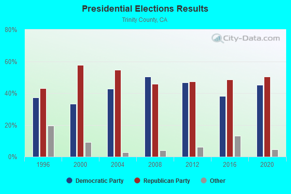
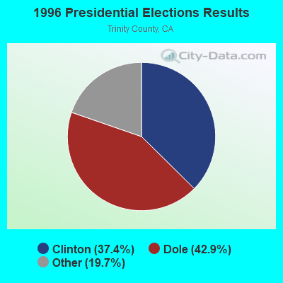
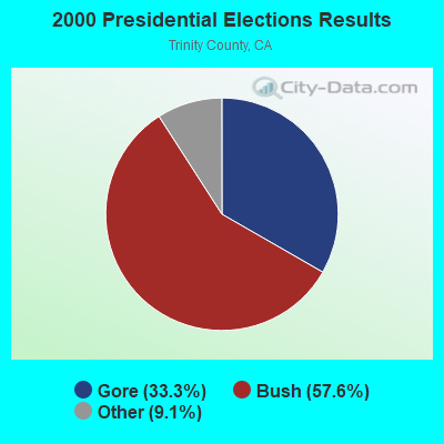
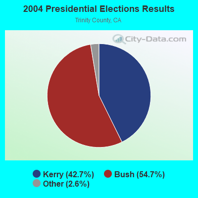
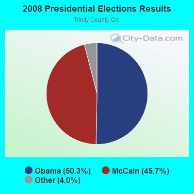
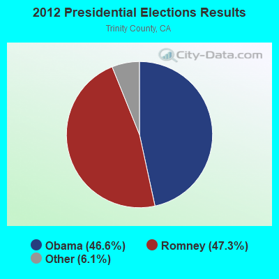
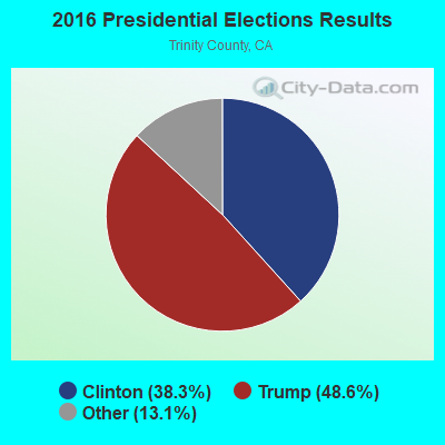
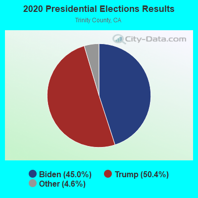
Graphs represent county-level data. Detailed 2008 Election Results
Religion statistics for Lower Trinity, CA (based on Trinity County data)
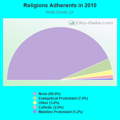
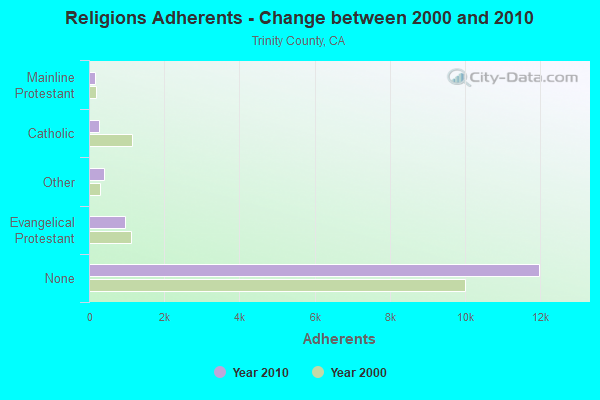
| Religion | Adherents | Congregations |
|---|---|---|
| Evangelical Protestant | 961 | 14 |
| Other | 412 | 7 |
| Catholic | 269 | 3 |
| Mainline Protestant | 166 | 2 |
| None | 11,978 | - |
Food Environment Statistics:
| Here: | 4.24 / 10,000 pop. |
| California: | 2.14 / 10,000 pop. |
| This county: | 2.12 / 10,000 pop. |
| California: | 0.62 / 10,000 pop. |
| Here: | 6.36 / 10,000 pop. |
| California: | 1.49 / 10,000 pop. |
| This county: | 8.49 / 10,000 pop. |
| State: | 7.42 / 10,000 pop. |
| This county: | 9.2% |
| California: | 7.3% |
| This county: | 23.2% |
| California: | 21.3% |
| This county: | 19.7% |
| California: | 17.9% |
Strongest AM radio stations in Lower Trinity:
- KNCR (1090 AM; daytime; 10 kW; FORTUNA, CA; Owner: MILLER BROADCASTING COMPANY, INC.)
- KWSW (790 AM; 5 kW; EUREKA, CA; Owner: EUREKA BROADCASTING CO., INC.)
- KINS (980 AM; 5 kW; EUREKA, CA; Owner: EUREKA BROADCASTING CO.)
- KNRO (1670 AM; 10 kW; REDDING, CA; Owner: REGENT LICENSEE OF REDDING, INC.)
- KCBS (740 AM; 50 kW; SAN FRANCISCO, CA; Owner: INFINITY BROADCASTING OPERATIONS, INC.)
- KTMT (580 AM; 10 kW; ASHLAND, OR; Owner: MAPLETON COMMUNICATIONS, LLC)
- KGOE (1480 AM; 5 kW; EUREKA, CA; Owner: BICOASTAL MEDIA LLC)
- KKOH (780 AM; 50 kW; RENO, NV; Owner: CITADEL BROADCASTING COMPANY)
- KGRV (700 AM; 25 kW; WINSTON, OR; Owner: PACIFIC CASCADE COMMUNICATIONS CORP.)
- KAPL (1300 AM; 20 kW; PHOENIX, OR; Owner: APPLEGATE MEDIA, INC.)
- KVIP (540 AM; 2 kW; REDDING, CA; Owner: PACIFIC CASCADE COMMUNICATIONS CORP.)
- KNBR (680 AM; 50 kW; SAN FRANCISCO, CA; Owner: KNBR LICO, INC.)
- KTRB (860 AM; 50 kW; MODESTO, CA; Owner: PAPPAS RADIO OF CALIFORNIA, A CALIFORNIA LIMITED PARTNERSHIP)
Strongest FM radio stations in Lower Trinity:
- K259AL (99.7 FM; WILLOW CREEK, CA; Owner: KHSU-FM, HUMBOLDT STATE UNIVERSITY)
- KHRD (103.1 FM; WEAVERVILLE, CA; Owner: RESULTS RADIO LICENSEE, LLC)
- KNCQ (97.3 FM; REDDING, CA; Owner: RESULTS RADIO OF REDDING, LLC)
- K225AJ (92.9 FM; BURNEY/REDDING, CA; Owner: CALVARY CHAPEL OF TWIN FALLS, INC.)
- K263AD (100.5 FM; WEAVERVILLE, ETC., CA; Owner: WEAVERVILLE TRANSLATOR CO., INC.)
- K211DJ (90.1 FM; ARCATA, CA; Owner: EDUCATIONAL MEDIA FOUNDATION)
- KWCA (101.1 FM; WEAVERVILLE, CA; Owner: GEORGE S. FLINN, JR.)
- KKHB (105.5 FM; EUREKA, CA; Owner: BICOASTAL MEDIA LLC)
- K232CW (94.3 FM; HAYFORK, CA; Owner: RESEARCH FOUNDATION, CALIFORNIA STATE UNIVERSITY)
- KXGO (93.1 FM; ARCATA, CA; Owner: MILLER BROADCASTING COMPANY)
- KFMI (96.3 FM; EUREKA, CA; Owner: BICOASTAL MEDIA LLC)
- KHUM (104.7 FM; GARBERVILLE, CA; Owner: LOST COAST COMMUNICATIONS, INC.)
- KLVG (103.7 FM; GARBERVILLE, CA; Owner: EDUCATIONAL MEDIA FOUNDATION)
- KMUD (91.1 FM; GARBERVILLE, CA; Owner: REDWOOD COMMUNITY RADIO, INC.)
- KRED-FM (92.3 FM; EUREKA, CA; Owner: BICOASTAL MEDIA LLC)
- K201HL (88.1 FM; GARBERVILLE, CA; Owner: CALVARY CHAPEL OF TWIN FALLS, INC.)
- KMUE (88.3 FM; EUREKA, CA; Owner: REDWOOD COMMUNITY RADIO, INC)
- KHSU-FM (90.5 FM; ARCATA, CA; Owner: HUMBOLDT STATE UNIVERSITY)
- K235AM (94.9 FM; GARBERVILLE, CA; Owner: FAMILY STATIONS, INC.)
- K282AD (104.3 FM; EUREKA, CA; Owner: LOST COAST COMMUNICATIONS, INC.)
TV broadcast stations around Lower Trinity:
- K12JL (Channel 12; BURNT RANCH, ETC., CA; Owner: POLLACK/BELZ B/CING. CO., LLC)
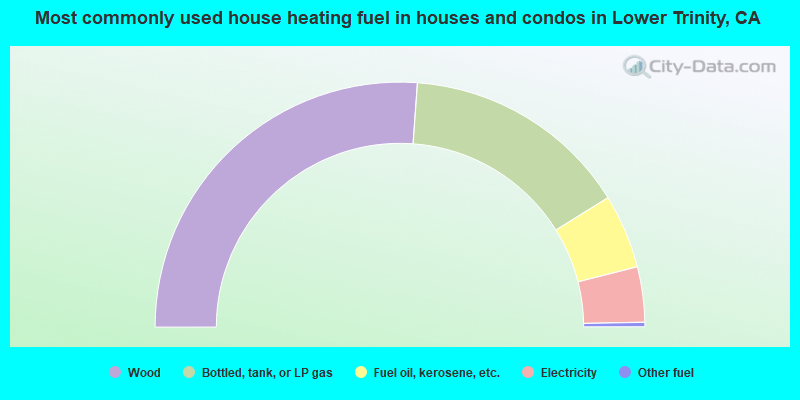
- 52.3%Wood
- 30.0%Bottled, tank, or LP gas
- 9.8%Fuel oil, kerosene, etc.
- 7.3%Electricity
- 0.6%Other fuel
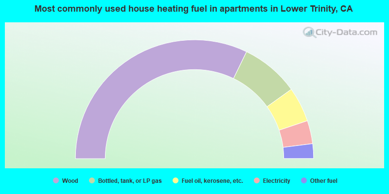
- 64.4%Wood
- 15.8%Bottled, tank, or LP gas
- 9.5%Fuel oil, kerosene, etc.
- 6.3%Electricity
- 4.0%Other fuel
Lower Trinity compared to California state average:
- Median household income below state average.
- Median house value below state average.
- Black race population percentage significantly below state average.
- Hispanic race population percentage significantly below state average.
- Median age significantly above state average.
- Foreign-born population percentage significantly below state average.
- Renting percentage significantly below state average.
- Length of stay since moving in significantly above state average.
- Number of rooms per house significantly below state average.
- House age significantly below state average.
- Number of college students below state average.
- Percentage of population with a bachelor's degree or higher below state average.
Lower Trinity on our top lists:
- #47 on the list of "Top 101 cities with the largest percentage of people in religious group quarters (population 1,000+)"
- #19 on the list of "Top 101 counties with highest percentage of residents voting for 3rd party candidates in the 2012 Presidential Election"