Lyeffion, Alabama
Submit your own pictures of this place and show them to the world
- OSM Map
- General Map
- Google Map
- MSN Map

| Males: 862 | |
| Females: 939 |
| Median resident age: | 36.8 years |
| Alabama median age: | 35.8 years |
Zip code: 36401
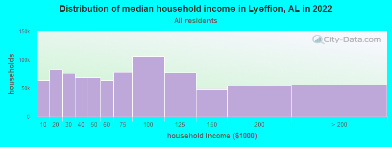
| Lyeffion: | $51,802 |
| AL: | $59,674 |
Estimated per capita income in 2022: $23,508 (it was $12,317 in 2000)
Lyeffion CCD income, earnings, and wages data
Estimated median house or condo value in 2022: $107,006 (it was $47,100 in 2000)
| Lyeffion: | $107,006 |
| AL: | $200,900 |
Detailed information about poverty and poor residents in Lyeffion, AL


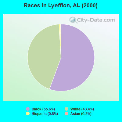
- 1,07255.6%Black alone
- 83643.4%White alone
- 150.8%Hispanic
- 30.2%Asian alone
- 10.05%American Indian alone
- 10.05%Two or more races
 Recent articles from our blog. Our writers, many of them Ph.D. graduates or candidates, create easy-to-read articles on a wide variety of topics.

Current Local Time: CST time zone
Elevation: 410 feet
Land area: 217.9 square miles.
Population density: 8.3 people per square mile (very low).

| Lyeffion CCD: | 0.4% ($199) |
| Alabama: | 0.4% ($289) |
Nearest city with pop. 50,000+: Montgomery, AL  (67.8 miles , pop. 201,568).
Nearest city with pop. 1,000,000+: Houston, TX (514.6 miles , pop. 1,953,631).
Nearest cities:
), ), ), ), ), ), ), Latitude: 31.59 N, Longitude: 87.00 W
Area code commonly used in this area: 251

| Here: | 3.8% |
| Alabama: | 2.6% |
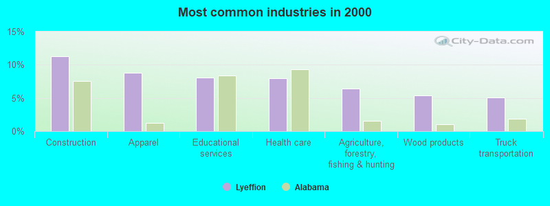
- Construction (11.3%)
- Apparel (8.8%)
- Educational services (8.1%)
- Health care (8.0%)
- Agriculture, forestry, fishing & hunting (6.5%)
- Wood products (5.4%)
- Truck transportation (5.1%)
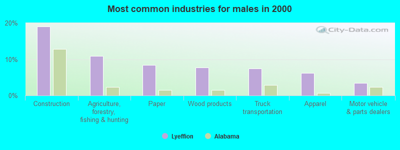
- Construction (19.0%)
- Agriculture, forestry, fishing & hunting (10.9%)
- Paper (8.4%)
- Wood products (7.7%)
- Truck transportation (7.4%)
- Apparel (6.3%)
- Motor vehicle & parts dealers (3.5%)
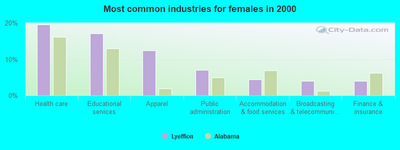
- Health care (19.5%)
- Educational services (17.2%)
- Apparel (12.5%)
- Public administration (7.1%)
- Accommodation & food services (4.4%)
- Broadcasting & telecommunications (4.0%)
- Finance & insurance (4.0%)
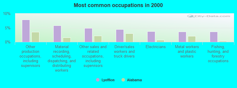
- Other production occupations, including supervisors (7.8%)
- Material recording, scheduling, dispatching, and distributing workers (5.8%)
- Other sales and related occupations, including supervisors (4.8%)
- Driver/sales workers and truck drivers (4.4%)
- Electricians (3.7%)
- Metal workers and plastic workers (3.6%)
- Fishing, hunting, and forestry occupations (3.6%)
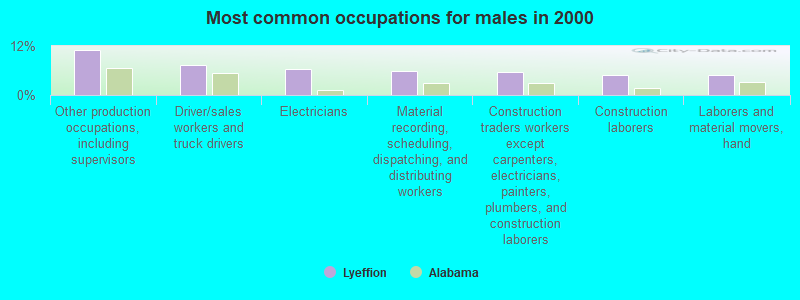
- Other production occupations, including supervisors (11.1%)
- Driver/sales workers and truck drivers (7.4%)
- Electricians (6.3%)
- Material recording, scheduling, dispatching, and distributing workers (5.8%)
- Construction traders workers except carpenters, electricians, painters, plumbers, and construction laborers (5.6%)
- Construction laborers (4.9%)
- Laborers and material movers, hand (4.9%)
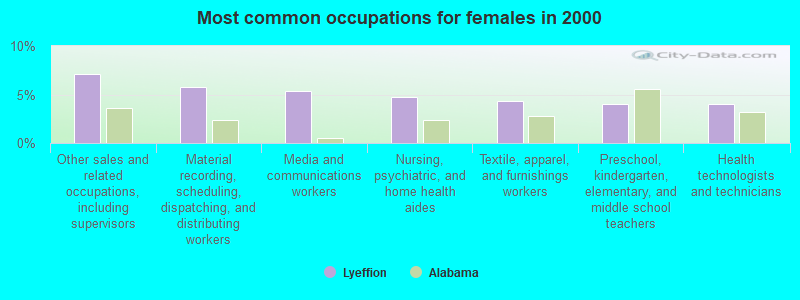
- Other sales and related occupations, including supervisors (7.1%)
- Material recording, scheduling, dispatching, and distributing workers (5.7%)
- Media and communications workers (5.4%)
- Nursing, psychiatric, and home health aides (4.7%)
- Textile, apparel, and furnishings workers (4.4%)
- Preschool, kindergarten, elementary, and middle school teachers (4.0%)
- Health technologists and technicians (4.0%)
Average climate in Lyeffion, Alabama
Based on data reported by over 4,000 weather stations


Tornado activity:
Lyeffion-area historical tornado activity is below Alabama state average. It is 30% greater than the overall U.S. average.
On 4/23/1971, a category F4 (max. wind speeds 207-260 mph) tornado 12.3 miles away from the Lyeffion place center caused between $5000 and $50,000 in damages.
On 4/18/1969, a category F4 tornado 27.1 miles away from the place center killed 2 people and injured 14 people and caused between $50,000 and $500,000 in damages.
Earthquake activity:
Lyeffion-area historical earthquake activity is significantly above Alabama state average. It is 58% greater than the overall U.S. average.On 10/24/1997 at 08:35:17, a magnitude 4.9 (4.8 MB, 4.2 MS, 4.9 LG, Depth: 6.2 mi, Class: Light, Intensity: IV - V) earthquake occurred 36.4 miles away from the city center
On 1/18/1999 at 07:00:53, a magnitude 4.8 (4.8 MB, 4.0 LG, Depth: 0.6 mi) earthquake occurred 126.2 miles away from the city center
On 11/7/2004 at 11:20:21, a magnitude 4.3 (4.3 MW, Depth: 3.1 mi) earthquake occurred 91.4 miles away from the city center
On 4/29/2003 at 08:59:39, a magnitude 4.9 (4.4 MB, 4.6 MW, 4.9 LG) earthquake occurred 215.7 miles away from the city center
On 6/24/1975 at 11:11:36, a magnitude 4.5 (4.5 MB) earthquake occurred 155.1 miles away from Lyeffion center
On 9/3/2020 at 15:07:53, a magnitude 3.8 (3.8 MW, Depth: 2.5 mi, Class: Light, Intensity: II - III) earthquake occurred 41.2 miles away from the city center
Magnitude types: regional Lg-wave magnitude (LG), body-wave magnitude (MB), surface-wave magnitude (MS), moment magnitude (MW)
Natural disasters:
The number of natural disasters in Conecuh County (19) is greater than the US average (15).Major Disasters (Presidential) Declared: 11
Emergencies Declared: 6
Causes of natural disasters: Hurricanes: 9, Storms: 7, Floods: 6, Tornadoes: 3, Winds: 2, Drought: 1, Snowfall: 1, Tropical Storm: 1, Winter Storm: 1, Other: 1 (Note: some incidents may be assigned to more than one category).
Hospitals and medical centers near Lyeffion:
- DCI EVERGREEN (Dialysis Facility, about 11 miles away; EVERGREEN, AL)
- CONECUH COUNTY HOME CARE (Home Health Center, about 11 miles away; EVERGREEN, AL)
- INFIRMARY HOSPICE CARE (Hospital, about 11 miles away; EVERGREEN, AL)
- EVERGREEN MEDICAL CENTER HOSPICE, LLC (Hospital, about 12 miles away; EVERGREEN, AL)
- EVERGREEN HOME CARE (Home Health Center, about 12 miles away; EVERGREEN, AL)
- RELIABLE HOME HEALTH (Home Health Center, about 16 miles away; GEORGIANA, AL)
- GEORGIANA HEALTH AND REHABILITATION, L L C (Nursing Home, about 16 miles away; GEORGIANA, AL)
Colleges/universities with over 2000 students nearest to Lyeffion:
- Troy University (about 64 miles; Troy, AL; Full-time enrollment: 16,148)
- Alabama State University (about 68 miles; Montgomery, AL; FT enrollment: 5,457)
- James H Faulkner State Community College (about 70 miles; Bay Minette, AL; FT enrollment: 3,703)
- Faulkner University (about 72 miles; Montgomery, AL; FT enrollment: 2,887)
- Enterprise State Community College (about 72 miles; Enterprise, AL; FT enrollment: 2,101)
- Auburn University at Montgomery (about 73 miles; Montgomery, AL; FT enrollment: 4,092)
- The University of West Florida (about 74 miles; Pensacola, FL; FT enrollment: 10,240)
Points of interest:
Notable locations in Lyeffion: Skinnerton Volunteer Fire Department (A), Lyeffion Fire Department (B). Display/hide their locations on the map
Churches in Lyeffion include: Mount Pleasant United Methodist Church (A), Mount Zion Church (B), New Haven Church of Christ (C), New Home Church (D), New Hope African Methodist Episcopal Church (E), New Hope Church (F), Pleasant Grove Church (G), Purnell Methodist Church (H), Second Mount Zion Baptist Church (I). Display/hide their locations on the map
Cemeteries: Witherington Cemetery (1), Mount Zion Cemetery (2), Martin Cemetery (3), Little Pine Level Cemetery (4), Kaiser Cemetery (5), Joyner Cemetery (6), Bethel West Cemetery (7). Display/hide their locations on the map
Reservoirs: Blackmons Pond (A), Witheringtons Pond (B), Lake Shirley (C), Alvin Mixon Lake (D). Display/hide their locations on the map
Streams, rivers, and creeks: Tigett Mill Creek (A), Spring Creek (B), Little Brushy Creek (C), East Sepulga River (D), Duck Creek (E), Horse Branch (F), West Sepulga River (G), Tomley Creek (H). Display/hide their locations on the map
| This place: | 2.4 people |
| Alabama: | 2.5 people |
| This place: | 68.7% |
| Whole state: | 67.8% |
| This place: | 3.3% |
| Whole state: | 4.7% |
Likely homosexual households (counted as self-reported same-sex unmarried-partner households)
- Lesbian couples: 0.3% of all households
- Gay men: 0.1% of all households
| This place: | 18.2% |
| Whole state: | 16.1% |
| This place: | 9.3% |
| Whole state: | 7.3% |
For population 15 years and over in Lyeffion:
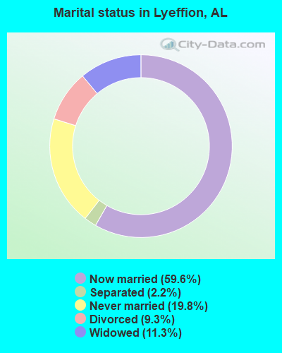
- Never married: 19.8%
- Now married: 59.6%
- Separated: 2.2%
- Widowed: 11.3%
- Divorced: 9.3%
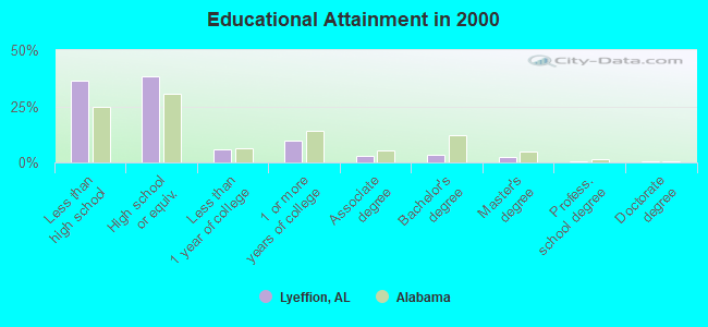
For population 25 years and over in Lyeffion:
- High school or higher: 63.7%
- Bachelor's degree or higher: 7.0%
- Graduate or professional degree: 3.5%
- Unemployed: 10.8%
- Mean travel time to work (commute): 30.4 minutes
| Here: | 11.8 |
| Alabama average: | 13.2 |
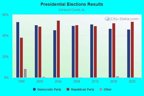
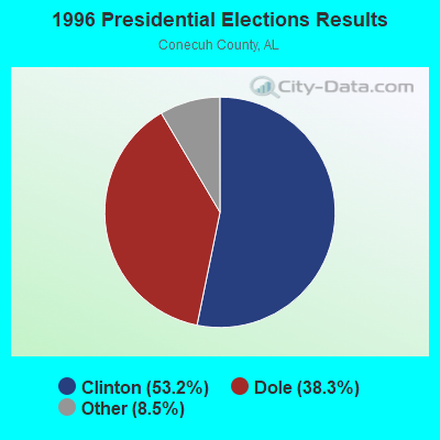
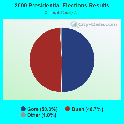
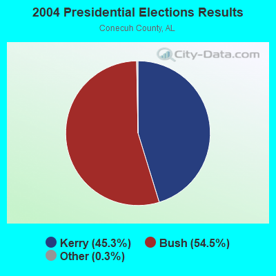
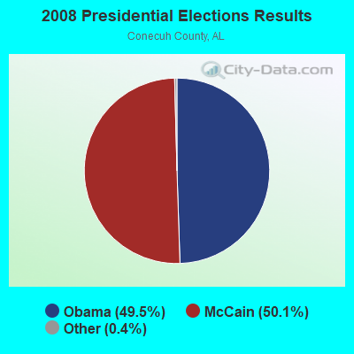
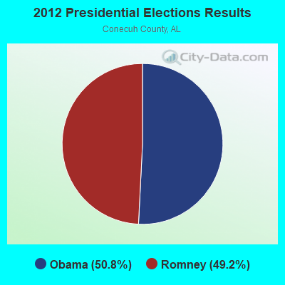
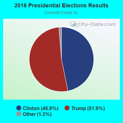
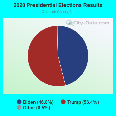
Graphs represent county-level data. Detailed 2008 Election Results
Religion statistics for Lyeffion, AL (based on Conecuh County data)
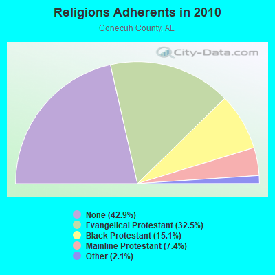
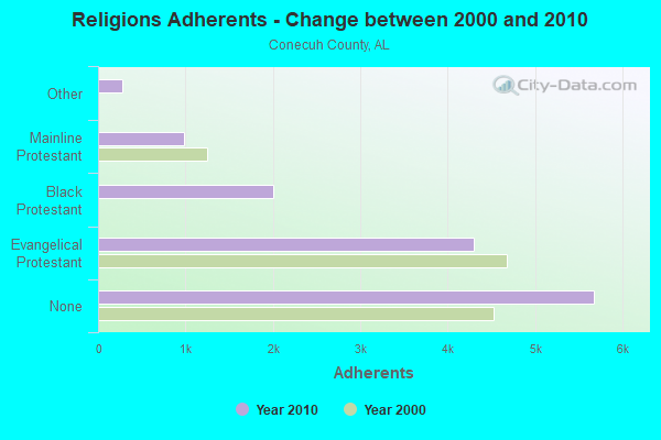
| Religion | Adherents | Congregations |
|---|---|---|
| Evangelical Protestant | 4,297 | 34 |
| Black Protestant | 2,000 | 7 |
| Mainline Protestant | 981 | 18 |
| Other | 272 | 3 |
| None | 5,678 | - |
Food Environment Statistics:
| Conecuh County: | 3.04 / 10,000 pop. |
| Alabama: | 1.89 / 10,000 pop. |
| Here: | 0.76 / 10,000 pop. |
| Alabama: | 0.65 / 10,000 pop. |
| This county: | 9.13 / 10,000 pop. |
| State: | 6.32 / 10,000 pop. |
| Conecuh County: | 3.80 / 10,000 pop. |
| State: | 5.75 / 10,000 pop. |
| Conecuh County: | 13.6% |
| Alabama: | 11.8% |
| This county: | 32.6% |
| Alabama: | 31.7% |
| This county: | 18.9% |
| Alabama: | 13.5% |
Strongest AM radio stations in Lyeffion:
- WASG (550 AM; 25 kW; ATMORE, AL; Owner: 550 AM, INC)
- WYNI (930 AM; 5 kW; MONROEVILLE, AL; Owner: MCKISSICK ENTERPRISES)
- WIJK (1470 AM; 1 kW; EVERGREEN, AL)
- WJOX (690 AM; 50 kW; BIRMINGHAM, AL; Owner: CITADEL BROADCASTING COMPANY)
- WEBY (1330 AM; 25 kW; MILTON, FL; Owner: SPINNAKER LICENSE CORPORATION)
- WDJC (850 AM; 50 kW; BIRMINGHAM, AL; Owner: KIMTRON, INC.)
- WAPI (1070 AM; 50 kW; BIRMINGHAM, AL; Owner: CITADEL BROADCASTING COMPANY)
- WSJC (810 AM; 50 kW; MAGEE, MS; Owner: FAMILY TALK RADIO)
- WMSP (740 AM; 10 kW; MONTGOMERY, AL; Owner: CUMULUS LICENSING CORP.)
- WNSI (810 AM; 50 kW; JACKSONVILLE, AL; Owner: UNITED BROADCASTING NETWORK, INC.)
- WBCA (1110 AM; daytime; 10 kW; BAY MINETTE, AL; Owner: SOUTHERN MEDIA COMMUNICATIONS, INC)
- WDLT (660 AM; 10 kW; FAIRHOPE, AL; Owner: CUMULUS LICENSING CORP.)
- WNTM (710 AM; 10 kW; MOBILE, AL; Owner: CLEAR CHANNEL BROADCASTING LICENSES, INC.)
Strongest FM radio stations in Lyeffion:
- WPGG (93.3 FM; EVERGREEN, AL; Owner: GULF COAST BROADCASTING COMPANY, INC)
- WAPR (88.3 FM; SELMA, AL; Owner: UA-ASU-TSU EDUCATIONAL RADIO CORP.)
- WELJ (90.9 FM; BREWTON, AL; Owner: GATEWAY PUBLIC RADIO)
- WFNU (101.1 FM; REPTON, AL; Owner: BRANTLEY BROADCAST ASSOCIATES)
- WQLD (104.3 FM; LUVERNE, AL; Owner: CAPSTAR TX LIMITED PARTNERSHIP)
- WZHT (105.7 FM; TROY, AL; Owner: CAPSTAR TX LIMITED PARTNERSHIP)
- WFXX (107.7 FM; GEORGIANA, AL; Owner: JEFFREY K. HAYNES)
- WGCX (95.7 FM; NAVARRE, FL; Owner: 550 AM, INC)
- WKXN (95.9 FM; GREENVILLE, AL; Owner: AUTAUGAVILLE RADIO, INC.)
- WMFC-FM (99.3 FM; MONROEVILLE, AL; Owner: MONROE BROACASTING CO., INC.)
- WTKE (98.1 FM; HOLT, FL; Owner: CAPSTAR TX LIMITED PARTNERSHIP)
TV broadcast stations around Lyeffion:
- WDIQ (Channel 2; DOZIER, AL; Owner: ALABAMA EDUCATIONAL TELEVISION COMMISSION)
- WAKA (Channel 8; SELMA, AL; Owner: ALABAMA BROADCASTING PARTNERS)
- WRJM-TV (Channel 67; TROY, AL; Owner: JOSIE PARK BROADCASTING, INC.)
- WSFA (Channel 12; MONTGOMERY, AL; Owner: LIBCO, INC.)
- WCOV-TV (Channel 20; MONTGOMERY, AL; Owner: WOODS COMMUNICATIONS CORPORATION)
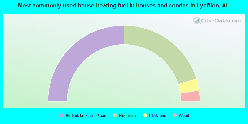
- 50.0%Bottled, tank, or LP gas
- 40.4%Electricity
- 5.2%Utility gas
- 4.5%Wood
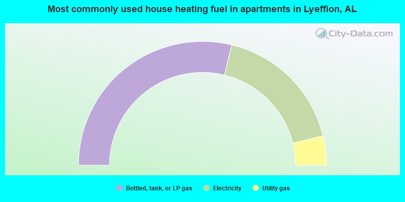
- 57.6%Bottled, tank, or LP gas
- 34.8%Electricity
- 7.6%Utility gas
Lyeffion compared to Alabama state average:
- Median house value below state average.
- Black race population percentage above state average.
- Hispanic race population percentage significantly below state average.
- Median age below state average.
- Foreign-born population percentage significantly below state average.
- Renting percentage below state average.
- Length of stay since moving in significantly above state average.
- Number of rooms per house significantly below state average.
- House age significantly below state average.
- Percentage of population with a bachelor's degree or higher significantly below state average.