Malaga, Kentucky
Submit your own pictures of this place and show them to the world
- OSM Map
- General Map
- Google Map
- MSN Map

| Males: 463 | |
| Females: 477 |
| Median resident age: | 37.4 years |
| Kentucky median age: | 35.9 years |
Zip code: 41301
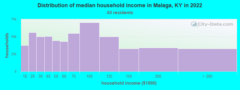
| Malaga: | $30,099 |
| KY: | $59,341 |
Estimated per capita income in 2022: $14,270 (it was $9,864 in 2000)
Malaga CCD income, earnings, and wages data
Estimated median house or condo value in 2022: $68,072 (it was $37,400 in 2000)
| Malaga: | $68,072 |
| KY: | $196,300 |
Mean prices in 2022: all housing units: $116,249; detached houses: $137,645; mobile homes: $73,872
Detailed information about poverty and poor residents in Malaga, KY


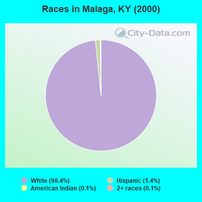
- 92298.4%White alone
- 131.4%Hispanic
- 10.1%American Indian alone
- 10.1%Two or more races
Races in Malaga detailed stats: ancestries, foreign born residents, place of birth
 Recent articles from our blog. Our writers, many of them Ph.D. graduates or candidates, create easy-to-read articles on a wide variety of topics.

Current Local Time: EST time zone
Land area: 42.8 square miles.
Population density: 22 people per square mile (very low).

| Malaga CCD: | 0.5% ($199) |
| Kentucky: | 0.8% ($610) |
Nearest city with pop. 50,000+: Fayette, KY  (59.6 miles , pop. 260,512).
Nearest city with pop. 1,000,000+: Chicago, IL (362.8 miles , pop. 2,896,016).
Nearest cities:
), ), ), ), )Latitude: 37.70 N, Longitude: 83.48 W
Area code commonly used in this area: 606

| Here: | 5.7% |
| Kentucky: | 3.8% |
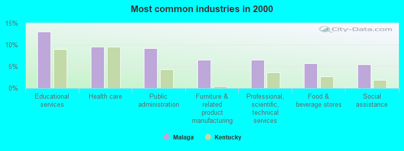
- Educational services (13.0%)
- Health care (9.5%)
- Public administration (9.2%)
- Furniture & related product manufacturing (6.5%)
- Professional, scientific, technical services (6.5%)
- Food & beverage stores (5.7%)
- Social assistance (5.4%)
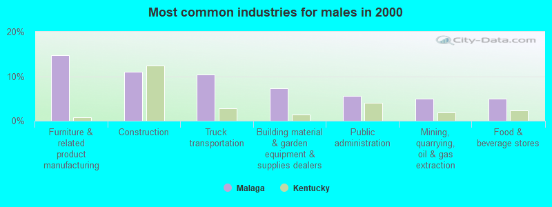
- Furniture & related product manufacturing (14.7%)
- Construction (11.0%)
- Truck transportation (10.4%)
- Building material & garden equipment & supplies dealers (7.4%)
- Public administration (5.5%)
- Mining, quarrying, oil & gas extraction (4.9%)
- Food & beverage stores (4.9%)
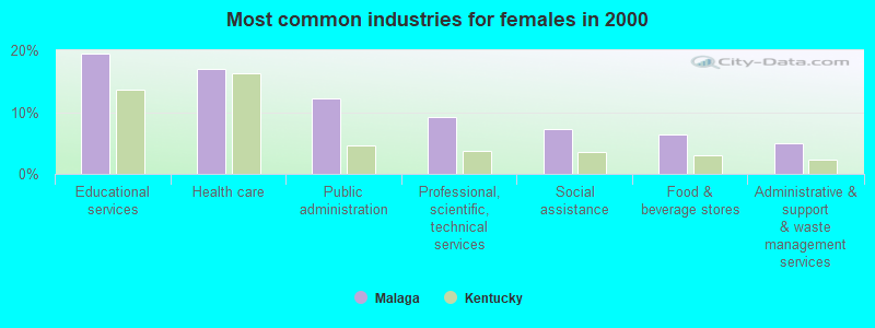
- Educational services (19.5%)
- Health care (17.1%)
- Public administration (12.2%)
- Professional, scientific, technical services (9.3%)
- Social assistance (7.3%)
- Food & beverage stores (6.3%)
- Administrative & support & waste management services (4.9%)
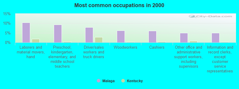
- Laborers and material movers, hand (10.3%)
- Preschool, kindergarten, elementary, and middle school teachers (9.2%)
- Driver/sales workers and truck drivers (7.9%)
- Woodworkers (6.2%)
- Cashiers (6.0%)
- Other office and administrative support workers, including supervisors (4.9%)
- Information and record clerks, except customer service representatives (4.9%)
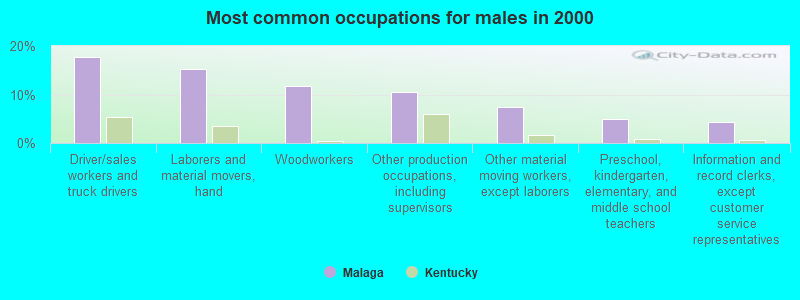
- Driver/sales workers and truck drivers (17.8%)
- Laborers and material movers, hand (15.3%)
- Woodworkers (11.7%)
- Other production occupations, including supervisors (10.4%)
- Other material moving workers, except laborers (7.4%)
- Preschool, kindergarten, elementary, and middle school teachers (4.9%)
- Information and record clerks, except customer service representatives (4.3%)
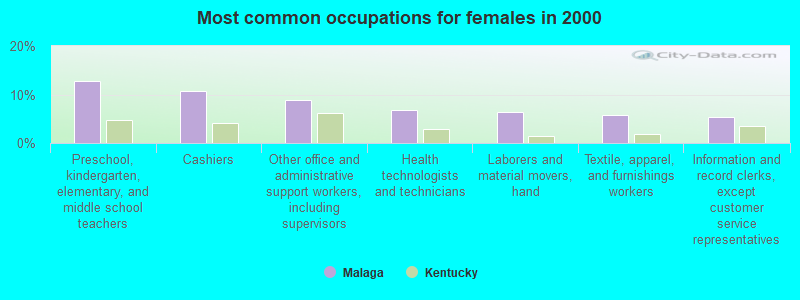
- Preschool, kindergarten, elementary, and middle school teachers (12.7%)
- Cashiers (10.7%)
- Other office and administrative support workers, including supervisors (8.8%)
- Health technologists and technicians (6.8%)
- Laborers and material movers, hand (6.3%)
- Textile, apparel, and furnishings workers (5.9%)
- Information and record clerks, except customer service representatives (5.4%)
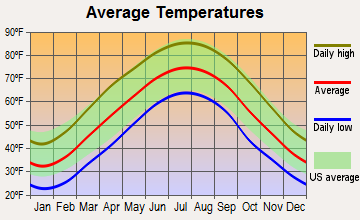
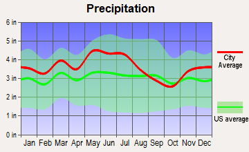
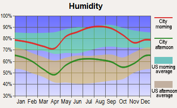
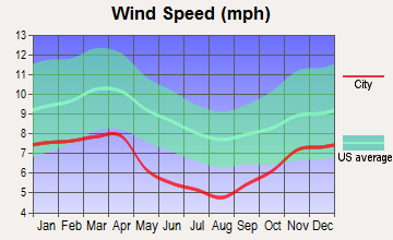
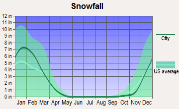
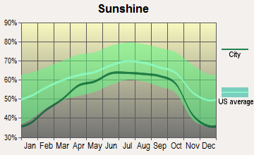
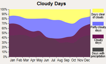
Average climate in Malaga, Kentucky
Based on data reported by over 4,000 weather stations
Tornado activity:
Malaga-area historical tornado activity is significantly below Kentucky state average. It is 41% smaller than the overall U.S. average.
On 6/9/1961, a category F3 (max. wind speeds 158-206 mph) tornado 15.8 miles away from the Malaga place center killed one person and injured 63 people and caused between $500,000 and $5,000,000 in damages.
On 4/3/1974, a category F4 (max. wind speeds 207-260 mph) tornado 39.2 miles away from the place center killed 7 people and injured 28 people.
Earthquake activity:
Malaga-area historical earthquake activity is significantly above Kentucky state average. It is 45% greater than the overall U.S. average.On 7/27/1980 at 18:52:21, a magnitude 5.2 (5.1 MB, 4.7 MS, 5.0 UK, 5.2 UK, Class: Moderate, Intensity: VI - VII) earthquake occurred 42.8 miles away from the city center
On 9/7/1988 at 02:28:09, a magnitude 4.6 (4.5 MB, 4.6 LG, Class: Light, Intensity: IV - V) earthquake occurred 37.3 miles away from the city center
On 8/9/2020 at 12:07:37, a magnitude 5.1 (5.1 MW, Depth: 4.7 mi) earthquake occurred 156.8 miles away from Malaga center
On 8/23/2011 at 17:51:04, a magnitude 5.8 (5.8 MW, Depth: 3.7 mi) earthquake occurred 303.5 miles away from Malaga center
On 4/18/2008 at 09:36:59, a magnitude 5.4 (5.1 MB, 4.8 MS, 5.4 MW, 5.2 MW) earthquake occurred 245.2 miles away from the city center
On 11/30/1973 at 07:48:41, a magnitude 4.7 (4.7 MB, 4.6 ML) earthquake occurred 134.3 miles away from Malaga center
Magnitude types: regional Lg-wave magnitude (LG), body-wave magnitude (MB), local magnitude (ML), surface-wave magnitude (MS), moment magnitude (MW)
Natural disasters:
The number of natural disasters in Wolfe County (22) is greater than the US average (15).Major Disasters (Presidential) Declared: 16
Emergencies Declared: 3
Causes of natural disasters: Floods: 14, Storms: 13, Mudslides: 7, Tornadoes: 6, Winter Storms: 6, Landslides: 5, Winds: 3, Blizzard: 1, Freeze: 1, Hurricane: 1, Snow: 1, Snowfall: 1, Snowstorm: 1, Other: 1 (Note: some incidents may be assigned to more than one category).
Colleges/universities with over 2000 students nearest to Malaga:
- Morehead State University (about 34 miles; Morehead, KY; Full-time enrollment: 7,523)
- Hazard Community and Technical College (about 37 miles; Hazard, KY; FT enrollment: 2,087)
- Big Sandy Community and Technical College (about 39 miles; Prestonsburg, KY; FT enrollment: 2,660)
- Eastern Kentucky University (about 45 miles; Richmond, KY; FT enrollment: 13,525)
- Southeast Kentucky Community and Technical College (about 58 miles; Cumberland, KY; FT enrollment: 2,196)
- Bluegrass Community and Technical College (about 60 miles; Lexington, KY; FT enrollment: 8,560)
- University of Kentucky (about 61 miles; Lexington, KY; FT enrollment: 23,517)
Points of interest:
Notable location: Bethany Children's Home (A). Display/hide its location on the map
Churches in Malaga include: Hollon Chapel (A), Hour of Harvest Church (B), Landsaw Church (C), Stillwater Old Baptist Church (D), Mission Chapel (E), Rose Dale Church (F). Display/hide their locations on the map
Cemeteries: Terrell Cemetery (1), Cash Cemetery (2), Centers-Rose Cemetery (3), Pence Cemetery (4), Murphy Cemetery (5), Hollon Cemetery (6), Tackett-Wells Cemetery (7). Display/hide their locations on the map
Streams, rivers, and creeks: Baptist Fork (A), Bee Branch (B), Betts Branch (C), Cave Branch (D), Chambers Fork (E), Terrell Fork (F), Proffit Fork (G), Pryce Fork (H), Swango Fork (I). Display/hide their locations on the map
| This place: | 2.4 people |
| Kentucky: | 2.5 people |
| This place: | 71.0% |
| Whole state: | 66.9% |
| This place: | 4.1% |
| Whole state: | 6.4% |
Likely homosexual households (counted as self-reported same-sex unmarried-partner households)
- Lesbian couples: 0.0% of all households
- Gay men: 0.4% of all households
| This place: | 40.5% |
| Whole state: | 15.8% |
| This place: | 11.0% |
| Whole state: | 6.6% |
For population 15 years and over in Malaga:
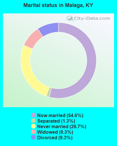
- Never married: 26.7%
- Now married: 54.6%
- Separated: 1.3%
- Widowed: 9.3%
- Divorced: 9.3%
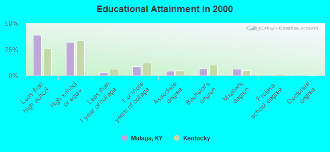
For population 25 years and over in Malaga:
- High school or higher: 61.3%
- Bachelor's degree or higher: 13.1%
- Graduate or professional degree: 6.2%
- Unemployed: 7.5%
- Mean travel time to work (commute): 32.3 minutes
| Here: | 18.5 |
| Kentucky average: | 13.8 |
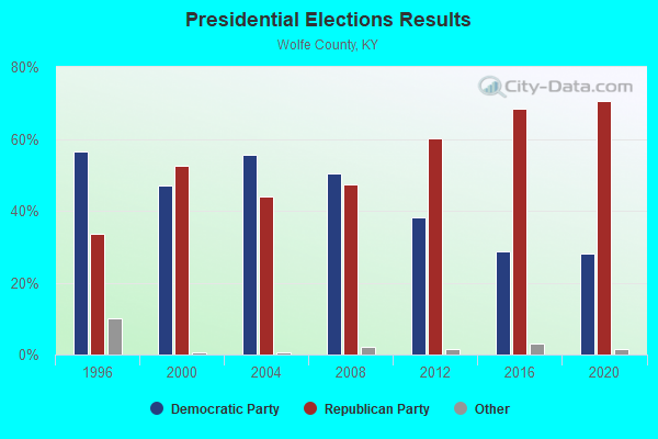
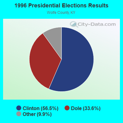
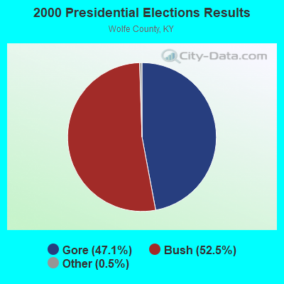
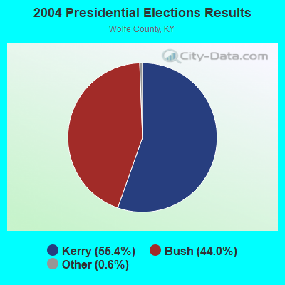
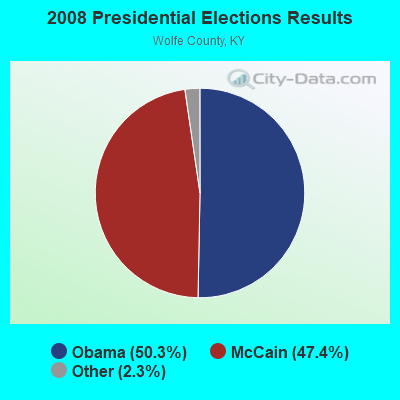

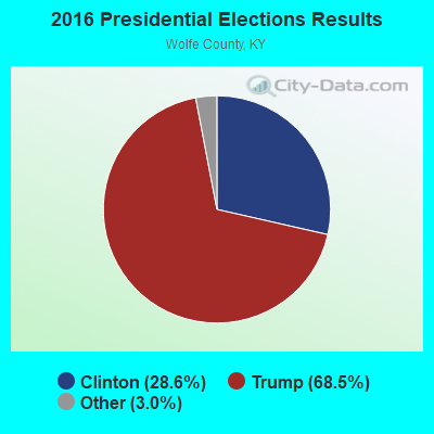
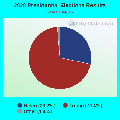
Graphs represent county-level data. Detailed 2008 Election Results
Religion statistics for Malaga, KY (based on Wolfe County data)
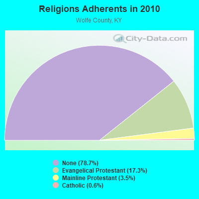
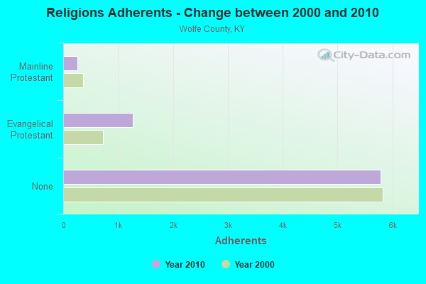
| Religion | Adherents | Congregations |
|---|---|---|
| Evangelical Protestant | 1,270 | 13 |
| Mainline Protestant | 257 | 3 |
| Catholic | 42 | 1 |
| Other | 1 | - |
| None | 5,785 | - |
Food Environment Statistics:
| Wolfe County: | 4.26 / 10,000 pop. |
| State: | 2.19 / 10,000 pop. |
| Wolfe County: | 1.42 / 10,000 pop. |
| State: | 0.74 / 10,000 pop. |
| This county: | 2.84 / 10,000 pop. |
| Kentucky: | 4.36 / 10,000 pop. |
| Wolfe County: | 1.42 / 10,000 pop. |
| Kentucky: | 5.74 / 10,000 pop. |
| Wolfe County: | 11.8% |
| Kentucky: | 11.0% |
| This county: | 31.4% |
| Kentucky: | 30.0% |
| Wolfe County: | 18.5% |
| State: | 15.9% |
Strongest AM radio stations in Malaga:
- WMTC (730 AM; 5 kW; VANCLEVE, KY; Owner: THE KENTUCKY MOUNTAIN HOLINESS ASSN.)
- WEKG (810 AM; daytime; 5 kW; JACKSON, KY; Owner: INTERMOUNTAIN B/CING CO., INC.)
- WKYH (600 AM; 5 kW; PAINTSVILLE, KY; Owner: HIGHLANDS BROADCASTING CORPORATION)
- WHAS (840 AM; 50 kW; LOUISVILLE, KY; Owner: CLEAR CHANNEL BROADCASTING LICENSES, INC.)
- WLW (700 AM; 50 kW; CINCINNATI, OH; Owner: JACOR BROADCASTING CORPORATION)
- WTVN (610 AM; 50 kW; COLUMBUS, OH; Owner: CITICASTERS LICENSES, L.P.)
- WKVL (850 AM; daytime; 50 kW; KNOXVILLE, TN; Owner: HORNE RADIO, LLC)
- WPRT (960 AM; 5 kW; PRESTONSBURG, KY; Owner: EAST KENTUCKY RADIO NETWORK, INC.)
- WKIC (1390 AM; 5 kW; HAZARD, KY)
- WSAI (1530 AM; 50 kW; CINCINNATI, OH; Owner: JACOR BROADCASTING CORPORATION)
- WDOC (1310 AM; 5 kW; PRESTONSBURG, KY)
- WKLB (1290 AM; 5 kW; MANCHESTER, KY; Owner: BARKER BROADCASTING COMPANY, INC.)
- WLAP (630 AM; 5 kW; LEXINGTON, KY; Owner: CITICASTERS LICENSES, L.P.)
Strongest FM radio stations in Malaga:
- WCBJ (103.7 FM; CAMPTON, KY; Owner: MORGAN COUNTY INDUSTRIES INC)
- WJSN-FM (106.5 FM; JACKSON, KY; Owner: INTERMOUNTAIN BROADCASTING CO.)
- WMTC-FM (99.9 FM; VANCLEVE, KY; Owner: KENTUCKY MOUNTAIN HOLINESS ASSOC.)
- WLJC (102.1 FM; BEATTYVILLE, KY; Owner: HOUR OF HARVEST, INCORPORATED)
- WSKV-FM (104.9 FM; STANTON, KY; Owner: PARKS BROADCASTING, INC.)
- WSGS (101.1 FM; HAZARD, KY; Owner: MOUNTAIN BROADCASTING SERVICE, INC.)
- WZQQ (97.9 FM; HYDEN, KY; Owner: LESLIE COUNTY BROADCASTING, INC.)
- WJMD (104.7 FM; HAZARD, KY; Owner: HAZARD BROADCASTING SERVICES)
- WMKY (90.3 FM; MOREHEAD, KY; Owner: MOREHEAD STATE UNIVERSITY)
- WSEH (102.7 FM; CUMBERLAND, KY; Owner: CUMBERLAND CITY BROADCASTING, INC.)
- WEKH (90.9 FM; HAZARD, KY; Owner: EASTERN KENTUCKY UNIVERSITY)
- WOCS (88.3 FM; LEROSE, KY; Owner: BOARD OF REGENTS - MOREHEAD STATE UNIVERSITY)
- WQHY (95.5 FM; PRESTONSBURG, KY; Owner: WDOC, INC.)
- WCYO (100.7 FM; IRVINE, KY; Owner: KENTUCKY RIVER BROADCASTING CO.)
- WTBK (105.7 FM; MANCHESTER, KY; Owner: MANCHESTER COMMUNICATIONS, INC.)
- WKLW-FM (94.7 FM; PAINTSVILLE, KY; Owner: B & G BROADCASTING, INC.)
- WRLV-FM (106.5 FM; SALYERSVILLE, KY; Owner: WALLINGFORD BROADCASTING COMPANY, INC.)
- WLKS-FM (102.9 FM; WEST LIBERTY, KY; Owner: MORGAN COUNTY INDUSTRIES, INC.)
TV broadcast stations around Malaga:
- W26BK (Channel 26; TALBERT, KY; Owner: MS COMMUNICATIONS, LLC)
- W16BI (Channel 16; TALBERT, KY; Owner: MS COMMUNICATIONS, LLC)
- WUPX-TV (Channel 67; MOREHEAD, KY; Owner: PAXSON LEXINGTON LICENSE, INC.)
- WLJC-TV (Channel 65; BEATTYVILLE, KY; Owner: HOUR OF HARVEST, INC.)
- W64CM (Channel 64; TALBERT, KY; Owner: MS COMMUNICATIONS, LLC)
- W66DA (Channel 66; TALBERT, KY; Owner: MS COMMUNICATIONS, LLC)
- W54CI (Channel 54; TALBERT, KY; Owner: MS COMMUNICATIONS, LLC)
- WYMT-TV (Channel 57; HAZARD, KY; Owner: WYMT LICENSEE CORP.)
- WLEX-TV (Channel 18; LEXINGTON, KY; Owner: WLEX COMMUNICATIONS, L.L.C.)
- W24BT (Channel 24; TALBERT, KY; Owner: MS COMMUNICATIONS, LLC)
- WKMR (Channel 38; MOREHEAD, KY; Owner: KENTUCKY AUTHORITY FOR EDUCATIONAL TV)
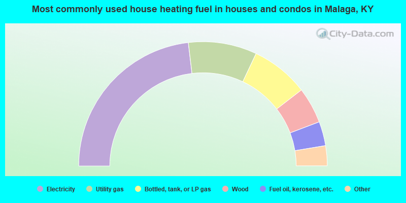
- 46.2%Electricity
- 17.8%Utility gas
- 15.0%Bottled, tank, or LP gas
- 9.4%Wood
- 6.3%Fuel oil, kerosene, etc.
- 2.8%Other fuel
- 2.4%Coal or coke
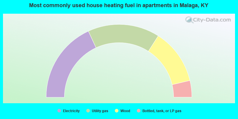
- 36.2%Electricity
- 31.9%Utility gas
- 24.5%Wood
- 7.4%Bottled, tank, or LP gas
Malaga compared to Kentucky state average:
- Median household income below state average.
- Median house value significantly below state average.
- Unemployed percentage below state average.
- Black race population percentage significantly below state average.
- Hispanic race population percentage significantly below state average.
- Foreign-born population percentage significantly below state average.
- Length of stay since moving in significantly above state average.
- Number of rooms per house significantly below state average.
- House age significantly below state average.