Mannsville, Kentucky
Submit your own pictures of this place and show them to the world
- OSM Map
- General Map
- Google Map
- MSN Map

| Males: 1,259 | |
| Females: 1,213 |
| Median resident age: | 36.3 years |
| Kentucky median age: | 35.9 years |
Zip code: 42718
| Mannsville: | $57,012 |
| KY: | $59,341 |
Estimated per capita income in 2022: $26,315 (it was $13,162 in 2000)
Mannsville CCD income, earnings, and wages data
Estimated median house or condo value in 2022: $160,731 (it was $64,700 in 2000)
| Mannsville: | $160,731 |
| KY: | $196,300 |
Mean prices in 2022: all housing units: $205,591; detached houses: $212,647; townhouses or other attached units: $214,880; in 2-unit structures: $219,199; mobile homes: $117,181
Detailed information about poverty and poor residents in Mannsville, KY


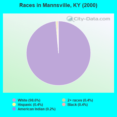
- 2,31898.6%White alone
- 90.4%Black alone
- 100.4%Two or more races
- 100.4%Hispanic
- 50.2%American Indian alone
Races in Mannsville detailed stats: ancestries, foreign born residents, place of birth
 Recent articles from our blog. Our writers, many of them Ph.D. graduates or candidates, create easy-to-read articles on a wide variety of topics.

Current Local Time: EST time zone
Elevation: 733 feet
Land area: 75.5 square miles.
Population density: 33 people per square mile (very low).

| Mannsville CCD: | 0.6% ($418) |
| Kentucky: | 0.8% ($610) |
Nearest city with pop. 50,000+: Fayette, KY  (58.0 miles , pop. 260,512).
Nearest city with pop. 1,000,000+: Chicago, IL (332.7 miles , pop. 2,896,016).
Nearest cities:
), ), ), ), )Latitude: 37.42 N, Longitude: 85.22 W
Area code commonly used in this area: 270
| Here: | 3.3% |
| Kentucky: | 3.8% |
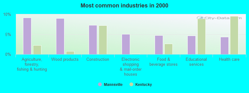
- Agriculture, forestry, fishing & hunting (9.2%)
- Wood products (9.0%)
- Construction (7.3%)
- Electronic shopping & mail-order houses (5.0%)
- Food & beverage stores (4.7%)
- Educational services (4.6%)
- Health care (4.3%)
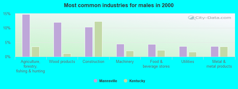
- Agriculture, forestry, fishing & hunting (14.8%)
- Wood products (12.0%)
- Construction (10.3%)
- Machinery (4.5%)
- Food & beverage stores (4.3%)
- Utilities (3.6%)
- Metal & metal products (3.6%)
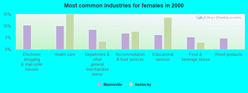
- Electronic shopping & mail-order houses (10.4%)
- Health care (10.1%)
- Department & other general merchandise stores (8.5%)
- Accommodation & food services (6.9%)
- Educational services (6.2%)
- Food & beverage stores (5.3%)
- Wood products (4.8%)
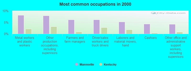
- Metal workers and plastic workers (8.2%)
- Other production occupations, including supervisors (8.0%)
- Farmers and farm managers (6.2%)
- Driver/sales workers and truck drivers (6.2%)
- Laborers and material movers, hand (5.2%)
- Cashiers (4.3%)
- Other office and administrative support workers, including supervisors (4.2%)
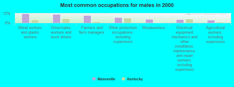
- Metal workers and plastic workers (11.7%)
- Driver/sales workers and truck drivers (10.8%)
- Farmers and farm managers (9.6%)
- Other production occupations, including supervisors (7.0%)
- Woodworkers (4.8%)
- Electrical equipment mechanics and other installation, maintenance, and repair workers, including supervisors (4.3%)
- Agricultural workers, including supervisors (3.8%)
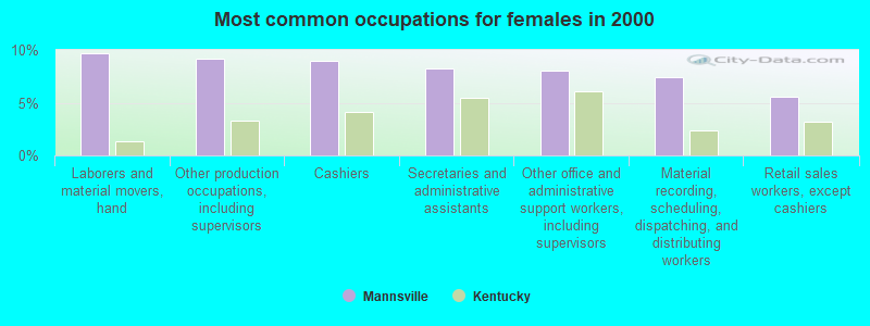
- Laborers and material movers, hand (9.7%)
- Other production occupations, including supervisors (9.2%)
- Cashiers (9.0%)
- Secretaries and administrative assistants (8.3%)
- Other office and administrative support workers, including supervisors (8.1%)
- Material recording, scheduling, dispatching, and distributing workers (7.4%)
- Retail sales workers, except cashiers (5.5%)
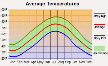
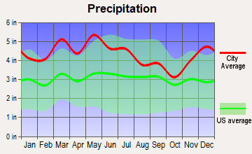
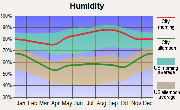
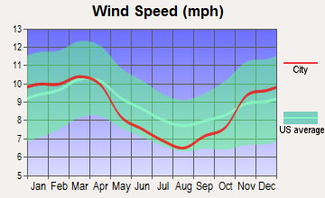
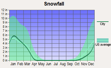
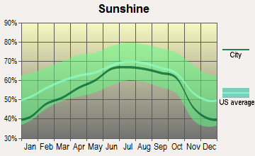
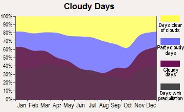
Average climate in Mannsville, Kentucky
Based on data reported by over 4,000 weather stations
Tornado activity:
Mannsville-area historical tornado activity is slightly above Kentucky state average. It is 42% greater than the overall U.S. average.
On 4/3/1974, a category F4 (max. wind speeds 207-260 mph) tornado 3.9 miles away from the Mannsville place center injured 56 people and caused between $500,000 and $5,000,000 in damages.
On 4/27/1971, a category F4 tornado 20.0 miles away from the place center killed 6 people and injured 58 people.
Earthquake activity:
Mannsville-area historical earthquake activity is significantly above Kentucky state average. It is 110% greater than the overall U.S. average.On 7/27/1980 at 18:52:21, a magnitude 5.2 (5.1 MB, 4.7 MS, 5.0 UK, 5.2 UK, Class: Moderate, Intensity: VI - VII) earthquake occurred 88.5 miles away from Mannsville center
On 4/18/2008 at 09:36:59, a magnitude 5.4 (5.1 MB, 4.8 MS, 5.4 MW, 5.2 MW) earthquake occurred 162.0 miles away from the city center
On 4/18/2008 at 09:36:59, a magnitude 5.2 (5.2 MW, Depth: 8.9 mi) earthquake occurred 162.0 miles away from Mannsville center
On 6/18/2002 at 17:37:15, a magnitude 5.0 (4.3 MB, 4.6 MW, 5.0 LG) earthquake occurred 145.5 miles away from the city center
On 6/10/1987 at 23:48:54, a magnitude 5.1 (4.9 MB, 4.4 MS, 4.6 MS, 5.1 LG) earthquake occurred 174.4 miles away from Mannsville center
On 9/7/1988 at 02:28:09, a magnitude 4.6 (4.5 MB, 4.6 LG, Class: Light, Intensity: IV - V) earthquake occurred 88.9 miles away from the city center
Magnitude types: regional Lg-wave magnitude (LG), body-wave magnitude (MB), surface-wave magnitude (MS), moment magnitude (MW)
Natural disasters:
The number of natural disasters in Taylor County (15) is near the US average (15).Major Disasters (Presidential) Declared: 11
Emergencies Declared: 3
Causes of natural disasters: Floods: 7, Storms: 6, Tornadoes: 5, Winter Storms: 4, Mudslides: 2, Blizzard: 1, Freeze: 1, Hurricane: 1, Landslide: 1, Snow: 1, Snowfall: 1, Snowstorm: 1, Wind: 1, Other: 1 (Note: some incidents may be assigned to more than one category).
Hospitals and medical centers near Mannsville:
- DAVITA - TAYLOR COUNTY DIALYSIS (Dialysis Facility, about 8 miles away; CAMPBELLSVILLE, KY)
- TAYLOR REGIONAL HOSPITAL Acute Care Hospitals (about 8 miles away; CAMPBELLSVILLE, KY)
- METZMEIER NH (Nursing Home, about 9 miles away; CAMPBELLSVILLE, KY)
- CAMPBELLSVILLE NURSING AND REHABILITATION CENTER (Nursing Home, about 11 miles away; CAMPBELLSVILLE, KY)
- CEDARS OF LEBANON NURSING CENTER (Nursing Home, about 11 miles away; LEBANON, KY)
- CEDARS OF LEBANON REST HOME (Nursing Home, about 11 miles away; LEBANON, KY)
- SPRING VIEW HOSPITAL Acute Care Hospitals (about 11 miles away; LEBANON, KY)
Colleges/universities with over 2000 students nearest to Mannsville:
- Campbellsville University (about 9 miles; Campbellsville, KY; Full-time enrollment: 2,948)
- Lindsey Wilson College (about 23 miles; Columbia, KY; FT enrollment: 2,552)
- Elizabethtown Community and Technical College (about 41 miles; Elizabethtown, KY; FT enrollment: 3,762)
- Somerset Community College (about 42 miles; Somerset, KY; FT enrollment: 4,698)
- Eastern Kentucky University (about 56 miles; Richmond, KY; FT enrollment: 13,525)
- Bluegrass Community and Technical College (about 58 miles; Lexington, KY; FT enrollment: 8,560)
- University of Kentucky (about 58 miles; Lexington, KY; FT enrollment: 23,517)
Points of interest:
Churches in Mannsville include: Farmers Chapel (A), Mount Zion Church (B), Stoner Creek Church (C). Display/hide their locations on the map
Cemeteries: Mann Cemetery (1), Stayton Cemetery (2), Hogan Cemetery (3), Tallow Creek Cemetery (4), Gaddis Ridge Cemetery (5), Saint Francis Cemetery (6), Shively Cemetery (7). Display/hide their locations on the map
Reservoirs: Sportsman Club Lake (A), Oakland Lake (B). Display/hide their locations on the map
Streams, rivers, and creeks: Opossum Branch (A), Black Lick Creek (B), Cudler Creek (C), Cotton Branch (D), Tallow Creek (E), Slate Lick Branch (F), Murrell Branch (G), Sapp Branch (H), Duton Creek (I). Display/hide their locations on the map
| This place: | 2.7 people |
| Kentucky: | 2.5 people |
| This place: | 75.2% |
| Whole state: | 66.9% |
| This place: | 6.3% |
| Whole state: | 6.4% |
Likely homosexual households (counted as self-reported same-sex unmarried-partner households)
- Lesbian couples: 0.4% of all households
- Gay men: 0.3% of all households
| This place: | 15.9% |
| Whole state: | 15.8% |
| This place: | 9.4% |
| Whole state: | 6.6% |
For population 15 years and over in Mannsville:
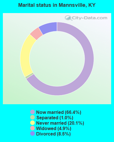
- Never married: 20.1%
- Now married: 66.4%
- Separated: 1.0%
- Widowed: 4.9%
- Divorced: 8.5%
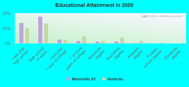
For population 25 years and over in Mannsville:
- High school or higher: 65.7%
- Bachelor's degree or higher: 5.5%
- Graduate or professional degree: 2.1%
- Unemployed: 8.2%
- Mean travel time to work (commute): 21.8 minutes
| Here: | 13.6 |
| Kentucky average: | 13.8 |
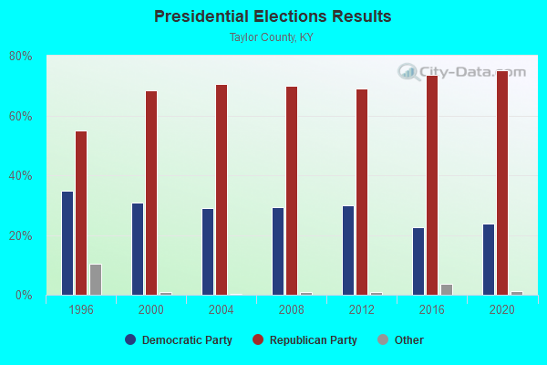
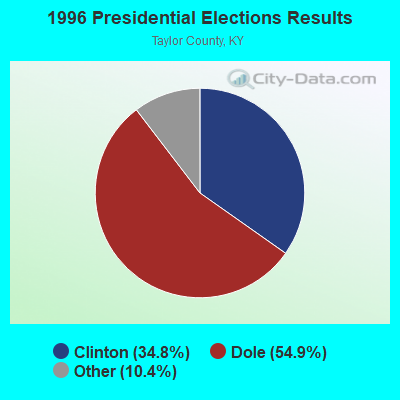


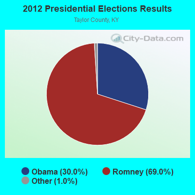
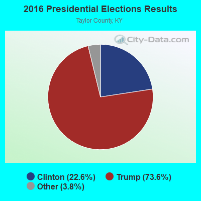
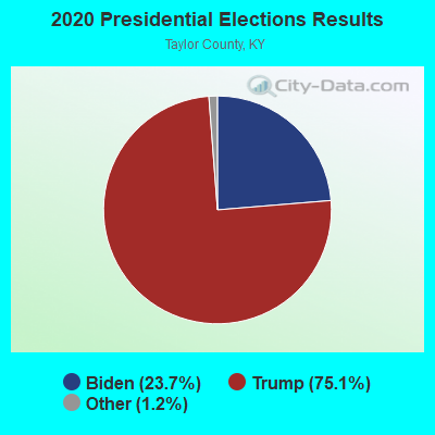
Graphs represent county-level data. Detailed 2008 Election Results
Religion statistics for Mannsville, KY (based on Taylor County data)
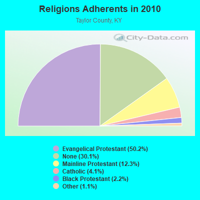
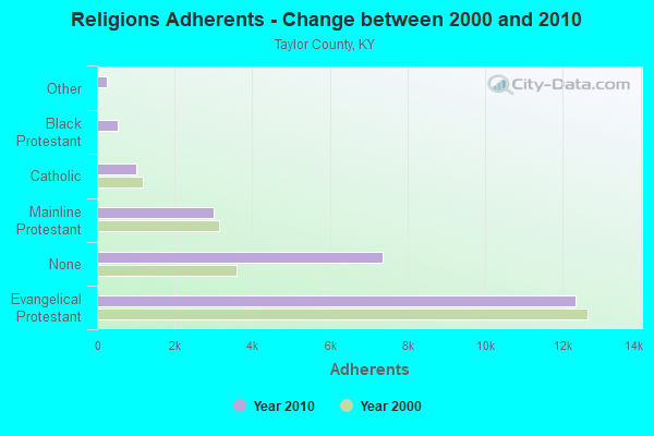
| Religion | Adherents | Congregations |
|---|---|---|
| Evangelical Protestant | 12,317 | 47 |
| Mainline Protestant | 3,008 | 18 |
| Catholic | 1,015 | 2 |
| Black Protestant | 546 | 3 |
| Other | 259 | 2 |
| None | 7,367 | - |
Food Environment Statistics:
| Here: | 3.76 / 10,000 pop. |
| Kentucky: | 2.19 / 10,000 pop. |
| This county: | 0.42 / 10,000 pop. |
| Kentucky: | 0.25 / 10,000 pop. |
| This county: | 0.42 / 10,000 pop. |
| Kentucky: | 0.74 / 10,000 pop. |
| Taylor County: | 5.86 / 10,000 pop. |
| Kentucky: | 4.36 / 10,000 pop. |
| This county: | 5.86 / 10,000 pop. |
| Kentucky: | 5.74 / 10,000 pop. |
| Taylor County: | 11.3% |
| Kentucky: | 11.0% |
| This county: | 28.3% |
| Kentucky: | 30.0% |
| Taylor County: | 14.2% |
| Kentucky: | 15.9% |
Strongest AM radio stations in Mannsville:
- WHAS (840 AM; 50 kW; LOUISVILLE, KY; Owner: CLEAR CHANNEL BROADCASTING LICENSES, INC.)
- WTCO (1450 AM; 1 kW; CAMPBELLSVILLE, KY; Owner: CBC OF MARION & TAYLOR COUNTIES INC)
- WKVL (850 AM; daytime; 50 kW; KNOXVILLE, TN; Owner: HORNE RADIO, LLC)
- WSM (650 AM; 50 kW; NASHVILLE, TN; Owner: GAYLORD ENTERTAINMENT COMPANY)
- WLBN (1590 AM; 1 kW; LEBANON, KY; Owner: CBC OF MARION COUNTY, INC)
- WLW (700 AM; 50 kW; CINCINNATI, OH; Owner: JACOR BROADCASTING CORPORATION)
- WAMB (1160 AM; 50 kW; DONELSON, TN; Owner: GREAT SOUTHERN BROADCASTING COMPANY, INC.)
- WKDA (1200 AM; 50 kW; NASHVILLE, TN; Owner: RADIO NASHVILLE, INC.)
- WLAC (1510 AM; 50 kW; NASHVILLE, TN; Owner: CAPSTAR TX LIMITED PARTNERSHIP)
- WNQM (1300 AM; 50 kW; NASHVILLE, TN; Owner: WNQM. INC.)
- WSAI (1530 AM; 50 kW; CINCINNATI, OH; Owner: JACOR BROADCASTING CORPORATION)
- WVLK (590 AM; 5 kW; LEXINGTON, KY; Owner: CUMULUS LICENSING CORP.)
- WWAM (820 AM; daytime; 50 kW; JASPER, TN; Owner: SHELTON BROADCASTING SYSTEM)
Strongest FM radio stations in Mannsville:
- WVLC (99.9 FM; MANNSVILLE, KY; Owner: PATRICIA RODGERS)
- WCKQ (104.1 FM; CAMPBELLSVILLE, KY; Owner: CBC OF MARION & TAYLOR COUNTIES INC)
- WXKY-FM (96.3 FM; STANFORD, KY; Owner: LINCOLN-GARRARD BROADCASTING CO.,INC)
- WAPD (91.7 FM; CAMPBELLSVILLE, KY; Owner: AMERICAN FAMILY ASSOCIATION)
- WDCL-FM (89.7 FM; SOMERSET, KY; Owner: WESTERN KENTUCKY UNIVERSITY)
- WAKY-FM (102.7 FM; SPRINGFIELD, KY; Owner: WASHINGTON COUNTY CBC, INC.)
- WLSK (100.9 FM; LEBANON, KY; Owner: CBC OF MARION COUNTY, INC)
- WGRK-FM (103.1 FM; GREENSBURG, KY; Owner: GREEN COUNTY CBC, INC.)
- WKDO-FM (98.7 FM; LIBERTY, KY; Owner: CARLOS D. WESLEY)
- WDFB-FM (88.1 FM; DANVILLE, KY; Owner: ALUM SPRINGS EDUCATIONAL CORPORATION)
TV broadcast stations around Mannsville:
- WBKI-TV (Channel 34; CAMPBELLSVILLE, KY; Owner: LOUISVILLE COMMUNICATIONS, LLC)
- WKSO-TV (Channel 29; SOMERSET, KY; Owner: KENTUCKY AUTHORITY FOR EDUCATIONAL TV)
- W04BP (Channel 4; CAMPBELLSVILLE, KY; Owner: CAMPSVILLE UNIVERSITY)
- WDKY-TV (Channel 56; DANVILLE, KY; Owner: WDKY LICENSEE, LLC)
- W06AY (Channel 6; LEBANON, KY; Owner: GARY WHITE)
FAA Registered Aircraft:
1- Aircraft: CESSNA R182 (Category: Land, Seats: 4, Weight: Up to 12,499 Pounds, Speed: 111 mph), Engine: LYCOMING 0-540 SERIES (250 HP) (Reciprocating)
N-Number: 9886C, N9886C, N-9886C, Serial Number: R18200482, Year manufactured: 1978, Airworthiness Date: 03/16/1980, Certificate Issue Date: 09/26/1990
Registrant (Individual): Larry B Dba Pinson, Po Box 9, Mannsville, KY 42758, Other Owners: And B Truck And Equipment Sale R
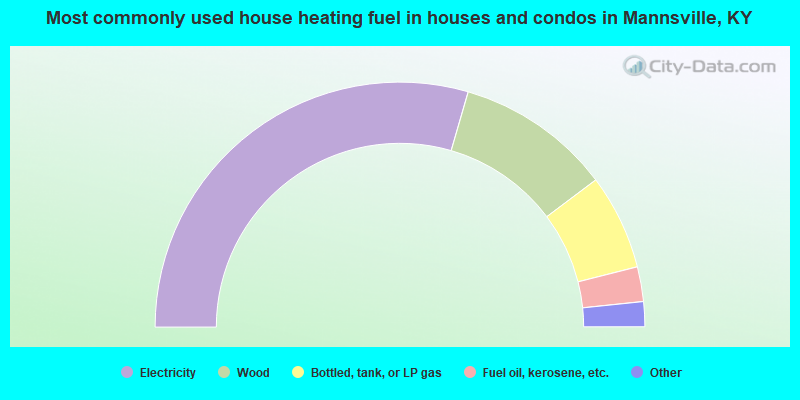
- 59.0%Electricity
- 20.5%Wood
- 12.6%Bottled, tank, or LP gas
- 4.6%Fuel oil, kerosene, etc.
- 1.2%Solar energy
- 1.0%Other fuel
- 1.0%No fuel used
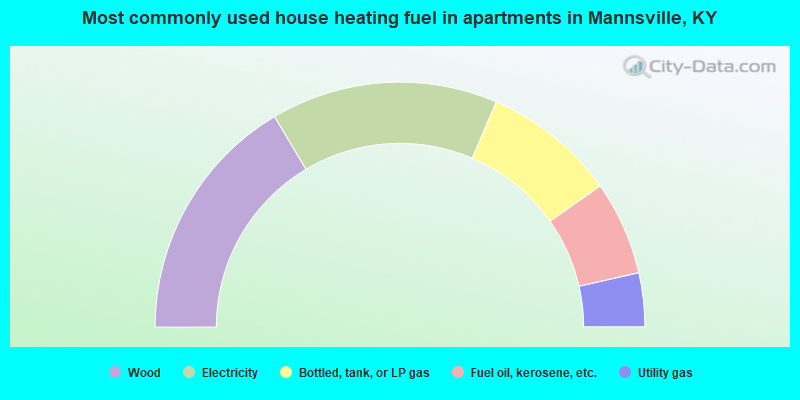
- 32.9%Wood
- 30.0%Electricity
- 17.6%Bottled, tank, or LP gas
- 12.4%Fuel oil, kerosene, etc.
- 7.1%Utility gas
Mannsville compared to Kentucky state average:
- Unemployed percentage below state average.
- Black race population percentage significantly below state average.
- Hispanic race population percentage significantly below state average.
- Median age below state average.
- Foreign-born population percentage significantly below state average.
- Renting percentage below state average.
- Length of stay since moving in significantly above state average.
- Number of rooms per house significantly below state average.
- House age significantly below state average.
- Percentage of population with a bachelor's degree or higher significantly below state average.