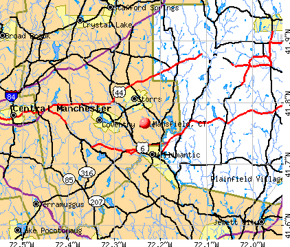
Mansfield, Connecticut
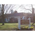
Mansfield: Town Hall
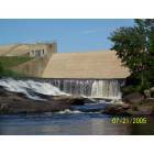
Mansfield: Mansfield Hollow Dam
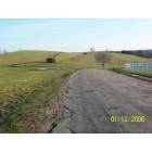
Mansfield: Horse Barn Hill

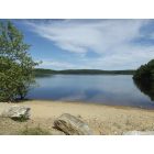
Mansfield: Eagleville Pond
Mansfield: This is where the boating dock is
- add
your


Submit your own pictures of this town and show them to the world
- OSM Map
- General Map
- Google Map
- MSN Map
Population change since 2000: +28.1%
| Males: 13,780 | |
| Females: 12,763 |
| Median resident age: | 21.5 years |
| Connecticut median age: | 39.2 years |
Zip codes: 06268.
| Mansfield: | $80,154 |
| CT: | $88,429 |
Estimated per capita income in 2022: $32,445 (it was $18,094 in 2000)
Mansfield town income, earnings, and wages data
Estimated median house or condo value in 2022: $312,610 (it was $144,600 in 2000)
| Mansfield: | $312,610 |
| CT: | $347,200 |
Mean prices in 2022: all housing units: $356,092; detached houses: $368,662; townhouses or other attached units: $222,514; in 2-unit structures: $281,599; in 3-to-4-unit structures: $156,197; in 5-or-more-unit structures: $146,539; mobile homes: $46,042
Detailed information about poverty and poor residents in Mansfield, CT
Compare current foreclosures near Mansfield, CT:
| Photo | Address | Area | Beds / Baths | Price | Details |
|---|---|---|---|---|---|

|
#1
Main St
Coventry, CT 06238
|
2,398 sq. feet
|
2 baths 3 beds |
$359,900
|
show details |

|
#2
Irving St
Manchester, CT 06042
|
1,335 sq. feet
|
2 baths 3 beds |
$265,000
|
show details |

|
#3
Tolland Ave
Stafford Springs, CT 06076
|
896 sq. feet
|
1 baths 3 beds |
$100,000
|
show details |

|
#4
Mountain Rd
Stafford Springs, CT 06076
|
1,235 sq. feet
|
2 baths 3 beds |
$299,900
|
show details |

|
#5
N Society Rd
Canterbury, CT 06331
|
768 sq. feet
|
1 baths 2 beds |
$269,900
|
show details |

|
#6
Middle Tpke E
Manchester, CT 06040
|
1,310 sq. feet
|
1 baths 4 beds |
$279,900
|
show details |

|
#7
Shares Ln
South Windsor, CT 06074
|
1,850 sq. feet
|
2 baths 4 beds |
$385,000
|
show details |

|
#8
Talcott Ave
Vernon Rockville, CT 06066
|
1,832 sq. feet
|
2 baths 4 beds |
$148,000
|
show details |

|
#9
Anthony Rd
Tolland, CT 06084
|
1,584 sq. feet
|
3 baths 4 beds |
show details | |

|
#10
Avalon Ln
Marlborough, CT 06447
|
3,740 sq. feet
|
2 baths 4 beds |
show details |
| Photo | Address | Area | Beds / Baths | Price | Details |
|---|---|---|---|---|---|

|
#11
Llynwood Dr
Bolton, CT 06043
|
1,335 sq. feet
|
1 baths 4 beds |
show details | |

|
#12
Brick Top Rd
Windham, CT 06280
|
1,077 sq. feet
|
1 baths 2 beds |
show details | |

|
#13
Circle Dr
Mansfield Center, CT 06250
|
1,152 sq. feet
|
1 baths 3 beds |
show details | |

|
#14
Park Rd
Marlborough, CT 06447
|
1,134 sq. feet
|
1 baths 3 beds |
show details | |

|
#15
Colburn Rd
Stafford Springs, CT 06076
|
1,114 sq. feet
|
1 baths 2 beds |
show details | |

|
#16
Hope Valley Rd
Amston, CT 06231
|
2,128 sq. feet
|
2 baths 3 beds |
show details | |

|
#17
Mansfield Ave
Willimantic, CT 06226
|
920 sq. feet
|
1 baths 3 beds |
show details | |

|
#18
Oakland Rd
South Windsor, CT 06074
|
1,040 sq. feet
|
1 baths 2 beds |
show details | |

|
#19
Marshall Rd
Manchester, CT 06040
|
1,314 sq. feet
|
1 baths 3 beds |
show details | |

|
#20
Rocky Hill Rd
Woodstock, CT 06281
|
1,682 sq. feet
|
1 baths 3 beds |
show details |
| Photo | Address | Area | Beds / Baths | Price | Details |
|---|---|---|---|---|---|

|
#21
Old Monson Rd
Stafford Springs, CT 06076
|
3,698 sq. feet
|
3 baths 6 beds |
show details | |

|
#22
Roberts Rd
Marlborough, CT 06447
|
1,881 sq. feet
|
1 baths 3 beds |
show details | |

|
#23
Spring St
Manchester, CT 06040
|
2,008 sq. feet
|
2 baths 3 beds |
show details | |

|
#24
Oak St
Manchester, CT 06040
|
1,879 sq. feet
|
1 baths 3 beds |
show details | |

|
#25
Potash Hill Rd
Baltic, CT 06330
|
1,028 sq. feet
|
1 baths 3 beds |
show details | |

|
#26
Campbell Dr
Canterbury, CT 06331
|
1,132 sq. feet
|
1 baths 3 beds |
show details | |

|
#27
Talcottville Rd Apt 7
Vernon Rockville, CT 06066
|
1,018 sq. feet
|
1 baths 2 beds |
show details | |

|
#28
Oak St
Manchester, CT 06040
|
1,100 sq. feet
|
1 baths 2 beds |
show details | |

|
#29
Sunset Ter
Vernon Rockville, CT 06066
|
1,052 sq. feet
|
1 baths 3 beds |
show details | |

|
#30
High St
Coventry, CT 06238
|
913 sq. feet
|
1 baths 3 beds |
show details |
| Photo | Address | Area | Beds / Baths | Price | Details |
|---|---|---|---|---|---|

|
#31
Old Town Rd Unit 75
Vernon Rockville, CT 06066
|
1,292 sq. feet
|
1 baths 2 beds |
show details | |

|
#32
Howard Dr
Vernon Rockville, CT 06066
|
3,270 sq. feet
|
4 baths 5 beds |
show details | |

|
#33
Webster Rd
Ellington, CT 06029
|
2,744 sq. feet
|
2 baths 3 beds |
show details | |

|
#34
Jericho Rd
Pomfret Center, CT 06259
|
1,154 sq. feet
|
1 baths 1 beds |
show details | |

|
#35
Alice Dr
Manchester, CT 06042
|
1,358 sq. feet
|
2 baths 2 beds |
show details | |

|
#36
Stanford Dr
Manchester, CT 06042
|
1,769 sq. feet
|
2 baths 4 beds |
show details | |

|
#37
Tufts Dr
Manchester, CT 06042
|
2,826 sq. feet
|
2 baths 4 beds |
show details | |

|
#38
Diane Dr
South Windsor, CT 06074
|
1,534 sq. feet
|
1 baths 3 beds |
show details | |

|
#39
Center St
Manchester, CT 06040
|
1,008 sq. feet
|
1 baths 3 beds |
show details | |

|
#40
Green Rd
Manchester, CT 06042
|
1,382 sq. feet
|
2 baths 3 beds |
show details |
| Photo | Address | Area | Beds / Baths | Price | Details |
|---|---|---|---|---|---|

|
#41
Homestead St
Manchester, CT 06042
|
1,403 sq. feet
|
1 baths 2 beds |
show details | |

|
#42
Main St
Somers, CT 06071
|
3,188 sq. feet
|
3 baths 5 beds |
show details | |

|
#43
Mckinley St
Manchester, CT 06040
|
1,238 sq. feet
|
1 baths 2 beds |
show details | |

|
#44
Deepwood Dr
Manchester, CT 06040
|
734 sq. feet
|
1 baths 2 beds |
show details | |

|
#45
Gorman Rd
Brooklyn, CT 06234
|
2,630 sq. feet
|
2 baths 3 beds |
show details | |

|
#46
Park Ave
Colchester, CT 06415
|
1,224 sq. feet
|
1 baths 3 beds |
show details | |

|
#47
Kathleen Way
Manchester, CT 06042
|
1,402 sq. feet
|
1 baths 3 beds |
show details | |

|
#48
Foster St
South Windsor, CT 06074
|
2,500 sq. feet
|
2 baths 3 beds |
show details | |

|
#49
Kennedy Dr
Colchester, CT 06415
|
1,132 sq. feet
|
2 baths 3 beds |
show details | |

|
Check over 1 million property listings on Foreclosure.com!
|
browse all offers | |||

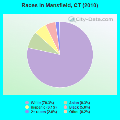
- 20,77578.3%White alone
- 2,2138.3%Asian alone
- 1,6066.1%Hispanic
- 1,3305.0%Black alone
- 5272.0%Two or more races
- 640.2%Other race alone
- 210.08%American Indian alone
- 70.03%Native Hawaiian and Other
Pacific Islander alone
Races in Mansfield detailed stats: ancestries, foreign born residents, place of birth
 Recent articles from our blog. Our writers, many of them Ph.D. graduates or candidates, create easy-to-read articles on a wide variety of topics.


Latest news from Mansfield, CT collected exclusively by city-data.com from local newspapers, TV, and radio stations
Mansfield, CT City Guides:
Ancestries: Irish (17.3%), Italian (14.6%), English (12.6%), German (12.0%), Polish (7.8%), French (7.1%).
Current Local Time: EST time zone
Incorporated on 10/1702
Elevation: 460 feet
Land area: 44.5 square miles.
Population density: 597 people per square mile (low).
2,382 residents are foreign born (6.1% Asia, 2.8% Europe, 1.6% Latin America).
| This town: | 11.5% |
| Connecticut: | 10.9% |
| Mansfield town: | 1.8% ($2,554) |
| Connecticut: | 1.8% ($2,961) |
Nearest city with pop. 50,000+: Manchester, CT  (14.8 miles , pop. 54,740).
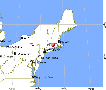
Nearest city with pop. 200,000+: Boston, MA (69.6 miles , pop. 589,141).
Nearest city with pop. 1,000,000+: Bronx, NY (107.1 miles , pop. 1,332,650).
Nearest cities:
), Latitude: 41.79 N, Longitude: 72.24 W
Area code commonly used in this area: 860


Mansfield, Connecticut accommodation & food services, waste management - Economy and Business Data
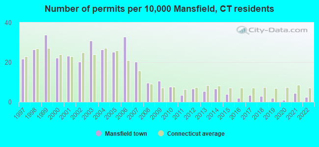
Single-family new house construction building permits:
- 2022: 5 buildings, average cost: $520,800
- 2021: 9 buildings, average cost: $332,100
- 2020: 2 buildings, average cost: $406,200
- 2019: 4 buildings, average cost: $506,500
- 2018: 6 buildings, average cost: $371,700
- 2017: 7 buildings, average cost: $346,600
- 2016: 4 buildings, average cost: $357,600
- 2015: 8 buildings, average cost: $382,500
- 2014: 14 buildings, average cost: $339,700
- 2013: 11 buildings, average cost: $394,800
- 2012: 14 buildings, average cost: $319,500
- 2011: 7 buildings, average cost: $264,000
- 2010: 16 buildings, average cost: $295,700
- 2009: 22 buildings, average cost: $241,000
- 2008: 20 buildings, average cost: $292,200
- 2007: 42 buildings, average cost: $268,600
- 2006: 68 buildings, average cost: $253,600
- 2005: 52 buildings, average cost: $259,600
- 2004: 55 buildings, average cost: $205,500
- 2003: 64 buildings, average cost: $148,800
- 2002: 42 buildings, average cost: $140,700
- 2001: 48 buildings, average cost: $140,800
- 2000: 46 buildings, average cost: $150,400
- 1999: 70 buildings, average cost: $118,900
- 1998: 55 buildings, average cost: $105,000
- 1997: 45 buildings, average cost: $105,400

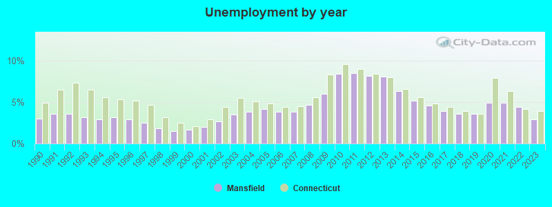
| Here: | 2.9% |
| Connecticut: | 3.9% |
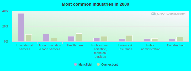
- Educational services (37.0%)
- Accommodation & food services (9.8%)
- Health care (6.8%)
- Professional, scientific, technical services (4.6%)
- Finance & insurance (3.7%)
- Public administration (3.7%)
- Construction (3.0%)
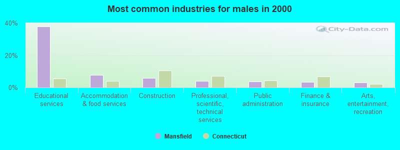
- Educational services (37.7%)
- Accommodation & food services (7.7%)
- Construction (5.9%)
- Professional, scientific, technical services (4.1%)
- Public administration (3.7%)
- Finance & insurance (3.4%)
- Arts, entertainment, recreation (3.2%)
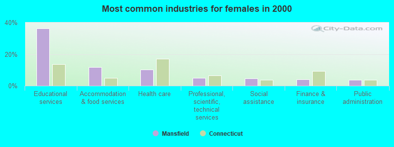
- Educational services (36.3%)
- Accommodation & food services (11.6%)
- Health care (10.2%)
- Professional, scientific, technical services (5.1%)
- Social assistance (4.6%)
- Finance & insurance (3.9%)
- Public administration (3.7%)
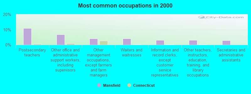
- Postsecondary teachers (11.0%)
- Other office and administrative support workers, including supervisors (6.8%)
- Other management occupations, except farmers and farm managers (4.1%)
- Waiters and waitresses (4.1%)
- Information and record clerks, except customer service representatives (3.2%)
- Other teachers, instructors, education, training, and library occupations (3.0%)
- Secretaries and administrative assistants (3.0%)
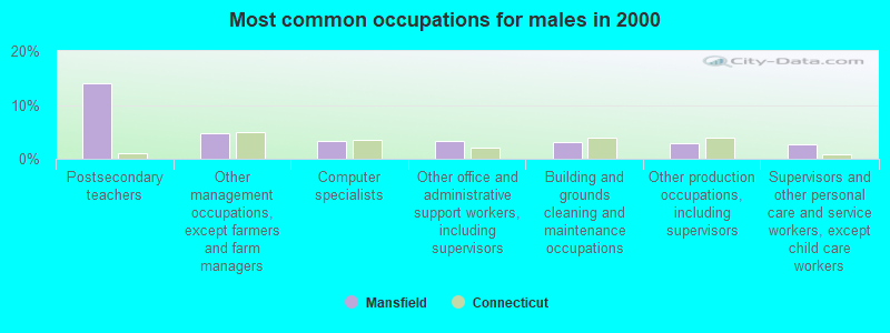
- Postsecondary teachers (14.1%)
- Other management occupations, except farmers and farm managers (4.7%)
- Computer specialists (3.3%)
- Other office and administrative support workers, including supervisors (3.2%)
- Building and grounds cleaning and maintenance occupations (3.1%)
- Other production occupations, including supervisors (2.9%)
- Supervisors and other personal care and service workers, except child care workers (2.6%)
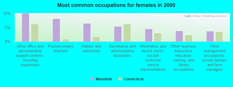
- Other office and administrative support workers, including supervisors (10.0%)
- Postsecondary teachers (8.1%)
- Waiters and waitresses (6.4%)
- Secretaries and administrative assistants (5.5%)
- Information and record clerks, except customer service representatives (4.5%)
- Other teachers, instructors, education, training, and library occupations (3.8%)
- Other management occupations, except farmers and farm managers (3.7%)
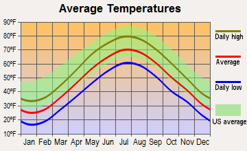
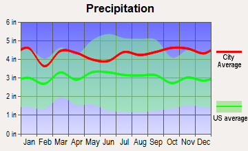
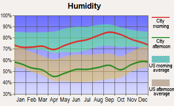
Average climate in Mansfield, Connecticut
Based on data reported by over 4,000 weather stations
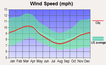
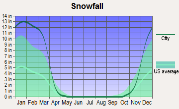
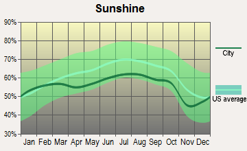
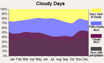
(lower is better)
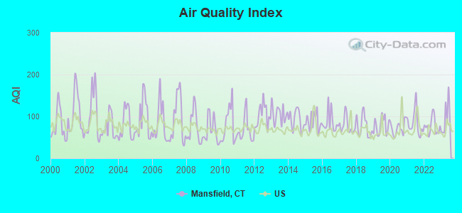
Air Quality Index (AQI) level in 2023 was 94.9. This is worse than average.
| City: | 94.9 |
| U.S.: | 72.6 |

Carbon Monoxide (CO) [ppm] level in 2022 was 0.312. This is worse than average. Closest monitor was 20.3 miles away from the city center.
| City: | 0.312 |
| U.S.: | 0.251 |
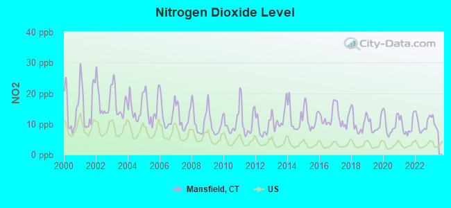
Nitrogen Dioxide (NO2) [ppb] level in 2022 was 10.1. This is significantly worse than average. Closest monitor was 1.8 miles away from the city center.
| City: | 10.1 |
| U.S.: | 5.1 |
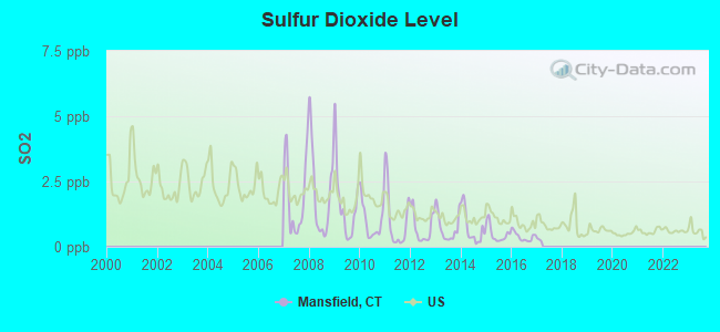
Sulfur Dioxide (SO2) [ppb] level in 2016 was 0.389. This is significantly better than average. Closest monitor was 1.8 miles away from the city center.
| City: | 0.389 |
| U.S.: | 1.515 |

Ozone [ppb] level in 2023 was 35.1. This is about average. Closest monitor was 8.7 miles away from the city center.
| City: | 35.1 |
| U.S.: | 33.3 |
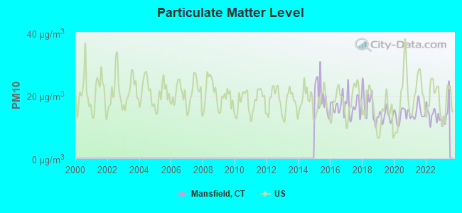
Particulate Matter (PM10) [µg/m3] level in 2022 was 13.8. This is better than average. Closest monitor was 19.1 miles away from the city center.
| City: | 13.8 |
| U.S.: | 19.2 |
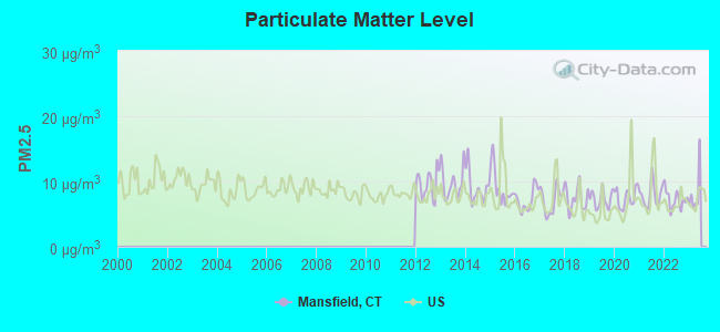
Particulate Matter (PM2.5) [µg/m3] level in 2022 was 7.25. This is about average. Closest monitor was 20.1 miles away from the city center.
| City: | 7.25 |
| U.S.: | 8.11 |
Tornado activity:
Mansfield-area historical tornado activity is near Connecticut state average. It is 25% smaller than the overall U.S. average.
On 10/3/1979, a category F4 (max. wind speeds 207-260 mph) tornado 23.2 miles away from the Mansfield town center killed 3 people and injured 500 people and caused between $50,000,000 and $500,000,000 in damages.
On 5/10/1954, a category F3 (max. wind speeds 158-206 mph) tornado 15.0 miles away from the town center injured 2 people and caused between $5000 and $50,000 in damages.
Earthquake activity:
Mansfield-area historical earthquake activity is significantly above Connecticut state average. It is 71% smaller than the overall U.S. average.On 10/7/1983 at 10:18:46, a magnitude 5.3 (5.1 MB, 5.3 LG, 5.1 ML, Class: Moderate, Intensity: VI - VII) earthquake occurred 183.8 miles away from Mansfield center
On 4/20/2002 at 10:50:47, a magnitude 5.3 (5.3 ML, Depth: 3.0 mi) earthquake occurred 202.3 miles away from the city center
On 4/20/2002 at 10:50:47, a magnitude 5.2 (5.2 MB, 4.2 MS, 5.2 MW, 5.0 MW) earthquake occurred 201.0 miles away from Mansfield center
On 1/19/1982 at 00:14:42, a magnitude 4.7 (4.5 MB, 4.7 MD, 4.5 LG, Class: Light, Intensity: IV - V) earthquake occurred 122.8 miles away from Mansfield center
On 10/16/2012 at 23:12:25, a magnitude 4.7 (4.7 ML, Depth: 10.0 mi) earthquake occurred 148.7 miles away from Mansfield center
On 8/22/1992 at 12:20:32, a magnitude 4.8 (4.8 MB, 3.8 MS, 4.7 LG, Depth: 6.2 mi) earthquake occurred 211.2 miles away from the city center
Magnitude types: regional Lg-wave magnitude (LG), body-wave magnitude (MB), duration magnitude (MD), local magnitude (ML), surface-wave magnitude (MS), moment magnitude (MW)
Natural disasters:
The number of natural disasters in Tolland County (24) is greater than the US average (15).Major Disasters (Presidential) Declared: 13
Emergencies Declared: 11
Causes of natural disasters: Hurricanes: 6, Snowstorms: 5, Storms: 5, Blizzards: 3, Floods: 3, Snows: 3, Winter Storms: 3, Snowfall: 1, Tropical Storm: 1, Wind: 1, Other: 1 (Note: some incidents may be assigned to more than one category).

Hospitals and medical centers in Mansfield:
Other hospitals and medical centers near Mansfield:
- NATCHAUG HOSPITAL (Hospital, about 4 miles away; MANSFIELD CENTER, CT)
- VNA EAST INC (Home Health Center, about 5 miles away; MANSFIELD CENTER, CT)
- VISITING NRS AND COMM HEALTH OF (Hospital, about 5 miles away; MANSFIELD CENTER, CT)
- REGENCY HEIGHTS OF WINDHAM, LLC (Nursing Home, about 5 miles away; WILLIMANTIC, CT)
- WINDHAM COMM MEM HOSP & HATCH HOSP Acute Care Hospitals (about 5 miles away; WILLIMANTIC, CT)
- ST JOSEPHS LIVING CENTER (Nursing Home, about 6 miles away; WINDHAM, CT)
- DOUGLAS MANOR (Nursing Home, about 7 miles away; WINDHAM, CT)
Colleges/universities with over 2000 students nearest to Mansfield:
- University of Connecticut (about 2 miles; Storrs, CT; Full-time enrollment: 22,037)
- Eastern Connecticut State University (about 5 miles; Willimantic, CT; FT enrollment: 4,985)
- Manchester Community College (about 17 miles; Manchester, CT; FT enrollment: 4,667)
- Three Rivers Community College (about 21 miles; Norwich, CT; FT enrollment: 2,897)
- Goodwin College (about 21 miles; East Hartford, CT; FT enrollment: 3,017)
- Capital Community College (about 23 miles; Hartford, CT; FT enrollment: 2,609)
- Trinity College (about 24 miles; Hartford, CT; FT enrollment: 2,355)
Points of interest:
Notable locations in Mansfield: Hanks Hill (A), Mansfield Fire Department Station 307 (B), Mansfield Fire Department Station 207 (C), Mansfield Fire Department Station 107 (D), University of Connecticut Fire Department (E), Mansfield Fire Marshal's Office (F). Display/hide their locations on the map
Shopping Center: East Brook Mall Shopping Center (1). Display/hide its location on the map
Cemeteries: Wormwood Hill Cemetery (1), Hillside Cemetery (2), Atwoodville Cemetery (3), Gurley Cemetery (4), Mount Hope Cemetery (5). Display/hide their locations on the map
Lakes, reservoirs, and swamps: Chapins Pond (A), Tift Pond (B), Varga Pond (C), Echo Lake (D), Hanks Hill Pond (E), Hansens Pond (F), Dunham Pond (G), Eagleville Pond (H). Display/hide their locations on the map
Streams, rivers, and creeks: Mount Hope River (A), Nelson Brook (B), Mason Brook (C), Eagleville Brook (D), Dunham Pond Brook (E), Cider Mill Brook (F), Cedar Swamp Brook (G), Schoolhouse Brook (H), Conantville Brook (I). Display/hide their locations on the map
Birthplace of: Oscar C. Badger - Navy admiral, Charles Emory Smith - Diplomat, Wilbur Lucius Cross - Politician, Hezekiah Eldredge - Architect, Jonathan Taylor (congressman) - Congressman, Joseph M. Merrow - Chief executive.
Drinking water stations with addresses in Mansfield and their reported violations in the past:
S & P PROPERTIES LLC (Population served: 42, Groundwater):Past monitoring violations:YUKON JACK'S (Population served: 25, Groundwater):
- Follow-up Or Routine LCR Tap M/R - In OCT-01-2009, Contaminant: Lead and Copper Rule. Follow-up actions: St Public Notif requested (MAR-02-2010), St Violation/Reminder Notice (MAR-02-2010), St BCA signed (MAY-16-2012), St Public Notif received (JUN-03-2012), St Compliance achieved (SEP-30-2012)
- 7 routine major monitoring violations
- 108 regular monitoring violations
Past monitoring violations:
- 4 routine major monitoring violations
- 2 regular monitoring violations
| This town: | 2.4 people |
| Connecticut: | 2.5 people |
| This town: | 56.2% |
| Whole state: | 66.3% |
| This town: | 5.4% |
| Whole state: | 6.6% |
Likely homosexual households (counted as self-reported same-sex unmarried-partner households)
- Lesbian couples: 0.8% of all households
- Gay men: 0.2% of all households
| This town: | 14.2% |
| Whole state: | 7.9% |
| This town: | 7.8% |
| Whole state: | 3.9% |
People in group quarters in Mansfield in 2010:
- 11,726 people in college/university student housing
- 1,017 people in state prisons
- 91 people in nursing facilities/skilled-nursing facilities
- 32 people in group homes intended for adults
- 20 people in residential treatment centers for adults
- 13 people in residential treatment centers for juveniles (non-correctional)
- 5 people in group homes for juveniles (non-correctional)
- 3 people in other noninstitutional facilities
People in group quarters in Mansfield in 2000:
- 7,433 people in college dormitories (includes college quarters off campus)
- 471 people in state prisons
- 86 people in nursing homes
- 4 people in homes for the mentally retarded
- 3 people in religious group quarters
Banks with branches in Mansfield (2011 data):
- Liberty Bank: Mansfield Branch at 1132 Storrs Road, branch established on 1982/09/29. Info updated 2011/01/06: Bank assets: $3,394.1 mil, Deposits: $2,747.0 mil, headquarters in Middletown, CT, positive income, Commercial Lending Specialization, 43 total offices
For population 15 years and over in Mansfield:
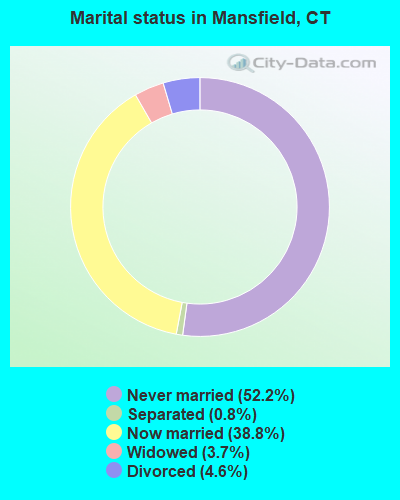
- Never married: 52.2%
- Now married: 38.8%
- Separated: 0.8%
- Widowed: 3.7%
- Divorced: 4.6%
For population 25 years and over in Mansfield:
- High school or higher: 91.3%
- Bachelor's degree or higher: 54.1%
- Graduate or professional degree: 35.4%
- Unemployed: 8.5%
- Mean travel time to work (commute): 18.3 minutes
| Here: | 13.3 |
| Connecticut average: | 12.8 |
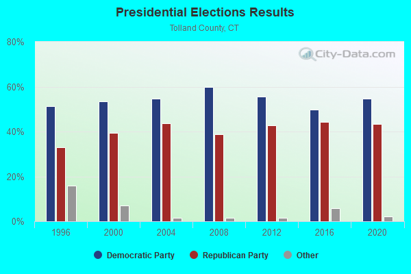
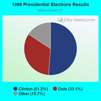
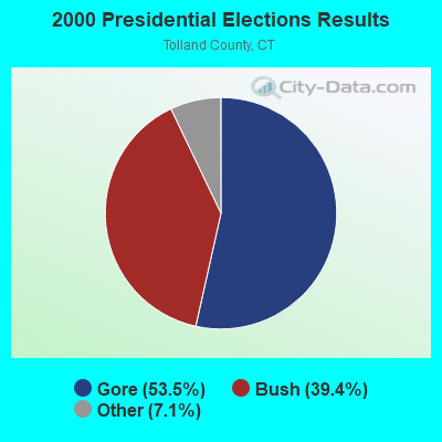
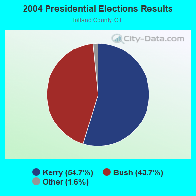
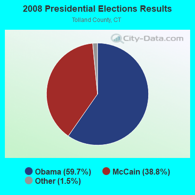
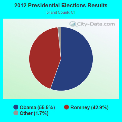
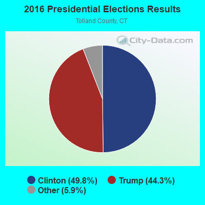
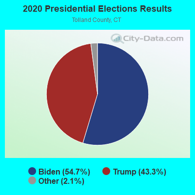
Graphs represent county-level data. Detailed 2008 Election Results
Religion statistics for Mansfield, CT (based on Tolland County data)
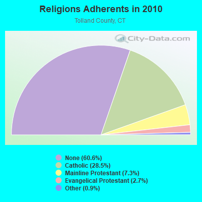
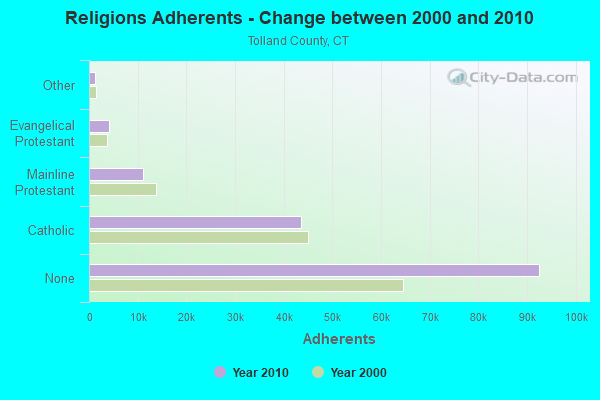
| Religion | Adherents | Congregations |
|---|---|---|
| Catholic | 43,500 | 14 |
| Mainline Protestant | 11,178 | 38 |
| Evangelical Protestant | 4,069 | 27 |
| Other | 1,302 | 8 |
| Orthodox | 100 | 1 |
| None | 92,542 | - |
Food Environment Statistics:
| This county: | 1.36 / 10,000 pop. |
| Connecticut: | 2.21 / 10,000 pop. |
| Tolland County: | 1.15 / 10,000 pop. |
| Connecticut: | 1.02 / 10,000 pop. |
| Tolland County: | 2.24 / 10,000 pop. |
| Connecticut: | 2.27 / 10,000 pop. |
| Tolland County: | 6.57 / 10,000 pop. |
| Connecticut: | 9.19 / 10,000 pop. |
| This county: | 6.2% |
| State: | 7.3% |
| This county: | 21.1% |
| State: | 21.5% |
| Tolland County: | 12.9% |
| Connecticut: | 15.8% |
| Businesses in Mansfield, CT | ||||
| Name | Count | Name | Count | |
|---|---|---|---|---|
| CVS | 1 | Staples | 1 | |
| Dunkin Donuts | 1 | UPS | 1 | |
| H&R Block | 1 | |||
Strongest AM radio stations in Mansfield:
- WTIC (1080 AM; 50 kW; HARTFORD, CT; Owner: INFINITY RADIO OPERATIONS INC.)
- WNNZ (640 AM; 50 kW; WESTFIELD, MA; Owner: CLEAR CHANNEL BROADCASTING LICENSES, INC.)
- WCRN (830 AM; 50 kW; WORCESTER, MA; Owner: CARTER BROADCASTING CORPORATION)
- WALE (990 AM; 50 kW; GREENVILLE, RI; Owner: NORTH AMERICAN BROADCASTING CO., INC.)
- WVNE (760 AM; daytime; 25 kW; LEICESTER, MA; Owner: BLOUNT MASSCOM, INC.)
- WILI (1400 AM; 1 kW; WILLIMANTIC, CT; Owner: THE NUTMEG BROADCASTING CO.)
- WEEI (850 AM; 50 kW; BOSTON, MA; Owner: ENTERCOM BOSTON LICENSE, LLC)
- WKOX (1200 AM; 50 kW; FRAMINGHAM, MA; Owner: CAPSTAR TX LIMITED PARTNERSHIP)
- WRKO (680 AM; 50 kW; BOSTON, MA; Owner: ENTERCOM BOSTON LICENSE, LLC)
- WBIX (1060 AM; 40 kW; NATICK, MA; Owner: LANGER BROADCASTING CORPORATION)
- WICH (1310 AM; 5 kW; NORWICH, CT; Owner: WICH, INCORPORATED)
- WINY (1350 AM; 5 kW; PUTNAM, CT; Owner: OSBREY BROADCASTING COMPANY)
- WAMG (890 AM; 25 kW; DEDHAM, MA; Owner: MEGA COMMUNICATIONS OF DEDHAM LICENSEE, LLC)
Strongest FM radio stations in Mansfield:
- WHUS (91.7 FM; STORRS, CT; Owner: THE BD. OF TRUSTEES, THE UNIV. OF CT)
- W258AC (99.5 FM; STORRS, CT; Owner: CONNECTICUT PUBLIC BROADCASTING, INC)
- WILI-FM (98.3 FM; WILLIMANTIC, CT; Owner: NUTMEG BROADCASTING COMPANY)
- WECS (90.1 FM; WILLIMANTIC, CT; Owner: EASTERN CONNECTICUT STATE COLLEGE)
- WRCH (100.5 FM; NEW BRITAIN, CT; Owner: INFINITY RADIO OPERATIONS INC.)
- WTIC-FM (96.5 FM; HARTFORD, CT; Owner: INFINITY RADIO OPERATIONS INC.)
- WWUH (91.3 FM; WEST HARTFORD, CT; Owner: UNIVERSITY OF HARTFORD)
- WCCC-FM (106.9 FM; HARTFORD, CT; Owner: MARLIN BROADCASTING, LLC)
- WAAF (107.3 FM; WORCESTER, MA; Owner: ENTERCOM BOSTON LICENSE, LLC)
- WWFX (100.1 FM; SOUTHBRIDGE, MA; Owner: CITADEL BROADCASTING COMPANY)
- WHYN-FM (93.1 FM; SPRINGFIELD, MA; Owner: CLEAR CHANNEL BROADCASTING LICENSES, INC.)
- WAQY (102.1 FM; SPRINGFIELD, MA; Owner: SAGA COMMUNICATIONS OF NEW ENGLAND, LLC)
- WKSS (95.7 FM; HARTFORD-MERIDEN, CT; Owner: CAPSTAR TX LIMITED PARTNERSHIP)
- WWYZ (92.5 FM; WATERBURY, CT; Owner: CAPSTAR TX LIMITED PARTNERSHIP)
- WZMX (93.7 FM; HARTFORD, CT; Owner: INFINITY RADIO OPERATIONS INC.)
- WHCN (105.9 FM; HARTFORD, CT; Owner: CAPSTAR TX LIMITED PARTNERSHIP)
- WMRQ (104.1 FM; WATERBURY, CT; Owner: CAPSTAR TX LIMITED PARTNERSHIP)
- WPKT (90.5 FM; MERIDEN, CT; Owner: CONNECTICUT PUBLIC BROADCASTING, INC)
- WRNX (100.9 FM; AMHERST, MA; Owner: WESTERN MASSACHUSETTS RADIO COMPANY)
- WBVC (91.1 FM; POMFRET, CT; Owner: POMFRET SCHOOL)
TV broadcast stations around Mansfield:
- WTIC-TV (Channel 61; HARTFORD, CT; Owner: TRIBUNE TELEVISION COMPANY)
- W11BJ (Channel 11; HARTFORD, CT; Owner: COMMUNICATIONS SITE MANAGEMENT LLC)
- WYDN (Channel 48; WORCESTER, MA; Owner: EDUCATIONAL PUBLIC TV CORPORATION)
- WHPX (Channel 26; NEW LONDON, CT; Owner: PAXSON HARTFORD LICENSE, INC.)
- WPXQ (Channel 69; BLOCK ISLAND, RI; Owner: OCEAN STATE TELEVISION, L.L.C.)
- WTXX (Channel 20; WATERBURY, CT; Owner: WTXX INC.)
- WUVN (Channel 18; HARTFORD, CT; Owner: ENTRAVISION HOLDINGS, LLC)
- WVIT (Channel 30; NEW BRITAIN, CT; Owner: OUTLET BROADCASTING, INC)
- WEDH (Channel 24; HARTFORD, CT; Owner: CONNECTICUT PUBLIC BROADCASTING, INC.)
- WEDN (Channel 53; NORWICH, CT; Owner: CONNECTICUT PUBLIC BROADCASTING, INC.)
- WUNI (Channel 27; WORCESTER, MA; Owner: ENTRAVISION HOLDINGS, LLC)
- WFSB (Channel 3; HARTFORD, CT; Owner: MEREDITH CORPORATION)
- WHTX-LP (Channel 10; HARTFORD, CT; Owner: ENTRAVISION HOLDINGS, LLC)
- WRDM-LP (Channel 13; HARTFORD, CT; Owner: ZGS HARTFORD, INC.)
- WMLD-LP (Channel 6; HARTFORD, CT; Owner: HARVARD BROADCASTING, INC.)
- National Bridge Inventory (NBI) Statistics
- 34Number of bridges
- 256ft / 78.3mTotal length
- 200,908Total average daily traffic
- 10,630Total average daily truck traffic

- New bridges - historical statistics
- 11910-1919
- 21920-1929
- 21940-1949
- 61950-1959
- 11960-1969
- 141970-1979
- 11980-1989
- 21990-1999
- 12000-2009
- 42010-2019
FCC Registered Cell Phone Towers:
1 (See the full list of FCC Registered Cell Phone Towers in Mansfield)FCC Registered Antenna Towers:
8 (See the full list of FCC Registered Antenna Towers)FCC Registered Broadcast Land Mobile Towers:
4- 230 Clover Mill Road (Lat: 41.775778 Lon: -72.222500), Type: Mtower, Structure height: 57.9 m, Overall height: 59.7 m, Call Sign: WPBX587,
Assigned Frequencies: 33.4400 MHz, 33.7600 MHz, 33.7800 MHz, 33.8000 MHz, 33.8800 MHz, 33.9000 MHz, Grant Date: 01/10/2023, Expiration Date: 03/30/2033, Registrant: Quinebaug Valley Emergency Communications, Inc., 1249 Hartford Pike, East Killingly, CT 06243, Phone: (860) 412-1498, Fax: (860) 779-0712, Email:
- North Eagleville Rd (Lat: 41.809000 Lon: -72.258694), Call Sign: KZH558,
Assigned Frequencies: 37.4800 MHz, 37.7400 MHz, Grant Date: 09/06/2022, Expiration Date: 09/09/2032, Registrant: Keller And Heckman LLP, 1001 G Street Nw, Suite 500 West, Washington, DC 20001, Phone: (202) 434-4100, Fax: (202) 434-4646, Email:
- 95 Storrs Rd (Lat: 41.734472 Lon: -72.200250), Type: Bant, Structure height: 7 m, Overall height: 12 m, Call Sign: WQSX512,
Assigned Frequencies: 464.112 MHz, Grant Date: 12/04/2013, Expiration Date: 12/04/2023, Cancellation Date: 02/03/2024, Certifier: Ben Feldman, Registrant: Abest Radios & Communications, Inc, 32 Taaffe Place, Brooklyn, NY 11205, Phone: (718) 599-0053, Email:
- MO CENTER POINT, Lat: 41.789167 Lon: -72.230000, Call Sign: WRVC673,
Assigned Frequencies: 464.225 MHz, 463.900 MHz, 463.925 MHz, 463.787 MHz, 464.012 MHz, Grant Date: 11/02/2022, Expiration Date: 11/02/2032, Certifier: Adam Libros, Registrant: J & S Radio Sales,Inc., 1147 Main Street, Willimantic, CT 06226, Phone: (860) 456-2667, Fax: (860) 456-4479, Email:
FCC Registered Microwave Towers:
1- 1000 Ft W Of Rt 195 (Lat: 41.814250 Lon: -72.259222), Overall height: 32.9 m, Call Sign: WNTX882,
Assigned Frequencies: 6855.00 MHz, Grant Date: 01/04/2000, Expiration Date: 02/06/2010, Cancellation Date: 02/04/2010, Registrant: Schwartz, Woods & Miller, 1233 20th Street, Nw, Suite 610, Washington, DC 20036-7322, Phone: (202) 833-1700, Fax: (202) 833-2351, Email:
FCC Registered Amateur Radio Licenses:
4- Call Sign: N1HUZ, Previous Call Sign: KA1VBY, Licensee ID: L00260676, Grant Date: 04/10/2010, Expiration Date: 07/03/2020, Cancellation Date: 04/12/2016, Certifier: Koon Hung Wong, Registrant: Koon Hung Wong, 40 East Brook Hts Apt E, Mansfield, CT 06250-1653
- Call Sign: N1TKI, Licensee ID: L00956765, Grant Date: 12/28/2004, Expiration Date: 12/28/2014, Cancellation Date: 12/30/2016, Registrant: Jarek Pizunski, 17a Briar Cliff Rd., Mansfield, CT 06250
- Call Sign: WA1VFO, Licensee ID: L00212783, Grant Date: 02/15/2020, Expiration Date: 03/20/2030, Certifier: John D Jolls, Registrant: John D Jolls, 456 Gurleyville Road, Mansfield, CT 06268
- Call Sign: N1KHW, Previous Call Sign: N1HUZ, Licensee ID: L00260676, Grant Date: 04/12/2016, Expiration Date: 04/12/2026, Certifier: Koon Hung Wong, Registrant: Koon Hung Wong, 40 East Brook Hts Apt E, Mansfield, CT 06250-1653
2002 - 2018 National Fire Incident Reporting System (NFIRS) incidents
- Fire incident types reported to NFIRS in Mansfield, CT
- 21984.2%Structure Fires
- 259.6%Outside Fires
- 145.4%Other
- 20.8%Mobile Property/Vehicle Fires
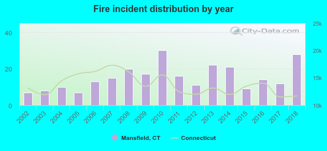 According to the data from the years 2002 - 2018 the average number of fire incidents per year is 15. The highest number of reported fire incidents - 30 took place in 2010, and the least - 7 in 2002. The data has a growing trend.
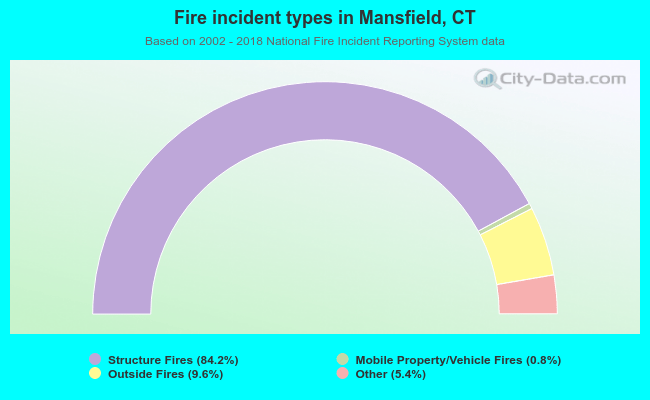 When looking into fire subcategories, the most reports belonged to: Structure Fires (84.2%), and Outside Fires (9.6%).
- 73.7%Fuel oil, kerosene, etc.
- 15.9%Electricity
- 5.3%Bottled, tank, or LP gas
- 2.7%Wood
- 1.1%Coal or coke
- 0.7%Utility gas
- 0.5%Other fuel
- 50.4%Electricity
- 38.5%Fuel oil, kerosene, etc.
- 6.2%Utility gas
- 1.6%Wood
- 1.6%Bottled, tank, or LP gas
- 1.1%Other fuel
- 0.5%No fuel used
Mansfield compared to Connecticut state average:
- Unemployed percentage below state average.
- Hispanic race population percentage below state average.
- Median age significantly below state average.
- Length of stay since moving in significantly above state average.
- Number of rooms per house significantly below state average.
- House age significantly below state average.
- Institutionalized population percentage above state average.
- Number of college students significantly above state average.
- Percentage of population with a bachelor's degree or higher above state average.
Mansfield on our top lists:
- #1 on the list of "Top 101 cities with largest percentage of males in occupations: postsecondary teachers (population 5,000+)"
- #1 on the list of "Top 101 cities with largest percentage of females in occupations: postsecondary teachers (population 5,000+)"
- #12 on the list of "Top 101 cities with largest percentage of females in occupations: life, physical, and social science technicians (population 5,000+)"
- #13 on the list of "Top 101 cities with largest percentage of females in occupations: waiters and waitresses (population 5,000+)"
- #13 on the list of "Top 101 cities with largest percentage of males in occupations: other teachers and instructors, education, training, and library occupations (population 5,000+)"
- #20 on the list of "Top 101 cities with largest percentage of males in industries: book stores and news dealers (population 5,000+)"
- #23 on the list of "Top 101 cities with the most people walking to work (population 5,000+)"
- #26 on the list of "Top 101 cities with largest percentage of females in industries: book stores and news dealers (population 5,000+)"
- #31 on the list of "Top 101 cities with largest percentage of males in industries: educational services (population 5,000+)"
- #33 on the list of "Top 101 cities with largest percentage of males in occupations: life and physical scientists (population 5,000+)"
- #52 on the list of "Top 101 cities with largest percentage of females in industries: data processing, libraries, and other information services (population 5,000+)"
- #54 on the list of "Top 101 cities with the largest percentage of people in college dormitories (includes college quarters off campus) (population 1,000+)"
- #55 on the list of "Top 100 cities with youngest residents (pop. 5,000+)"
- #55 on the list of "Top 101 cities with largest percentage of females in industries: educational services (population 5,000+)"
- #68 on the list of "Top 101 cities with the most people having Master's or Doctorate degrees (population 5,000+)"
- #69 on the list of "Top 101 cities with the most residents born in United Kingdom (population 500+)"
- #69 on the list of "Top 101 cities with the most residents born in Yugoslavia (population 500+)"
- #69 on the list of "Top 101 cities with the most residents born in Asia, n.e.c. (population 500+)"
- #69 on the list of "Top 101 cities with the most residents born in Melanesia (population 500+)"
- #69 on the list of "Top 101 cities with the most residents born in Micronesia (population 500+)"
- #8 on the list of "Top 101 counties with the lowest number of births per 1000 residents 2007-2013"
- #10 on the list of "Top 101 counties with the largest decrease in the number of births per 1000 residents 2000-2006 to 2007-2013 (pop 50,000+)"
- #19 on the list of "Top 101 counties with the best general health status score of residents (1-5), 3 years of data"
- #21 on the list of "Top 101 counties with the highest percentage of residents that visited a dentist within the past year"
- #44 on the list of "Top 101 counties with the highest percentage of residents that exercised in the past month"

|
|
Total of 66 patent applications in 2008-2024.