Mayhaw, Georgia
Submit your own pictures of this place and show them to the world
- OSM Map
- General Map
- Google Map
- MSN Map

| Males: 1,184 | |
| Females: 1,303 |
| Median resident age: | 37.4 years |
| Georgia median age: | 33.4 years |
Zip code: 31737
| Mayhaw: | $60,106 |
| GA: | $72,837 |
Estimated per capita income in 2022: $30,651 (it was $16,009 in 2000)
Mayhaw CCD income, earnings, and wages data
Estimated median house or condo value in 2022: $150,595 (it was $51,100 in 2000)
| Mayhaw: | $150,595 |
| GA: | $297,400 |
Mean prices in 2022: all housing units: $149,944; detached houses: $170,330; mobile homes: $54,763
Detailed information about poverty and poor residents in Mayhaw, GA


- 2,02478.8%White alone
- 52420.4%Black alone
- 80.3%Two or more races
- 50.2%American Indian alone
- 50.2%Native Hawaiian and Other
Pacific Islander alone - 40.2%Hispanic

Races in Mayhaw detailed stats: ancestries, foreign born residents, place of birth
 Recent articles from our blog. Our writers, many of them Ph.D. graduates or candidates, create easy-to-read articles on a wide variety of topics.

Current Local Time: EST time zone
Elevation: 191 feet
Land area: 131.6 square miles.
Population density: 19 people per square mile (very low).

| Mayhaw CCD: | 1.1% ($545) |
| Georgia: | 0.9% ($919) |
Nearest city with pop. 50,000+: Dothan, AL  (36.5 miles , pop. 57,737).
Nearest city with pop. 200,000+: Montgomery, AL (121.0 miles , pop. 201,568).
Nearest city with pop. 1,000,000+: Houston, TX (638.1 miles , pop. 1,953,631).
Nearest cities:
), ), )Latitude: 31.15 N, Longitude: 84.80 W
Area code commonly used in this area: 229


| Here: | 2.2% |
| Georgia: | 2.9% |

- Health care (10.6%)
- Agriculture, forestry, fishing & hunting (8.4%)
- Educational services (7.4%)
- Food & beverage stores (5.7%)
- Construction (5.0%)
- Professional, scientific, technical services (5.0%)
- Public administration (4.8%)

- Agriculture, forestry, fishing & hunting (16.0%)
- Construction (9.5%)
- Truck transportation (6.3%)
- Food & beverage stores (6.1%)
- Health care (6.1%)
- Paper (5.6%)
- Food (5.3%)

- Health care (15.6%)
- Educational services (13.1%)
- Apparel (9.2%)
- Professional, scientific, technical services (7.7%)
- Food & beverage stores (5.2%)
- Finance & insurance (4.9%)
- Public administration (4.7%)

- Other production occupations, including supervisors (7.5%)
- Other management occupations, except farmers and farm managers (5.8%)
- Driver/sales workers and truck drivers (5.3%)
- Farmers and farm managers (5.1%)
- Retail sales workers, except cashiers (4.6%)
- Other sales and related occupations, including supervisors (4.5%)
- Material recording, scheduling, dispatching, and distributing workers (4.3%)

- Driver/sales workers and truck drivers (10.1%)
- Farmers and farm managers (9.8%)
- Other production occupations, including supervisors (9.8%)
- Other management occupations, except farmers and farm managers (8.1%)
- Laborers and material movers, hand (6.3%)
- Material recording, scheduling, dispatching, and distributing workers (6.0%)
- Vehicle and mobile equipment mechanics, installers, and repairers (5.0%)

- Textile, apparel, and furnishings workers (8.6%)
- Secretaries and administrative assistants (8.6%)
- Other sales and related occupations, including supervisors (7.4%)
- Retail sales workers, except cashiers (5.2%)
- Other production occupations, including supervisors (5.0%)
- Information and record clerks, except customer service representatives (4.9%)
- Preschool, kindergarten, elementary, and middle school teachers (4.0%)
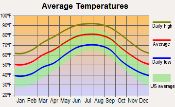
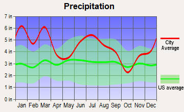
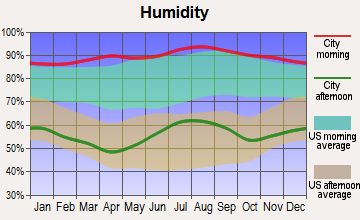
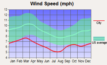
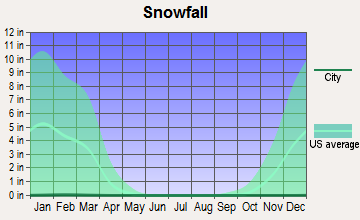
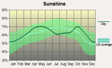
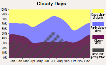
Average climate in Mayhaw, Georgia
Based on data reported by over 4,000 weather stations
Tornado activity:
Mayhaw-area historical tornado activity is slightly above Georgia state average. It is 48% greater than the overall U.S. average.
On 3/22/2005, a category F3 (max. wind speeds 158-206 mph) tornado 9.8 miles away from the Mayhaw place center killed one person and injured 18 people and caused $7 million in damages.
On 12/28/1968, a category F3 tornado 29.2 miles away from the place center caused between $5000 and $50,000 in damages.
Earthquake activity:
Mayhaw-area historical earthquake activity is significantly above Georgia state average. It is 8% smaller than the overall U.S. average.On 10/24/1997 at 08:35:17, a magnitude 4.9 (4.8 MB, 4.2 MS, 4.9 LG, Depth: 6.2 mi, Class: Light, Intensity: IV - V) earthquake occurred 146.5 miles away from Mayhaw center
On 1/18/1999 at 07:00:53, a magnitude 4.8 (4.8 MB, 4.0 LG, Depth: 0.6 mi) earthquake occurred 212.2 miles away from Mayhaw center
On 8/2/1974 at 08:52:09, a magnitude 4.9 (4.3 MB, 4.9 LG) earthquake occurred 231.7 miles away from the city center
On 4/29/2003 at 08:59:39, a magnitude 4.9 (4.4 MB, 4.6 MW, 4.9 LG) earthquake occurred 236.5 miles away from the city center
On 4/29/2003 at 08:59:39, a magnitude 4.6 (4.6 MW, Depth: 12.3 mi) earthquake occurred 236.5 miles away from the city center
On 11/7/2004 at 11:20:21, a magnitude 4.3 (4.3 MW, Depth: 3.1 mi) earthquake occurred 211.4 miles away from Mayhaw center
Magnitude types: regional Lg-wave magnitude (LG), body-wave magnitude (MB), surface-wave magnitude (MS), moment magnitude (MW)
Natural disasters:
The number of natural disasters in Miller County (8) is smaller than the US average (15).Major Disasters (Presidential) Declared: 5
Emergencies Declared: 2
Causes of natural disasters: Floods: 3, Hurricanes: 3, Tornadoes: 3, Storms: 2, Drought: 1, Heavy Rain: 1, Tropical Storm: 1, Wind: 1, Other: 1 (Note: some incidents may be assigned to more than one category).
Hospitals and medical centers near Mayhaw:
- MILLER NURSING HOME (Nursing Home, about 5 miles away; COLQUITT, GA)
- MILLER COUNTY HOSPITAL Critical Access Hospitals (about 5 miles away; COLQUITT, GA)
- SEMINOLE MANOR NH (Nursing Home, about 9 miles away; DONALSONVILLE, GA)
- SEMINOLE MANOR NURSING HOME (Nursing Home, about 9 miles away; DONALSONVILLE, GA)
Colleges/universities with over 2000 students nearest to Mayhaw:
- Bainbridge State College (about 24 miles; Bainbridge, GA; Full-time enrollment: 2,308)
- George C Wallace State Community College-Dothan (about 42 miles; Dothan, AL; FT enrollment: 3,611)
- Darton State College (about 46 miles; Albany, GA; FT enrollment: 5,000)
- Albany Technical College (about 47 miles; Albany, GA; FT enrollment: 3,707)
- Albany State University (about 49 miles; Albany, GA; FT enrollment: 3,662)
- Tallahassee Community College (about 56 miles; Tallahassee, FL; FT enrollment: 10,904)
- Florida State University (about 58 miles; Tallahassee, FL; FT enrollment: 38,283)
Points of interest:
Notable location: Miller County Volunteer Fire Department Station 3 - Enterprize Volunteer Fire Department (A). Display/hide its location on the map
Churches in Mayhaw include: Evergreen Church (A), Boykin Church of God (B), Hopewell Church (C), Church of Christ (D), Morning Star Church (E), Mothers Home Church (F), New Home Church (G), New Salem Church (H), Pilgrims Rest Church (I). Display/hide their locations on the map
Cemeteries: Lane Cemetery (1), Boykin Cemetery (2), Colquitt City Cemetery (3), Flat Creek Cemetery (4), Mothers Home Cemetery (5), New Home Cemetery (6), New Salem Cemetery (7). Display/hide their locations on the map
Lakes and swamps: Gilbert Lake (A), Byrd Pond (B), Full Ford Pond (C), Piney Pond (D). Display/hide their locations on the map
Streams, rivers, and creeks: Aycocks Creek (A), Kaney Head Creek (B), Susian Ford Creek (C), Sow Branch (D), Flat Creek (E), Dry Creek (F), Cypress Creek (G), Big Drain (H), Acocks Creek (I). Display/hide their locations on the map
Park in Mayhaw: Miller County Wildlife Management Area (1). Display/hide its location on the map
| This place: | 2.5 people |
| Georgia: | 2.6 people |
| This place: | 70.5% |
| Whole state: | 68.5% |
| This place: | 4.6% |
| Whole state: | 5.9% |
Likely homosexual households (counted as self-reported same-sex unmarried-partner households)
- Lesbian couples: 0.1% of all households
- Gay men: 0.0% of all households
| This place: | 19.5% |
| Whole state: | 13.0% |
| This place: | 3.9% |
| Whole state: | 6.1% |
For population 15 years and over in Mayhaw:

- Never married: 21.7%
- Now married: 58.2%
- Separated: 3.5%
- Widowed: 7.0%
- Divorced: 13.1%
For population 25 years and over in Mayhaw:
- High school or higher: 74.5%
- Bachelor's degree or higher: 11.6%
- Graduate or professional degree: 5.1%
- Unemployed: 3.5%
- Mean travel time to work (commute): 17.7 minutes


| Here: | 12.9 |
| Georgia average: | 13.3 |


Graphs represent county-level data. Detailed 2008 Election Results
Religion statistics for Mayhaw, GA (based on Miller County data)
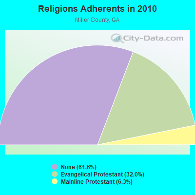
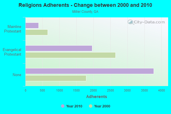
| Religion | Adherents | Congregations |
|---|---|---|
| Evangelical Protestant | 1,960 | 17 |
| Mainline Protestant | 387 | 2 |
| Other | 3 | - |
| None | 3,775 | - |
Food Environment Statistics:
| Miller County: | 9.75 / 10,000 pop. |
| Georgia: | 1.91 / 10,000 pop. |
| Here: | 3.25 / 10,000 pop. |
| State: | 0.86 / 10,000 pop. |
| This county: | 6.50 / 10,000 pop. |
| State: | 5.12 / 10,000 pop. |
| Miller County: | 4.87 / 10,000 pop. |
| State: | 7.41 / 10,000 pop. |
| Here: | 13.6% |
| Georgia: | 10.4% |
| This county: | 29.9% |
| State: | 27.8% |
| Here: | 13.2% |
| Georgia: | 14.6% |
Strongest AM radio stations in Mayhaw:
- WSEM (1500 AM; daytime; 1 kW; DONALSONVILLE, GA; Owner: SEMINOLE BROADCASTING CO.)
- WSTT (730 AM; 25 kW; THOMASVILLE, GA; Owner: MARION R. WILLIAMS)
- WMGR (930 AM; 5 kW; BAINBRIDGE, GA; Owner: DECATUR BROADCASTING, INC.)
- WOOF (560 AM; 5 kW; DOTHAN, AL; Owner: WOOF, INC.)
- WTCL (1580 AM; daytime; 10 kW; CHATTAHOOCHEE, FL; Owner: METZ, INC.)
- WJEP (1020 AM; daytime; 10 kW; OCHLOCKNEE, GA; Owner: LIFELINE MINISTRIES, INCORPORATED)
- WHGH (840 AM; daytime; 10 kW; THOMASVILLE, GA; Owner: H. G. H INVESTMENT CORP.)
- WFVR (910 AM; 50 kW; VALDOSTA, GA; Owner: RAMA COMMUNICATIONS, INC.)
- WMAC (940 AM; 50 kW; MACON, GA; Owner: CUMULUS LICENSING CORP.)
- WFRF (1070 AM; daytime; 10 kW; TALLAHASSEE, FL; Owner: FAITH RADIO NETWORK, INC.)
- WQLS (1200 AM; 10 kW; OZARK, AL; Owner: STYLES BROADCASTING OF DOTHAN, INC.)
- WMGA (1130 AM; 10 kW; MOULTRIE, GA; Owner: RADIO MOULTRIE, INC.)
- WBBK (1260 AM; daytime; 1 kW; BLAKELY, GA; Owner: MERCHANTS BROADCASTING SYSTEMS)
Strongest FM radio stations in Mayhaw:
- WRAK-FM (97.3 FM; BAINBRIDGE, GA; Owner: CLEAR CHANNEL BROADCASTING LICENSES, INC.)
- WGMK (106.3 FM; DONALSONVILLE, GA; Owner: MERCHANTS BROADCASTING CO)
- WTVY-FM (95.5 FM; DOTHAN, AL; Owner: STYLES BROADCASTING OF DOTHAN, INC.)
- WBBK-FM (93.1 FM; BLAKELY, GA; Owner: MERCHANTS BROADCASTING SYSTEMS OF SW GA)
- WOOF-FM (99.7 FM; DOTHAN, AL; Owner: WOOF, INC.)
- WZND (105.3 FM; HEADLAND, AL; Owner: GULF SOUTH COMMUNICATIONS, INC.)
- WWGF (107.5 FM; DONALSONVILLE, GA; Owner: BARINOWSKI INVESTMENT COMPANY)
- WJJN (92.1 FM; COLUMBIA, AL; Owner: WILSON BROADCASTING CO., INC.)
- WBGE (101.9 FM; BAINBRIDGE, GA; Owner: JOHN H. WIGGINS)
- WAGF-FM (101.3 FM; DOTHAN, AL; Owner: WILSON BROADCASTING CO., INC.)
TV broadcast stations around Mayhaw:
- W69DO (Channel 69; COLQUITT, GA; Owner: MS COMMUNICATIONS, LLC)
- W26BM (Channel 26; COLQUITT, GA; Owner: MS COMMUNICATIONS, LLC)
- W45BL (Channel 45; COLQUITT, GA; Owner: MS COMMUNICATIONS, LLC)
- W51CQ (Channel 51; COLQUITT, GA; Owner: MS COMMUNICATIONS, LLC)
- W08DM (Channel 8; COLQUITT, GA; Owner: MS COMMUNICATIONS, LLC)
- W30BO (Channel 30; COLQUITT, GA; Owner: MS COMMUNICATIONS, LLC)
- WTLH (Channel 49; BAINBRIDGE, GA; Owner: WTLH LICENSE CORP.)
- W47BX (Channel 47; COLQUITT, GA; Owner: MS COMMUNICATIONS, LLC)
- WABW-TV (Channel 14; PELHAM, GA; Owner: GEORGIA PUBLIC TELECOMMUNICATIONS COMMISSION)
- WTWC-TV (Channel 40; TALLAHASSEE, FL; Owner: WTWC LICENSEE, LLC)
- WTXL-TV (Channel 27; TALLAHASSEE, FL; Owner: MEDIA VENTURE MANAGEMENT, INC.)
- WTVY (Channel 4; DOTHAN, AL; Owner: GRAY MIDAMERICA TV LICENSEE CORP.)
- WCTV (Channel 6; THOMASVILLE, GA; Owner: WCTV LICENSEE CORP.)
- WDHN (Channel 18; DOTHAN, AL; Owner: MORRIS NETWORK OF ALABAMA, INC.)
- W22BV (Channel 22; COLQUITT, GA; Owner: MS COMMUNICATIONS, LLC)

- 73.4%Electricity
- 20.3%Bottled, tank, or LP gas
- 2.4%No fuel used
- 1.7%Wood
- 1.4%Utility gas
- 0.7%Fuel oil, kerosene, etc.

- 58.1%Electricity
- 39.6%Bottled, tank, or LP gas
- 2.3%Utility gas
Mayhaw compared to Georgia state average:
- Median house value below state average.
- Unemployed percentage significantly below state average.
- Hispanic race population percentage significantly below state average.
- Foreign-born population percentage significantly below state average.
- Length of stay since moving in significantly above state average.
- Number of rooms per house significantly below state average.
- House age significantly below state average.
- Percentage of population with a bachelor's degree or higher below state average.