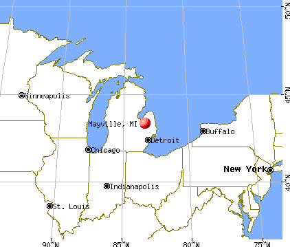
Mayville, Michigan
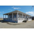
Mayville: Depot at Mayville, located on M24 south of town
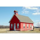
Mayville: Old schoolhouse at the Mayville Museum
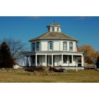
Mayville: MayAville Octagon House
- add
your


Submit your own pictures of this village and show them to the world
- OSM Map
- General Map
- Google Map
- MSN Map

Population change since 2000: -13.6%
 |
| Males: 461 | |
| Females: 450 |
| Median resident age: | 41.8 years |
| Michigan median age: | 40.3 years |
Zip codes: 48744.
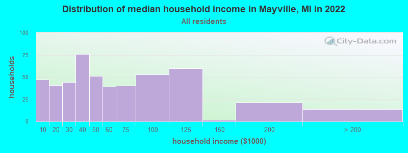
| Mayville: | $43,866 |
| MI: | $66,986 |
Estimated per capita income in 2022: $26,028 (it was $15,281 in 2000)
Mayville village income, earnings, and wages data
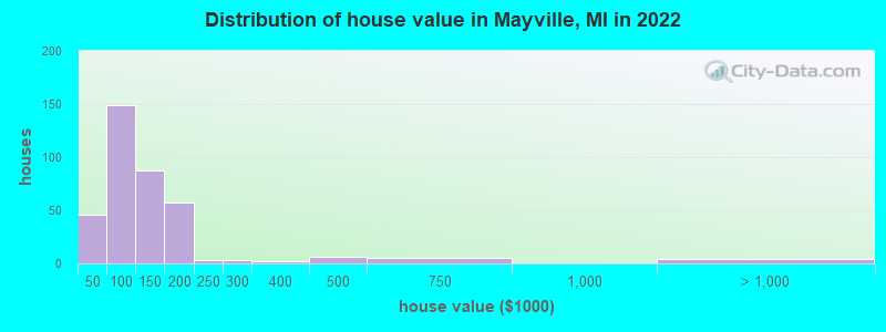
Estimated median house or condo value in 2022: $108,016 (it was $80,100 in 2000)
| Mayville: | $108,016 |
| MI: | $224,400 |
Median gross rent in 2022: $748.
(20.0% for White Non-Hispanic residents, 6.2% for two or more races residents)
Detailed information about poverty and poor residents in Mayville, MI
Compare current foreclosures near Mayville, MI:
| Photo | Address | Area | Beds / Baths | Price | Details |
|---|---|---|---|---|---|

|
#1
Trend St # C
Mayville, MI 48744
|
- sq. feet
|
- baths - beds |
show details | |

|
#2
W Main St
Mayville, MI 48744
|
- sq. feet
|
- baths - beds |
show details | |

|
#3
Mertz Rd
Mayville, MI 48744
|
- sq. feet
|
- baths - beds |
show details | |

|
#4
Ambrose Rd
Mayville, MI 48744
|
- sq. feet
|
- baths - beds |
show details | |

|
#5
Fulton St
Mayville, MI 48744
|
- sq. feet
|
- baths - beds |
show details | |

|
#6
2nd St
Mayville, MI 48744
|
- sq. feet
|
- baths - beds |
show details | |

|
#7
2nd St
Mayville, MI 48744
|
- sq. feet
|
- baths - beds |
show details | |

|
#8
Lynch Dr
Mayville, MI 48744
|
- sq. feet
|
- baths - beds |
show details | |

|
#9
Kirk Rd
Vassar, MI 48768
|
1,700 sq. feet
|
2 baths 3 beds |
show details | |

|
#10
Pinkerton Rd
Vassar, MI 48768
|
1,200 sq. feet
|
1 baths 3 beds |
show details |
| Photo | Address | Area | Beds / Baths | Price | Details |
|---|---|---|---|---|---|

|
#11
Central St
Columbiaville, MI 48421
|
1,729 sq. feet
|
2 baths 5 beds |
show details | |

|
#12
Otter Lake Rd
Otter Lake, MI 48464
|
1,036 sq. feet
|
1 baths 3 beds |
show details | |

|
#13
Mckillop Rd
Clifford, MI 48727
|
1,404 sq. feet
|
2 baths 3 beds |
show details | |

|
#14
Maple Dr
Columbiaville, MI 48421
|
- sq. feet
|
2 baths 3 beds |
show details | |

|
#15
White Creek Rd
Kingston, MI 48741
|
- sq. feet
|
- baths - beds |
show details | |

|
#16
N Main St
Vassar, MI 48768
|
- sq. feet
|
- baths - beds |
show details | |

|
#17
Woodvalley Dr # 142
Millington, MI 48746
|
- sq. feet
|
- baths - beds |
show details | |

|
#18
E Deckerville Rd Apt 302
Caro, MI 48723
|
- sq. feet
|
- baths - beds |
show details | |

|
#19
Colwood Rd
Caro, MI 48723
|
- sq. feet
|
- baths - beds |
show details | |

|
#20
Cedar Creek Rd
North Branch, MI 48461
|
- sq. feet
|
- baths - beds |
show details |
| Photo | Address | Area | Beds / Baths | Price | Details |
|---|---|---|---|---|---|

|
#21
Central St # B
Columbiaville, MI 48421
|
- sq. feet
|
- baths - beds |
show details | |

|
#22
Rupprecht Rd
Vassar, MI 48768
|
- sq. feet
|
- baths - beds |
show details | |

|
#23
Belsay Rd
Millington, MI 48746
|
- sq. feet
|
- baths - beds |
show details | |

|
#24
Bradleyville Rd Apt 1
Vassar, MI 48768
|
- sq. feet
|
- baths - beds |
show details | |

|
#25
E Main St
Otisville, MI 48463
|
- sq. feet
|
- baths - beds |
show details | |

|
#26
Bittersweet Dr
Columbiaville, MI 48421
|
- sq. feet
|
- baths - beds |
show details | |

|
#27
Willis Rd
North Branch, MI 48461
|
- sq. feet
|
- baths - beds |
show details | |

|
#28
E Deckerville Rd
Deford, MI 48729
|
- sq. feet
|
- baths - beds |
show details | |

|
#29
Evelyn Dr
Clio, MI 48420
|
- sq. feet
|
- baths - beds |
show details | |

|
#30
W Gamble St
Caro, MI 48723
|
- sq. feet
|
- baths - beds |
show details |
| Photo | Address | Area | Beds / Baths | Price | Details |
|---|---|---|---|---|---|

|
#31
Caro Rd
Vassar, MI 48768
|
- sq. feet
|
- baths - beds |
show details | |

|
#32
Gray Rd
Lapeer, MI 48446
|
- sq. feet
|
- baths - beds |
show details | |

|
#33
Birch Ln
Vassar, MI 48768
|
- sq. feet
|
- baths - beds |
show details | |

|
#34
Snover Rd
Silverwood, MI 48760
|
- sq. feet
|
- baths - beds |
show details | |

|
#35
Fostoria Rd
Fostoria, MI 48435
|
- sq. feet
|
- baths - beds |
show details | |

|
#36
W Castle Rd
Fostoria, MI 48435
|
- sq. feet
|
- baths - beds |
show details | |

|
#37
Vassar Rd
Millington, MI 48746
|
- sq. feet
|
- baths - beds |
show details | |

|
#38
Snoblin Rd
North Branch, MI 48461
|
- sq. feet
|
- baths - beds |
show details | |

|
#39
Harris Rd
Millington, MI 48746
|
- sq. feet
|
- baths - beds |
show details | |

|
#40
S Van Dyke Rd
Marlette, MI 48453
|
- sq. feet
|
- baths - beds |
show details |
| Photo | Address | Area | Beds / Baths | Price | Details |
|---|---|---|---|---|---|

|
#41
Willard Rd
Millington, MI 48746
|
- sq. feet
|
- baths - beds |
show details | |

|
#42
Pine Lake Trl
Marlette, MI 48453
|
- sq. feet
|
- baths - beds |
show details | |

|
#43
Ellsworth St
Marlette, MI 48453
|
- sq. feet
|
- baths - beds |
show details | |

|
#44
Prospect St
Marlette, MI 48453
|
- sq. feet
|
- baths - beds |
show details | |

|
#45
Chard St
Marlette, MI 48453
|
- sq. feet
|
- baths - beds |
show details | |

|
#46
E Main St
Otisville, MI 48463
|
- sq. feet
|
- baths - beds |
show details | |

|
#47
French Rd
Caro, MI 48723
|
- sq. feet
|
- baths - beds |
show details | |

|
#48
Cedar Creek Rd
North Branch, MI 48461
|
- sq. feet
|
- baths - beds |
show details | |

|
#49
Jefferson Rd
North Branch, MI 48461
|
- sq. feet
|
- baths - beds |
show details | |

|
Check over 1 million property listings on Foreclosure.com!
|
browse all offers | |||


- 1,06991.8%White alone
- 474.0%Hispanic
- 191.6%Two or more races
- 161.4%Black alone
- 40.3%Other race alone
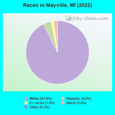
Races in Mayville detailed stats: ancestries, foreign born residents, place of birth
According to our research of Michigan and other state lists, there were 23 registered sex offenders living in Mayville, Michigan as of April 25, 2024.
The ratio of all residents to sex offenders in Mayville is 41 to 1.
Type |
2009 |
2010 |
2011 |
2012 |
2013 |
2014 |
2015 |
2016 |
2017 |
2018 |
2019 |
2020 |
2021 |
2022 |
|---|---|---|---|---|---|---|---|---|---|---|---|---|---|---|
| Murders (per 100,000) | 0 (0.0) | 0 (0.0) | 0 (0.0) | 0 (0.0) | 0 (0.0) | 0 (0.0) | 0 (0.0) | 0 (0.0) | 0 (0.0) | 0 (0.0) | 0 (0.0) | 0 (0.0) | 0 (0.0) | 0 (0.0) |
| Rapes (per 100,000) | 0 (0.0) | 0 (0.0) | 0 (0.0) | 0 (0.0) | 0 (0.0) | 0 (0.0) | 1 (108.8) | 2 (218.8) | 1 (110.5) | 0 (0.0) | 4 (453.5) | 0 (0.0) | 1 (113.9) | 0 (0.0) |
| Robberies (per 100,000) | 0 (0.0) | 0 (0.0) | 0 (0.0) | 0 (0.0) | 0 (0.0) | 0 (0.0) | 0 (0.0) | 0 (0.0) | 0 (0.0) | 0 (0.0) | 0 (0.0) | 0 (0.0) | 0 (0.0) | 0 (0.0) |
| Assaults (per 100,000) | 1 (101.9) | 2 (210.5) | 0 (0.0) | 0 (0.0) | 1 (107.8) | 0 (0.0) | 0 (0.0) | 3 (328.2) | 3 (331.5) | 1 (112.6) | 0 (0.0) | 0 (0.0) | 1 (113.9) | 1 (110.0) |
| Burglaries (per 100,000) | 5 (509.7) | 1 (105.3) | 4 (421.5) | 2 (211.6) | 3 (323.3) | 0 (0.0) | 1 (108.8) | 2 (218.8) | 0 (0.0) | 0 (0.0) | 0 (0.0) | 1 (113.9) | 1 (113.9) | 0 (0.0) |
| Thefts (per 100,000) | 16 (1,631) | 52 (5,474) | 17 (1,791) | 10 (1,058) | 14 (1,509) | 9 (973.0) | 4 (435.3) | 5 (547.0) | 11 (1,215) | 7 (788.3) | 3 (340.1) | 4 (455.6) | 6 (683.4) | 0 (0.0) |
| Auto thefts (per 100,000) | 0 (0.0) | 0 (0.0) | 0 (0.0) | 0 (0.0) | 0 (0.0) | 0 (0.0) | 1 (108.8) | 1 (109.4) | 0 (0.0) | 0 (0.0) | 0 (0.0) | 0 (0.0) | 0 (0.0) | 0 (0.0) |
| Arson (per 100,000) | 0 (0.0) | 3 (315.8) | 0 (0.0) | 0 (0.0) | 0 (0.0) | 0 (0.0) | 0 (0.0) | 1 (109.4) | 0 (0.0) | 0 (0.0) | 0 (0.0) | 0 (0.0) | 0 (0.0) | 0 (0.0) |
| City-Data.com crime index | 121.3 | 268.4 | 101.2 | 57.1 | 104.5 | 38.9 | 120.8 | 286.7 | 203.3 | 54.1 | 376.4 | 26.2 | 149.2 | 22.0 |
The City-Data.com crime index weighs serious crimes and violent crimes more heavily. Higher means more crime, U.S. average is 246.1. It adjusts for the number of visitors and daily workers commuting into cities.
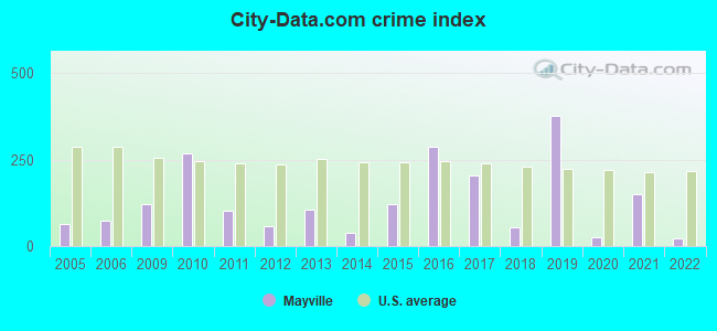
Crime rate in Mayville detailed stats: murders, rapes, robberies, assaults, burglaries, thefts, arson
Full-time law enforcement employees in 2021, including police officers: 3 (3 officers - 2 male; 1 female).
| Officers per 1,000 residents here: | 3.42 |
| Michigan average: | 1.86 |
 Recent articles from our blog. Our writers, many of them Ph.D. graduates or candidates, create easy-to-read articles on a wide variety of topics.


 | Need to leave quietly & swiftly... (12 replies) |
| Are there any towns like this? (28 replies) |
| Want to move (11 replies) |
Latest news from Mayville, MI collected exclusively by city-data.com from local newspapers, TV, and radio stations
Ancestries: German (28.1%), English (12.7%), Irish (10.7%), Scottish (7.8%), American (5.4%), European (4.9%).
Current Local Time: EST time zone
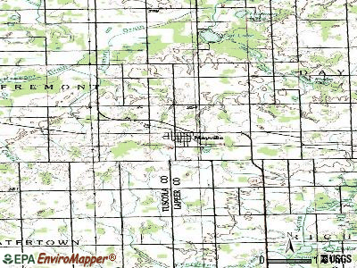
Elevation: 910 feet
Land area: 1.03 square miles.
Population density: 888 people per square mile (low).
11 residents are foreign born
| This village: | 0.9% |
| Michigan: | 6.9% |
Median real estate property taxes paid for housing units with mortgages in 2022: $1,608 (1.5%)
Median real estate property taxes paid for housing units with no mortgage in 2022: $1,414 (1.4%)
Nearest city with pop. 50,000+: Flint, MI  (27.5 miles , pop. 124,943).
Nearest city with pop. 200,000+: Detroit, MI (66.8 miles , pop. 951,270).
Nearest city with pop. 1,000,000+: Chicago, IL (243.4 miles , pop. 2,896,016).
Nearest cities:
), ), ), ), ), Latitude: 43.34 N, Longitude: 83.35 W
Area code: 989
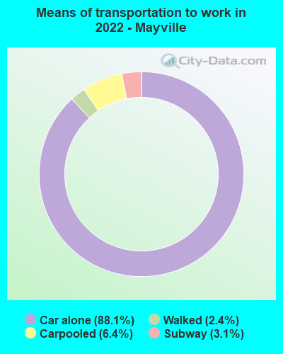
| Here: | 4.7% |
| Michigan: | 3.5% |
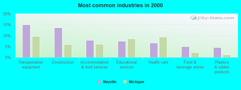
- Transportation equipment (15.1%)
- Construction (13.6%)
- Accommodation & food services (7.8%)
- Educational services (7.4%)
- Health care (6.6%)
- Food & beverage stores (4.9%)
- Plastics & rubber products (4.5%)
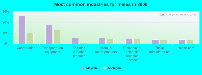
- Construction (25.8%)
- Transportation equipment (17.7%)
- Plastics & rubber products (5.2%)
- Metal & metal products (5.2%)
- Professional, scientific, technical services (4.4%)
- Public administration (4.0%)
- Health care (4.0%)
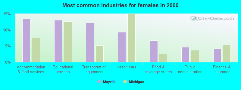
- Accommodation & food services (13.5%)
- Educational services (13.1%)
- Transportation equipment (12.2%)
- Health care (9.3%)
- Food & beverage stores (6.8%)
- Public administration (4.6%)
- Finance & insurance (4.2%)
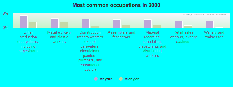
- Other production occupations, including supervisors (6.8%)
- Metal workers and plastic workers (5.2%)
- Construction traders workers except carpenters, electricians, painters, plumbers, and construction laborers (4.9%)
- Assemblers and fabricators (4.5%)
- Material recording, scheduling, dispatching, and distributing workers (4.5%)
- Retail sales workers, except cashiers (3.9%)
- Waiters and waitresses (3.9%)

- Construction traders workers except carpenters, electricians, painters, plumbers, and construction laborers (9.7%)
- Metal workers and plastic workers (8.1%)
- Other production occupations, including supervisors (6.9%)
- Carpenters (6.5%)
- Driver/sales workers and truck drivers (5.2%)
- Material recording, scheduling, dispatching, and distributing workers (4.8%)
- Assemblers and fabricators (4.0%)
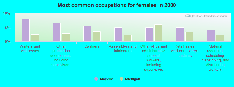
- Waiters and waitresses (8.0%)
- Other production occupations, including supervisors (6.8%)
- Cashiers (5.5%)
- Assemblers and fabricators (5.1%)
- Other office and administrative support workers, including supervisors (5.1%)
- Retail sales workers, except cashiers (5.1%)
- Material recording, scheduling, dispatching, and distributing workers (4.2%)
Average climate in Mayville, Michigan
Based on data reported by over 4,000 weather stations


|
|

(lower is better)
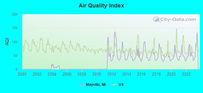
Air Quality Index (AQI) level in 2023 was 74.6. This is about average.
| City: | 74.6 |
| U.S.: | 72.6 |
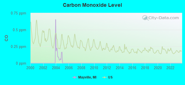
Carbon Monoxide (CO) [ppm] level in 2004 was 0.117. This is significantly better than average. Closest monitor was 12.9 miles away from the city center.
| City: | 0.117 |
| U.S.: | 0.251 |
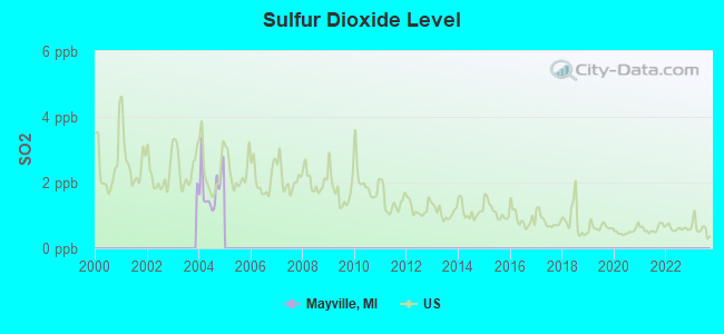
Sulfur Dioxide (SO2) [ppb] level in 2004 was 1.85. This is worse than average. Closest monitor was 10.6 miles away from the city center.
| City: | 1.85 |
| U.S.: | 1.51 |
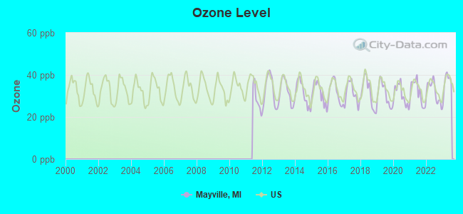
Ozone [ppb] level in 2023 was 36.4. This is about average. Closest monitor was 19.2 miles away from the city center.
| City: | 36.4 |
| U.S.: | 33.3 |
Tornado activity:
Mayville-area historical tornado activity is slightly above Michigan state average. It is 11% greater than the overall U.S. average.
On 6/8/1953, a category F5 (max. wind speeds 261-318 mph) tornado 12.0 miles away from the Mayville village center killed 116 people and injured 844 people and caused between $5,000,000 and $50,000,000 in damages.
On 6/8/1953, a category F4 (max. wind speeds 207-260 mph) tornado 15.5 miles away from the village center injured 23 people and caused between $50,000 and $500,000 in damages.
Earthquake activity:
Mayville-area historical earthquake activity is significantly above Michigan state average. It is 56% smaller than the overall U.S. average.On 9/25/1998 at 19:52:52, a magnitude 5.2 (4.8 MB, 4.3 MS, 5.2 LG, 4.5 MW, Depth: 3.1 mi, Class: Moderate, Intensity: VI - VII) earthquake occurred 197.6 miles away from Mayville center
On 1/31/1986 at 16:46:43, a magnitude 5.0 (5.0 MB) earthquake occurred 163.9 miles away from Mayville center
On 5/2/2015 at 16:23:07, a magnitude 4.2 (4.2 MW, Depth: 2.8 mi, Class: Light, Intensity: IV - V) earthquake occurred 130.1 miles away from the city center
On 7/12/1986 at 08:19:37, a magnitude 4.5 (4.5 MB) earthquake occurred 200.6 miles away from Mayville center
On 7/27/1980 at 18:52:21, a magnitude 5.2 (5.1 MB, 4.7 MS, 5.0 UK, 5.2 UK) earthquake occurred 356.3 miles away from Mayville center
On 6/10/2019 at 14:50:45, a magnitude 4.0 (4.0 MB, Depth: 1.2 mi) earthquake occurred 149.8 miles away from the city center
Magnitude types: regional Lg-wave magnitude (LG), body-wave magnitude (MB), surface-wave magnitude (MS), moment magnitude (MW)
Natural disasters:
The number of natural disasters in Tuscola County (10) is smaller than the US average (15).Major Disasters (Presidential) Declared: 6
Emergencies Declared: 3
Causes of natural disasters: Floods: 6, Storms: 5, Blizzard: 1, Hurricane: 1, Snowstorm: 1, Tornado: 1, Winter Storm: 1, Other: 1 (Note: some incidents may be assigned to more than one category).
Hospitals and medical centers in Mayville:
Other hospitals and medical centers near Mayville:
- CARO CENTER (Hospital, about 9 miles away; CARO, MI)
- HEARTLAND HOME HEALTHCARE (Home Health Center, about 10 miles away; CARO, MI)
- CARO COMMUNITY HOSPITAL Critical Access Hospitals (about 12 miles away; CARO, MI)
- FMC - CARO DIALYSIS (Dialysis Facility, about 12 miles away; CARO, MI)
- TUSCOLA COUNTY MEDICAL CARE FACILITY (Nursing Home, about 12 miles away; CARO, MI)
- MARLETTE COMMUNITY HOSPITAL (Hospital, about 14 miles away; MARLETTE, MI)
- MARLETTE COMM HOSP LTCU (Nursing Home, about 14 miles away; MARLETTE, MI)
Colleges/universities with over 2000 students nearest to Mayville:
- Mott Community College (about 28 miles; Flint, MI; Full-time enrollment: 7,394)
- University of Michigan-Flint (about 28 miles; Flint, MI; FT enrollment: 6,284)
- Kettering University (about 29 miles; Flint, MI; FT enrollment: 2,044)
- Baker College Center for Graduate Studies (about 31 miles; Flint, MI; FT enrollment: 3,405)
- Baker College of Flint (about 31 miles; Flint, MI; FT enrollment: 3,877)
- Saginaw Valley State University (about 35 miles; University Center, MI; FT enrollment: 9,021)
- Delta College (about 36 miles; University Center, MI; FT enrollment: 7,480)
Public high schools in Mayville:
- MAYVILLE HIGH SCHOOL (Students: 349, Location: 6250 FULTON ST, Grades: 9-12)
- MAYVILLE MIDDLE SCHOOL (Students: 226, Location: 6210 FULTON ST, Grades: 6-12)
Public elementary/middle school in Mayville:
- MAYVILLE ELEMENTARY SCHOOL (Students: 413, Location: 106 ORCHARD ST, Grades: KG-6)
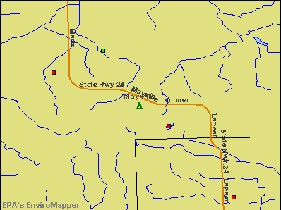
Points of interest:
Notable locations in Mayville: Mayville Station (A), Mayville Area Ambulance Service (B), Mayville District Public Library (C), Mayville Village Police Department (D), Mayville Fire Department (E). Display/hide their locations on the map
Churches in Mayville include: Saint Joseph Church (A), Mayville United Methodist Church (B), Saint Paul Lutheran Church (C), Mills Memorial Baptist Church (D), Spring of Life Community Church (E). Display/hide their locations on the map
Drinking water stations with addresses in Mayville and their reported violations in the past:
KINGSWOOD OUTFIELD (Population served: 94, Groundwater):Past monitoring violations:MAYVILLE GOLDEN YEARS CLUB (Population served: 50, Groundwater):
- 4 routine major monitoring violations
Past monitoring violations:
- One routine major monitoring violation
- 2 regular monitoring violations
Drinking water stations with addresses in Mayville that have no violations reported:
- SUNRISE SUNSET BAR (Population served: 135, Primary Water Source Type: Groundwater)
- THE FOWLER CTR WELL#1 ACTVTY B (Population served: 130, Primary Water Source Type: Groundwater)
- PLEASANT VIEW FREE METHODIST (Population served: 100, Primary Water Source Type: Groundwater)
- THE FOWLER CTR WLL#2-TRLR/CBNS (Population served: 40, Primary Water Source Type: Groundwater)
| This village: | 2.4 people |
| Michigan: | 2.5 people |
| This village: | 63.7% |
| Whole state: | 66.0% |
| This village: | 6.8% |
| Whole state: | 6.4% |
Likely homosexual households (counted as self-reported same-sex unmarried-partner households)
- Lesbian couples: 0.3% of all households
- Gay men: 0.3% of all households
2 people in workers' group living quarters and job corps centers in 2010
Banks with branches in Mayville (2011 data):
- Mayville State Bank: at 6104 Fulton, branch established on 1885/04/15; Main Street Supermarket Branch at 315 East Main Street, branch established on 1997/07/10. Info updated 2006/11/03: Bank assets: $89.1 mil, Deposits: $79.7 mil, local headquarters, positive income, 3 total offices, Holding Company: Mayville Financial Corporation
For population 15 years and over in Mayville:
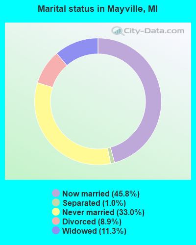
- Never married: 33.0%
- Now married: 45.8%
- Separated: 1.0%
- Widowed: 11.3%
- Divorced: 8.9%
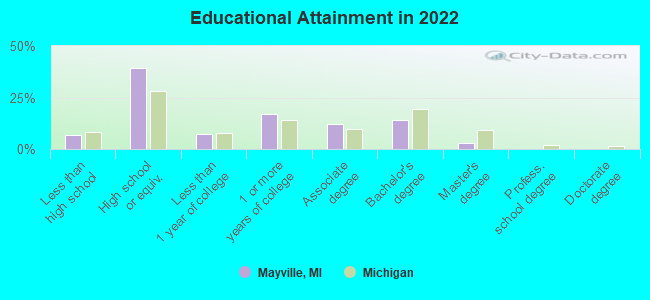
For population 25 years and over in Mayville:
- High school or higher: 92.7%
- Bachelor's degree or higher: 16.3%
- Graduate or professional degree: 2.7%
- Unemployed: 6.4%
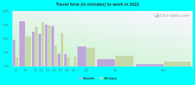
- Mean travel time to work (commute): 21.7 minutes
| Here: | 9.3 |
| Michigan average: | 11.0 |
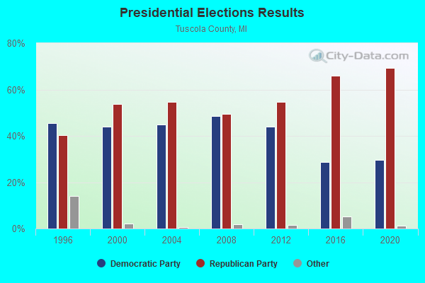
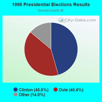
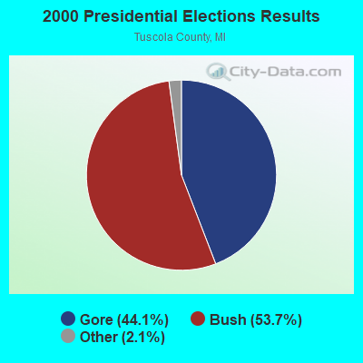

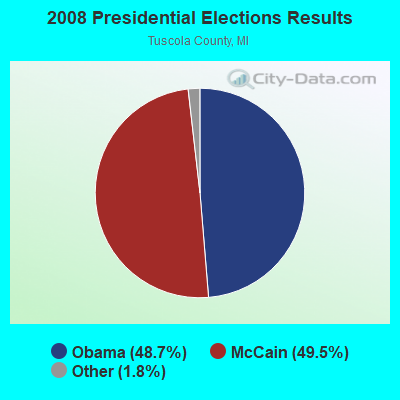
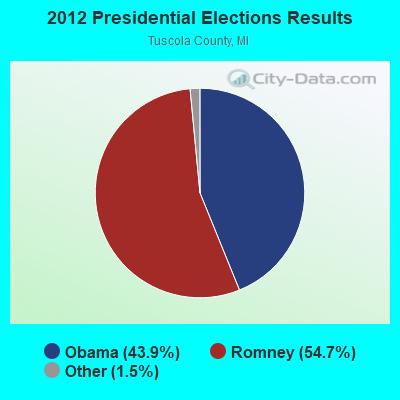

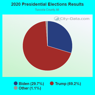
Graphs represent county-level data. Detailed 2008 Election Results
Religion statistics for Mayville, MI (based on Tuscola County data)
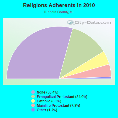
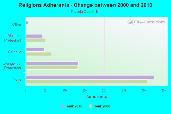
| Religion | Adherents | Congregations |
|---|---|---|
| Evangelical Protestant | 13,401 | 58 |
| Catholic | 4,756 | 7 |
| Mainline Protestant | 4,360 | 23 |
| Other | 678 | 5 |
| None | 32,534 | - |
Food Environment Statistics:
| This county: | 2.12 / 10,000 pop. |
| Michigan: | 2.34 / 10,000 pop. |
| Tuscola County: | 0.18 / 10,000 pop. |
| Michigan: | 0.18 / 10,000 pop. |
| Tuscola County: | 2.12 / 10,000 pop. |
| Michigan: | 1.52 / 10,000 pop. |
| This county: | 3.18 / 10,000 pop. |
| State: | 2.99 / 10,000 pop. |
| This county: | 4.41 / 10,000 pop. |
| Michigan: | 6.80 / 10,000 pop. |
| This county: | 9.0% |
| Michigan: | 9.7% |
| Tuscola County: | 29.2% |
| State: | 29.7% |
| Tuscola County: | 11.1% |
| Michigan: | 13.4% |
Health and Nutrition:
| Mayville: | 54.5% |
| Michigan: | 50.3% |
| Here: | 55.2% |
| Michigan: | 47.9% |
| Mayville: | 28.4 |
| Michigan: | 28.7 |
| Mayville: | 17.8% |
| Michigan: | 20.6% |
| Mayville: | 7.1% |
| State: | 10.4% |
| This city: | 6.9 |
| Michigan: | 6.8 |
| Here: | 35.4% |
| Michigan: | 34.1% |
| This city: | 62.0% |
| Michigan: | 57.0% |
| Mayville: | 80.9% |
| Michigan: | 79.6% |
More about Health and Nutrition of Mayville, MI Residents
| Local government employment and payroll (March 2022) | |||||
| Function | Full-time employees | Monthly full-time payroll | Average yearly full-time wage | Part-time employees | Monthly part-time payroll |
|---|---|---|---|---|---|
| Financial Administration | 0 | $0 | 1 | $1,174 | |
| Firefighters | 0 | $0 | 20 | $9,566 | |
| Other Government Administration | 0 | $0 | 7 | $4,042 | |
| Police Protection - Officers | 0 | $0 | 2 | $3,879 | |
| Fire - Other | 0 | $0 | 1 | $400 | |
| Police - Other | 0 | $0 | 1 | $213 | |
| Streets and Highways | 0 | $0 | 3 | $958 | |
| Totals for Government | 0 | $0 | 35 | $20,231 | |
Mayville government finances - Expenditure in 2017 (per resident):
- Current Operations - Sewerage: $427,000 ($468.72)
Local Fire Protection: $245,000 ($268.94)
Regular Highways: $183,000 ($200.88)
Police Protection: $141,000 ($154.77)
Solid Waste Management: $52,000 ($57.08)
Central Staff Services: $41,000 ($45.01)
Parks and Recreation: $31,000 ($34.03)
General - Other: $23,000 ($25.25)
Financial Administration: $4,000 ($4.39)
- General - Interest on Debt: $52,000 ($57.08)
- Total Salaries and Wages: $247,000 ($271.13)
- Water Utilities - Interest on Debt: $62,000 ($68.06)
Mayville government finances - Revenue in 2017 (per resident):
- Charges - Other: $174,000 ($191.00)
Sewerage: $82,000 ($90.01)
- Miscellaneous - General Revenue - Other: $269,000 ($295.28)
Interest Earnings: $2,000 ($2.20)
Rents: $1,000 ($1.10)
Fines and Forfeits: $1,000 ($1.10)
- Revenue - Water Utilities: $220,000 ($241.49)
- State Intergovernmental - Other: $171,000 ($187.71)
Highways: $108,000 ($118.55)
General Local Government Support: $101,000 ($110.87)
- Tax - Property: $199,000 ($218.44)
Occupation and Business License - Other: $2,000 ($2.20)
Mayville government finances - Debt in 2017 (per resident):
- Long Term Debt - Beginning Outstanding - Unspecified Public Purpose: $2,499,000 ($2743.14)
Outstanding Unspecified Public Purpose: $2,437,000 ($2675.08)
Retired Unspecified Public Purpose: $62,000 ($68.06)
Mayville government finances - Cash and Securities in 2017 (per resident):
- Other Funds - Cash and Securities: $872,000 ($957.19)
| Businesses in Mayville, MI | ||||
| Name | Count | Name | Count | |
|---|---|---|---|---|
| MasterBrand Cabinets | 1 | True Value | 1 | |
| Subway | 1 | U-Haul | 1 | |
Strongest AM radio stations in Mayville:
- WOAP (1080 AM; 50 kW; OWOSSO, MI)
- WWJ (950 AM; 50 kW; DETROIT, MI; Owner: INFINITY BROADCASTING OPERATIONS, INC.)
- WXYT (1270 AM; 50 kW; DETROIT, MI; Owner: INFINITY BROADCASTING CORP. OF DETROIT)
- WSGW (790 AM; 5 kW; SAGINAW, MI; Owner: NM LICENSING LLC)
- WKYO (1360 AM; 1 kW; CARO, MI; Owner: EDWARDS COMMUNICATIONS LC)
- WJR (760 AM; 50 kW; DETROIT, MI; Owner: ABC, INC.)
- WLSP (1530 AM; daytime; 5 kW; LAPEER, MI; Owner: REGENT BROADCASTING OF FLINT INC.)
- WFDF (910 AM; 50 kW; FLINT, MI; Owner: ABC, INC.)
- WCHB (1200 AM; 50 kW; TAYLOR, MI; Owner: RADIO ONE OF DETROIT, LLC)
- WDFN (1130 AM; 50 kW; DETROIT, MI; Owner: AMFM RADIO LICENSES, L.L.C.)
- WTRX (1330 AM; 5 kW; FLINT, MI; Owner: CITADEL BROADCASTING COMPANY)
- WFNT (1470 AM; 5 kW; FLINT, MI)
- WMAX (1440 AM; 5 kW; BAY CITY, MI; Owner: AM MEDIA SERVICES, L.L.C.)
Strongest FM radio stations in Mayville:
- WWBN (101.5 FM; TUSCOLA, MI; Owner: REGENT BROADCASTING OF FLINT, INC.)
- WHNN (96.1 FM; BAY CITY, MI; Owner: CITADEL BROADCASTING COMPANY)
- WOWE (98.9 FM; VASSAR, MI; Owner: PRAESTANTIA BROADCASTING, INC.)
- W203AX (88.5 FM; CARO, MI; Owner: CALVARY CHAPEL OF TWIN FALLS, INC.)
- WRCL (93.7 FM; FRANKENMUTH, MI; Owner: REGENT BROADCASTING OF FLINT, INC.)
- WIDL (92.1 FM; CARO, MI; Owner: EDWARDS COMMUNICATIONS LC)
- WIOG (102.5 FM; BAY CITY, MI; Owner: CITADEL BROADCASTING COMPANY)
- WUCX-FM (90.1 FM; BAY CITY, MI; Owner: CENTRAL MICHIGAN UNIVERSITY)
- WBGV (92.5 FM; MARLETTE, MI; Owner: GB BROADCASTING COMPANY)
- WFBE (95.1 FM; FLINT, MI; Owner: CITADEL BROADCASTING COMPANY)
- WQUS (103.1 FM; LAPEER, MI; Owner: REGENT BROADCASTING OF FLINT INC.)
- WKCQ (98.1 FM; SAGINAW, MI; Owner: THE MACDONALD BROADCASTING COMPANY)
- WFUM-FM (91.1 FM; FLINT, MI; Owner: THE REGENTS OF THE UNIV. OF MICHIGAN)
- WHYT (89.1 FM; IMLAY CITY, MI; Owner: MICHIGAN COMMUNITY RADIO)
- WEEG (97.3 FM; ESSEXVILLE, MI; Owner: THE MACDONALD BROADCASTING COMPANY)
TV broadcast stations around Mayville:
- WEYI-TV (Channel 25; SAGINAW, MI; Owner: WEYI BROADCASTING, LLC)
- W52CU (Channel 52; PINCONNING, MI; Owner: NTN/SAGINAW, INC.)
- WNEM-TV (Channel 5; BAY CITY, MI; Owner: MEREDITH CORPORATION)
- WXON-LP (Channel 54; FLINT, MI; Owner: P & P CABLE HOLDINGS, L.L.C.)
- W09CK (Channel 9; FLINT, MI; Owner: P & P CABLE HOLDINGS, L.L.C.)
- WDCP-TV (Channel 35; BAD AXE, MI; Owner: DELTA COLLEGE)
- WFUM (Channel 28; FLINT, MI; Owner: UNIVERSITY OF MICHIGAN)
- WSMH (Channel 66; FLINT, MI; Owner: WSMH LICENSEE, LLC)
- WJRT-TV (Channel 12; FLINT, MI; Owner: FLINT LICENSE SUBSIDIARY CORP.)
- WAQP (Channel 49; SAGINAW, MI; Owner: TCT OF MICHIGAN, INC.)
- W22CC (Channel 22; PINCONNING, MI; Owner: P & P CABLE HOLDINGS, L.L.C.)
- W69DW (Channel 69; PINCONNING, MI; Owner: NTN/SAGINAW, INC.)
- W68DH (Channel 68; PETOSKEY, MI; Owner: MS COMMUNICATIONS, LLC)
Mayville fatal accident list:
Apr 29, 2005 09:15 AM, Main, Lat: 43.336970, Lon: -83.352640, Vehicles: 1, Persons: 2, Pedestrians: 1, Fatalities: 1
Jul 13, 2001 05:11 AM, Sr-24, Vehicles: 1, Persons: 3, Pedestrians: 1, Fatalities: 1
Dec 13, 1984 07:25 PM, West Main, Vehicles: 1, Persons: 2, Fatalities: 1
- National Bridge Inventory (NBI) Statistics
- 7Number of bridges
- 23ft / 7.5mTotal length
- 8,748Total average daily traffic
- 710Total average daily truck traffic
- 13,973Total future (year 2018) average daily traffic
FCC Registered Cell Phone Towers:
1 (See the full list of FCC Registered Cell Phone Towers in Mayville)FCC Registered Antenna Towers:
25 (See the full list of FCC Registered Antenna Towers)FCC Registered Private Land Mobile Towers:
1- 1/4 Mi W Of Fostoria Rd On N Side Of Brown Rd (Lat: 43.323083 Lon: -83.376889), Type: Tower, Structure height: 91 m, Call Sign: WPGQ358, Licensee ID: L00039679,
Assigned Frequencies: 929.637 MHz, Grant Date: 02/27/2015, Expiration Date: 02/27/2025, Registrant: County Of Tuscola, 1303 Cleaver Rd, Caro, MI 48723, Phone: (989) 673-8738
FCC Registered Broadcast Land Mobile Towers:
3- MAYVILLE, MI, Lat: 43.306389 Lon: -83.358861, Call Sign: WPYU980,
Assigned Frequencies: 462.337 MHz, Grant Date: 03/10/2014, Expiration Date: 11/04/2023, Cancellation Date: 08/24/2023, Certifier: Rick Riccardi, Registrant: Aclara Technologies LLC, 30400 Solon Road, Solon, OH 44139, Phone: (440) 528-7260, Email:
- Lat: 43.333278 Lon: -83.353167, Call Sign: WQET283,
Assigned Frequencies: 72.1800 MHz, Grant Date: 04/21/2016, Expiration Date: 04/07/2026, Certifier: Robert Hiiter, Registrant: Primex Wireless, Inc, 965 Wells Street, Lake Geneva, WI 53147, Phone: (800) 537-0464
- Mayville, MI, Lat: 43.306389 Lon: -83.358861, Call Sign: WRYF415,
Assigned Frequencies: 462.337 MHz, Grant Date: 08/02/2023, Expiration Date: 08/02/2033, Certifier: Sharon A Keene, Registrant: Aclara Technologies LLC, 30400 Solon Road, Solon, OH 44139, Phone: (440) 528-7260, Email:
FCC Registered Microwave Towers:
6- 860 W Brown Rd (Lat: 43.323056 Lon: -83.376889), Structure height: 91.4 m, Call Sign: WPOQ260,
Assigned Frequencies: 955.550 MHz, Grant Date: 07/27/2018, Expiration Date: 09/29/2028, Phone: (517) 773-0368
- MAYVILLE, Lat: 43.372222 Lon: -83.385000, Call Sign: WQHC818,
Assigned Frequencies: 952.468 MHz, Grant Date: 09/27/2017, Expiration Date: 06/28/2027, Certifier: Roger Sweet, Registrant: Sensus, 450 N Gallatin Ave, Uniontown, PA 15401, Phone: (800) 638-3748, Fax: (800) 888-2403, Email:
- Mayville, Lat: 43.322778 Lon: -83.367778, Type: Tower, Structure height: 42.6 m, Call Sign: WQJM317,
Assigned Frequencies: 3650.00 MHz, Grant Date: 10/31/2008, Expiration Date: 10/31/2018, Cancellation Date: 02/16/2019, Certifier: Kerry O Penland, Registrant: Bigtube Wireless, LLC, 1223 E Caro Rd, Caro, MI 48723, Phone: (989) 673-7323, Fax: (989) 673-7150, Email:
- Mayville, 324 W Brown Rd. (Lat: 43.322361 Lon: -83.367361), Type: Tower, Structure height: 42.7 m, Overall height: 47.2 m, Call Sign: WQKN800,
Assigned Frequencies: 11215.0 MHz, 11265.0 MHz, Grant Date: 07/28/2009, Expiration Date: 07/28/2019, Cancellation Date: 09/28/2019, Certifier: Richard S Jones, Registrant: Bigtube Wireless, LLC, 1223 E. Caro Rd., Caro, MI 48723, Phone: (989) 673-7323, Fax: (989) 673-7150, Email:
- Mayville, N.E. Of Brown & Mertz Roads, 2 Km S.W. Of Mayville (Lat: 43.322778 Lon: -83.376667), Type: Gtower, Structure height: 106.7 m, Overall height: 113.7 m, Call Sign: WQNN614,
Assigned Frequencies: 11425.0 MHz, 11425.0 MHz, 11425.0 MHz, 11425.0 MHz, 11545.0 MHz, 11545.0 MHz, Grant Date: 03/31/2011, Expiration Date: 03/31/2021, Cancellation Date: 08/31/2020, Certifier: John Ogren, Registrant: Law Office Of Suzanne S. Goodwyn, Pllc, 1234 Tottenham Court, Reston, VA 20194, Phone: (703) 444-5475, Fax: (703) 991-0629, Email:
- 1078 MAYVILLE, 324 W Brown Rd. (Lat: 43.322361 Lon: -83.367361), Type: Tower, Structure height: 42.7 m, Overall height: 47.2 m, Call Sign: WQNV905,
Assigned Frequencies: 11305.0 MHz, 11305.0 MHz, 11305.0 MHz, Grant Date: 09/16/2021, Expiration Date: 06/14/2031, Certifier: Leroy Koglin, Registrant: Radyn, Inc, Silver Spring, MD 20914, Phone: (301) 493-5171, Fax: (301) 576-4553, Email:
FCC Registered Amateur Radio Licenses:
27 (See the full list of FCC Registered Amateur Radio Licenses in Mayville)2002 - 2018 National Fire Incident Reporting System (NFIRS) incidents
- Fire incident types reported to NFIRS in Mayville, MI
- 23761.6%Structure Fires
- 9123.6%Outside Fires
- 4411.4%Mobile Property/Vehicle Fires
- 133.4%Other
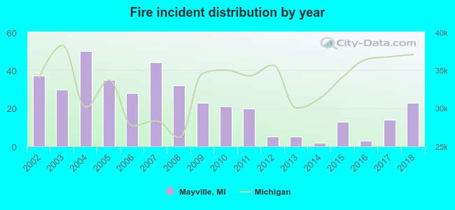 According to the data from the years 2002 - 2018 the average number of fires per year is 23. The highest number of reported fire incidents - 50 took place in 2004, and the least - 2 in 2014. The data has a dropping trend.
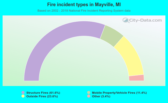 When looking into fire subcategories, the most reports belonged to: Structure Fires (61.6%), and Outside Fires (23.6%).
| Most common first names in Mayville, MI among deceased individuals | ||
| Name | Count | Lived (average) |
|---|---|---|
| William | 27 | 75.5 years |
| Robert | 23 | 66.8 years |
| John | 21 | 76.1 years |
| Charles | 21 | 74.5 years |
| George | 21 | 77.4 years |
| Mary | 18 | 77.7 years |
| Gladys | 17 | 84.0 years |
| James | 16 | 71.8 years |
| Helen | 15 | 78.5 years |
| Richard | 12 | 66.0 years |
| Most common last names in Mayville, MI among deceased individuals | ||
| Last name | Count | Lived (average) |
|---|---|---|
| Smith | 21 | 78.7 years |
| Fox | 14 | 77.4 years |
| Terbush | 11 | 71.1 years |
| Duncan | 10 | 83.5 years |
| Brown | 10 | 71.9 years |
| Steele | 10 | 81.7 years |
| Sugden | 9 | 81.8 years |
| Weiler | 9 | 78.9 years |
| Stout | 8 | 74.1 years |
| White | 8 | 77.3 years |
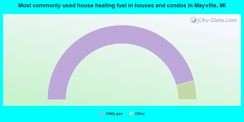
- 91.8%Utility gas
- 3.6%Bottled, tank, or LP gas
- 3.3%Electricity
- 1.3%Wood
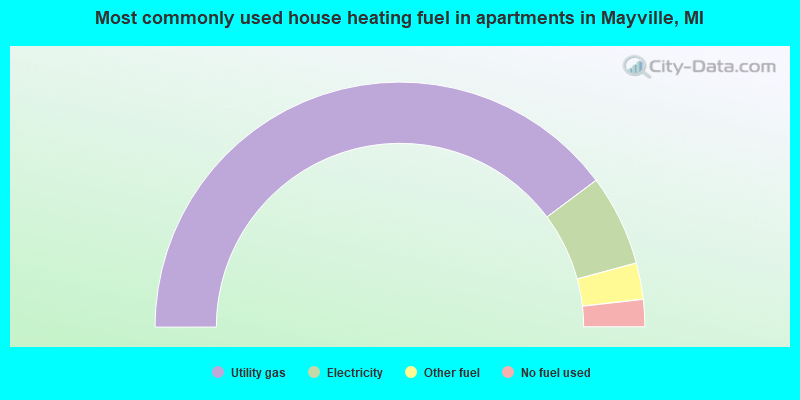
- 79.5%Utility gas
- 12.0%Electricity
- 4.8%Other fuel
- 3.6%No fuel used
Mayville compared to Michigan state average:
- Median household income below state average.
- Median house value below state average.
- Unemployed percentage below state average.
- Black race population percentage significantly below state average.
- Foreign-born population percentage significantly below state average.
- House age above state average.
- Institutionalized population percentage significantly above state average.
- Number of college students below state average.

|
|
Total of 19 patent applications in 2008-2024.