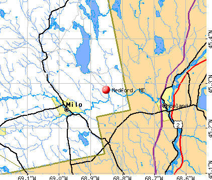
Medford, Maine
Submit your own pictures of this town and show them to the world
- OSM Map
- General Map
- Google Map
- MSN Map
Population change since 2000: +10.0%
 |
| Males: 136 | |
| Females: 118 |
| Median resident age: | 46.5 years |
| Maine median age: | 43.0 years |
Zip codes: 04463.
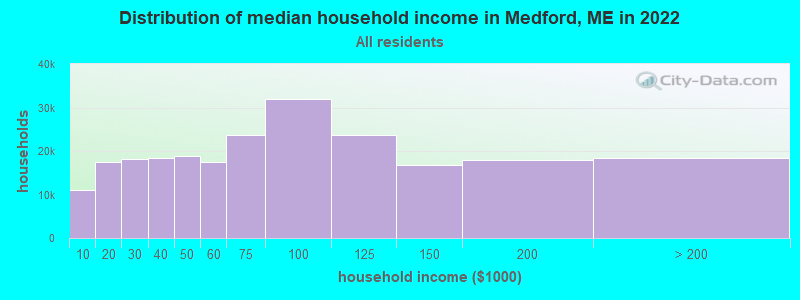
| Medford: | $53,720 |
| ME: | $69,543 |
Estimated per capita income in 2022: $29,876 (it was $12,609 in 2000)
Medford town income, earnings, and wages data
Estimated median house or condo value in 2022: $201,551 (it was $77,500 in 2000)
| Medford: | $201,551 |
| ME: | $290,600 |
Mean prices in 2022: all housing units: $203,844; detached houses: $217,964; townhouses or other attached units: $250,113; in 2-unit structures: $253,343; in 3-to-4-unit structures: $283,591; in 5-or-more-unit structures: $146,783; mobile homes: $82,683
Detailed information about poverty and poor residents in Medford, ME
Compare current foreclosures near Medford, ME:
| Photo | Address | Area | Beds / Baths | Price | Details |
|---|---|---|---|---|---|

|
#1
Howland Rd
Lagrange, ME 04453
|
- sq. feet
|
- baths - beds |
show details | |

|
#2
Lewis Trailer Park Rd
Milo, ME 04463
|
- sq. feet
|
- baths - beds |
show details | |

|
#3
Milo Rd
Sebec, ME 04481
|
- sq. feet
|
- baths - beds |
show details | |

|
#4
Range Rd
Dover Foxcroft, ME 04426
|
- sq. feet
|
- baths - beds |
show details | |

|
#5
Range Rd
Dover Foxcroft, ME 04426
|
- sq. feet
|
- baths - beds |
show details | |

|
#6
Main Rd
West Enfield, ME 04493
|
- sq. feet
|
- baths - beds |
show details | |

|
Check over 1 million property listings on Foreclosure.com!
|
browse all offers | |||

- 25098.4%White alone
- 20.8%Black alone
- 10.4%Two or more races
- 10.4%Hispanic
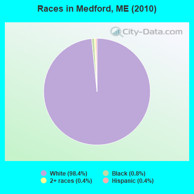
Races in Medford detailed stats: ancestries, foreign born residents, place of birth
According to our research of Maine and other state lists, there were 3 registered sex offenders living in Medford, Maine as of April 23, 2024.
The ratio of all residents to sex offenders in Medford is 85 to 1.
 Recent articles from our blog. Our writers, many of them Ph.D. graduates or candidates, create easy-to-read articles on a wide variety of topics.


 | Moving from Louisiana to Maine (50 replies) |
| Anyone from LaGrange/Three Rivers Community, ME here? (5 replies) |
| portland, me vs. burlington, vt (16 replies) |
| East/West Highway (109 replies) |
| The best place to live in Maine. (394 replies) |
| great hiking in Maine (51 replies) |
Latest news from Medford, ME collected exclusively by city-data.com from local newspapers, TV, and radio stations
Ancestries: English (19.0%), United States (16.5%), Irish (14.3%), French (11.7%), Scotch-Irish (4.3%), Scottish (4.3%).
Current Local Time: EST time zone
Incorporated on 01/31/1824
Elevation: 337 feet
Land area: 42.4 square miles.
Population density: 6.0 people per square mile (very low).
| Medford town: | 0.5% ($383) |
| Maine: | 1.5% ($1,417) |
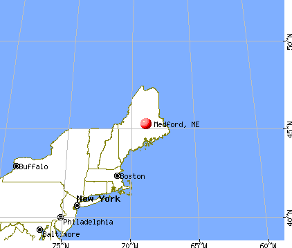
Nearest city with pop. 50,000+: Portland, ME  (131.7 miles , pop. 64,249).
Nearest city with pop. 200,000+: Boston, MA (233.0 miles , pop. 589,141).
Nearest city with pop. 1,000,000+: Bronx, NY (397.8 miles , pop. 1,332,650).
Nearest cities:
), ), )Latitude: 45.28 N, Longitude: 68.85 W
Area code commonly used in this area: 207

| Here: | 4.0% |
| Maine: | 3.4% |
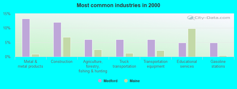
- Metal & metal products (13.3%)
- Construction (12.0%)
- Agriculture, forestry, fishing & hunting (6.0%)
- Truck transportation (6.0%)
- Transportation equipment (6.0%)
- Educational services (4.8%)
- Gasoline stations (4.8%)
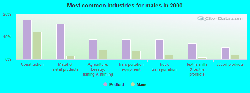
- Construction (17.5%)
- Metal & metal products (15.8%)
- Agriculture, forestry, fishing & hunting (8.8%)
- Transportation equipment (8.8%)
- Truck transportation (8.8%)
- Textile mills & textile products (7.0%)
- Wood products (5.3%)
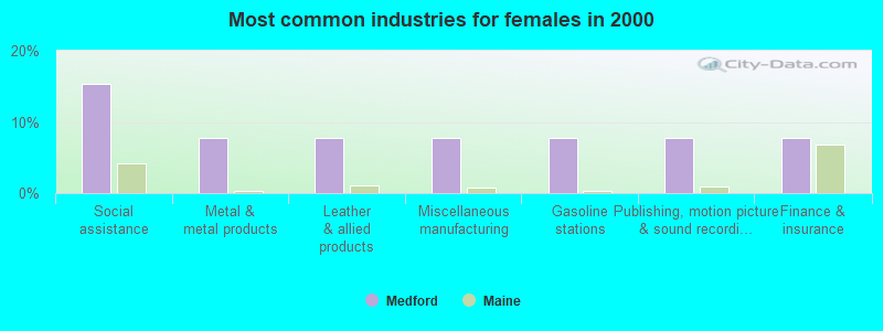
- Social assistance (15.4%)
- Metal & metal products (7.7%)
- Leather & allied products (7.7%)
- Miscellaneous manufacturing (7.7%)
- Gasoline stations (7.7%)
- Publishing, motion picture & sound recording industries (7.7%)
- Finance & insurance (7.7%)
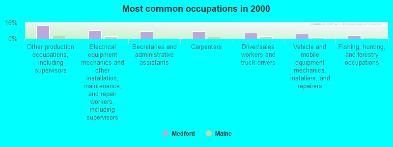
- Other production occupations, including supervisors (13.3%)
- Electrical equipment mechanics and other installation, maintenance, and repair workers, including supervisors (8.4%)
- Secretaries and administrative assistants (7.2%)
- Carpenters (7.2%)
- Driver/sales workers and truck drivers (6.0%)
- Vehicle and mobile equipment mechanics, installers, and repairers (4.8%)
- Fishing, hunting, and forestry occupations (3.6%)
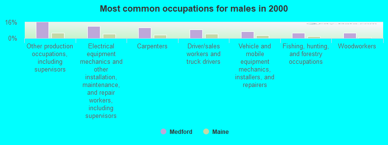
- Other production occupations, including supervisors (15.8%)
- Electrical equipment mechanics and other installation, maintenance, and repair workers, including supervisors (12.3%)
- Carpenters (10.5%)
- Driver/sales workers and truck drivers (8.8%)
- Vehicle and mobile equipment mechanics, installers, and repairers (7.0%)
- Fishing, hunting, and forestry occupations (5.3%)
- Woodworkers (5.3%)

- Secretaries and administrative assistants (23.1%)
- Preschool, kindergarten, elementary, and middle school teachers (7.7%)
- Personal appearance workers (7.7%)
- Financial managers (7.7%)
- Other financial specialists (7.7%)
- Counselors, social workers, and other community and social service specialists (7.7%)
- Other management occupations, except farmers and farm managers (7.7%)
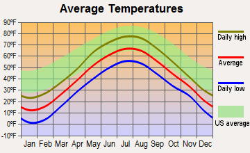
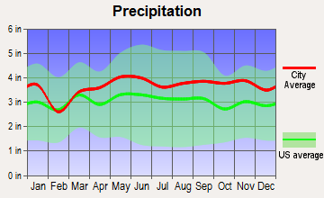
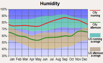
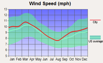
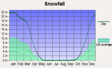
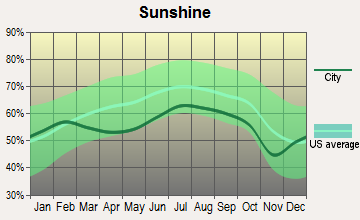
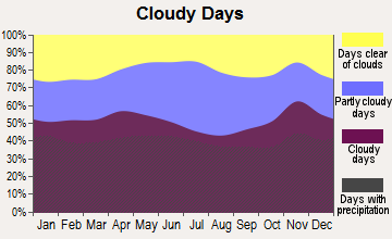
Average climate in Medford, Maine
Based on data reported by over 4,000 weather stations
(lower is better)
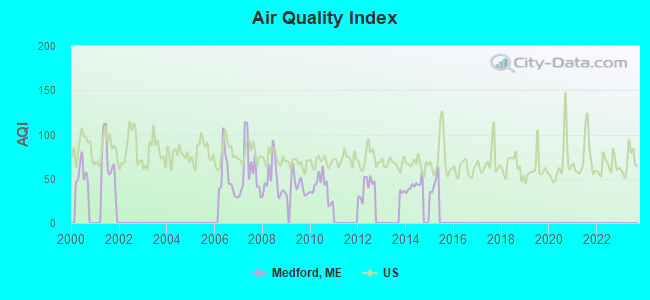
Air Quality Index (AQI) level in 2014 was 42.7. This is significantly better than average.
| City: | 42.7 |
| U.S.: | 72.6 |
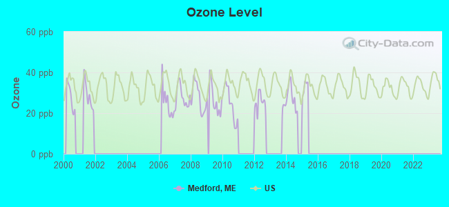
Ozone [ppb] level in 2015 was 16.3. This is significantly better than average. Closest monitor was 8.1 miles away from the city center.
| City: | 16.3 |
| U.S.: | 33.3 |
Earthquake activity:
Medford-area historical earthquake activity is significantly above Maine state average. It is 82% smaller than the overall U.S. average.On 4/20/2002 at 10:50:47, a magnitude 5.3 (5.3 ML, Depth: 3.0 mi, Class: Moderate, Intensity: VI - VII) earthquake occurred 243.3 miles away from the city center
On 4/20/2002 at 10:50:47, a magnitude 5.2 (5.2 MB, 4.2 MS, 5.2 MW, 5.0 MW) earthquake occurred 244.7 miles away from Medford center
On 10/16/2012 at 23:12:25, a magnitude 4.7 (4.7 ML, Depth: 10.0 mi, Class: Light, Intensity: IV - V) earthquake occurred 146.5 miles away from Medford center
On 10/7/1983 at 10:18:46, a magnitude 5.3 (5.1 MB, 5.3 LG, 5.1 ML) earthquake occurred 285.5 miles away from the city center
On 1/19/1982 at 00:14:42, a magnitude 4.7 (4.5 MB, 4.7 MD, 4.5 LG) earthquake occurred 183.3 miles away from the city center
On 2/26/1999 at 03:38:43, a magnitude 3.8 (3.8 LG, Depth: 2.0 mi, Class: Light, Intensity: II - III) earthquake occurred 64.2 miles away from the city center
Magnitude types: regional Lg-wave magnitude (LG), body-wave magnitude (MB), duration magnitude (MD), local magnitude (ML), surface-wave magnitude (MS), moment magnitude (MW)
Natural disasters:
The number of natural disasters in Piscataquis County (22) is greater than the US average (15).Major Disasters (Presidential) Declared: 15
Emergencies Declared: 6
Causes of natural disasters: Floods: 13, Storms: 12, Snows: 7, Heavy Rains: 2, Blizzard: 1, Ice Storm: 1, Landslide: 1, Snowfall: 1, Wind: 1, Winter Storm: 1, Other: 2 (Note: some incidents may be assigned to more than one category).
Colleges/universities with over 2000 students nearest to Medford:
- University of Maine (about 28 miles; Orono, ME; Full-time enrollment: 8,931)
- Husson University (about 32 miles; Bangor, ME; FT enrollment: 2,421)
- University of Maine at Farmington (about 77 miles; Farmington, ME; FT enrollment: 2,036)
- University of Maine at Augusta (about 80 miles; Augusta, ME; FT enrollment: 3,204)
- Saint Joseph's College of Maine (about 129 miles; Standish, ME; FT enrollment: 2,010)
- Southern Maine Community College (about 132 miles; South Portland, ME; FT enrollment: 4,666)
- University of Southern Maine (about 133 miles; Portland, ME; FT enrollment: 6,647)
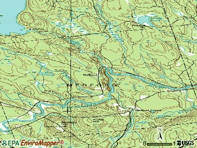
Points of interest:
Notable location: Upper Ferry (A). Display/hide its location on the map
Cemeteries: Schoodic Cemetery (1), Upper Ferry Cemetery (2), Medford Cemetery (3). Display/hide their locations on the map
Lakes and swamps: Mud Pond (A), Hawthorne Meadow (B), Palmer Meadow (C). Display/hide their locations on the map
Streams, rivers, and creeks: Alder Brook (A), Scutaze Stream (B), Schoodic Stream (C), Roberts Rocky Brook (D), Meadow Brook (E), Pleasant River (F), Cold Stream (G). Display/hide their locations on the map
| This town: | 2.4 people |
| Maine: | 2.3 people |
| This town: | 71.2% |
| Whole state: | 62.9% |
| This town: | 17.3% |
| Whole state: | 9.4% |
No gay or lesbian households reported
| This town: | 15.0% |
| Whole state: | 10.9% |
| This town: | 4.3% |
| Whole state: | 4.1% |
For population 15 years and over in Medford:
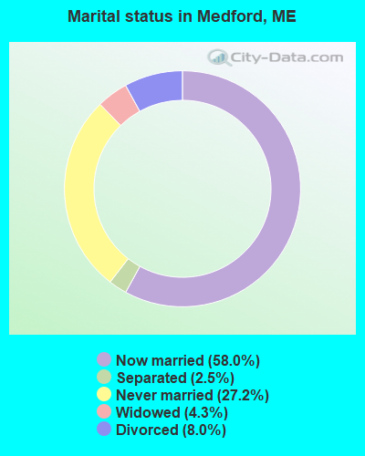
- Never married: 27.2%
- Now married: 58.0%
- Separated: 2.5%
- Widowed: 4.3%
- Divorced: 8.0%
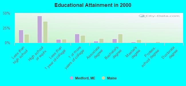
For population 25 years and over in Medford:
- High school or higher: 78.0%
- Bachelor's degree or higher: 8.3%
- Graduate or professional degree: 1.5%
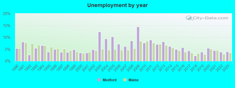
- Unemployed: 18.6%
- Mean travel time to work (commute): 35.0 minutes
| Here: | 8.3 |
| Maine average: | 11.2 |
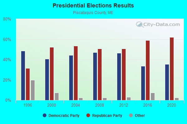
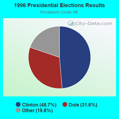
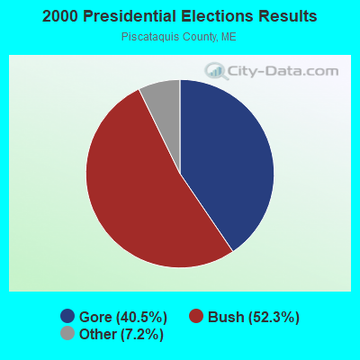


Graphs represent county-level data. Detailed 2008 Election Results
Religion statistics for Medford, ME (based on Piscataquis County data)
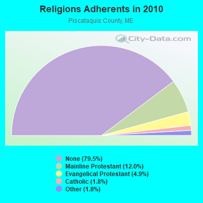
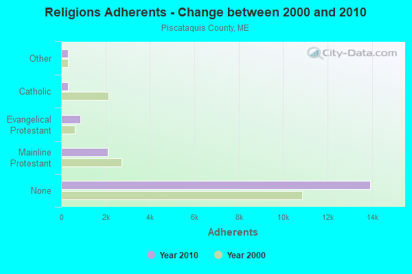
| Religion | Adherents | Congregations |
|---|---|---|
| Mainline Protestant | 2,108 | 13 |
| Evangelical Protestant | 855 | 13 |
| Catholic | 320 | 3 |
| Other | 318 | 5 |
| None | 13,934 | - |
Food Environment Statistics:
| Piscataquis County: | 5.24 / 10,000 pop. |
| Maine: | 2.80 / 10,000 pop. |
| This county: | 4.08 / 10,000 pop. |
| Maine: | 2.20 / 10,000 pop. |
| Here: | 8.74 / 10,000 pop. |
| State: | 5.75 / 10,000 pop. |
| This county: | 10.49 / 10,000 pop. |
| Maine: | 11.02 / 10,000 pop. |
| Here: | 8.4% |
| State: | 8.2% |
| Piscataquis County: | 27.5% |
| Maine: | 25.0% |
Strongest AM radio stations in Medford:
- WZON (620 AM; 5 kW; BANGOR, ME; Owner: THE ZONE CORPORATION)
- WABI (910 AM; 5 kW; BANGOR, ME; Owner: CLEAR CHANNEL BROADCASTING LICENSES, INC.)
- WSKW (1160 AM; 10 kW; SKOWHEGAN, ME; Owner: MOUNTAIN WIRELESS, INCORPORATED)
- WRKO (680 AM; 50 kW; BOSTON, MA; Owner: ENTERCOM BOSTON LICENSE, LLC)
- WTME (780 AM; 10 kW; RUMFORD, ME; Owner: MOUNTAIN VALLEY BROADCASTING, INC.)
- WDEA (1370 AM; 5 kW; ELLSWORTH, ME; Owner: CUMULUS LICENSING CORP.)
- WSYY (1240 AM; 1 kW; MILLINOCKET, ME; Owner: KATAHDIN BROADCASTING, INC.)
- WEEI (850 AM; 50 kW; BOSTON, MA; Owner: ENTERCOM BOSTON LICENSE, LLC)
- WBZ (1030 AM; 50 kW; BOSTON, MA; Owner: INFINITY BROADCASTING OPERATIONS, INC.)
- WCHP (760 AM; 35 kW; CHAMPLAIN, NY; Owner: CHAMPLAIN RADIO, INC.)
- WNNZ (640 AM; 50 kW; WESTFIELD, MA; Owner: CLEAR CHANNEL BROADCASTING LICENSES, INC.)
- WCRN (830 AM; 50 kW; WORCESTER, MA; Owner: CARTER BROADCASTING CORPORATION)
- WREM (710 AM; daytime; 5 kW; MONTICELLO, ME; Owner: ALLAN H WEINER)
Strongest FM radio stations in Medford:
- WVOM (103.9 FM; HOWLAND, ME; Owner: CLEAR CHANNEL BROADCASTING LICENSES, INC.)
- WHCF (88.5 FM; BANGOR, ME; Owner: BANGOR BAPTIST CHURCH)
- WQCB (106.5 FM; BREWER, ME; Owner: CUMULUS LICENSING CORP.)
- WBZN (107.3 FM; OLD TOWN, ME; Owner: CUMULUS LICENSING CORP.)
- WHMX (105.7 FM; LINCOLN, ME; Owner: BANGOR BAPTIST CHURCH)
- WWBX (97.1 FM; BANGOR, ME; Owner: CLEAR CHANNEL BROADCASTING LICENSES, INC.)
- WGUY (102.1 FM; DEXTER, ME; Owner: CONCORD MEDIA GROUP, INC.)
- WSYY-FM (94.9 FM; MILLINOCKET, ME; Owner: KATAHDIN COMMUNICATIONS, INC.)
- WDME-FM (103.1 FM; DOVER-FOXCROFT, ME; Owner: THE ZONE CORPORATION)
- WMEH (90.9 FM; BANGOR, ME; Owner: MAINE PUBLIC BROADCASTING CORPORATION)
- WWMJ (95.7 FM; ELLSWORTH, ME; Owner: CUMULUS LICENSING CORP.)
- WKIT-FM (100.3 FM; BREWER, ME; Owner: THE ZONE CORPORATION)
- WEZQ (92.9 FM; BANGOR, ME; Owner: CUMULUS LICENSING CORP.)
- National Bridge Inventory (NBI) Statistics
- 1Number of bridges
- 3ft / 0.9mTotal length
- 144Total average daily traffic
- 7Total average daily truck traffic
- 230Total future (year 2036) average daily traffic
FCC Registered Microwave Towers:
1- Railroad Bed, Railroad Bed Rd (Lat: 45.333944 Lon: -68.910583), Type: Building, Structure height: 8 m, Overall height: 10 m, Call Sign: WQZP679,
Assigned Frequencies: 11155.0 MHz, 11155.0 MHz, 11155.0 MHz, 11155.0 MHz, 11155.0 MHz, 11155.0 MHz, 11155.0 MHz, 11155.0 MHz, 11155.0 MHz, 11155.0 MHz, Grant Date: 06/28/2017, Expiration Date: 06/28/2027, Certifier: Andrew H Hinkley, Registrant: Intelpath, 111 Fuller Rd, Hinsdale, IL 60521, Phone: (312) 841-9188, Email:
FCC Registered Amateur Radio Licenses:
2- Call Sign: KC8UTQ, Previous Call Sign: N0PQP, Licensee ID: L00570851, Grant Date: 09/27/2022, Expiration Date: 09/27/2032, Certifier: Leonard J Gilbert, Registrant: Leonard J Gilbert, 228 North Rd, Medford, ME 04463
- Call Sign: KC1HKA, Licensee ID: L02031882, Grant Date: 04/12/2017, Expiration Date: 04/12/2027, Certifier: Jaimie Cabral, Registrant: Jaimie Cabral, 12 Angel Lane, Medford, ME 04463
FAA Registered Aircraft:
1- Aircraft: WING LEONARD A ZENITH CH-701 (Category: Land, Seats: 2, Weight: Up to 12,499 Pounds), Engine: ROTAX 912 (80 HP) (4 Cycle)
N-Number: 71LW, N71LW, N-71LW, Serial Number: 001, Airworthiness Date: 06/20/2008, Certificate Issue Date: 04/21/2010
Registrant (Individual): Darryl E Luce, 1345 Medford Center Rd, Medford, ME 04463
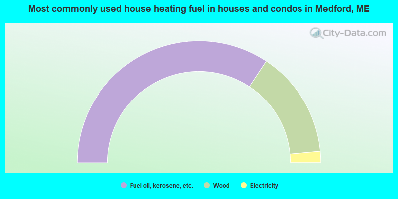
- 68.7%Fuel oil, kerosene, etc.
- 28.4%Wood
- 3.0%Electricity
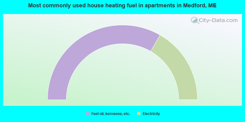
- 66.7%Fuel oil, kerosene, etc.
- 33.3%Electricity
Medford compared to Maine state average:
- Black race population percentage below state average.
- Hispanic race population percentage significantly below state average.
- Foreign-born population percentage significantly below state average.
- Renting percentage significantly below state average.
- Length of stay since moving in significantly above state average.
- Number of rooms per house significantly below state average.
- House age significantly below state average.
- Number of college students significantly below state average.
- Percentage of population with a bachelor's degree or higher significantly below state average.