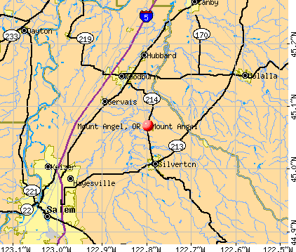
Mount Angel, Oregon
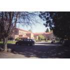
Mount Angel: Mount Angel Abbey & Seminary
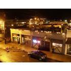
Mount Angel: Mount Angel at night
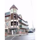
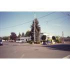
Mount Angel: Edelweiss Village Apt Complex and Glockenspiel. Central downtown Mount Angel.
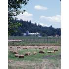
Mount Angel: Hops and hayfields. Lots of each here.
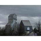
Mount Angel: Grain elevator at south city edge
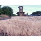
Mount Angel: The old train station. Clock has chimes hourly.
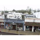
Mount Angel: Mount Angel City Hall
Mount Angel: Frank-N-Stein's Pub, Karaoke central and home of the great burger.
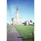
Mount Angel: Saint Mary Parish
- add
your


Submit your own pictures of this city and show them to the world
- OSM Map
- General Map
- Google Map
- MSN Map
Population change since 2000: +8.9%
 |
| Males: 1,425 | |
| Females: 1,975 |
| Median resident age: | 39.0 years |
| Oregon median age: | 40.5 years |
Zip codes: 97362.
| Mount Angel: | $54,657 |
| OR: | $75,657 |
Estimated per capita income in 2022: $29,124 (it was $15,535 in 2000)
Mount Angel city income, earnings, and wages data
Estimated median house or condo value in 2022: $416,614 (it was $120,900 in 2000)
| Mount Angel: | $416,614 |
| OR: | $475,600 |
Mean prices in 2022: all housing units: $403,511; detached houses: $435,571; mobile homes: $119,044
Median gross rent in 2022: $972.
(19.7% for White Non-Hispanic residents, 3.5% for Hispanic or Latino residents, 10.3% for other race residents, 9.2% for two or more races residents)
Detailed information about poverty and poor residents in Mount Angel, OR
Compare current foreclosures near Mount Angel, OR:
| Photo | Address | Area | Beds / Baths | Price | Details |
|---|---|---|---|---|---|

|
#1
Willow Ct
Mount Angel, OR 97362
|
1,404 sq. feet
|
2 baths 3 beds |
show details | |

|
#2
N Pershing St
Mount Angel, OR 97362
|
- sq. feet
|
- baths - beds |
show details | |

|
#3
Towers Ln Apt 2248
Mount Angel, OR 97362
|
- sq. feet
|
- baths - beds |
show details | |

|
#4
Palm Ave
Woodburn, OR 97071
|
1,025 sq. feet
|
1 baths 3 beds |
show details | |

|
#5
20th St NE
Salem, OR 97301
|
1,020 sq. feet
|
2 baths 3 beds |
show details | |

|
#6
Hazelnut Ridge Rd NE
Silverton, OR 97381
|
1,674 sq. feet
|
2 baths 3 beds |
show details | |

|
#7
Regal Dr NE
Salem, OR 97301
|
1,732 sq. feet
|
3 baths 5 beds |
show details | |

|
#8
NE Dog Ridge Rd
Newberg, OR 97132
|
4,208 sq. feet
|
3 baths 3 beds |
show details | |

|
#9
Golden Eagle St NW
Salem, OR 97304
|
2,753 sq. feet
|
3 baths 4 beds |
show details | |

|
#10
S Acer Ln
Molalla, OR 97038
|
1,056 sq. feet
|
1 baths 3 beds |
show details |
| Photo | Address | Area | Beds / Baths | Price | Details |
|---|---|---|---|---|---|

|
#11
Steven St
Woodburn, OR 97071
|
1,476 sq. feet
|
2 baths 3 beds |
show details | |

|
#12
Blaine St
Woodburn, OR 97071
|
1,056 sq. feet
|
1 baths 4 beds |
show details | |

|
#13
Hazelgreen Rd NE
Salem, OR 97305
|
1,236 sq. feet
|
2 baths 3 beds |
show details | |

|
#14
Holly Loop SE
Turner, OR 97392
|
1,054 sq. feet
|
2 baths 3 beds |
show details | |

|
#15
Norman Ave NE
Salem, OR 97301
|
1,329 sq. feet
|
2 baths 3 beds |
show details | |

|
#16
Grassland Ct NE
Salem, OR 97305
|
2,705 sq. feet
|
3 baths 3 beds |
show details | |

|
#17
Waller St SE
Salem, OR 97302
|
1,112 sq. feet
|
1 baths 3 beds |
show details | |

|
#18
Palimino Ave
Woodburn, OR 97071
|
2,181 sq. feet
|
2 baths 4 beds |
show details | |

|
#19
E Del Mar
Aumsville, OR 97325
|
1,651 sq. feet
|
2 baths 4 beds |
show details | |

|
#20
Webb Lake Dr NE
Silverton, OR 97381
|
1,864 sq. feet
|
2 baths 3 beds |
show details |
| Photo | Address | Area | Beds / Baths | Price | Details |
|---|---|---|---|---|---|

|
#21
Vista Ave SE
Salem, OR 97302
|
1,299 sq. feet
|
1 baths 2 beds |
show details | |

|
#22
Pierce Dr N
Salem, OR 97303
|
1,432 sq. feet
|
2 baths 3 beds |
show details | |

|
#23
Krystie Ct NE
Salem, OR 97303
|
1,008 sq. feet
|
1 baths 3 beds |
show details | |

|
#24
Brooks Ave NE
Salem, OR 97303
|
1,200 sq. feet
|
2 baths 4 beds |
show details | |

|
#25
Wooddale Ave NE
Salem, OR 97301
|
1,193 sq. feet
|
1 baths 3 beds |
show details | |

|
#26
13th St SE
Salem, OR 97302
|
2,788 sq. feet
|
2 baths 2 beds |
show details | |

|
#27
N Molalla Ave
Molalla, OR 97038
|
2,416 sq. feet
|
2 baths 3 beds |
show details | |

|
#28
Summit Ave NW
Salem, OR 97304
|
2,156 sq. feet
|
2 baths 4 beds |
show details | |

|
#29
Center St NE
Salem, OR 97301
|
1,056 sq. feet
|
1 baths 3 beds |
show details | |

|
#30
Sandys Ln SE
Salem, OR 97317
|
4,297 sq. feet
|
3 baths 4 beds |
show details |
| Photo | Address | Area | Beds / Baths | Price | Details |
|---|---|---|---|---|---|

|
#31
Bluff Ave SE
Salem, OR 97302
|
1,620 sq. feet
|
2 baths 3 beds |
show details | |

|
#32
Lockhaven Dr NE
Salem, OR 97303
|
1,219 sq. feet
|
2 baths 2 beds |
show details | |

|
#33
Piedmont Ave NW
Salem, OR 97304
|
1,398 sq. feet
|
1 baths 3 beds |
show details | |

|
#34
Evans Ave N
Salem, OR 97303
|
1,240 sq. feet
|
2 baths 3 beds |
show details | |

|
#35
Tierra Dr NE
Salem, OR 97301
|
1,000 sq. feet
|
1 baths 3 beds |
show details | |

|
#36
W Heintz St
Molalla, OR 97038
|
988 sq. feet
|
1 baths 3 beds |
show details | |

|
#37
39th Ave NE
Salem, OR 97301
|
1,145 sq. feet
|
1 baths 3 beds |
show details | |

|
#38
NE Cherry St
Sublimity, OR 97385
|
2,261 sq. feet
|
2 baths 4 beds |
show details | |

|
#39
Boaz Ln NW
Salem, OR 97304
|
1,782 sq. feet
|
2 baths 3 beds |
show details | |

|
#40
Glory Ridge St NW
Salem, OR 97304
|
2,367 sq. feet
|
2 baths 3 beds |
show details |
| Photo | Address | Area | Beds / Baths | Price | Details |
|---|---|---|---|---|---|

|
#41
Auburn Rd NE Unit 154
Salem, OR 97301
|
1,440 sq. feet
|
2 baths 3 beds |
show details | |

|
#42
Anita Dr NE
Salem, OR 97301
|
1,120 sq. feet
|
1 baths 3 beds |
show details | |

|
#43
Montrose Ave NW
Salem, OR 97304
|
2,044 sq. feet
|
1 baths 3 beds |
show details | |

|
#44
Parkway Dr NW # 310
Salem, OR 97304
|
1,968 sq. feet
|
2 baths 3 beds |
show details | |

|
#45
Verda Ln NE
Salem, OR 97303
|
1,905 sq. feet
|
2 baths 4 beds |
show details | |

|
#46
Whispering Pines Loop SE
Salem, OR 97317
|
1,304 sq. feet
|
2 baths 3 beds |
show details | |

|
#47
Park Ave NE
Salem, OR 97301
|
1,624 sq. feet
|
2 baths 6 beds |
show details | |

|
#48
State St Unit 3
Salem, OR 97301
|
1,008 sq. feet
|
2 baths 3 beds |
show details | |

|
#49
Straw Dr N
Salem, OR 97303
|
1,732 sq. feet
|
1 baths 3 beds |
show details | |

|
Check over 1 million property listings on Foreclosure.com!
|
browse all offers | |||


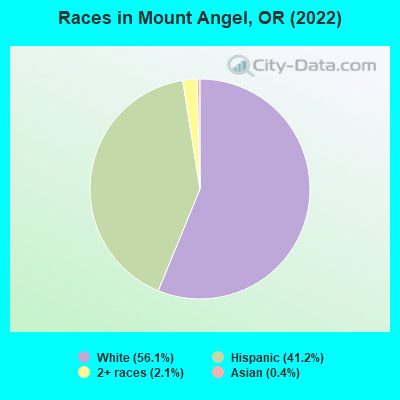
- 1,92056.1%White alone
- 1,40841.2%Hispanic
- 732.1%Two or more races
- 140.4%Asian alone
Races in Mount Angel detailed stats: ancestries, foreign born residents, place of birth
Type |
2009 |
2010 |
2011 |
2012 |
2013 |
2014 |
2015 |
2016 |
2017 |
2018 |
2019 |
2020 |
2021 |
2022 |
|---|---|---|---|---|---|---|---|---|---|---|---|---|---|---|
| Murders (per 100,000) | 0 (0.0) | 0 (0.0) | 1 (30.1) | 0 (0.0) | 0 (0.0) | 1 (29.3) | 0 (0.0) | 0 (0.0) | 0 (0.0) | 0 (0.0) | 0 (0.0) | 0 (0.0) | 0 (0.0) | 1 (29.4) |
| Rapes (per 100,000) | 0 (0.0) | 3 (91.3) | 0 (0.0) | 0 (0.0) | 1 (29.4) | 3 (88.0) | 1 (29.3) | 0 (0.0) | 1 (28.0) | 2 (56.2) | 0 (0.0) | 0 (0.0) | 2 (54.4) | 2 (58.8) |
| Robberies (per 100,000) | 1 (28.5) | 1 (30.4) | 1 (30.1) | 1 (29.9) | 1 (29.4) | 0 (0.0) | 0 (0.0) | 1 (29.0) | 0 (0.0) | 1 (28.1) | 0 (0.0) | 0 (0.0) | 0 (0.0) | 0 (0.0) |
| Assaults (per 100,000) | 4 (113.9) | 12 (365.2) | 12 (361.3) | 10 (299.0) | 6 (176.2) | 12 (351.8) | 4 (117.2) | 7 (203.0) | 4 (112.1) | 2 (56.2) | 4 (110.5) | 7 (191.9) | 3 (81.6) | 4 (117.5) |
| Burglaries (per 100,000) | 8 (227.9) | 7 (213.0) | 9 (271.0) | 14 (418.5) | 10 (293.7) | 8 (234.5) | 5 (146.5) | 9 (261.0) | 8 (224.2) | 7 (196.7) | 5 (138.1) | 3 (82.3) | 4 (108.8) | 1 (29.4) |
| Thefts (per 100,000) | 42 (1,196) | 65 (1,978) | 40 (1,204) | 58 (1,734) | 49 (1,439) | 60 (1,759) | 41 (1,201) | 29 (841.1) | 36 (1,009) | 33 (927.2) | 35 (966.6) | 24 (658.1) | 12 (326.4) | 20 (587.7) |
| Auto thefts (per 100,000) | 5 (142.4) | 2 (60.9) | 1 (30.1) | 2 (59.8) | 3 (88.1) | 7 (205.2) | 2 (58.6) | 3 (87.0) | 9 (252.2) | 5 (140.5) | 4 (110.5) | 7 (191.9) | 2 (54.4) | 2 (58.8) |
| Arson (per 100,000) | 0 (0.0) | 3 (91.3) | 0 (0.0) | 1 (29.9) | 0 (0.0) | 1 (29.3) | 2 (58.6) | 0 (0.0) | 0 (0.0) | 0 (0.0) | 1 (27.6) | 0 (0.0) | 1 (27.2) | 3 (88.2) |
| City-Data.com crime index | 106.5 | 254.1 | 211.1 | 172.2 | 152.7 | 302.6 | 109.8 | 108.2 | 121.0 | 126.7 | 79.3 | 85.8 | 84.9 | 159.6 |
The City-Data.com crime index weighs serious crimes and violent crimes more heavily. Higher means more crime, U.S. average is 246.1. It adjusts for the number of visitors and daily workers commuting into cities.

Crime rate in Mount Angel detailed stats: murders, rapes, robberies, assaults, burglaries, thefts, arson
Full-time law enforcement employees in 2021, including police officers: 7 (6 officers - 6 male; 0 female).
| Officers per 1,000 residents here: | 1.63 |
| Oregon average: | 1.48 |
 Recent articles from our blog. Our writers, many of them Ph.D. graduates or candidates, create easy-to-read articles on a wide variety of topics.


 | Impressions of Woodburn (24 replies) |
Latest news from Mount Angel, OR collected exclusively by city-data.com from local newspapers, TV, and radio stations
Ancestries: German (15.5%), English (8.5%), Russian (7.3%), European (6.4%), Norwegian (5.0%), Irish (3.6%).
Current Local Time: PST time zone
Elevation: 168 feet
Land area: 0.96 square miles.
Population density: 3,556 people per square mile (average).
438 residents are foreign born (11.6% Latin America).
| This city: | 12.8% |
| Oregon: | 9.8% |
Median real estate property taxes paid for housing units with mortgages in 2022: $3,534 (0.9%)
Median real estate property taxes paid for housing units with no mortgage in 2022: $2,928 (0.7%)
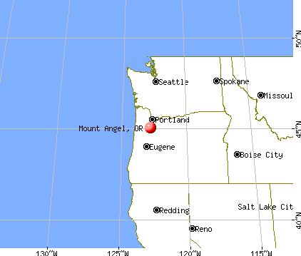
Nearest city with pop. 50,000+: Salem, OR  (14.8 miles , pop. 136,924).
Nearest city with pop. 200,000+: Northwest Clackamas, OR (24.3 miles , pop. 224,220).
Nearest city with pop. 1,000,000+: Los Angeles, CA (795.0 miles , pop. 3,694,820).
Nearest cities:
), ), )Latitude: 45.07 N, Longitude: 122.80 W
Area code: 503


Mount Angel, Oregon accommodation & food services, waste management - Economy and Business Data
Single-family new house construction building permits:
- 2022: 35 buildings, average cost: $332,200
- 2021: 18 buildings, average cost: $274,200
- 2020: 14 buildings, average cost: $242,500
- 2019: 20 buildings, average cost: $277,900
- 2018: 18 buildings, average cost: $190,500
- 2017: 12 buildings, average cost: $192,600
- 2016: 10 buildings, average cost: $265,000
- 2015: 6 buildings, average cost: $205,700
- 2014: 6 buildings, average cost: $229,400
- 2013: 4 buildings, average cost: $227,300
- 2011: 1 building, cost: $147,000
- 2010: 3 buildings, average cost: $227,000
- 2009: 1 building, cost: $450,000
- 2008: 3 buildings, average cost: $194,300
- 2007: 23 buildings, average cost: $189,600
- 2006: 29 buildings, average cost: $191,800
- 2005: 8 buildings, average cost: $164,600
- 2004: 11 buildings, average cost: $187,200
- 2003: 8 buildings, average cost: $147,300
- 2002: 16 buildings, average cost: $160,900
- 2001: 21 buildings, average cost: $107,400
- 2000: 8 buildings, average cost: $136,600
- 1999: 2 buildings, average cost: $119,200
- 1998: 8 buildings, average cost: $132,800
- 1997: 1 building, cost: $108,000


| Here: | 3.9% |
| Oregon: | 3.9% |


Population change in the 1990s: +333 (+11.9%).

- Educational services (9.6%)
- Agriculture, forestry, fishing & hunting (8.7%)
- Health care (7.4%)
- Accommodation & food services (7.0%)
- Construction (6.4%)
- Administrative & support & waste management services (4.8%)
- Wood products (3.8%)

- Agriculture, forestry, fishing & hunting (12.0%)
- Construction (10.9%)
- Administrative & support & waste management services (7.1%)
- Accommodation & food services (6.4%)
- Wood products (5.7%)
- Educational services (4.7%)
- Food (4.3%)

- Educational services (15.5%)
- Health care (14.1%)
- Accommodation & food services (7.7%)
- Social assistance (7.1%)
- Agriculture, forestry, fishing & hunting (4.6%)
- Religious, grantmaking, civic, professional, similar organizations (4.0%)
- Food & beverage stores (3.8%)

- Cooks and food preparation workers (5.9%)
- Other production occupations, including supervisors (5.8%)
- Building and grounds cleaning and maintenance occupations (4.9%)
- Agricultural workers, including supervisors (4.6%)
- Other sales and related occupations, including supervisors (3.3%)
- Electrical equipment mechanics and other installation, maintenance, and repair workers, including supervisors (3.1%)
- Other office and administrative support workers, including supervisors (2.9%)

- Other production occupations, including supervisors (7.0%)
- Agricultural workers, including supervisors (6.9%)
- Building and grounds cleaning and maintenance occupations (5.3%)
- Cooks and food preparation workers (5.0%)
- Vehicle and mobile equipment mechanics, installers, and repairers (5.0%)
- Electrical equipment mechanics and other installation, maintenance, and repair workers, including supervisors (5.0%)
- Driver/sales workers and truck drivers (4.6%)

- Cooks and food preparation workers (6.9%)
- Secretaries and administrative assistants (6.2%)
- Preschool, kindergarten, elementary, and middle school teachers (5.9%)
- Other office and administrative support workers, including supervisors (5.7%)
- Building and grounds cleaning and maintenance occupations (4.5%)
- Other production occupations, including supervisors (4.3%)
- Information and record clerks, except customer service representatives (4.1%)
Average climate in Mount Angel, Oregon
Based on data reported by over 4,000 weather stations


|
|

(lower is better)

Air Quality Index (AQI) level in 2023 was 78.7. This is about average.
| City: | 78.7 |
| U.S.: | 72.6 |


Particulate Matter (PM2.5) [µg/m3] level in 2023 was 4.97. This is significantly better than average. Closest monitor was 9.9 miles away from the city center.
| City: | 4.97 |
| U.S.: | 8.11 |
Earthquake activity:
Mount Angel-area historical earthquake activity is significantly above Oregon state average. It is 1423% greater than the overall U.S. average.On 4/13/1949 at 19:55:42, a magnitude 7.0 (7.0 UK, Class: Major, Intensity: VIII - XII) earthquake occurred 151.5 miles away from the city center, causing $80,000,000 total damage
On 2/28/2001 at 18:54:32, a magnitude 6.8 (6.5 MB, 6.6 MS, 6.8 MW, Class: Strong, Intensity: VII - IX) earthquake occurred 140.2 miles away from the city center, causing $2,000,000,000 total damage and $305,000,000 insured losses
On 2/28/2001 at 18:54:32, a magnitude 6.8 (6.8 MD, Depth: 32.2 mi) earthquake occurred 143.9 miles away from the city center
On 1/31/1922 at 13:17:28, a magnitude 7.6 (7.6 UK) earthquake occurred 332.8 miles away from the city center
On 11/8/1980 at 10:27:34, a magnitude 7.2 (6.2 MB, 7.2 MS, 7.2 MW, 7.0 ML) earthquake occurred 284.1 miles away from Mount Angel center
On 4/29/1965 at 15:28:43, a magnitude 6.6 (6.6 UK) earthquake occurred 157.1 miles away from Mount Angel center, causing $28,000,000 total damage
Magnitude types: body-wave magnitude (MB), duration magnitude (MD), local magnitude (ML), surface-wave magnitude (MS), moment magnitude (MW)
Natural disasters:
The number of natural disasters in Marion County (10) is smaller than the US average (15).Major Disasters (Presidential) Declared: 8
Emergencies Declared: 1
Causes of natural disasters: Floods: 4, Winter Storms: 3, Landslides: 2, Mudslides: 2, Snows: 2, Storms: 2, Earthquake: 1, Fire: 1, Heavy Rain: 1, Hurricane: 1, Wind: 1, Other: 1 (Note: some incidents may be assigned to more than one category).
Hospitals and medical centers in Mount Angel:
- PROVIDENCE BENEDICTINE HOME HEALTH (570 SOUTH MAIN STREET)
- PROVIDENCE BENEDICTINE NC (540 SOUTH MAIN STREET)
Other hospitals and medical centers near Mount Angel:
- MARQUIS CARE AT SILVER GARDENS (Nursing Home, about 5 miles away; SILVERTON, OR)
- SILVERTON HOSPITAL Acute Care Hospitals (about 5 miles away; SILVERTON, OR)
- RIVERVIEW CONVALESCENT CENTER (Nursing Home, about 6 miles away; SILVERTON, OR)
- FRENCH PRAIRIE CARE CENTER (Nursing Home, about 7 miles away; WOODBURN, OR)
- FRENCH PRAIRIE NURSING AND REHABILITATION CENTER (Nursing Home, about 7 miles away; WOODBURN, OR)
- WOODBURN DIALYSIS (Dialysis Facility, about 7 miles away; WOODBURN, OR)
- MOLALLA MANOR CARE CENTER (Nursing Home, about 12 miles away; MOLALLA, OR)
Colleges/universities with over 2000 students nearest to Mount Angel:
- Chemeketa Community College (about 11 miles; Salem, OR; Full-time enrollment: 10,746)
- Willamette University (about 15 miles; Salem, OR; FT enrollment: 2,551)
- Pioneer Pacific College (about 18 miles; Wilsonville, OR; FT enrollment: 2,194)
- George Fox University (about 19 miles; Newberg, OR; FT enrollment: 2,954)
- Clackamas Community College (about 21 miles; Oregon City, OR; FT enrollment: 4,261)
- Portland Community College (about 26 miles; Portland, OR; FT enrollment: 23,600)
- Western Oregon University (about 27 miles; Monmouth, OR; FT enrollment: 5,131)
Points of interest:
Notable locations in Mount Angel: Mount Angel Public Works Department Office (A), Mount Angel Public Library (B), Mount Angel Municipal Court (C), Mount Angel City Hall (D), Mount Angel Fire District (E). Display/hide their locations on the map
Cemeteries: Mount Angel Cemetery (1), Mount Calvary Cemetery (2). Display/hide their locations on the map
Parks in Mount Angel include: John B Humpert Park (1), Fisher Memorial Park (2), Ebner County Park (3). Display/hide their locations on the map
Drinking water stations with addresses in Mount Angel and their reported violations in the past:
MOUNT ANGEL, CITY OF (Population served: 3,785, Groundwater):Past monitoring violations:
- Monitoring and Reporting (DBP) - Between JAN-2006 and DEC-2006, Contaminant: Total Haloacetic Acids (HAA5). Follow-up actions: St Compliance achieved (2 times from SEP-24-2008 to NOV-26-2008)
- Monitoring and Reporting (DBP) - Between JAN-2006 and DEC-2006, Contaminant: TTHM. Follow-up actions: St Compliance achieved (2 times from SEP-24-2008 to NOV-26-2008)
- Initial, Follow-up, or Routine Source Water M/R - In DEC-01-1994, Contaminant: Lead and Copper Rule. Follow-up actions: Fed Compliance achieved (JUL-19-2006), State No Longer Subject to Rule (DEC-25-2010)
| This city: | 2.6 people |
| Oregon: | 2.5 people |
| This city: | 58.7% |
| Whole state: | 63.4% |
| This city: | 5.5% |
| Whole state: | 8.0% |
Likely homosexual households (counted as self-reported same-sex unmarried-partner households)
- Lesbian couples: 0.0% of all households
- Gay men: 0.2% of all households
People in group quarters in Mount Angel in 2010:
- 89 people in nursing facilities/skilled-nursing facilities
- 59 people in other noninstitutional facilities
- 46 people in emergency and transitional shelters (with sleeping facilities) for people experiencing homelessness
- 9 people in group homes intended for adults
People in group quarters in Mount Angel in 2000:
- 90 people in nursing homes
- 86 people in other noninstitutional group quarters
- 26 people in religious group quarters
- 10 people in homes for the mentally retarded
Banks with branches in Mount Angel (2011 data):
- Wells Fargo Bank, National Association: Mt. Angel Branch at 245 North Main Street, branch established on 1970/10/02. Info updated 2011/04/05: Bank assets: $1,161,490.0 mil, Deposits: $905,653.0 mil, headquarters in Sioux Falls, SD, positive income, 6395 total offices, Holding Company: Wells Fargo & Company
- West Coast Bank: Mt. Angel Branch at 160 E. Charles St, branch established on 2006/06/23. Info updated 2010/09/16: Bank assets: $2,424.8 mil, Deposits: $1,925.6 mil, headquarters in Lake Oswego, OR, positive income, Commercial Lending Specialization, 63 total offices, Holding Company: West Coast Bancorp
- U.S. Bank National Association: Mount Angel Branch at 250 North Main Street, branch established on 1891/02/04. Info updated 2012/01/30: Bank assets: $330,470.8 mil, Deposits: $236,091.5 mil, headquarters in Cincinnati, OH, positive income, 3121 total offices, Holding Company: U.S. Bancorp
For population 15 years and over in Mount Angel:

- Never married: 30.2%
- Now married: 45.4%
- Separated: 0.8%
- Widowed: 10.9%
- Divorced: 12.8%
For population 25 years and over in Mount Angel:
- High school or higher: 79.6%
- Bachelor's degree or higher: 19.4%
- Graduate or professional degree: 10.0%
- Unemployed: 8.4%
- Mean travel time to work (commute): 21.9 minutes


| Here: | 21.3 |
| Oregon average: | 11.6 |


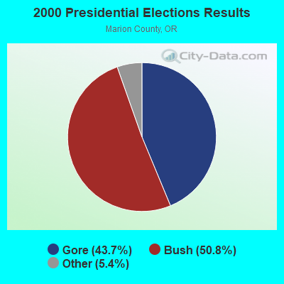
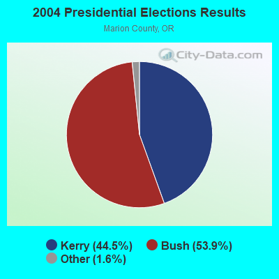
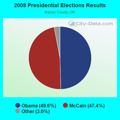
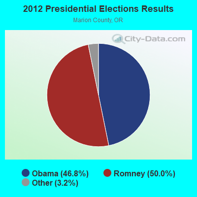
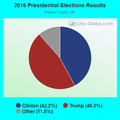
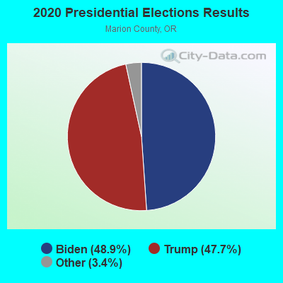
Graphs represent county-level data. Detailed 2008 Election Results
Religion statistics for Mount Angel, OR (based on Marion County data)
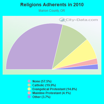
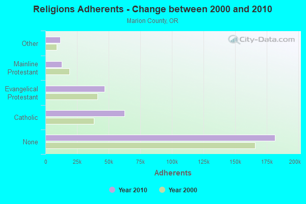
| Religion | Adherents | Congregations |
|---|---|---|
| Catholic | 62,607 | 15 |
| Evangelical Protestant | 46,619 | 186 |
| Mainline Protestant | 12,797 | 41 |
| Other | 11,663 | 46 |
| Black Protestant | 189 | 1 |
| Orthodox | - | - |
| None | 181,460 | - |
Food Environment Statistics:
| Marion County: | 1.71 / 10,000 pop. |
| State: | 2.03 / 10,000 pop. |
| This county: | 0.29 / 10,000 pop. |
| Oregon: | 0.33 / 10,000 pop. |
| This county: | 1.61 / 10,000 pop. |
| Oregon: | 2.01 / 10,000 pop. |
| Marion County: | 1.52 / 10,000 pop. |
| Oregon: | 1.69 / 10,000 pop. |
| This county: | 6.68 / 10,000 pop. |
| Oregon: | 9.93 / 10,000 pop. |
| This county: | 8.2% |
| Oregon: | 7.4% |
| Here: | 29.5% |
| Oregon: | 25.6% |
| Marion County: | 18.4% |
| State: | 14.2% |
Health and Nutrition:
| This city: | 46.8% |
| Oregon: | 49.6% |
| Mount Angel: | 43.9% |
| Oregon: | 46.8% |
| This city: | 28.4 |
| Oregon: | 28.5 |
| Here: | 25.1% |
| Oregon: | 21.2% |
| Here: | 11.2% |
| Oregon: | 10.1% |
| Mount Angel: | 6.8 |
| Oregon: | 6.8 |
| Mount Angel: | 33.2% |
| Oregon: | 33.3% |
| Mount Angel: | 52.2% |
| State: | 56.5% |
| Mount Angel: | 77.2% |
| Oregon: | 78.7% |
More about Health and Nutrition of Mount Angel, OR Residents
| Local government employment and payroll (March 2022) | |||||
| Function | Full-time employees | Monthly full-time payroll | Average yearly full-time wage | Part-time employees | Monthly part-time payroll |
|---|---|---|---|---|---|
| Police Protection - Officers | 7 | $43,074 | $73,841 | 0 | $0 |
| Water Supply | 2 | $10,038 | $60,228 | 0 | $0 |
| Sewerage | 1 | $4,900 | $58,800 | 0 | $0 |
| Financial Administration | 1 | $8,543 | $102,516 | 3 | $8,616 |
| Other Government Administration | 1 | $11,776 | $141,312 | 0 | $0 |
| Streets and Highways | 1 | $4,046 | $48,552 | 0 | $0 |
| Parks and Recreation | 1 | $2,820 | $33,840 | 0 | $0 |
| Police - Other | 0 | $0 | 2 | $3,760 | |
| Local Libraries | 0 | $0 | 3 | $8,452 | |
| Totals for Government | 14 | $85,196 | $73,025 | 8 | $20,828 |
Mount Angel government finances - Expenditure in 2021 (per resident):
- Construction - Sewerage: $240,000 ($70.59)
Water Utilities: $75,000 ($22.06)
Regular Highways: $66,000 ($19.41)
General - Other: $41,000 ($12.06)
Parks and Recreation: $3,000 ($0.88)
Local Fire Protection: $2,000 ($0.59)
- Current Operations - Sewerage: $517,000 ($152.06)
Water Utilities: $476,000 ($140.00)
Police Protection: $471,000 ($138.53)
Regular Highways: $452,000 ($132.94)
Parks and Recreation: $269,000 ($79.12)
Libraries: $166,000 ($48.82)
Financial Administration: $159,000 ($46.76)
Protective Inspection and Regulation - Other: $128,000 ($37.65)
General - Other: $122,000 ($35.88)
Housing and Community Development: $59,000 ($17.35)
Central Staff Services: $48,000 ($14.12)
General Public Buildings: $14,000 ($4.12)
Judicial and Legal Services: $11,000 ($3.24)
Solid Waste Management: $10,000 ($2.94)
Health - Other: $7,000 ($2.06)
- General - Interest on Debt: $38,000 ($11.18)
- Intergovernmental to State - Judicial and Legal Services: $87,000 ($25.59)
- Other Capital Outlay - Sewerage: $133,000 ($39.12)
Local Fire Protection: $28,000 ($8.24)
General - Other: $15,000 ($4.41)
Police Protection: $9,000 ($2.65)
Parks and Recreation: $7,000 ($2.06)
- Total Salaries and Wages: $2,705,000 ($795.59)
Mount Angel government finances - Revenue in 2021 (per resident):
- Charges - Sewerage: $866,000 ($254.71)
Other: $429,000 ($126.18)
Parks and Recreation: $68,000 ($20.00)
- Local Intergovernmental - Highways: $265,000 ($77.94)
Other: $88,000 ($25.88)
General Local Government Support: $32,000 ($9.41)
- Miscellaneous - Interest Earnings: $134,000 ($39.41)
Fines and Forfeits: $19,000 ($5.59)
General Revenue - Other: $16,000 ($4.71)
Donations From Private Sources: $9,000 ($2.65)
Special Assessments: $9,000 ($2.65)
Rents: $3,000 ($0.88)
Sale of Property: $3,000 ($0.88)
- Revenue - Water Utilities: $491,000 ($144.41)
- State Intergovernmental - General Local Government Support: $117,000 ($34.41)
Other: $27,000 ($7.94)
Water Utilities: $4,000 ($1.18)
- Tax - Property: $1,606,000 ($472.35)
Public Utilities Sales: $457,000 ($134.41)
Other License: $215,000 ($63.24)
Mount Angel government finances - Debt in 2021 (per resident):
- Long Term Debt - Beginning Outstanding - Unspecified Public Purpose: $964,000 ($283.53)
Outstanding Unspecified Public Purpose: $840,000 ($247.06)
Retired Unspecified Public Purpose: $124,000 ($36.47)
Mount Angel government finances - Cash and Securities in 2021 (per resident):
- Other Funds - Cash and Securities: $7,055,000 ($2075.00)
- Sinking Funds - Cash and Securities: $110,000 ($32.35)
Businesses in Mount Angel, OR
- True Value: 1
Strongest AM radio stations in Mount Angel:
- KPOJ (620 AM; 50 kW; PORTLAND, OR; Owner: CITICASTERS LICENSES, L.P.)
- KXL (750 AM; 50 kW; PORTLAND, OR; Owner: ROSE CITY RADIO CORPORATION)
- KEX (1190 AM; 50 kW; PORTLAND, OR; Owner: CITICASTERS LICENSES, L.P.)
- KKSN (1520 AM; 50 kW; OREGON CITY, OR; Owner: ENTERCOM PORTLAND LICENSE, LLC)
- KSLM (1390 AM; 10 kW; SALEM, OR)
- KOTK (1080 AM; 50 kW; PORTLAND, OR; Owner: FISHER BROADCASTING - PORTLAND RADIO, L.L.C.)
- KPAM (860 AM; 50 kW; TROUTDALE, OR; Owner: PAMPLIN BROADCASTING-OREGON, INC.)
- KYKN (1430 AM; 5 kW; KEIZER, OR; Owner: WILLAMETTE BROADCASTING CO., INC.)
- KKAD (1550 AM; 50 kW; VANCOUVER, WA; Owner: PAMPLIN BROADCASTING-WASHINGTON, INC)
- KKSL (1290 AM; 10 kW; LAKE OSWEGO, OR; Owner: ABC, INC.)
- KWIP (880 AM; 5 kW; DALLAS, OR; Owner: JUPITER COMMUNICATIONS CORPORATION)
- KFXX (910 AM; 10 kW; VANCOUVER, WA; Owner: ENTERCOM PORTLAND LICENSE, LLC (DE))
- KPNW (1120 AM; 50 kW; EUGENE, OR; Owner: CAPSTAR TX LIMITED PARTNERSHIP)
Strongest FM radio stations in Mount Angel:
- KRSK (105.1 FM; MOLALLA, OR; Owner: ENTERCOM PORTLAND LICENSE, LLC)
- K273AJ (102.5 FM; ELWOOD, OR; Owner: CALVARY CHAPEL OF TWIN FALLS, INC.)
- K225AI (92.9 FM; PORTLAND, OR; Owner: EDUCATIONAL MEDIA FOUNDATION)
- KLVU (107.1 FM; SWEET HOME, OR; Owner: EDUCATIONAL MEDIA FOUNDATION)
- KINK (101.9 FM; PORTLAND, OR; Owner: INFINITY RADIO OPERATIONS INC.)
- KKCW (103.3 FM; BEAVERTON, OR; Owner: CITICASTERS LICENSES, L.P.)
- KPDQ-FM (93.7 FM; PORTLAND, OR; Owner: SALEM MEDIA OF OREGON, INC.)
- KOPB-FM (91.5 FM; PORTLAND, OR; Owner: OREGON PUBLIC BROADCASTING)
- KKRZ (100.3 FM; PORTLAND, OR; Owner: CITICASTERS LICENSES, L.P.)
- KMHD (89.1 FM; GRESHAM, OR; Owner: MT. HOOD COMMUNITY COLLEGE DISTRICT)
- KVMX (107.5 FM; BANKS, OR; Owner: INFINITY RADIO OPERATIONS INC.)
- KUFO-FM (101.1 FM; PORTLAND, OR; Owner: INFINITY RADIO OPERATIONS INC.)
- KLTH (106.7 FM; LAKE OSWEGO, OR; Owner: INIFINITY RADIO OF PORTLAND INC.)
- KUPL-FM (98.7 FM; PORTLAND, OR; Owner: INFINITY RADIO OF PORTLAND INC.)
- KNRK (94.7 FM; CAMAS, WA; Owner: ENTERCOM PORTLAND LICENSE, LLC (DE))
- KBVM (88.3 FM; PORTLAND, OR; Owner: CATHOLIC BROADCASTING NORTHWEST, INC)
- KGON (92.3 FM; PORTLAND, OR; Owner: ENTERCOM PORTLAND LICENSE, LLC (DE))
- KKSN-FM (97.1 FM; PORTLAND, OR; Owner: ENTERCOM PORTLAND LICENSE, LLC (DE))
- KXJM (95.5 FM; PORTLAND, OR; Owner: ROSE CITY RADIO CORPORATION)
- KBPS-FM (89.9 FM; PORTLAND, OR; Owner: SCHOOL DISTRICT #1, MULTNOMAH COUNTY, OR)
TV broadcast stations around Mount Angel:
- KPXG (Channel 22; SALEM, OR; Owner: PAXSON SALEM LICENSE, INC.)
- KWBP (Channel 32; SALEM, OR; Owner: TRIBUNE BROADCAST HOLDINGS, INC.)
- KATU (Channel 2; PORTLAND, OR; Owner: FISHER BROADCASTING - PORTLAND TV, L.L.C.)
- KPDX (Channel 49; VANCOUVER, WA; Owner: MEREDITH CORPORATION)
- KPTV (Channel 12; PORTLAND, OR; Owner: MEREDITH CORPORATION)
- K57IF (Channel 57; SALEM, OR; Owner: LaGRANDE BROADCASTING, INC.)
- KOIN (Channel 6; PORTLAND, OR; Owner: EMMIS TELEVISION LICENSE CORPORATION)
- KNMT (Channel 24; PORTLAND, OR; Owner: NATIONAL MINORITY T.V., INC.)
- KGW (Channel 8; PORTLAND, OR; Owner: KING BROADCASTING COMPANY)
- KOPB-TV (Channel 10; PORTLAND, OR; Owner: OREGON PUBLIC BROADCASTING)
- KWBP-LP (Channel 4; PORTLAND, OR; Owner: TRIBUNE BROADCASTING HOLDINGS, INC.)
- K18EL (Channel 18; NEWBERG/TIGARD, OR; Owner: MEREDITH CORPORATION)
- KPXG-LP (Channel 54; PORTLAND, OR; Owner: PAXSON COMMUNICATIONS LICENSE COMPANY, LLC)
- K14HN (Channel 14; VANCOUVER/CAMAS, WA; Owner: MEREDITH CORPORATION)
- K61CC (Channel 61; SALEM, OR; Owner: NORTHWEST CHRISTIAN BROADCASTING)
- K50GG (Channel 50; SALEM, OR; Owner: MEREDITH CORPORATION)

Mount Angel fatal accident list:
- National Bridge Inventory (NBI) Statistics
- 14Number of bridges
- 141ft / 42.9mTotal length
- $1,178,000Total costs
- 43,353Total average daily traffic
- 3,716Total average daily truck traffic
- 57,441Total future (year 2025) average daily traffic

- New bridges - historical statistics
- 21920-1929
- 91960-1969
- 11970-1979
- 22000-2009
FCC Registered Antenna Towers:
3- Richard Byrne, 8535 S. Drake (Lat: 45.073389 Lon: -122.691417), Type: 57.9, Overall height: 54.9 m, Registrant: Towerco Assets LLC, Afry@towerco.Com, , Cary, Phone: (919) 653-5710
- Richard Byrne, 8535 S. Drake (Lat: 45.073389 Lon: -122.691417), Type: 57.9, Overall height: 54.9 m, Registrant: Towerco Assets LLC, Afry@towerco.Com, , Cary, Phone: (919) 653-5710
- Edward G Roach, 8535 S. Drake (Lat: 45.073389 Lon: -122.691417), Type: 57.9, Structure height: 41005 m, Overall height: 54.9 m, Registrant: Sba 2012 Tc Assets, LLC, Eroach@sbasite.Com, , Boca -Raton, Phone: (561) 995-7670
FCC Registered Broadcast Land Mobile Towers:
1- Mt Angel Fire Dist., Lat: 45.068056 Lon: -122.800000, Call Sign: WRDE230,
Assigned Frequencies: 173.287 MHz, 173.287 MHz, Grant Date: 04/05/2019, Expiration Date: 04/05/2029, Certifier: James P Trierweiler, Registrant: Mt Angel Fire District, 300 Monroe St, Mt Angel, OR 97362, Phone: (503) 845-2438, Fax: (503) 845-2855, Email:
FCC Registered Microwave Towers:
3- ZOLLMER, 200 Industrial Way (Lat: 45.076083 Lon: -122.799250), Type: Pole, Structure height: 40.8 m, Overall height: 42.6 m, Call Sign: WQNX605,
Assigned Frequencies: 10795.0 MHz, Grant Date: 05/25/2021, Expiration Date: 06/28/2031, Certifier: Gregory M Romano, Registrant: Verizon Wireless, 5055 North Point Pkwy, Np2ne Network Engineering, Alpharetta, GA 30022, Phone: (770) 797-1070, Email:
- PO72XC032, 8535 S. Drake (Lat: 45.073389 Lon: -122.691417), Type: Mtower, Structure height: 54.9 m, Overall height: 57.9 m, Call Sign: WQRB849, Licensee ID: L01744207,
Assigned Frequencies: 21925.0 MHz, 21875.0 MHz, 21925.0 MHz, 21875.0 MHz, 21925.0 MHz, 21875.0 MHz, 21925.0 MHz, 21875.0 MHz, 21925.0 MHz, 21875.0 MHz... (+5 more), Grant Date: 04/11/2013, Expiration Date: 04/11/2023, Cancellation Date: 11/09/2022, Certifier: David Werblow, Registrant: Sprint Spectrum LLC
- MT ANGEL, 12224 Mount Angel-Gervai Road Northeast (Lat: 45.083056 Lon: -122.815056), Type: Mtower, Structure height: 45.4 m, Overall height: 50 m, Call Sign: WQRH986,
Assigned Frequencies: 11095.0 MHz, 11175.0 MHz, Grant Date: 04/11/2023, Expiration Date: 05/16/2033, Cancellation Date: 02/29/2024, Certifier: John Monday, Registrant: At&t Services, Inc., 208 S Akard St, 20f, Dallas, TX 75202, Phone: (855) 699-7073, Email:
FCC Registered Amateur Radio Licenses:
27 (See the full list of FCC Registered Amateur Radio Licenses in Mount Angel)FAA Registered Aircraft:
2- Aircraft: CESSNA 182Q (Category: Land, Seats: 4, Weight: Up to 12,499 Pounds, Speed: 112 mph), Engine: CONT MOTOR O-470 SERIES (230 HP) (Reciprocating)
N-Number: 735SE, N735SE, N-735SE, Serial Number: 18265641, Year manufactured: 1977, Airworthiness Date: 04/23/1977, Certificate Issue Date: 04/25/1998
Registrant (LLC): Charter Pacific Leasing Co LLC, 590 Taylor St, Mount Angel, OR 97362 - Aircraft: CESSNA 182E (Category: Land, Seats: 4, Weight: Up to 12,499 Pounds, Speed: 119 mph), Engine: CONT MOTOR O-470 SERIES (230 HP) (Reciprocating)
N-Number: 3521Y, N3521Y, N-3521Y, Serial Number: 18254421, Year manufactured: 1962, Airworthiness Date: 09/26/1962, Certificate Issue Date: 05/02/2001
Registrant (Co-Owned): John W Finklea, Po Box 365, Mount Angel, OR 97362, Other Owners: Catherine A Cheney
Deregistered: Cancel Date: 10/26/2017
| Home Mortgage Disclosure Act Aggregated Statistics For Year 2009 (Based on 1 partial tract) | ||
| C) Refinancings | ||
|---|---|---|
| Number | Average Value | |
| LOANS ORIGINATED | 2 | $153,760 |
| APPLICATIONS APPROVED, NOT ACCEPTED | 0 | $0 |
| APPLICATIONS DENIED | 1 | $176,990 |
| APPLICATIONS WITHDRAWN | 1 | $105,730 |
| FILES CLOSED FOR INCOMPLETENESS | 0 | $0 |
Detailed HMDA statistics for the following Tracts: 0104.00
| Private Mortgage Insurance Companies Aggregated Statistics For Year 2007 (Based on 1 partial tract) | ||
| A) Conventional Home Purchase Loans | ||
|---|---|---|
| Number | Average Value | |
| LOANS ORIGINATED | 1 | $138,790 |
| APPLICATIONS APPROVED, NOT ACCEPTED | 0 | $0 |
| APPLICATIONS DENIED | 0 | $0 |
| APPLICATIONS WITHDRAWN | 0 | $0 |
| FILES CLOSED FOR INCOMPLETENESS | 0 | $0 |
Detailed PMIC statistics for the following Tracts: 0104.00


2003 - 2018 National Fire Incident Reporting System (NFIRS) incidents
- Fire incident types reported to NFIRS in Mount Angel, OR
- 6739.4%Outside Fires
- 6035.3%Structure Fires
- 3218.8%Mobile Property/Vehicle Fires
- 116.5%Other
 Based on the data from the years 2003 - 2018 the average number of fires per year is 11. The highest number of fire incidents - 22 took place in 2015, and the least - 0 in 2007. The data has a dropping trend.
 When looking into fire subcategories, the most reports belonged to: Outside Fires (39.4%), and Structure Fires (35.3%).
| Most common first names in Mount Angel, OR among deceased individuals | ||
| Name | Count | Lived (average) |
|---|---|---|
| Mary | 54 | 84.6 years |
| John | 41 | 79.5 years |
| Joseph | 34 | 80.1 years |
| Anna | 29 | 84.7 years |
| William | 23 | 82.6 years |
| Robert | 21 | 75.1 years |
| Charles | 21 | 75.1 years |
| Helen | 20 | 86.6 years |
| Margaret | 20 | 83.4 years |
| Albert | 19 | 80.1 years |
| Most common last names in Mount Angel, OR among deceased individuals | ||
| Last name | Count | Lived (average) |
|---|---|---|
| Schmidt | 17 | 81.8 years |
| Johnson | 14 | 80.0 years |
| Duda | 12 | 75.7 years |
| Smith | 11 | 79.2 years |
| Annen | 11 | 77.1 years |
| Berning | 10 | 78.1 years |
| Ebner | 9 | 80.5 years |
| Anderson | 8 | 83.5 years |
| Meissner | 8 | 75.0 years |
| Brown | 8 | 75.4 years |

- 55.8%Utility gas
- 43.4%Electricity
- 0.8%Fuel oil, kerosene, etc.

- 79.8%Electricity
- 15.8%Utility gas
- 3.0%Bottled, tank, or LP gas
- 1.4%Other fuel
Mount Angel compared to Oregon state average:
- Unemployed percentage below state average.
- Black race population percentage significantly below state average.
- Hispanic race population percentage significantly above state average.
- Length of stay since moving in significantly above state average.
- Institutionalized population percentage above state average.
Mount Angel on our top lists:
- #77 on the list of "Top 101 cities with the largest percentage of people in religious group quarters (population 1,000+)"
- #89 on the list of "Top 101 cities with the largest percentage of people in other noninstitutional group quarters (population 1,000+)"
- #26 on the list of "Top 101 counties with the lowest percentage of residents relocating from foreign countries between 2010 and 2011"
- #40 on the list of "Top 101 counties with the lowest percentage of residents relocating to foreign countries in 2011"
- #66 on the list of "Top 101 counties with the lowest Ozone (1-hour) air pollution readings in 2012 (ppm)"
- #67 on the list of "Top 101 counties with the highest percentage of residents that drank alcohol in the past 30 days"
- #74 on the list of "Top 101 counties with the highest surface withdrawal of fresh water for public supply (pop. 50,000+)"

|
Total of 1 patent application in 2008-2024.