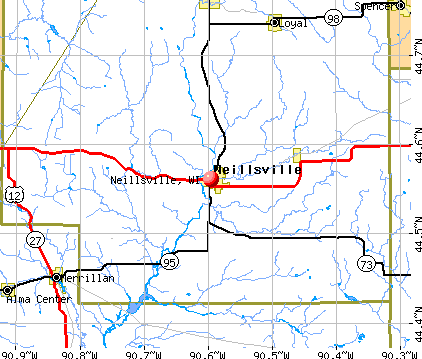
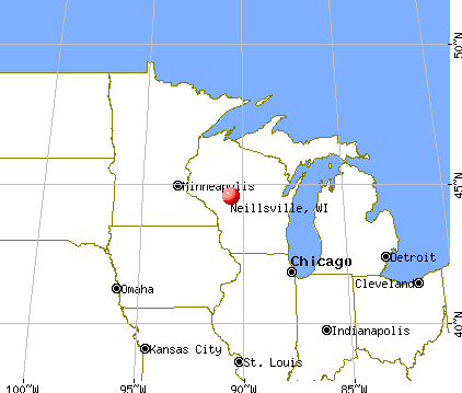
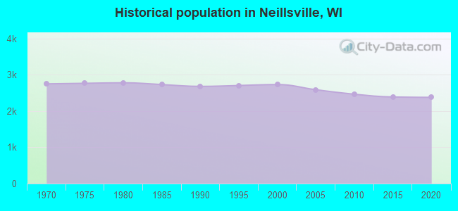
Neillsville, Wisconsin

Neillsville: WW-II Memorial Picture 4 - High Ground West of Neillsville

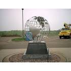
Neillsville: A War Memorial Honoring The National Native Indians Who Served Our Country Located At The High Ground West of Neillsville

Neillsville: A War Memorial Located At The High Ground West of Neillsville
Neillsville: WW-II Memorial Picture 2 - High Ground West of Neillsville
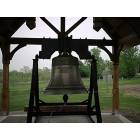
Neillsville: A Liberty Bell Replica Located At The High Ground West of Neillsville
Neillsville: A War Memorial Honoring The Women Of Wisconsin Who Served Our Country Located At The High Ground West of Neillsville
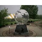
Neillsville: WW-II Memorial Picture 1 - High Ground West of Neillsville

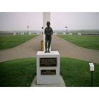
Neillsville: A World War-I Memorial (Note Star in Background) Located At The High Ground West of Neillsville
- add
your


Submit your own pictures of this city and show them to the world
- OSM Map
- General Map
- Google Map
- MSN Map
Population change since 2000: -15.2%
 |
| Males: 1,175 | |
| Females: 1,142 |
| Median resident age: | 40.8 years |
| Wisconsin median age: | 40.4 years |
Zip codes: 54456.
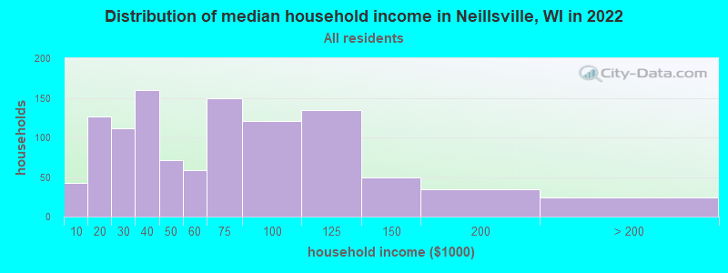
| Neillsville: | $56,242 |
| WI: | $70,996 |
Estimated per capita income in 2022: $31,410 (it was $16,298 in 2000)
Neillsville city income, earnings, and wages data
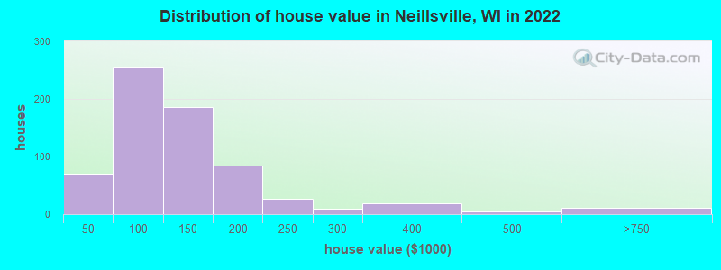
Estimated median house or condo value in 2022: $112,416 (it was $59,000 in 2000)
| Neillsville: | $112,416 |
| WI: | $252,800 |
Mean prices in 2022: all housing units: $219,245; detached houses: $223,709; townhouses or other attached units: $302,988; in 2-unit structures: $128,535; in 3-to-4-unit structures: $94,848; in 5-or-more-unit structures: $472,971; mobile homes: $106,493; occupied boats, rvs, vans, etc.: over $1,000,000
Median gross rent in 2022: $659.
(11.5% for White Non-Hispanic residents, 33.3% for Black residents, 12.5% for Hispanic or Latino residents, 33.3% for two or more races residents)
Detailed information about poverty and poor residents in Neillsville, WI

Compare current foreclosures near Neillsville, WI:
| Photo | Address | Area | Beds / Baths | Price | Details |
|---|---|---|---|---|---|

|
#1
Us Highway 10, Lot 6
Neillsville, WI 54456
|
- sq. feet
|
- baths - beds |
show details | |

|
#2
State Highway 95
Neillsville, WI 54456
|
- sq. feet
|
- baths - beds |
show details | |

|
#3
W 7th St
Neillsville, WI 54456
|
- sq. feet
|
- baths - beds |
show details | |

|
#4
Division Ave
Spencer, WI 54479
|
- sq. feet
|
3 baths 4 beds |
show details | |

|
#5
County Road K
Granton, WI 54436
|
- sq. feet
|
- baths - beds |
show details | |

|
#6
Pelsdorf Ave
Granton, WI 54436
|
- sq. feet
|
- baths - beds |
show details | |

|
#7
N Eaton Ave
Greenwood, WI 54437
|
- sq. feet
|
- baths - beds |
show details | |

|
#8
Sand Rd
Merrillan, WI 54754
|
- sq. feet
|
- baths - beds |
show details | |

|
#9
Pelsdorf Ave
Loyal, WI 54446
|
- sq. feet
|
- baths - beds |
show details | |

|
#10
W Begley St
Greenwood, WI 54437
|
- sq. feet
|
- baths - beds |
show details |
| Photo | Address | Area | Beds / Baths | Price | Details |
|---|---|---|---|---|---|

|
#11
Lindsey Rd
Marshfield, WI 54449
|
- sq. feet
|
- baths - beds |
show details | |

|
Check over 1 million property listings on Foreclosure.com!
|
browse all offers | |||


- 2,12291.7%White alone
- 893.8%Two or more races
- 331.4%Other race alone
- 331.4%Hispanic
- 251.1%Black alone
- 70.3%American Indian alone
- 50.2%Asian alone
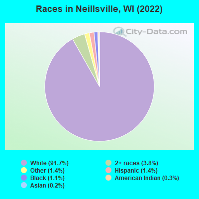
Races in Neillsville detailed stats: ancestries, foreign born residents, place of birth
According to our research of Wisconsin and other state lists, there were 29 registered sex offenders living in Neillsville, Wisconsin as of April 23, 2024.
The ratio of all residents to sex offenders in Neillsville is 78 to 1.
Type |
2009 |
2010 |
2011 |
2012 |
2013 |
2014 |
2015 |
2016 |
2017 |
2018 |
2019 |
2020 |
|---|---|---|---|---|---|---|---|---|---|---|---|---|
| Murders (per 100,000) | 1 (38.8) | 0 (0.0) | 0 (0.0) | 0 (0.0) | 0 (0.0) | 0 (0.0) | 0 (0.0) | 0 (0.0) | 0 (0.0) | 0 (0.0) | 0 (0.0) | 0 (0.0) |
| Rapes (per 100,000) | 0 (0.0) | 0 (0.0) | 0 (0.0) | 0 (0.0) | 0 (0.0) | 0 (0.0) | 0 (0.0) | 0 (0.0) | 1 (41.2) | 1 (41.5) | 0 (0.0) | 1 (41.6) |
| Robberies (per 100,000) | 0 (0.0) | 0 (0.0) | 0 (0.0) | 0 (0.0) | 0 (0.0) | 0 (0.0) | 0 (0.0) | 0 (0.0) | 0 (0.0) | 0 (0.0) | 0 (0.0) | 0 (0.0) |
| Assaults (per 100,000) | 0 (0.0) | 1 (40.6) | 0 (0.0) | 1 (40.4) | 0 (0.0) | 1 (41.0) | 0 (0.0) | 0 (0.0) | 0 (0.0) | 1 (41.5) | 1 (41.9) | 1 (41.6) |
| Burglaries (per 100,000) | 31 (1,203) | 11 (446.6) | 15 (606.3) | 5 (202.2) | 3 (124.4) | 0 (0.0) | 3 (124.6) | 1 (41.7) | 3 (123.7) | 3 (124.5) | 3 (125.6) | 1 (41.6) |
| Thefts (per 100,000) | 83 (3,222) | 70 (2,842) | 66 (2,668) | 37 (1,496) | 40 (1,659) | 36 (1,477) | 43 (1,786) | 36 (1,501) | 35 (1,443) | 26 (1,079) | 24 (1,005) | 13 (541.0) |
| Auto thefts (per 100,000) | 0 (0.0) | 1 (40.6) | 1 (40.4) | 0 (0.0) | 0 (0.0) | 0 (0.0) | 3 (124.6) | 1 (41.7) | 2 (82.5) | 6 (249.0) | 0 (0.0) | 8 (332.9) |
| Arson (per 100,000) | 0 (0.0) | 1 (40.6) | 0 (0.0) | 0 (0.0) | 0 (0.0) | 0 (0.0) | 0 (0.0) | 0 (0.0) | 0 (0.0) | 0 (0.0) | 0 (0.0) | 0 (0.0) |
| City-Data.com crime index | 290.8 | 156.3 | 152.4 | 82.1 | 75.1 | 67.3 | 90.1 | 66.3 | 106.0 | 113.3 | 57.4 | 92.8 |
The City-Data.com crime index weighs serious crimes and violent crimes more heavily. Higher means more crime, U.S. average is 246.1. It adjusts for the number of visitors and daily workers commuting into cities.
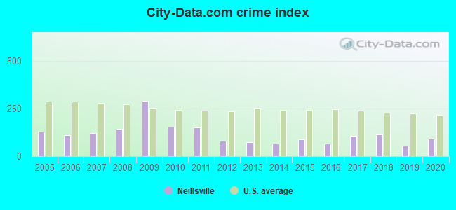
Crime rate in Neillsville detailed stats: murders, rapes, robberies, assaults, burglaries, thefts, arson
Full-time law enforcement employees in 2021, including police officers: 7 (6 officers - 6 male; 0 female).
| Officers per 1,000 residents here: | 2.53 |
| Wisconsin average: | 2.07 |
 Recent articles from our blog. Our writers, many of them Ph.D. graduates or candidates, create easy-to-read articles on a wide variety of topics.


Latest news from Neillsville, WI collected exclusively by city-data.com from local newspapers, TV, and radio stations
Ancestries: German (50.2%), American (11.1%), Polish (5.3%), Irish (2.9%), Norwegian (2.6%), Slovene (2.4%).
Current Local Time: CST time zone
Incorporated in 1882
Elevation: 1030 feet
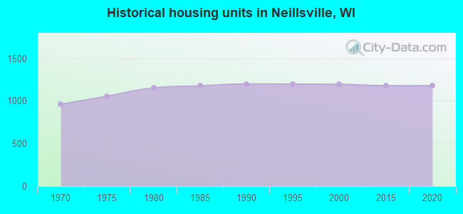
Land area: 2.80 square miles.
Population density: 827 people per square mile (low).
23 residents are foreign born
| This city: | 1.0% |
| Wisconsin: | 5.0% |
Median real estate property taxes paid for housing units with mortgages in 2022: $1,812 (1.6%)
Median real estate property taxes paid for housing units with no mortgage in 2022: $1,896 (1.7%)
Nearest city with pop. 50,000+: Eau Claire, WI  (47.5 miles , pop. 61,704).
Nearest city with pop. 200,000+: Madison, WI (119.0 miles , pop. 208,054).
Nearest city with pop. 1,000,000+: Chicago, IL (238.8 miles , pop. 2,896,016).
Nearest cities:
), ), ), ), ), ), )Latitude: 44.56 N, Longitude: 90.60 W
Area code: 715
Neillsville, Wisconsin accommodation & food services, waste management - Economy and Business Data
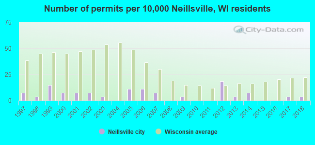
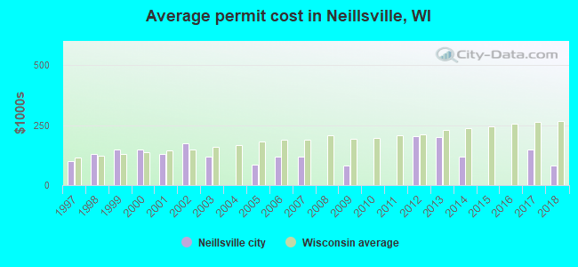
Single-family new house construction building permits:
- 2018: 1 building, cost: $80,000
- 2017: 1 building, cost: $150,000
- 2014: 2 buildings, average cost: $120,000
- 2013: 1 building, cost: $200,000
- 2012: 5 buildings, average cost: $204,000
- 2009: 1 building, cost: $80,000
- 2007: 2 buildings, average cost: $117,500
- 2006: 3 buildings, average cost: $116,700
- 2005: 3 buildings, average cost: $86,700
- 2003: 1 building, cost: $120,000
- 2002: 2 buildings, average cost: $175,000
- 2001: 2 buildings, average cost: $130,000
- 2000: 2 buildings, average cost: $150,000
- 1999: 4 buildings, average cost: $150,000
- 1998: 1 building, cost: $130,000
- 1997: 2 buildings, average cost: $100,000
| Here: | 2.8% |
| Wisconsin: | 2.7% |
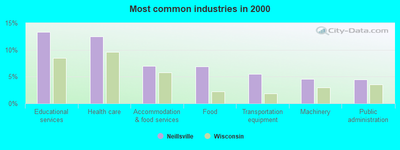
- Educational services (13.4%)
- Health care (12.5%)
- Accommodation & food services (7.0%)
- Food (6.9%)
- Transportation equipment (5.5%)
- Machinery (4.6%)
- Public administration (4.5%)
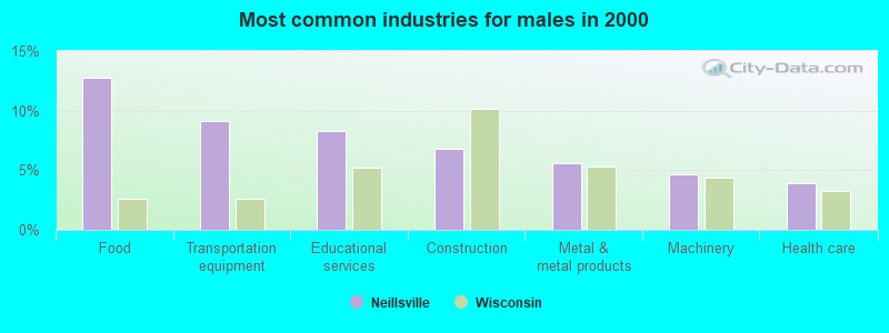
- Food (12.7%)
- Transportation equipment (9.2%)
- Educational services (8.3%)
- Construction (6.8%)
- Metal & metal products (5.6%)
- Machinery (4.7%)
- Health care (3.9%)
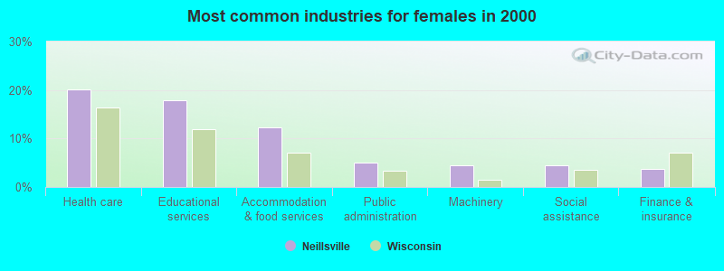
- Health care (20.1%)
- Educational services (17.9%)
- Accommodation & food services (12.3%)
- Public administration (5.1%)
- Machinery (4.5%)
- Social assistance (4.5%)
- Finance & insurance (3.7%)
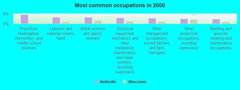
- Preschool, kindergarten, elementary, and middle school teachers (7.5%)
- Laborers and material movers, hand (5.4%)
- Metal workers and plastic workers (5.2%)
- Electrical equipment mechanics and other installation, maintenance, and repair workers, including supervisors (4.9%)
- Other management occupations, except farmers and farm managers (4.6%)
- Other production occupations, including supervisors (4.1%)
- Building and grounds cleaning and maintenance occupations (4.0%)
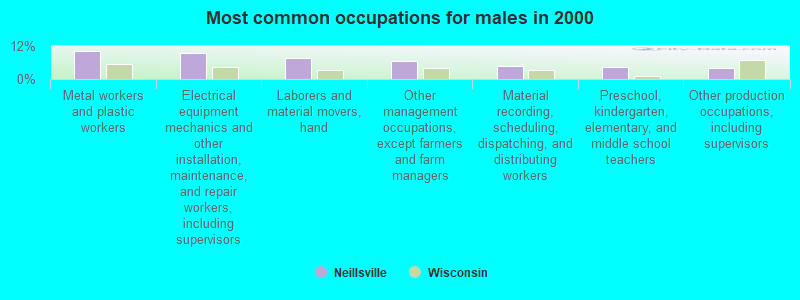
- Metal workers and plastic workers (10.2%)
- Electrical equipment mechanics and other installation, maintenance, and repair workers, including supervisors (9.3%)
- Laborers and material movers, hand (7.7%)
- Other management occupations, except farmers and farm managers (6.6%)
- Material recording, scheduling, dispatching, and distributing workers (4.7%)
- Preschool, kindergarten, elementary, and middle school teachers (4.5%)
- Other production occupations, including supervisors (4.1%)

- Preschool, kindergarten, elementary, and middle school teachers (10.2%)
- Cooks and food preparation workers (5.0%)
- Assemblers and fabricators (4.8%)
- Nursing, psychiatric, and home health aides (4.6%)
- Other office and administrative support workers, including supervisors (4.2%)
- Secretaries and administrative assistants (4.2%)
- Other food preparation and serving workers, including supervisors (4.2%)
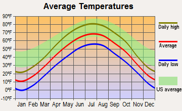
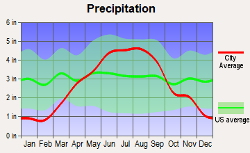
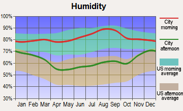
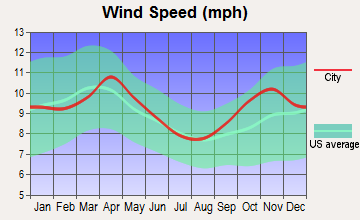
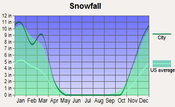
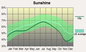
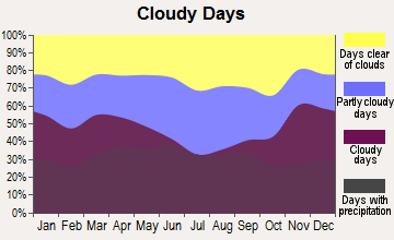
Average climate in Neillsville, Wisconsin
Based on data reported by over 4,000 weather stations
|
|


(lower is better)
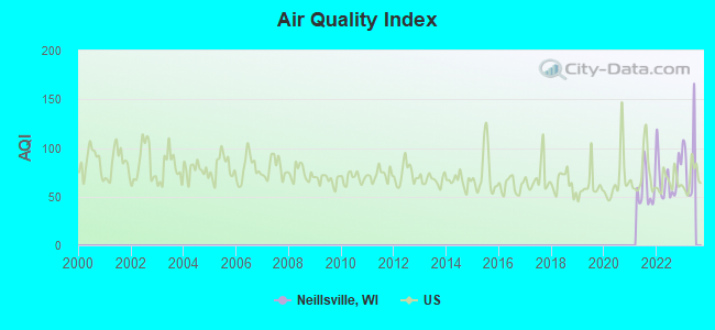
Air Quality Index (AQI) level in 2022 was 69.9. This is about average.
| City: | 69.9 |
| U.S.: | 72.6 |

Particulate Matter (PM2.5) [µg/m3] level in 2022 was 6.34. This is better than average. Closest monitor was 18.4 miles away from the city center.
| City: | 6.34 |
| U.S.: | 8.11 |
Tornado activity:
Neillsville-area historical tornado activity is near Wisconsin state average. It is 8% greater than the overall U.S. average.
On 6/4/1958, a category F4 (max. wind speeds 207-260 mph) tornado 34.9 miles away from the Neillsville city center killed 4 people and injured 3 people and caused between $500,000 and $5,000,000 in damages.
On 5/26/1959, a category F3 (max. wind speeds 158-206 mph) tornado 15.3 miles away from the city center injured 2 people and caused between $50,000 and $500,000 in damages.
Earthquake activity:
Neillsville-area historical earthquake activity is significantly above Wisconsin state average. It is 14% greater than the overall U.S. average.On 7/9/1975 at 14:54:15, a magnitude 4.6 (4.6 MB, Class: Light, Intensity: IV - V) earthquake occurred 276.5 miles away from Neillsville center
On 6/28/2004 at 06:10:52, a magnitude 4.2 (4.2 MW, Depth: 6.2 mi) earthquake occurred 231.0 miles away from Neillsville center
On 4/18/2008 at 09:36:59, a magnitude 5.4 (5.1 MB, 4.8 MS, 5.4 MW, 5.2 MW, Class: Moderate, Intensity: VI - VII) earthquake occurred 445.2 miles away from the city center
On 6/10/1987 at 23:48:54, a magnitude 5.1 (4.9 MB, 4.4 MS, 4.6 MS, 5.1 LG) earthquake occurred 420.9 miles away from Neillsville center
On 2/10/2010 at 09:59:35, a magnitude 3.8 (3.8 MW, Depth: 6.2 mi, Class: Light, Intensity: II - III) earthquake occurred 208.1 miles away from Neillsville center
On 4/18/2008 at 09:36:59, a magnitude 5.2 (5.2 MW, Depth: 8.9 mi) earthquake occurred 445.2 miles away from Neillsville center
Magnitude types: regional Lg-wave magnitude (LG), body-wave magnitude (MB), surface-wave magnitude (MS), moment magnitude (MW)
Natural disasters:
The number of natural disasters in Clark County (14) is near the US average (15).Major Disasters (Presidential) Declared: 11
Emergencies Declared: 2
Causes of natural disasters: Floods: 11, Storms: 10, Tornadoes: 4, Winds: 3, Drought: 1, Heavy Rain: 1, Hurricane: 1, Mudslide: 1, Other: 1 (Note: some incidents may be assigned to more than one category).

Hospitals and medical centers in Neillsville:
Airports located in Neillsville:
- Neillsville Municipal Airport (VIQ) (Runways: 1, Air Taxi Ops: 500, Itinerant Ops: 3,000, Local Ops: 4,000, Military Ops: 20)
Colleges/universities with over 2000 students nearest to Neillsville:
- Mid-State Technical College (about 42 miles; Wisconsin Rapids, WI; Full-time enrollment: 2,128)
- University of Wisconsin-Eau Claire (about 48 miles; Eau Claire, WI; FT enrollment: 10,143)
- Chippewa Valley Technical College (about 48 miles; Eau Claire, WI; FT enrollment: 4,038)
- University of Wisconsin-Stevens Point (about 51 miles; Stevens Point, WI; FT enrollment: 9,089)
- Northcentral Technical College (about 55 miles; Wausau, WI; FT enrollment: 3,356)
- University of Wisconsin-La Crosse (about 61 miles; La Crosse, WI; FT enrollment: 9,837)
- Western Technical College (about 61 miles; La Crosse, WI; FT enrollment: 3,377)
Public high school in Neillsville:
- NEILLSVILLE MIDDLE/HIGH (Students: 467, Location: 401 CENTER ST, Grades: 7-12)
Public elementary/middle school in Neillsville:
Private elementary/middle school in Neillsville:
User-submitted facts and corrections:
- 92.7 FM; NEILLSVILLE, WI; Owner: CENTRAL WISCONSIN B/CG INC
Points of interest:
Notable locations in Neillsville: Neillsville Wastewater Treatment Facility (A), Neillsville Municipal Ambulance Service (B), Neillsville Area Fire Department (C). Display/hide their locations on the map
Churches in Neillsville include: Assembly of God Church (A), Bible Baptist Church (B), Calvary Lutheran Church (C), Kingdom Hall of Jehovahs Witnesses (D), Living Hope Evangelical Church (E), Saint Johns Evangelical Lutheran Church (F), Saint Marys Catholic Church (G). Display/hide their locations on the map
Cemeteries: Neillsville City Cemetery (1), Saint Marys Cemetery (2). Display/hide their locations on the map
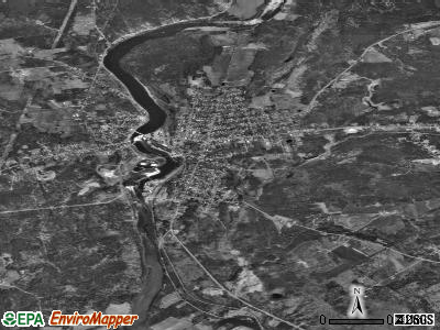
Creek: O'Neill Creek (A). Display/hide its location on the map
Parks in Neillsville include: Clark County Fairgrounds (1), Fountain Park (2), Listeman Arboretum (3), Marguerite Listeman Park (4), Northside Park (5), Schuster Park (6), Tock Memorial Field (7). Display/hide their locations on the map
Hotels: Heartland Motel (7 South Hewett Street), Fannies Motel & Supper Club (W3741 US Highway 10), Moraine Motel (W6949 Ridge Road).
Court: Clark County Government Offices - Register In Probate- County Clerk- Circuit C (517 Court Street Rm 301).
Birthplace of: Virginia Satir - Writer.
Drinking water stations with addresses in Neillsville and their reported violations in the past:
ZION LUTHERAN CHURCH-PINE VALLEY (Population served: 64, Groundwater):Past monitoring violations:GRANDVIEW MOBILE HOME COURT (Population served: 50, Groundwater):
- Monitoring, Check/Repeat/Confirmation - Between AUG-29-2006 and SEP-30-2006, Contaminant: Nitrate. Follow-up actions: St Compliance achieved (OCT-02-2006), St No addtl Formal Action needed (OCT-12-2006)
- Monitoring, Repeat Major (TCR) - Between JAN-2006 and SEP-2006, Contaminant: Coliform (TCR). Follow-up actions: St Public Notif requested (SEP-28-2006), St Violation/Reminder Notice (SEP-28-2006), St Compliance achieved (OCT-03-2006)
Past health violations:CAWLEY CREEK VILLAGE (Population served: 35, Groundwater):Past monitoring violations:
- MCL, Monthly (TCR) - In NOV-2010, Contaminant: Coliform. Follow-up actions: St Boil Water Order (DEC-09-2010), St Violation/Reminder Notice (DEC-09-2010), St Public Notif requested (DEC-09-2010), St Public Notif received (DEC-10-2010), St Compliance achieved (DEC-21-2010)
- MCL, Monthly (TCR) - In JUL-2010, Contaminant: Coliform. Follow-up actions: St Public Notif received (AUG-04-2010), St Violation/Reminder Notice (AUG-04-2010), St Boil Water Order (AUG-04-2010), St Public Notif requested (AUG-04-2010), St Compliance achieved (AUG-16-2010)
- One regular monitoring violation
Past health violations:OUTPOST CLUB (Population served: 25, Groundwater):
- MCL, Monthly (TCR) - In AUG-2013, Contaminant: Coliform. Follow-up actions: St Boil Water Order (SEP-04-2013), St Violation/Reminder Notice (SEP-04-2013), St Public Notif requested (SEP-04-2013), St Public Notif received (SEP-09-2013), St Compliance achieved (SEP-17-2013), St Public Notif received (JUN-19-2014)
Past health violations:Past monitoring violations:
- MCL, Monthly (TCR) - In MAY-2011, Contaminant: Coliform. Follow-up actions: St Boil Water Order (MAY-06-2011), St Public Notif requested (MAY-06-2011), St Violation/Reminder Notice (MAY-06-2011), St Other (MAY-31-2011), St Compliance achieved (MAY-31-2011), St Other (JUN-06-2011), St Public Notif received (NOV-10-2011)
- MCL, Monthly (TCR) - In NOV-2010, Contaminant: Coliform. Follow-up actions: St Boil Water Order (NOV-05-2010), St Violation/Reminder Notice (NOV-05-2010), St Public Notif requested (NOV-05-2010), St Public Notif received (NOV-13-2010), St Other (2 times from NOV-30-2010 to MAY-03-2011), St Compliance achieved (MAY-03-2011)
- MCL, Monthly (TCR) - In AUG-2010, Contaminant: Coliform. Follow-up actions: St Boil Water Order (AUG-19-2010), St Violation/Reminder Notice (AUG-19-2010), St Public Notif requested (AUG-19-2010), St Other (AUG-19-2010), St Public Notif received (AUG-21-2010), St Compliance achieved (SEP-13-2010)
- Monitoring, Source Water (GWR) - In MAY-2011, Contaminant: E. COLI. Follow-up actions: St Public Notif requested (MAY-23-2011), St Violation/Reminder Notice (MAY-23-2011), St Compliance achieved (MAY-23-2011), St Public Notif received (SEP-20-2011)
- Monitoring, Source Water (GWR) - In NOV-2010, Contaminant: E. COLI. Follow-up actions: St Public Notif requested (NOV-22-2010), St Violation/Reminder Notice (NOV-22-2010), St Other (3 times from NOV-30-2010 to DEC-13-2010), St Compliance achieved (DEC-22-2010)
- Monitoring, Repeat Major (TCR) - Between JAN-2009 and SEP-2009, Contaminant: Coliform (TCR). Follow-up actions: St Public Notif requested (OCT-20-2009), St Violation/Reminder Notice (OCT-20-2009), St Other (2 times from OCT-20-2009 to OCT-20-2009), St Public Notif received (OCT-28-2009), St Violation/Reminder Notice (NOV-03-2009), St Other (NOV-06-2009), St Violation/Reminder Notice (NOV-11-2009), St Other (NOV-23-2009), St Public Notif requested (FEB-09-2010), St Violation/Reminder Notice (FEB-09-2010), St Compliance achieved (AUG-18-2010)
- 5 routine major monitoring violations
- 2 regular monitoring violations
Drinking water stations with addresses in Neillsville that have no violations reported:
- ROB & HOPES LOW RIDER TAVERN (Population served: 30, Primary Water Source Type: Groundwater)
- WILDCAT INN & CAMPGROUND (Population served: 25, Primary Water Source Type: Groundwater)
| This city: | 2.1 people |
| Wisconsin: | 2.4 people |
| This city: | 53.5% |
| Whole state: | 64.4% |
| This city: | 5.7% |
| Whole state: | 7.3% |
Likely homosexual households (counted as self-reported same-sex unmarried-partner households)
- Lesbian couples: 0.4% of all households
- Gay men: 0.0% of all households
60 people in nursing facilities/skilled-nursing facilities in 2010
People in group quarters in Neillsville in 2000:
- 116 people in nursing homes
- 43 people in local jails and other confinement facilities (including police lockups)
- 42 people in other nonhousehold living situations
Banks with branches in Neillsville (2011 data):
- Associated Bank, National Association: Neillsville Branch at 509 Grand Ave, branch established on 1964/01/01. Info updated 2008/09/12: Bank assets: $21,715.0 mil, Deposits: $15,244.4 mil, headquarters in Green Bay, WI, positive income, Commercial Lending Specialization, 282 total offices, Holding Company: Associated Banc-Corp
- Citizens State Bank of Loyal: Neillsville Branch at 2 Boon Boulevard, branch established on 1995/06/12. Info updated 2006/11/03: Bank assets: $151.9 mil, Deposits: $116.5 mil, headquarters in Loyal, WI, positive income, Agricultural Specialization, 4 total offices, Holding Company: Citizens Bancshares Of Loyal, Inc.
- Mid-Wisconsin Bank: Neillsville Branch at 500 West Street, branch established on 1879/03/01. Info updated 2012/01/30: Bank assets: $484.9 mil, Deposits: $384.4 mil, headquarters in Medford, WI, negative income in the last year, Commercial Lending Specialization, 13 total offices, Holding Company: Mid-Wisconsin Financial Services, Inc.
- BMO Harris Bank National Association: Neillsville Branch at 106 West Division Street, branch established on 1984/01/09. Info updated 2011/07/14: Bank assets: $97,264.0 mil, Deposits: $75,624.6 mil, headquarters in Chicago, IL, positive income, 717 total offices, Holding Company: Bank Of Montreal
For population 15 years and over in Neillsville:
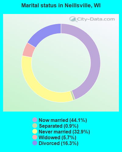
- Never married: 32.9%
- Now married: 44.1%
- Separated: 0.9%
- Widowed: 5.7%
- Divorced: 16.3%
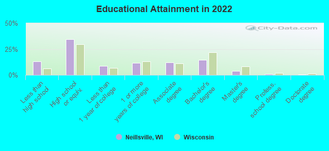
For population 25 years and over in Neillsville:
- High school or higher: 86.2%
- Bachelor's degree or higher: 19.0%
- Graduate or professional degree: 5.0%
- Unemployed: 4.2%
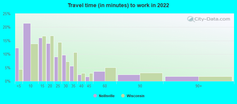
- Mean travel time to work (commute): 22.5 minutes
| Here: | 10.0 |
| Wisconsin average: | 10.4 |
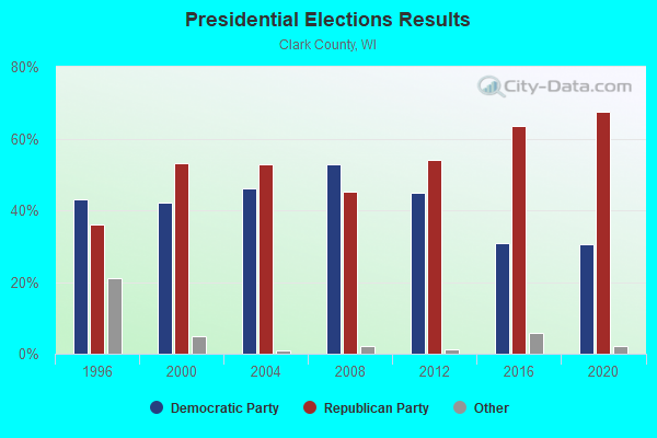
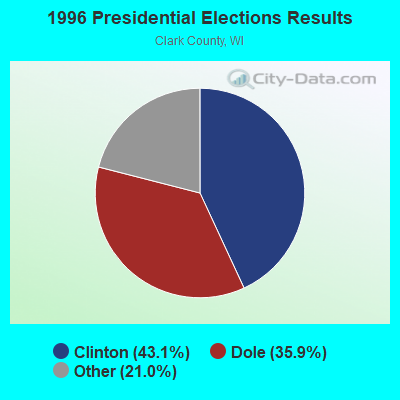
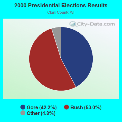
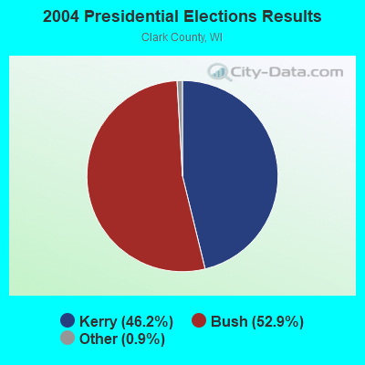
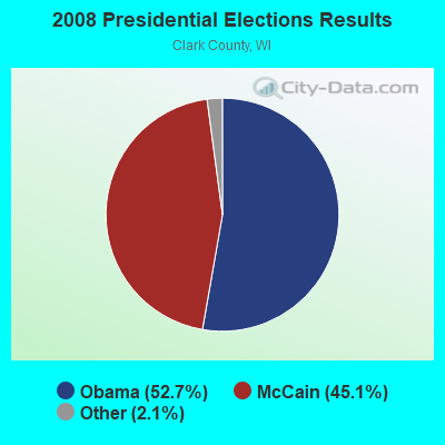
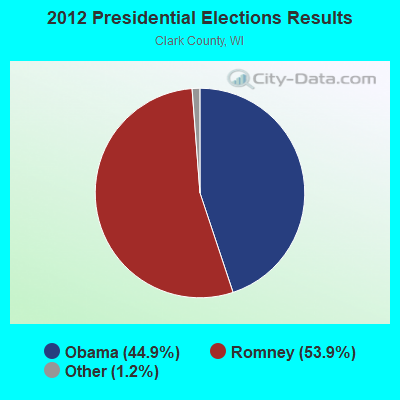
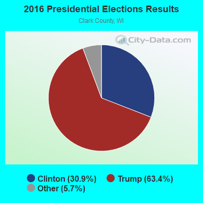
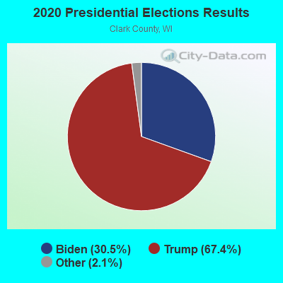
Graphs represent county-level data. Detailed 2008 Election Results
Religion statistics for Neillsville, WI (based on Clark County data)
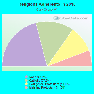
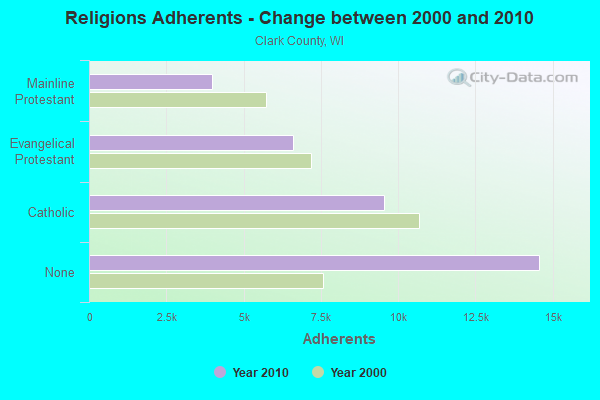
| Religion | Adherents | Congregations |
|---|---|---|
| Catholic | 9,535 | 9 |
| Evangelical Protestant | 6,594 | 41 |
| Mainline Protestant | 3,981 | 25 |
| Other | 7 | 5 |
| Orthodox | - | - |
| None | 14,573 | - |
Food Environment Statistics:
| This county: | 2.69 / 10,000 pop. |
| Wisconsin: | 1.86 / 10,000 pop. |
| Clark County: | 5.38 / 10,000 pop. |
| State: | 4.12 / 10,000 pop. |
| This county: | 7.78 / 10,000 pop. |
| Wisconsin: | 8.64 / 10,000 pop. |
| This county: | 7.9% |
| Wisconsin: | 7.6% |
| Clark County: | 28.3% |
| Wisconsin: | 27.5% |
| Clark County: | 16.2% |
| State: | 13.0% |
Health and Nutrition:
| Here: | 52.6% |
| Wisconsin: | 49.5% |
| Neillsville: | 49.0% |
| Wisconsin: | 46.6% |
| Neillsville: | 27.4 |
| State: | 28.7 |
| This city: | 17.2% |
| Wisconsin: | 21.4% |
| This city: | 22.1% |
| Wisconsin: | 10.2% |
| This city: | 6.9 |
| Wisconsin: | 6.8 |
| Neillsville: | 29.7% |
| State: | 34.0% |
| Neillsville: | 52.7% |
| Wisconsin: | 56.3% |
| Neillsville: | 81.8% |
| Wisconsin: | 78.5% |
More about Health and Nutrition of Neillsville, WI Residents
| Local government employment and payroll (March 2022) | |||||
| Function | Full-time employees | Monthly full-time payroll | Average yearly full-time wage | Part-time employees | Monthly part-time payroll |
|---|---|---|---|---|---|
| Police Protection - Officers | 6 | $30,763 | $61,526 | 0 | $0 |
| Streets and Highways | 4 | $14,977 | $44,931 | 0 | $0 |
| Other Government Administration | 3 | $13,359 | $53,436 | 8 | $3,333 |
| Parks and Recreation | 2 | $8,592 | $51,552 | 11 | $2,745 |
| Water Supply | 2 | $10,110 | $60,660 | 0 | $0 |
| Sewerage | 2 | $5,725 | $34,350 | 0 | $0 |
| Local Libraries | 1 | $3,082 | $36,984 | 4 | $3,001 |
| Police - Other | 1 | $3,336 | $40,032 | 1 | $115 |
| Judicial and Legal | 0 | $0 | 1 | $2,528 | |
| Health | 0 | $0 | 1 | $107 | |
| Other and Unallocable | 0 | $0 | 2 | $1,396 | |
| Firefighters | 0 | $0 | 27 | $4,768 | |
| Totals for Government | 21 | $89,943 | $51,396 | 55 | $17,993 |
Neillsville government finances - Expenditure in 2017 (per resident):
- Construction - Regular Highways: $92,000 ($39.71)
Parks and Recreation: $27,000 ($11.65)
General - Other: $7,000 ($3.02)
- Current Operations - Police Protection: $689,000 ($297.37)
Water Utilities: $581,000 ($250.76)
Sewerage: $535,000 ($230.90)
Regular Highways: $439,000 ($189.47)
Local Fire Protection: $274,000 ($118.26)
Parks and Recreation: $225,000 ($97.11)
Transit Utilities: $199,000 ($85.89)
Libraries: $160,000 ($69.05)
Solid Waste Management: $123,000 ($53.09)
Central Staff Services: $115,000 ($49.63)
General - Other: $110,000 ($47.48)
Miscellaneous Commercial Activities - Other: $87,000 ($37.55)
Financial Administration: $78,000 ($33.66)
Judicial and Legal Services: $41,000 ($17.70)
General Public Buildings: $33,000 ($14.24)
Air Transportation: $24,000 ($10.36)
Health - Other: $19,000 ($8.20)
Housing and Community Development: $10,000 ($4.32)
Natural Resources - Other: $4,000 ($1.73)
- General - Interest on Debt: $108,000 ($46.61)
- Other Capital Outlay - Local Fire Protection: $92,000 ($39.71)
Regular Highways: $8,000 ($3.45)
- Total Salaries and Wages: $1,121,000 ($483.82)
Neillsville government finances - Revenue in 2017 (per resident):
- Charges - Sewerage: $609,000 ($262.84)
Other: $190,000 ($82.00)
Housing and Community Development: $38,000 ($16.40)
Miscellaneous Commercial Activities: $23,000 ($9.93)
Parks and Recreation: $20,000 ($8.63)
Regular Highways: $4,000 ($1.73)
Air Transportation: $3,000 ($1.29)
Parking Facilities: $2,000 ($0.86)
- Local Intergovernmental - Other: $247,000 ($106.60)
- Miscellaneous - Donations From Private Sources: $120,000 ($51.79)
General Revenue - Other: $46,000 ($19.85)
Fines and Forfeits: $38,000 ($16.40)
Interest Earnings: $19,000 ($8.20)
Rents: $11,000 ($4.75)
Sale of Property: $3,000 ($1.29)
- Revenue - Water Utilities: $464,000 ($200.26)
Transit Utilities: $40,000 ($17.26)
- State Intergovernmental - General Local Government Support: $912,000 ($393.61)
Highways: $181,000 ($78.12)
Education: $47,000 ($20.28)
Other: $22,000 ($9.50)
- Tax - Property: $1,157,000 ($499.35)
Other Selective Sales: $25,000 ($10.79)
Other: $14,000 ($6.04)
Occupation and Business License - Other: $9,000 ($3.88)
Other License: $2,000 ($0.86)
Neillsville government finances - Debt in 2017 (per resident):
- Long Term Debt - Beginning Outstanding - Unspecified Public Purpose: $2,909,000 ($1255.50)
Outstanding Unspecified Public Purpose: $2,402,000 ($1036.69)
Retired Unspecified Public Purpose: $1,600,000 ($690.55)
Issue, Unspecified Public Purpose: $1,093,000 ($471.73)
Neillsville government finances - Cash and Securities in 2017 (per resident):
- Other Funds - Cash and Securities: $5,543,000 ($2392.32)
| Businesses in Neillsville, WI | ||||
| Name | Count | Name | Count | |
|---|---|---|---|---|
| Ace Hardware | 1 | Lane Furniture | 1 | |
| Chevrolet | 1 | Pizza Hut | 1 | |
| Curves | 1 | Super 8 | 1 | |
| H&R Block | 1 | U-Haul | 1 | |
| Hardee's | 1 | |||
Strongest AM radio stations in Neillsville:
- WCCN (1370 AM; 5 kW; NEILLSVILLE, WI; Owner: CENTRAL WISCONSIN BROADCASTING, INC.)
- WSPT (1010 AM; 50 kW; STEVENS POINT, WI)
- WSAU (550 AM; 20 kW; WAUSAU, WI; Owner: WRIG, INC.)
- WLBL (930 AM; 5 kW; AUBURNDALE, WI; Owner: STATE OF WISCONSIN - EDUCATIONAL COMMUNICATIONS BOARD)
- WCTS (1030 AM; 50 kW; MAPLEWOOD, MN; Owner: CNTL. BAPT. THEO/AL SEMI MINNEAPOLIS)
- WNAM (1280 AM; 50 kW; NEENAH-MENASHA, WI; Owner: CUMULUS LICENSING CORP.)
- WEBC (560 AM; 50 kW; DULUTH, MN)
- WCCO (830 AM; 50 kW; MINNEAPOLIS, MN; Owner: INFINITY MEDIA CORPORATION)
- WAYY (790 AM; 5 kW; EAU CLAIRE, WI; Owner: MAVERICK MEDIA OF EAU CLAIRE LICENSE LLC)
- WRIG (1390 AM; 10 kW; SCHOFIELD, WI; Owner: WRIG, INC.)
- WMEQ (880 AM; 10 kW; MENOMONIE, WI; Owner: CAPSTAR TX LIMITED PARTNERSHIP)
- WFHR (1320 AM; 5 kW; WISCONSIN RAPIDS, WI; Owner: WISCONSIN RAPIDS BROADCASTING, LLC)
- KFAN (1130 AM; 50 kW; MINNEAPOLIS, MN; Owner: AMFM RADIO LICENSES, L.L.C.)
Strongest FM radio stations in Neillsville:
- WCCN-FM (107.5 FM; NEILLSVILLE, WI; Owner: CENTRAL WISCONSIN B/CG INC.)
- WAXX (104.5 FM; EAU CLAIRE, WI; Owner: MAVERICK MEDIA OF EAU CLAIRE LICENSE LLC)
- WGLX-FM (103.3 FM; WISCONSIN RAPIDS, WI; Owner: WISCONSIN RAPIDS BROADCASTING, LLC)
- WLJY (106.5 FM; MARSHFIELD, WI; Owner: NEWRADIO GROUP, LLC)
- WWIS-FM (99.7 FM; BLACK RIVER FALLS, WI; Owner: WWIS RADIO, INC.)
- WOSQ (92.3 FM; SPENCER, WI; Owner: NEWRADIO GROUP, LLC)
TV broadcast stations around Neillsville:
- WEAU-TV (Channel 13; EAU CLAIRE, WI; Owner: WEAU LICENSEE CORP.)
- WDLS-LP (Channel 35; TOMAH, WI; Owner: MAGNUM RADIO, INC.)
- WKBT (Channel 8; LA CROSSE, WI; Owner: QUEENB TELEVISION, LLC)
- W24BV (Channel 24; WHITING, WI; Owner: MS COMMUNICATIONS, LLC)
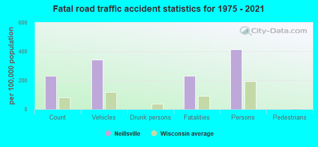
Neillsville fatal accident list:
Feb 10, 2011 01:46 PM, Us-10, Lat: 44.552672, Lon: -90.578189, Vehicles: 2, Persons: 2, Fatalities: 1
May 26, 2004 12:23 AM, Us-10, Vehicles: 1, Persons: 1, Fatalities: 1
Jan 14, 2000 11:35 AM, W Division St, Vehicles: 2, Persons: 3, Fatalities: 1
Jun 18, 1981 09:21 PM, Vehicles: 2, Persons: 2, Fatalities: 1
Aug 6, 1980 08:55 AM, Vehicles: 1, Persons: 2, Fatalities: 1
- National Bridge Inventory (NBI) Statistics
- 17Number of bridges
- 148ft / 45.4mTotal length
- $2,511,000Total costs
- 16,757Total average daily traffic
- 1,421Total average daily truck traffic
- 18,773Total future (year 2039) average daily traffic
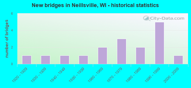
- New bridges - historical statistics
- 11920-1929
- 11930-1939
- 11940-1949
- 11950-1959
- 21960-1969
- 31970-1979
- 21980-1989
- 51990-1999
- 12000-2009
FCC Registered Cell Phone Towers:
3 (See the full list of FCC Registered Cell Phone Towers in Neillsville)FCC Registered Antenna Towers:
29 (See the full list of FCC Registered Antenna Towers)FCC Registered Commercial Land Mobile Towers:
1- Call Sign: KH4427, Licensee ID: L00125069,
Assigned Frequencies: 161.670 MHz, Grant Date: 07/20/2000, Expiration Date: 12/01/2028, Registrant: Central Wisconsin Broadcasting, Inc., P O Box 387, Neillsville, WI 54456, Email:
FCC Registered Broadcast Land Mobile Towers:
6- 1 Block W Of Jct Us 10 & Sth 73 (Lat: 44.554139 Lon: -90.593750), Call Sign: KJY896,
Assigned Frequencies: 39.5800 MHz, Grant Date: 02/24/2023, Expiration Date: 02/25/2033, Registrant: City Of Neillsville, 106 W. Division St., Neillsville, WI 54456, Phone: (715) 743-5678, Email:
- 4th & Huron Sts (Lat: 44.611361 Lon: -90.591528), Call Sign: KVJ628,
Assigned Frequencies: 39.5800 MHz, Grant Date: 10/29/2002, Expiration Date: 01/12/2013, Cancellation Date: 03/16/2013, Registrant: Northway Communications Inc., 105 East Oak Street, Wausau, WI 54401, Phone: (715) 842-0841, Fax: (715) 848-1413, Email:
- JAIL, Sheriffs Dept (Lat: 44.560389 Lon: -90.593667), Type: Tower, Structure height: 6 m, Overall height: 12 m, Call Sign: WBE358,
Assigned Frequencies: 153.920 MHz, 154.800 MHz, Grant Date: 02/26/2015, Expiration Date: 05/21/2025, Registrant: Northway Communications Inc., 105 East Oak Street, Wausau, WI 54456, Phone: (715) 842-0841, Fax: (715) 848-1413, Email:
- Lat: 44.554417 Lon: -90.614861, Call Sign: WQCR313,
Assigned Frequencies: 451.337 MHz, 451.437 MHz, Grant Date: 03/27/2015, Expiration Date: 05/06/2025, Certifier: Craig A Jero, Registrant: General Communications Inc, 2880 Commerce Park Drive, Madison, WI 53719, Phone: (608) 310-7091, Fax: (715) 848-1413, Email:
- COURTHOUSE, 517 Court Street (Lat: 44.560639 Lon: -90.593833), Type: Mtower, Structure height: 59.4 m, Overall height: 60.7 m, Call Sign: WQTS954,
Assigned Frequencies: 153.845 MHz, 159.000 MHz, 153.920 MHz, 155.370 MHz, 156.075 MHz, 158.955 MHz, 155.475 MHz, Grant Date: 04/07/2014, Expiration Date: 04/07/2024, Certifier: James Backus, Registrant: Psc Alliance, Inc, Suite 300 - 7900 International Drive, Bloomington, MN 55425, Phone: (651) 770-9328, Fax: (888) 384-9171, Email:
- Lat: 44.444528 Lon: -90.692333, Call Sign: WRDE364,
Assigned Frequencies: 152.270 MHz, 153.080 MHz, 153.200 MHz, 157.530 MHz, 158.302 MHz, Grant Date: 04/08/2019, Expiration Date: 04/08/2029, Certifier: Michael T Vail, Registrant: Graybill Communications Inc, 305 Miller Rd, Hiawatha, IA 52233, Phone: (319) 393-5456, Fax: (319) 393-5458, Email:
FCC Registered Microwave Towers:
5- 1201 E Division St (Lat: 44.551333 Lon: -90.578722), Overall height: 22.9 m, Call Sign: WMV292, Licensee ID: L00125069,
Assigned Frequencies: 946.500 MHz, Grant Date: 11/30/1994, Expiration Date: 12/01/2028, Registrant: Central Wisconsin Broadcasting, Inc., P O Box 387, Neillsville, WI 54456, Email:
- STATION, 401 Center St (Lat: 43.559139 Lon: -90.589833), Overall height: 36.6 m, Call Sign: WNTE202,
Assigned Frequencies: 6790.00 MHz, Grant Date: 04/26/1995, Expiration Date: 04/26/2000, Cancellation Date: 07/30/2000, Phone: (715) 833-6211
- NEILLSVILLE, 7.5 Mi Nnw (Lat: 44.653861 Lon: -90.675417), Type: Gtower, Structure height: 91.4 m, Overall height: 97.5 m, Call Sign: WQLL944,
Assigned Frequencies: 6785.00 MHz, 6785.00 MHz, 6785.00 MHz, 6785.00 MHz, 6785.00 MHz, 6785.00 MHz, 6785.00 MHz, Grant Date: 12/10/2019, Expiration Date: 03/04/2030, Certifier: Carl R Guse, Registrant: Wisconsin State Patrol, 4822 Madison Yards Way - 9th Fl South, Madison, WI 53705, Phone: (608) 709-0095, Email:
- NEILLSVILLE, 517 Court Street (Lat: 44.560639 Lon: -90.593833), Type: Mtower, Structure height: 60 m, Call Sign: WRAU301, Licensee ID: L01632258,
Assigned Frequencies: 6034.15 MHz, 6034.15 MHz, 6034.15 MHz, 6034.15 MHz, 6034.15 MHz, 6034.15 MHz, 6034.15 MHz, Grant Date: 03/05/2018, Expiration Date: 03/05/2028, Certifier: John Ross, Registrant: County Of (Wisconsin) Clark, 517 Court St Room 306, Neillsville, WI 54456, Phone: (715) 743-5100, Fax: (715) 743-4350, Email:
- WCCN tower, S Mound Rd .8 Km W Of Int With Langs Rd (Lat: 44.591667 Lon: -90.619444), Type: Gtower, Structure height: 151 m, Overall height: 152 m, Call Sign: WRPX973,
Assigned Frequencies: 11485.0 MHz, 11485.0 MHz, 11485.0 MHz, 11485.0 MHz, Grant Date: 04/06/2022, Expiration Date: 04/06/2032, Certifier: Steve R Selk, Registrant: Micronet Communications, Inc., 812 Lexington Dr, Plano, TX 75075, Phone: (972) 422-7200, Email:
FCC Registered Maritime Coast & Aviation Ground Towers:
2- Neillsville Municipal Airport (Lat: 44.554417 Lon: -90.512083), Type: Building, Overall height: 4 m, Call Sign: KRT6, Licensee ID: L00006889,
Assigned Frequencies: 122.800 MHz, Grant Date: 04/20/1995, Expiration Date: 05/17/2000, Cancellation Date: 05/06/2001, Registrant: City Of Neillsville, N 3770 Miller Ave, Neillsville, WI 54456
- Neillsville Municipal Airport (Lat: 44.556944 Lon: -90.536111), Type: Tower, Call Sign: WRLB3166,
Assigned Frequencies: 0.36851 MHz, Grant Date: 10/21/2015, Expiration Date: 12/14/2025, Registrant: Airport Manager, N3675 Pray Ave, Neillsville, WI 54456, Phone: (715) 743-4400, Fax: (715) 384-5251, Email:
FCC Registered Amateur Radio Licenses:
20 (See the full list of FCC Registered Amateur Radio Licenses in Neillsville)FAA Registered Aircraft:
30 (See the full list of FAA Registered Aircraft in Neillsville)2004 - 2018 National Fire Incident Reporting System (NFIRS) incidents
- Fire incident types reported to NFIRS in Neillsville, WI
- 9449.2%Structure Fires
- 6333.0%Outside Fires
- 3116.2%Mobile Property/Vehicle Fires
- 31.6%Other
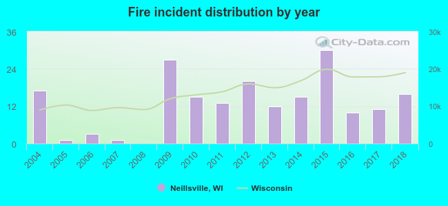 Based on the data from the years 2004 - 2018 the average number of fires per year is 13. The highest number of reported fires - 30 took place in 2015, and the least - 0 in 2008. The data has a dropping trend.
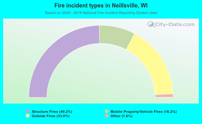 When looking into fire subcategories, the most reports belonged to: Structure Fires (49.2%), and Outside Fires (33.0%).
| Most common first names in Neillsville, WI among deceased individuals | ||
| Name | Count | Lived (average) |
|---|---|---|
| William | 62 | 81.3 years |
| John | 57 | 80.9 years |
| Mary | 48 | 85.2 years |
| Frank | 40 | 78.7 years |
| Helen | 38 | 82.0 years |
| Anna | 38 | 86.0 years |
| George | 36 | 80.0 years |
| Arthur | 34 | 78.8 years |
| Robert | 33 | 71.8 years |
| Walter | 30 | 78.2 years |
| Most common last names in Neillsville, WI among deceased individuals | ||
| Last name | Count | Lived (average) |
|---|---|---|
| Smith | 21 | 82.8 years |
| Dux | 18 | 80.8 years |
| Schmidt | 17 | 82.9 years |
| Johnson | 15 | 80.5 years |
| Drescher | 14 | 78.8 years |
| Miller | 14 | 77.8 years |
| Schultz | 14 | 81.3 years |
| Kalsow | 12 | 82.6 years |
| Meier | 12 | 75.0 years |
| Matousek | 11 | 84.4 years |
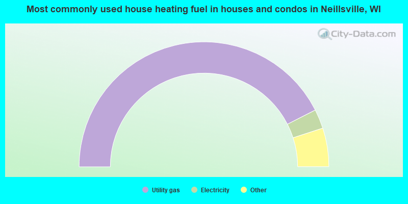
- 85.1%Utility gas
- 5.0%Electricity
- 4.0%Fuel oil, kerosene, etc.
- 3.0%Bottled, tank, or LP gas
- 3.0%Wood
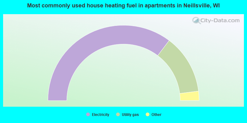
- 70.8%Electricity
- 25.4%Utility gas
- 2.4%Other fuel
- 1.2%Wood
- 0.3%Bottled, tank, or LP gas
Neillsville compared to Wisconsin state average:
- Median house value below state average.
- Unemployed percentage significantly below state average.
- Black race population percentage significantly below state average.
- Hispanic race population percentage significantly below state average.
- Foreign-born population percentage significantly below state average.
- Length of stay since moving in above state average.
- House age above state average.
- Institutionalized population percentage significantly above state average.
- Number of college students significantly below state average.
Neillsville on our top lists:
- #63 on the list of "Top 101 cities with the largest percentage of people in other nonhousehold living situations (population 1,000+)"

|
Total of 3 patent applications in 2008-2024.