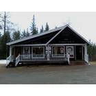
New Portland, Maine
Submit your own pictures of this town and show them to the world
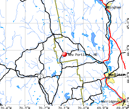
- OSM Map
- General Map
- Google Map
- MSN Map
Population change since 2000: -8.5%
 |
| Males: 375 | |
| Females: 343 |
| Median resident age: | 48.9 years |
| Maine median age: | 43.0 years |
Zip codes: 04961.
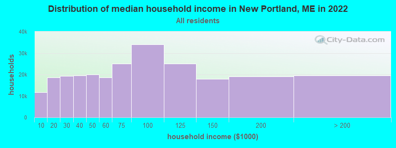
| New Portland: | $54,168 |
| ME: | $69,543 |
Estimated per capita income in 2022: $30,664 (it was $14,596 in 2000)
New Portland town income, earnings, and wages data
Estimated median house or condo value in 2022: $177,857 (it was $66,700 in 2000)
| New Portland: | $177,857 |
| ME: | $290,600 |
Mean prices in 2022: all housing units: $190,782; detached houses: $204,176; townhouses or other attached units: $200,500; in 2-unit structures: $144,246; in 3-to-4-unit structures: $441,593; in 5-or-more-unit structures: $270,949; mobile homes: $101,406; occupied boats, rvs, vans, etc.: $711,279
Detailed information about poverty and poor residents in New Portland, ME


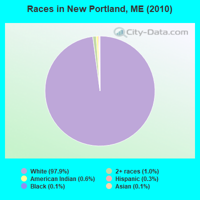
- 70397.9%White alone
- 71.0%Two or more races
- 40.6%American Indian alone
- 20.3%Hispanic
- 10.1%Black alone
- 10.1%Asian alone
Races in New Portland detailed stats: ancestries, foreign born residents, place of birth
According to our research of Maine and other state lists, there were 2 registered sex offenders living in New Portland, Maine as of April 23, 2024.
The ratio of all residents to sex offenders in New Portland is 359 to 1.
 Recent articles from our blog. Our writers, many of them Ph.D. graduates or candidates, create easy-to-read articles on a wide variety of topics.


 | Maine weather thread (3207 replies) |
| Maine Population Shifts (44 replies) |
| I'm 1/2 way set to move to The Pinetree State... (10 replies) |
| Maine Long Term Rail / Transit plans and Proposals (68 replies) |
| I think this is controversial... (38 replies) |
| great hiking in Maine (51 replies) |
Latest news from New Portland, ME collected exclusively by city-data.com from local newspapers, TV, and radio stations
Ancestries: English (24.2%), French (13.6%), Irish (12.6%), United States (11.2%), German (9.4%), French Canadian (7.8%).
Current Local Time: EST time zone
Incorporated on 03/09/1808
Elevation: 500 feet
Land area: 43.4 square miles.
Population density: 17 people per square mile (very low).
24 residents are foreign born (1.7% North America, 1.4% Europe).
| This town: | 3.1% |
| Maine: | 2.9% |
| New Portland town: | 1.1% ($762) |
| Maine: | 1.5% ($1,417) |
Nearest city with pop. 50,000+: Portland, ME  (87.1 miles , pop. 64,249).
Nearest city with pop. 200,000+: Boston, MA (186.6 miles , pop. 589,141).
Nearest city with pop. 1,000,000+: Bronx, NY (341.1 miles , pop. 1,332,650).
Nearest cities:
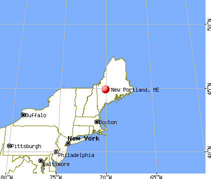
), ), ), Latitude: 44.92 N, Longitude: 70.07 W
Area code commonly used in this area: 207

| Here: | 4.7% |
| Maine: | 3.4% |

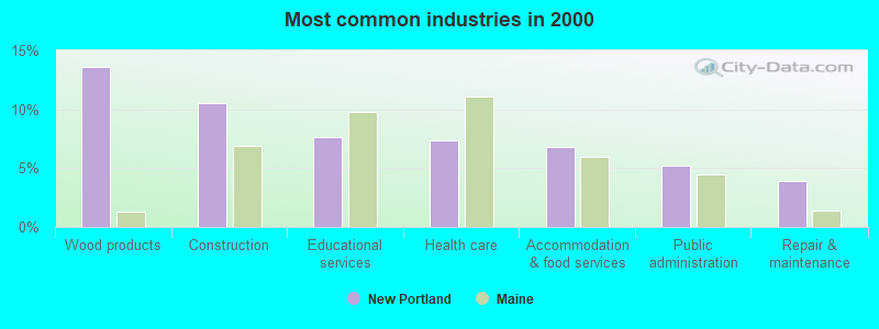
- Wood products (13.6%)
- Construction (10.5%)
- Educational services (7.6%)
- Health care (7.3%)
- Accommodation & food services (6.8%)
- Public administration (5.2%)
- Repair & maintenance (3.9%)

- Construction (19.6%)
- Wood products (12.2%)
- Repair & maintenance (7.9%)
- Public administration (6.9%)
- Truck transportation (5.8%)
- Agriculture, forestry, fishing & hunting (5.3%)
- Accommodation & food services (5.3%)

- Wood products (15.1%)
- Health care (12.0%)
- Educational services (11.5%)
- Accommodation & food services (8.3%)
- Administrative & support & waste management services (4.2%)
- Public administration (3.6%)
- Finance & insurance (3.1%)

- Other production occupations, including supervisors (10.2%)
- Electrical equipment mechanics and other installation, maintenance, and repair workers, including supervisors (5.2%)
- Building and grounds cleaning and maintenance occupations (4.7%)
- Other sales and related occupations, including supervisors (4.5%)
- Vehicle and mobile equipment mechanics, installers, and repairers (3.9%)
- Other office and administrative support workers, including supervisors (3.7%)
- Construction traders workers except carpenters, electricians, painters, plumbers, and construction laborers (3.4%)

- Other production occupations, including supervisors (11.6%)
- Electrical equipment mechanics and other installation, maintenance, and repair workers, including supervisors (9.5%)
- Vehicle and mobile equipment mechanics, installers, and repairers (7.9%)
- Construction traders workers except carpenters, electricians, painters, plumbers, and construction laborers (6.9%)
- Driver/sales workers and truck drivers (6.3%)
- Laborers and material movers, hand (4.2%)
- Fishing, hunting, and forestry occupations (3.7%)

- Other production occupations, including supervisors (8.9%)
- Other sales and related occupations, including supervisors (7.8%)
- Other office and administrative support workers, including supervisors (7.3%)
- Building and grounds cleaning and maintenance occupations (6.8%)
- Textile, apparel, and furnishings workers (5.7%)
- Preschool, kindergarten, elementary, and middle school teachers (4.2%)
- Secretaries and administrative assistants (4.2%)
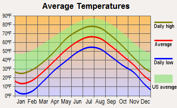
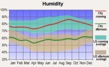
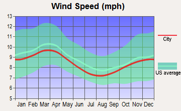
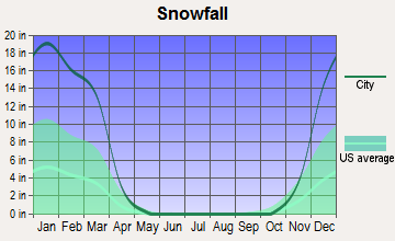
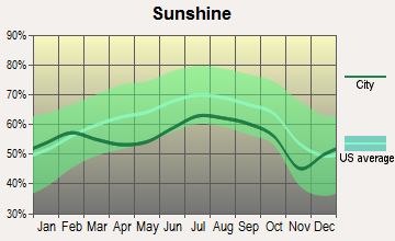
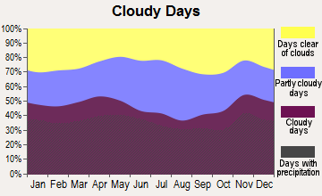
Average climate in New Portland, Maine
Based on data reported by over 4,000 weather stations

(lower is better)
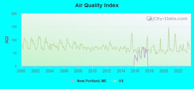
Air Quality Index (AQI) level in 2017 was 57.9. This is better than average.
| City: | 57.9 |
| U.S.: | 72.6 |
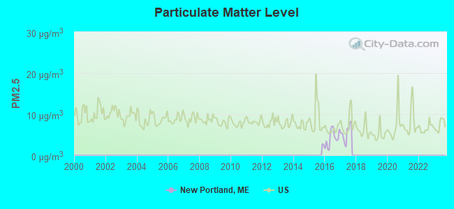
Particulate Matter (PM2.5) [µg/m3] level in 2017 was 5.49. This is significantly better than average. Closest monitor was 13.2 miles away from the city center.
| City: | 5.49 |
| U.S.: | 8.11 |
Earthquake activity:
New Portland-area historical earthquake activity is significantly above Maine state average. It is 79% smaller than the overall U.S. average.On 4/20/2002 at 10:50:47, a magnitude 5.3 (5.3 ML, Depth: 3.0 mi, Class: Moderate, Intensity: VI - VII) earthquake occurred 180.4 miles away from New Portland center
On 4/20/2002 at 10:50:47, a magnitude 5.2 (5.2 MB, 4.2 MS, 5.2 MW, 5.0 MW) earthquake occurred 181.7 miles away from New Portland center
On 10/16/2012 at 23:12:25, a magnitude 4.7 (4.7 ML, Depth: 10.0 mi, Class: Light, Intensity: IV - V) earthquake occurred 95.7 miles away from the city center
On 10/7/1983 at 10:18:46, a magnitude 5.3 (5.1 MB, 5.3 LG, 5.1 ML) earthquake occurred 221.2 miles away from New Portland center
On 1/19/1982 at 00:14:42, a magnitude 4.7 (4.5 MB, 4.7 MD, 4.5 LG) earthquake occurred 123.9 miles away from the city center
On 2/26/1999 at 03:38:43, a magnitude 3.8 (3.8 LG, Depth: 2.0 mi, Class: Light, Intensity: II - III) earthquake occurred 40.6 miles away from the city center
Magnitude types: regional Lg-wave magnitude (LG), body-wave magnitude (MB), duration magnitude (MD), local magnitude (ML), surface-wave magnitude (MS), moment magnitude (MW)
Natural disasters:
The number of natural disasters in Somerset County (24) is greater than the US average (15).Major Disasters (Presidential) Declared: 16
Emergencies Declared: 7
Causes of natural disasters: Floods: 14, Storms: 13, Snows: 7, Heavy Rains: 2, Hurricanes: 2, Blizzard: 1, Ice Storm: 1, Landslide: 1, Snowfall: 1, Wind: 1, Winter Storm: 1, Other: 1 (Note: some incidents may be assigned to more than one category).
Colleges/universities with over 2000 students nearest to New Portland:
- University of Maine at Farmington (about 18 miles; Farmington, ME; Full-time enrollment: 2,036)
- University of Maine at Augusta (about 43 miles; Augusta, ME; FT enrollment: 3,204)
- Husson University (about 64 miles; Bangor, ME; FT enrollment: 2,421)
- University of Maine (about 69 miles; Orono, ME; FT enrollment: 8,931)
- Saint Joseph's College of Maine (about 79 miles; Standish, ME; FT enrollment: 2,010)
- University of Southern Maine (about 88 miles; Portland, ME; FT enrollment: 6,647)
- Southern Maine Community College (about 89 miles; South Portland, ME; FT enrollment: 4,666)
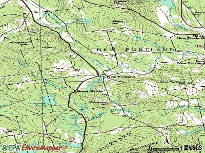
Points of interest:
Notable locations in New Portland: Great Works (A), New Portland Fire Department (B). Display/hide their locations on the map
Lakes and reservoirs: Gammon Pond (A), Lemon Stream (B), Pennell Pond (C), Gilman Stream Reservoir (D). Display/hide their locations on the map
Streams, rivers, and creeks: Lemon Stream (A), Meadow Brook (B), Taylor Brook (C), Dyer Brook (D), Gilman Stream (E), Luce Brook (F), Clarks Brook (G), Harris Brook (H), Indian Stream (I). Display/hide their locations on the map
Birthplace of: Abram Williams - Politician.
| This town: | 2.1 people |
| Maine: | 2.3 people |
| This town: | 58.4% |
| Whole state: | 62.9% |
| This town: | 10.1% |
| Whole state: | 9.4% |
Likely homosexual households (counted as self-reported same-sex unmarried-partner households)
- Lesbian couples: 0.3% of all households
- Gay men: 0.3% of all households
| This town: | 11.6% |
| Whole state: | 10.9% |
| This town: | 5.5% |
| Whole state: | 4.1% |
For population 15 years and over in New Portland:

- Never married: 23.4%
- Now married: 57.7%
- Separated: 1.2%
- Widowed: 6.4%
- Divorced: 11.2%
For population 25 years and over in New Portland:
- High school or higher: 88.0%
- Bachelor's degree or higher: 14.6%
- Graduate or professional degree: 4.5%
- Unemployed: 5.5%
- Mean travel time to work (commute): 25.7 minutes


| Here: | 8.9 |
| Maine average: | 11.2 |

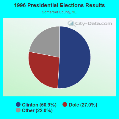
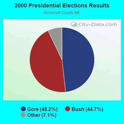


Graphs represent county-level data. Detailed 2008 Election Results
Religion statistics for New Portland, ME (based on Somerset County data)
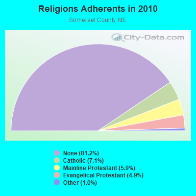
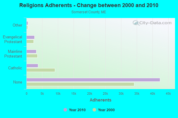
| Religion | Adherents | Congregations |
|---|---|---|
| Catholic | 3,694 | 7 |
| Mainline Protestant | 3,094 | 28 |
| Evangelical Protestant | 2,552 | 32 |
| Other | 501 | 3 |
| None | 42,387 | - |
Food Environment Statistics:
| Here: | 2.52 / 10,000 pop. |
| Maine: | 2.80 / 10,000 pop. |
| Somerset County: | 0.19 / 10,000 pop. |
| Maine: | 0.14 / 10,000 pop. |
| Here: | 2.71 / 10,000 pop. |
| State: | 2.20 / 10,000 pop. |
| Somerset County: | 9.31 / 10,000 pop. |
| Maine: | 5.75 / 10,000 pop. |
| Somerset County: | 8.14 / 10,000 pop. |
| State: | 11.02 / 10,000 pop. |
| Here: | 10.2% |
| State: | 8.2% |
| This county: | 31.7% |
| Maine: | 25.0% |
Strongest AM radio stations in New Portland:
- WSKW (1160 AM; 10 kW; SKOWHEGAN, ME; Owner: MOUNTAIN WIRELESS, INCORPORATED)
- WTME (780 AM; 10 kW; RUMFORD, ME; Owner: MOUNTAIN VALLEY BROADCASTING, INC.)
- WRKO (680 AM; 50 kW; BOSTON, MA; Owner: ENTERCOM BOSTON LICENSE, LLC)
- WZON (620 AM; 5 kW; BANGOR, ME; Owner: THE ZONE CORPORATION)
- WFAU (1280 AM; 5 kW; GARDINER, ME; Owner: CAPSTAR TX LIMITED PARTNERSHIP)
- WCHP (760 AM; 35 kW; CHAMPLAIN, NY; Owner: CHAMPLAIN RADIO, INC.)
- WEEI (850 AM; 50 kW; BOSTON, MA; Owner: ENTERCOM BOSTON LICENSE, LLC)
- WMTW (870 AM; 10 kW; GORHAM, ME; Owner: RADIO PARTNERS OF MAINE, L.P.)
- WBZ (1030 AM; 50 kW; BOSTON, MA; Owner: INFINITY BROADCASTING OPERATIONS, INC.)
- WCRN (830 AM; 50 kW; WORCESTER, MA; Owner: CARTER BROADCASTING CORPORATION)
- WNNZ (640 AM; 50 kW; WESTFIELD, MA; Owner: CLEAR CHANNEL BROADCASTING LICENSES, INC.)
- WABI (910 AM; 5 kW; BANGOR, ME; Owner: CLEAR CHANNEL BROADCASTING LICENSES, INC.)
- WGAN (560 AM; 5 kW; PORTLAND, ME; Owner: SAGA COMMUNICATIONS OF NEW ENGLAND, LLC)
Strongest FM radio stations in New Portland:
- WTOS-FM (105.1 FM; SKOWHEGAN, ME; Owner: CAPSTAR TX LIMITED PARTNERSHIP)
- WIGY (97.5 FM; MADISON, ME; Owner: CAPSTAR TX LIMITED PARTNERSHIP)
- WLOB-FM (96.3 FM; RUMFORD, ME; Owner: ATLANTIC COAST RADIO, LLC)
- WPKQ (103.7 FM; NORTH CONWAY, NH; Owner: CITADEL BROADCASTING COMPANY)
- WHOM (94.9 FM; MT. WASHINGTON, NH; Owner: CITADEL BROADCASTING COMPANY)
- WHQO (107.9 FM; SKOWHEGAN, ME; Owner: MOUNTAIN WIRELESS, INC.)
- WTBM (100.7 FM; MEXICO, ME; Owner: MOUNTAIN VALLEY BROADCASTING, INC.)
- WKTJ-FM (99.3 FM; FARMINGTON, ME; Owner: FRANKLIN BROADCASTING CORPORATION)
- WQCB (106.5 FM; BREWER, ME; Owner: CUMULUS LICENSING CORP.)
- WWWA (95.3 FM; WINSLOW, ME; Owner: LIGHT OF LIFE MINISTRIES, INC.)
- WCTB (93.5 FM; FAIRFIELD, ME; Owner: MOUNTAIN WIRELESS, INC.)
TV broadcast stations around New Portland:
- W21BI (Channel 21; FARMINGTON, ME; Owner: TRINITY BROADCASTING NETWORK)
- New Portland, Maine
- Fatal accident count9
- Vehicles involved in fatal accidents12
- Fatal accidents involving drunk persons:4
- Fatalities9
- Persons involved in fatal accidents17
- Pedestrians involved in fatal accidents0
- Maine average
- Fatal accident count1367
- Vehicles involved in fatal accidents2052
- Fatal accidents involving drunk persons482
- Fatalities1475
- Persons involved in fatal accidents3136
- Pedestrians involved in fatal accidents127
- National Bridge Inventory (NBI) Statistics
- 10Number of bridges
- 95ft / 28.6mTotal length
- 11,586Total average daily traffic
- 574Total average daily truck traffic
- 17,033Total future (year 2036) average daily traffic

- New bridges - historical statistics
- 1Before 1900
- 41920-1929
- 11930-1939
- 21950-1959
- 11990-1999
- 12000-2009
FCC Registered Microwave Towers:
1- New Portland, 52 Meadow Brook Road (Lat: 44.909472 Lon: -70.009556), Type: Ltower, Structure height: 58.2 m, Overall height: 59.4 m, Call Sign: WQUI968,
Assigned Frequencies: 11225.0 MHz, 19475.0 MHz, 11225.0 MHz, 19475.0 MHz, 11225.0 MHz, 19475.0 MHz, 11225.0 MHz, 19475.0 MHz, 11225.0 MHz, 19475.0 MHz... (+8 more), Grant Date: 07/22/2014, Expiration Date: 07/22/2024, Cancellation Date: 10/23/2020, Certifier: Jessica B Lyons, Registrant: At&t Services, Inc., 208 S. Akard Street, Room 2100, Dallas, TX 75202, Phone: (855) 699-7073, Email:
FCC Registered Amateur Radio Licenses:
2- Call Sign: K1VEQ, Licensee ID: L01241060, Grant Date: 01/31/2007, Expiration Date: 04/04/2017, Cancellation Date: 04/05/2019, Certifier: Robert G Kennedy, Registrant: Robert G Kennedy, New Portland, ME 04954
- Call Sign: N1ULY, Licensee ID: L00830449, Grant Date: 03/24/2015, Expiration Date: 05/19/2025, Certifier: Lloyd C Dalton, Registrant: Lloyd C Dalton, 40 Bog Road, New Portland, ME 04961
FAA Registered Aircraft:
2- Aircraft: PIPER PA-12 (Category: Land, Seats: 3, Weight: Up to 12,499 Pounds, Speed: 82 mph), Engine: LYCOMING 0-235 SERIES (115 HP) (Reciprocating)
N-Number: 3511M, N3511M, N-3511M, Serial Number: 12-2093, Year manufactured: 1947, Airworthiness Date: 05/14/1956, Certificate Issue Date: 06/27/1979
Registrant (Individual): Gary Cobb, Po Box 124, New Portland, ME 04961 - Aircraft: CESSNA U206G (Category: Land, Seats: 6, Weight: Up to 12,499 Pounds, Speed: 132 mph), Engine: CONT MOTOR IO 520 SERIES (285 HP) (Reciprocating)
N-Number: 3951S, N3951S, N-3951S, Serial Number: U20604272, Year manufactured: 1978, Airworthiness Date: 07/11/1983, Certificate Issue Date: 09/05/2012
Registrant (Individual): Austin J Lopez, Po Box 163, New Portland, ME 04961
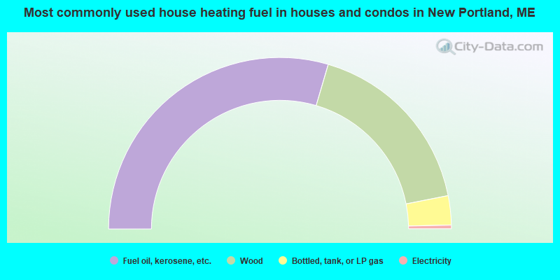
- 59.1%Fuel oil, kerosene, etc.
- 34.7%Wood
- 5.5%Bottled, tank, or LP gas
- 0.7%Electricity
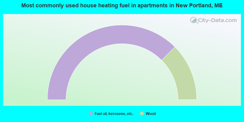
- 75.0%Fuel oil, kerosene, etc.
- 25.0%Wood
New Portland compared to Maine state average:
- Median house value below state average.
- Unemployed percentage below state average.
- Black race population percentage significantly below state average.
- Hispanic race population percentage significantly below state average.
- Median age above state average.
- Renting percentage significantly below state average.
- Length of stay since moving in significantly above state average.
- Number of rooms per house significantly below state average.
- House age significantly below state average.
- Percentage of population with a bachelor's degree or higher below state average.