Newaukum, Washington
Submit your own pictures of this place and show them to the world
- OSM Map
- General Map
- Google Map
- MSN Map

| Males: 1,177 | |
| Females: 1,092 |
| Median resident age: | 39.3 years |
| Washington median age: | 35.3 years |
Zip code: 98532
| Newaukum: | $81,081 |
| WA: | $91,306 |
Estimated per capita income in 2022: $39,478 (it was $19,505 in 2000)
Newaukum CCD income, earnings, and wages data
Estimated median house or condo value in 2022: $449,594 (it was $135,400 in 2000)
| Newaukum: | $449,594 |
| WA: | $569,500 |
Mean prices in 2022: all housing units: $376,342; detached houses: $412,728; townhouses or other attached units: $208,842; in 2-unit structures: $276,072; in 3-to-4-unit structures: $295,255; in 5-or-more-unit structures: $233,707; mobile homes: $266,018; occupied boats, rvs, vans, etc.: $88,764
Detailed information about poverty and poor residents in Newaukum, WA


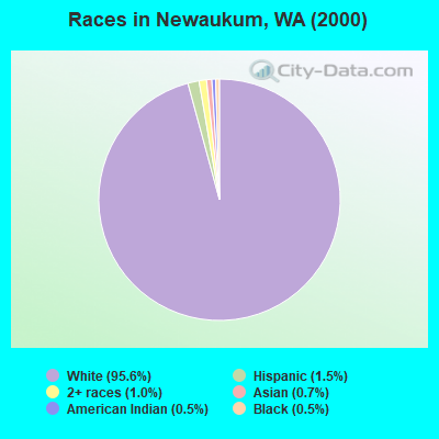
- 2,01995.6%White alone
- 321.5%Hispanic
- 221.0%Two or more races
- 150.7%Asian alone
- 100.5%Black alone
- 110.5%American Indian alone
- 20.09%Native Hawaiian and Other
Pacific Islander alone - 20.09%Other race alone
Races in Newaukum detailed stats: ancestries, foreign born residents, place of birth
 Recent articles from our blog. Our writers, many of them Ph.D. graduates or candidates, create easy-to-read articles on a wide variety of topics.

Current Local Time: PST time zone
Land area: 21.3 square miles.
Population density: 106 people per square mile (very low).

| Newaukum CCD: | 1.0% ($1,414) |
| Washington: | 1.2% ($1,915) |
Nearest city with pop. 50,000+: Lakewood, WA  (43.4 miles , pop. 58,211).
Nearest city with pop. 200,000+: Seattle, WA (76.2 miles , pop. 563,374).
Nearest city with pop. 1,000,000+: Los Angeles, CA (898.9 miles , pop. 3,694,820).
Nearest cities:
), ), ), ), )Latitude: 46.61 N, Longitude: 122.96 W
Area code commonly used in this area: 360

| Here: | 6.3% |
| Washington: | 4.6% |
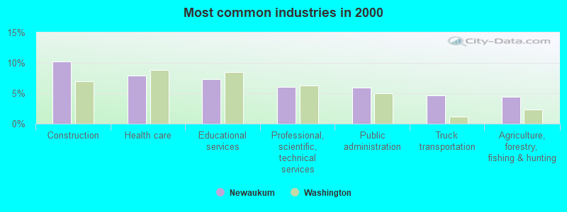
- Construction (10.2%)
- Health care (7.9%)
- Educational services (7.3%)
- Professional, scientific, technical services (6.0%)
- Public administration (5.9%)
- Truck transportation (4.7%)
- Agriculture, forestry, fishing & hunting (4.4%)
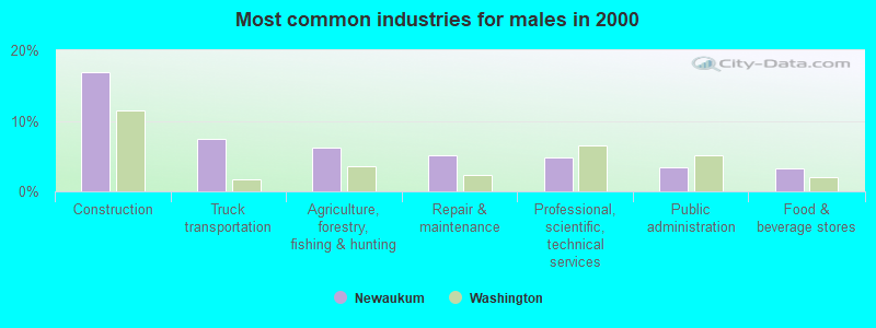
- Construction (17.0%)
- Truck transportation (7.4%)
- Agriculture, forestry, fishing & hunting (6.1%)
- Repair & maintenance (5.1%)
- Professional, scientific, technical services (4.9%)
- Public administration (3.4%)
- Food & beverage stores (3.2%)
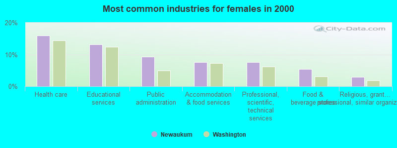
- Health care (15.9%)
- Educational services (13.2%)
- Public administration (9.3%)
- Accommodation & food services (7.6%)
- Professional, scientific, technical services (7.6%)
- Food & beverage stores (5.4%)
- Religious, grantmaking, civic, professional, similar organizations (2.9%)
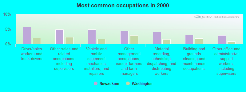
- Driver/sales workers and truck drivers (5.7%)
- Other sales and related occupations, including supervisors (4.9%)
- Vehicle and mobile equipment mechanics, installers, and repairers (4.9%)
- Other management occupations, except farmers and farm managers (4.5%)
- Material recording, scheduling, dispatching, and distributing workers (4.1%)
- Building and grounds cleaning and maintenance occupations (3.1%)
- Other office and administrative support workers, including supervisors (2.9%)
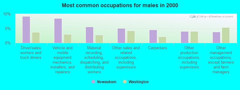
- Driver/sales workers and truck drivers (9.2%)
- Vehicle and mobile equipment mechanics, installers, and repairers (8.5%)
- Material recording, scheduling, dispatching, and distributing workers (5.6%)
- Other sales and related occupations, including supervisors (5.1%)
- Carpenters (4.5%)
- Other production occupations, including supervisors (4.0%)
- Other management occupations, except farmers and farm managers (3.8%)
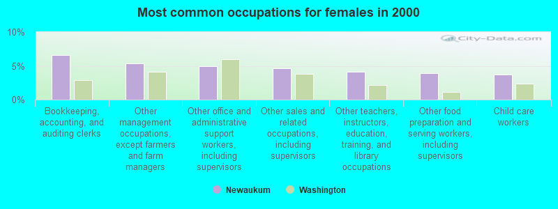
- Bookkeeping, accounting, and auditing clerks (6.6%)
- Other management occupations, except farmers and farm managers (5.4%)
- Other office and administrative support workers, including supervisors (4.9%)
- Other sales and related occupations, including supervisors (4.7%)
- Other teachers, instructors, education, training, and library occupations (4.2%)
- Other food preparation and serving workers, including supervisors (3.9%)
- Child care workers (3.7%)
Average climate in Newaukum, Washington
Based on data reported by over 4,000 weather stations


(lower is better)
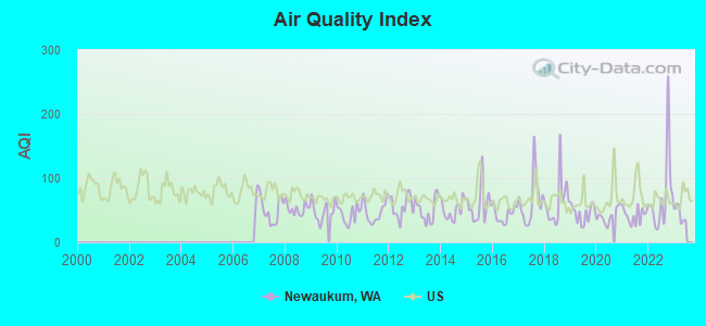
Air Quality Index (AQI) level in 2022 was 71.8. This is about average.
| City: | 71.8 |
| U.S.: | 72.6 |
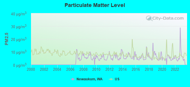
Particulate Matter (PM2.5) [µg/m3] level in 2022 was 7.91. This is about average. Closest monitor was 7.5 miles away from the city center.
| City: | 7.91 |
| U.S.: | 8.11 |
Earthquake activity:
Newaukum-area historical earthquake activity is significantly above Washington state average. It is 1430% greater than the overall U.S. average.On 4/13/1949 at 19:55:42, a magnitude 7.0 (7.0 UK, Class: Major, Intensity: VIII - XII) earthquake occurred 49.3 miles away from Newaukum center, causing $80,000,000 total damage
On 2/28/2001 at 18:54:32, a magnitude 6.8 (6.5 MB, 6.6 MS, 6.8 MW, Class: Strong, Intensity: VII - IX) earthquake occurred 37.7 miles away from the city center, causing $2,000,000,000 total damage and $305,000,000 insured losses
On 2/28/2001 at 18:54:32, a magnitude 6.8 (6.8 MD, Depth: 32.2 mi) earthquake occurred 38.9 miles away from the city center
On 4/29/1965 at 15:28:43, a magnitude 6.6 (6.6 UK) earthquake occurred 57.1 miles away from the city center, causing $28,000,000 total damage
On 7/3/1999 at 01:43:54, a magnitude 5.8 (5.4 MB, 5.5 MS, 5.8 MW, 5.3 ME, Depth: 25.2 mi, Class: Moderate, Intensity: VI - VII) earthquake occurred 33.7 miles away from Newaukum center
On 1/31/1922 at 13:17:28, a magnitude 7.6 (7.6 UK) earthquake occurred 428.8 miles away from the city center
Magnitude types: body-wave magnitude (MB), duration magnitude (MD), energy magnitude (ME), surface-wave magnitude (MS), moment magnitude (MW)
Natural disasters:
The number of natural disasters in Lewis County (29) is a lot greater than the US average (15).Major Disasters (Presidential) Declared: 26
Emergencies Declared: 1
Causes of natural disasters: Floods: 21, Storms: 15, Mudslides: 11, Landslides: 10, Winter Storms: 8, Winds: 4, Snows: 3, Heavy Rains: 2, Earthquake: 1, Hurricane: 1, Tornado: 1, Volcanic Eruption: 1, Other: 1 (Note: some incidents may be assigned to more than one category).
Hospitals and medical centers near Newaukum:
- FMC CHEHALIS (Dialysis Facility, about 4 miles away; CHEHALIS, WA)
- ST HELEN HOSP (Nursing Home, about 4 miles away; CHEHALIS, WA)
- SOUTH TOWER CARE CENTER (Nursing Home, about 7 miles away; CENTRALIA, WA)
- CENTRALIA CONVALESCENT CENTER (Nursing Home, about 7 miles away; CENTRALIA, WA)
- EVERGREEN CENTRALIA HEALTH AND R (Nursing Home, about 7 miles away; CENTRALIA, WA)
- PROVIDENCE CENTRALIA HOSPITAL Acute Care Hospitals (about 8 miles away; CENTRALIA, WA)
- LIBERTY CARE AND REHAB CENTER (Nursing Home, about 8 miles away; CENTRALIA, WA)
Colleges/universities with over 2000 students nearest to Newaukum:
- Centralia College (about 8 miles; Centralia, WA; Full-time enrollment: 2,354)
- South Puget Sound Community College (about 29 miles; Olympia, WA; FT enrollment: 3,981)
- The Evergreen State College (about 33 miles; Olympia, WA; FT enrollment: 4,613)
- Lower Columbia College (about 33 miles; Longview, WA; FT enrollment: 2,595)
- Pierce College at Fort Steilacoom (about 43 miles; Lakewood, WA; FT enrollment: 5,228)
- Pacific Lutheran University (about 45 miles; Tacoma, WA; FT enrollment: 3,548)
- Clover Park Technical College (about 45 miles; Lakewood, WA; FT enrollment: 4,185)
Points of interest:
Notable locations in Newaukum: Chehalis Substation (A), Newaukum Valley Golf Course (B), Lewis County Fire District 5 Station 2 (C). Display/hide their locations on the map
Creeks: Mill Creek (A), Stearns Creek (B). Display/hide their locations on the map
| This place: | 2.6 people |
| Washington: | 2.5 people |
| This place: | 70.6% |
| Whole state: | 66.5% |
| This place: | 5.1% |
| Whole state: | 6.1% |
Likely homosexual households (counted as self-reported same-sex unmarried-partner households)
- Lesbian couples: 0.2% of all households
- Gay men: 0.5% of all households
| This place: | 7.3% |
| Whole state: | 10.6% |
| This place: | 2.7% |
| Whole state: | 4.6% |
For population 15 years and over in Newaukum:
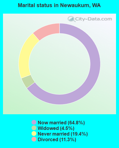
- Never married: 19.4%
- Now married: 64.8%
- Separated: 0.0%
- Widowed: 4.5%
- Divorced: 11.3%
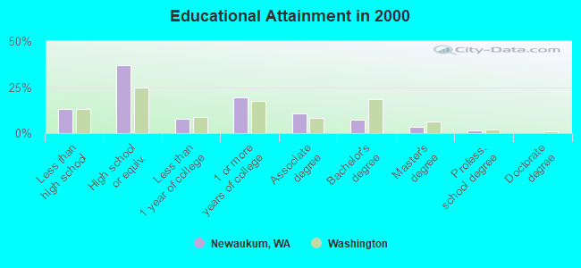
For population 25 years and over in Newaukum:
- High school or higher: 86.8%
- Bachelor's degree or higher: 12.2%
- Graduate or professional degree: 5.0%
- Unemployed: 6.2%
- Mean travel time to work (commute): 23.1 minutes
| Here: | 8.8 |
| Washington average: | 11.3 |
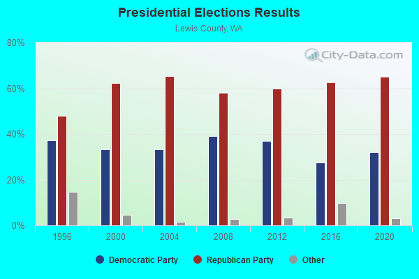
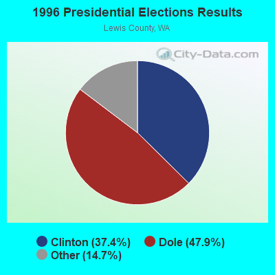

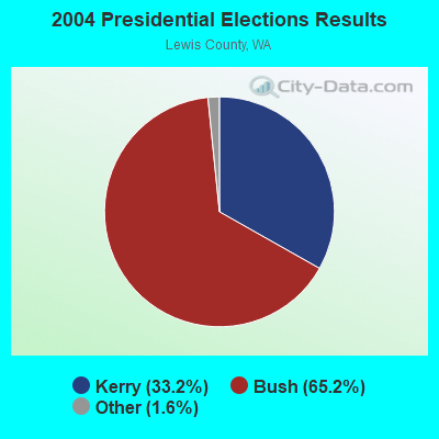
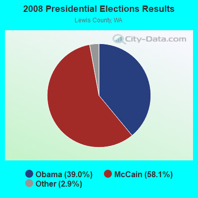
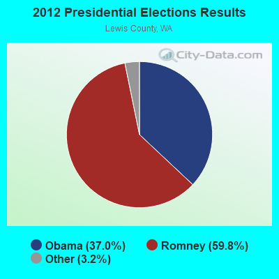
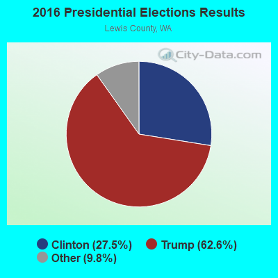
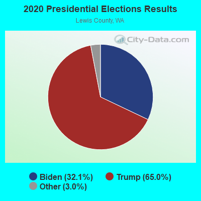
Graphs represent county-level data. Detailed 2008 Election Results
Religion statistics for Newaukum, WA (based on Lewis County data)
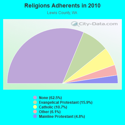
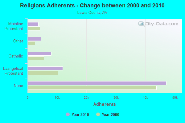
| Religion | Adherents | Congregations |
|---|---|---|
| Evangelical Protestant | 11,961 | 66 |
| Catholic | 8,102 | 10 |
| Other | 4,637 | 16 |
| Mainline Protestant | 3,621 | 20 |
| None | 47,134 | - |
Food Environment Statistics:
| Here: | 3.54 / 10,000 pop. |
| Washington: | 2.06 / 10,000 pop. |
| Lewis County: | 1.63 / 10,000 pop. |
| Washington: | 1.18 / 10,000 pop. |
| This county: | 5.17 / 10,000 pop. |
| Washington: | 2.67 / 10,000 pop. |
| Lewis County: | 8.16 / 10,000 pop. |
| Washington: | 8.26 / 10,000 pop. |
| Lewis County: | 9.8% |
| State: | 7.7% |
| This county: | 34.4% |
| State: | 25.7% |
| Lewis County: | 10.0% |
| State: | 13.9% |
Strongest AM radio stations in Newaukum:
- KELA (1470 AM; 5 kW; CENTRALIA-CHEHALIS, WA; Owner: CITICASTERS LICENSES, L.P.)
- KITI (1420 AM; 5 kW; CENTRALIA-CHEHALIS, WA; Owner: PREMIER BROADCASTERS, INC.)
- KJR (950 AM; 50 kW; SEATTLE, WA)
- KIRO (710 AM; 50 kW; SEATTLE, WA; Owner: ENTERCOM SEATTLE LICENSE, LLC)
- KTTH (770 AM; 50 kW; SEATTLE, WA; Owner: ENTERCOM SEATTLE LICENSE, LLC)
- KGNW (820 AM; 50 kW; BURIEN-SEATTLE, WA; Owner: INSPIRATION MEDIA, INC.)
- KYCW (1090 AM; 50 kW; SEATTLE, WA; Owner: INFINITY RADIO SUBSIDIARY OPERATIONS INC.)
- KOMO (1000 AM; 50 kW; SEATTLE, WA; Owner: FISHER BROADCASTING - SEATTLE RADIO, L.L.C.)
- KPAM (860 AM; 50 kW; TROUTDALE, OR; Owner: PAMPLIN BROADCASTING-OREGON, INC.)
- KPOJ (620 AM; 50 kW; PORTLAND, OR; Owner: CITICASTERS LICENSES, L.P.)
- KIXI (880 AM; 50 kW; MERCER ISLAND/SEATTL, WA; Owner: BELLEVUE RADIO, INC.)
- KXL (750 AM; 50 kW; PORTLAND, OR; Owner: ROSE CITY RADIO CORPORATION)
- KOTK (1080 AM; 50 kW; PORTLAND, OR; Owner: FISHER BROADCASTING - PORTLAND RADIO, L.L.C.)
Strongest FM radio stations in Newaukum:
- KMNT (102.9 FM; CENTRALIA, WA; Owner: CITICASTERS LICENSES, L.P.)
- K282AB (104.3 FM; CHEHALIS, WA; Owner: TWIN CITY GOSPEL ECHO)
- K220HE (91.9 FM; CHEHALIS, WA; Owner: CALVARY CHAPEL OF TWIN FALLS, INC.)
- KITI-FM (95.1 FM; WINLOCK, WA; Owner: PREMIER BROADCASTERS, INC.)
- KRQT (107.1 FM; CASTLE ROCK, WA; Owner: ENTERCOM LONGVIEW LICENSE, LLC)
- KXXO (96.1 FM; OLYMPIA, WA; Owner: 3 CITIES, INC.)
- KFMY (97.7 FM; RAYMOND, WA; Owner: SOUTH SOUND BROADCASTING, LLC)
- KACS (90.5 FM; CHEHALIS, WA; Owner: CHEHALIS VALLEY EDUCATIONAL FOUNDATION)
- K273AI (102.5 FM; ARIEL, WA; Owner: CALVARY CHAPEL OF TWIN FALLS, INC.)
- K216DH (91.1 FM; CATHLAMET, WA; Owner: TILLICUM FOUNDATION)
- KAYO-FM (99.3 FM; ELMA, WA; Owner: SOUTH SOUND BROADCASTING, LLC)
- KGY-FM (96.9 FM; MCCLEARY, WA; Owner: KGY, INC.)
- KUKN (105.5 FM; LONGVIEW, WA; Owner: WASHINGTON INTERSTATE BROADCASTING, INC.)
- KWYQ (90.3 FM; LONGVIEW, WA; Owner: WAY-FM MEDIA GROUP, INC.)
- KRXY (94.5 FM; SHELTON, WA; Owner: PREMIER BROADCASTERS, INC.)
- KJET (105.7 FM; SOUTH BEND, WA; Owner: JODESHA BROADCASTING, INC.)
- KJVH (89.5 FM; LONGVIEW, WA; Owner: FAMILY STATIONS, INC.)
- KLYK (94.5 FM; KELSO, WA; Owner: ENTERCOM LONGVIEW LICENSE, LLC)
- K211AP (90.1 FM; CENTRALIA, WA; Owner: PACIFIC LUTHERAN UNIVERSITY, INC.)
- KCED (91.3 FM; CENTRALIA, WA; Owner: STATE OF WASH. CENTRALIA COLLEGE)
TV broadcast stations around Newaukum:
- KCKA (Channel 15; CENTRALIA, WA; Owner: BATES TECHNICAL COLLEGE)
- K42CM (Channel 42; CENTRALIA, ETC., WA; Owner: TRIBUNE TELEVISION NORTHWEST, INC.)
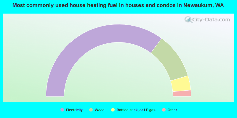
- 70.2%Electricity
- 20.4%Wood
- 6.5%Bottled, tank, or LP gas
- 1.6%Other fuel
- 1.2%Utility gas
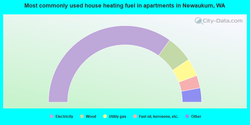
- 69.9%Electricity
- 11.3%Wood
- 7.5%Utility gas
- 5.3%Fuel oil, kerosene, etc.
- 3.8%No fuel used
- 2.3%Bottled, tank, or LP gas
Newaukum compared to Washington state average:
- Unemployed percentage below state average.
- Black race population percentage significantly below state average.
- Hispanic race population percentage significantly below state average.
- Median age above state average.
- Foreign-born population percentage significantly below state average.
- Renting percentage significantly below state average.
- Length of stay since moving in significantly above state average.
- Number of rooms per house significantly below state average.
- House age significantly below state average.
- Percentage of population with a bachelor's degree or higher significantly below state average.