Niles, New York
Submit your own pictures of this town and show them to the world
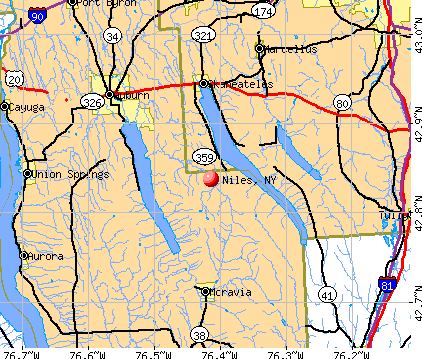
- OSM Map
- General Map
- Google Map
- MSN Map
Population change since 2000: -1.2%
 |
| Males: 630 | |
| Females: 564 |
| Median resident age: | 45.6 years |
| New York median age: | 40.7 years |
Zip codes: 13118.
| Niles: | $72,025 |
| NY: | $79,557 |
Estimated per capita income in 2022: $40,865 (it was $20,791 in 2000)
Niles town income, earnings, and wages data
Estimated median house or condo value in 2022: $207,953 (it was $91,600 in 2000)
| Niles: | $207,953 |
| NY: | $400,400 |
Mean prices in 2022: all housing units: $208,264; detached houses: $225,118; townhouses or other attached units: $236,740; in 2-unit structures: $244,571; in 3-to-4-unit structures: $414,744; in 5-or-more-unit structures: $633,100; mobile homes: $69,131
Detailed information about poverty and poor residents in Niles, NY


- 1,15897.0%White alone
- 141.2%Two or more races
- 100.8%Black alone
- 70.6%Hispanic
- 40.3%Asian alone
- 10.08%American Indian alone
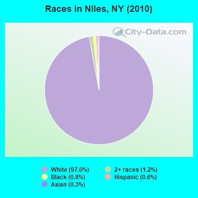
Races in Niles detailed stats: ancestries, foreign born residents, place of birth
 Recent articles from our blog. Our writers, many of them Ph.D. graduates or candidates, create easy-to-read articles on a wide variety of topics.


Latest news from Niles, NY collected exclusively by city-data.com from local newspapers, TV, and radio stations
Ancestries: English (23.6%), Irish (22.9%), German (18.1%), Dutch (7.3%), Italian (6.4%), United States (6.0%).
Current Local Time: EST time zone
Land area: 39.1 square miles.
Population density: 31 people per square mile (very low).
20 residents are foreign born
| This town: | 1.7% |
| New York: | 20.4% |
| Niles town: | 1.9% ($1,705) |
| New York: | 1.9% ($2,847) |
Nearest city with pop. 50,000+: Syracuse, NY  (21.0 miles , pop. 147,306).
Nearest city with pop. 200,000+: Rochester, NY (65.2 miles , pop. 219,773).
Nearest city with pop. 1,000,000+: Bronx, NY (188.9 miles , pop. 1,332,650).
Nearest cities:
), ), ), ), ), Latitude: 42.82 N, Longitude: 76.41 W
Area code commonly used in this area: 315
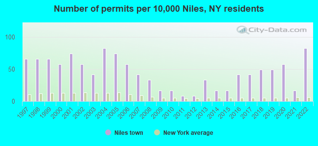
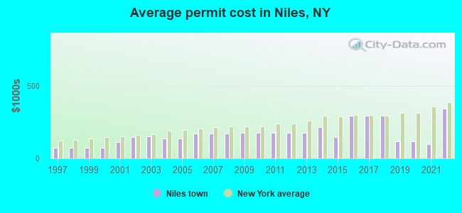
Single-family new house construction building permits:
- 2022: 10 buildings, average cost: $343,700
- 2021: 2 buildings, average cost: $97,500
- 2020: 7 buildings, average cost: $116,800
- 2019: 6 buildings, average cost: $116,800
- 2018: 6 buildings, average cost: $293,100
- 2017: 5 buildings, average cost: $293,100
- 2016: 5 buildings, average cost: $293,100
- 2015: 2 buildings, average cost: $145,000
- 2014: 2 buildings, average cost: $214,500
- 2013: 4 buildings, average cost: $174,800
- 2012: 1 building, cost: $175,000
- 2011: 1 building, cost: $175,000
- 2010: 2 buildings, average cost: $175,000
- 2009: 2 buildings, average cost: $175,000
- 2008: 4 buildings, average cost: $171,000
- 2007: 5 buildings, average cost: $171,000
- 2006: 7 buildings, average cost: $171,000
- 2005: 9 buildings, average cost: $138,800
- 2004: 10 buildings, average cost: $138,800
- 2003: 5 buildings, average cost: $153,100
- 2002: 7 buildings, average cost: $147,500
- 2001: 9 buildings, average cost: $112,200
- 2000: 7 buildings, average cost: $73,400
- 1999: 8 buildings, average cost: $73,400
- 1998: 8 buildings, average cost: $73,400
- 1997: 8 buildings, average cost: $73,400
| Here: | 4.2% |
| New York: | 4.4% |
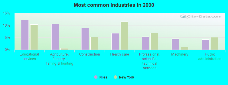
- Educational services (12.2%)
- Agriculture, forestry, fishing & hunting (10.6%)
- Construction (8.9%)
- Health care (6.7%)
- Professional, scientific, technical services (5.4%)
- Machinery (4.5%)
- Public administration (4.2%)
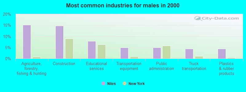
- Agriculture, forestry, fishing & hunting (15.1%)
- Construction (14.8%)
- Educational services (7.8%)
- Transportation equipment (4.9%)
- Public administration (4.9%)
- Truck transportation (4.4%)
- Plastics & rubber products (4.4%)
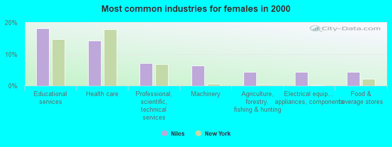
- Educational services (18.2%)
- Health care (14.2%)
- Professional, scientific, technical services (7.1%)
- Machinery (6.3%)
- Agriculture, forestry, fishing & hunting (4.3%)
- Electrical equipment, appliances, components (4.3%)
- Food & beverage stores (4.3%)
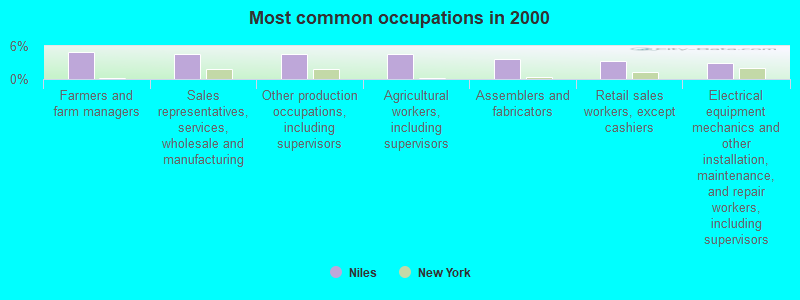
- Farmers and farm managers (4.9%)
- Sales representatives, services, wholesale and manufacturing (4.5%)
- Other production occupations, including supervisors (4.5%)
- Agricultural workers, including supervisors (4.5%)
- Assemblers and fabricators (3.7%)
- Retail sales workers, except cashiers (3.2%)
- Electrical equipment mechanics and other installation, maintenance, and repair workers, including supervisors (2.8%)

- Farmers and farm managers (7.8%)
- Agricultural workers, including supervisors (5.8%)
- Other production occupations, including supervisors (5.8%)
- Sales representatives, services, wholesale and manufacturing (5.2%)
- Top executives (4.9%)
- Assemblers and fabricators (4.4%)
- Electrical equipment mechanics and other installation, maintenance, and repair workers, including supervisors (4.4%)
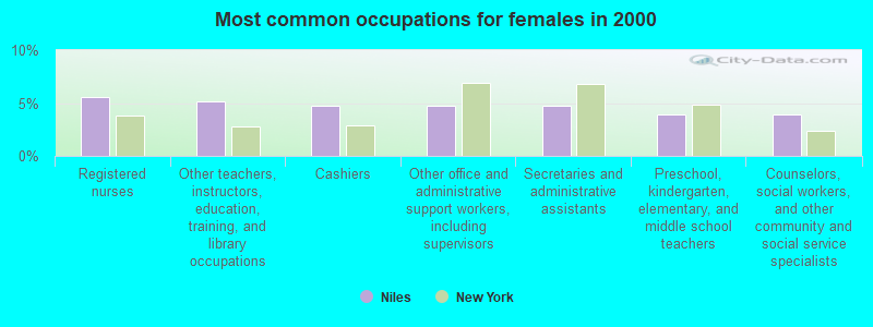
- Registered nurses (5.5%)
- Other teachers, instructors, education, training, and library occupations (5.1%)
- Cashiers (4.7%)
- Other office and administrative support workers, including supervisors (4.7%)
- Secretaries and administrative assistants (4.7%)
- Preschool, kindergarten, elementary, and middle school teachers (4.0%)
- Counselors, social workers, and other community and social service specialists (4.0%)
Average climate in Niles, New York
Based on data reported by over 4,000 weather stations


(lower is better)
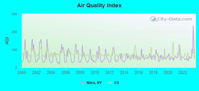
Air Quality Index (AQI) level in 2023 was 92.0. This is worse than average.
| City: | 92.0 |
| U.S.: | 72.6 |
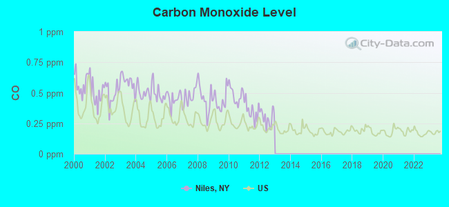
Carbon Monoxide (CO) [ppm] level in 2012 was 0.295. This is about average. Closest monitor was 20.9 miles away from the city center.
| City: | 0.295 |
| U.S.: | 0.251 |

Sulfur Dioxide (SO2) [ppb] level in 2021 was 0.128. This is significantly better than average. Closest monitor was 10.9 miles away from the city center.
| City: | 0.128 |
| U.S.: | 1.515 |
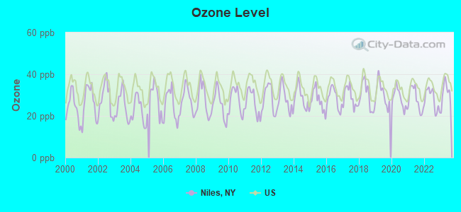
Ozone [ppb] level in 2023 was 30.9. This is about average. Closest monitor was 20.9 miles away from the city center.
| City: | 30.9 |
| U.S.: | 33.3 |
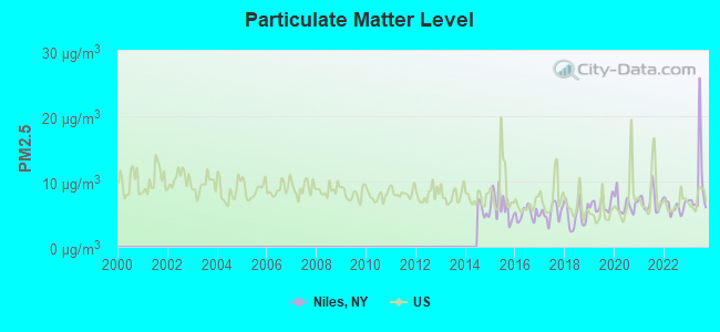
Particulate Matter (PM2.5) [µg/m3] level in 2023 was 9.42. This is about average. Closest monitor was 19.1 miles away from the city center.
| City: | 9.42 |
| U.S.: | 8.11 |
Tornado activity:
Niles-area historical tornado activity is below New York state average. It is 74% smaller than the overall U.S. average.
On 5/2/1983, a category F3 (max. wind speeds 158-206 mph) tornado 26.6 miles away from the Niles town center killed one person and caused between $500,000 and $5,000,000 in damages.
On 5/2/1983, a category F3 tornado 29.2 miles away from the town center caused between $50,000 and $500,000 in damages.
Earthquake activity:
Niles-area historical earthquake activity is significantly above New York state average. It is 67% smaller than the overall U.S. average.On 10/7/1983 at 10:18:46, a magnitude 5.3 (5.1 MB, 5.3 LG, 5.1 ML, Class: Moderate, Intensity: VI - VII) earthquake occurred 130.5 miles away from the city center
On 4/20/2002 at 10:50:47, a magnitude 5.3 (5.3 ML, Depth: 3.0 mi) earthquake occurred 179.6 miles away from Niles center
On 4/20/2002 at 10:50:47, a magnitude 5.2 (5.2 MB, 4.2 MS, 5.2 MW, 5.0 MW) earthquake occurred 177.7 miles away from Niles center
On 9/25/1998 at 19:52:52, a magnitude 5.2 (4.8 MB, 4.3 MS, 5.2 LG, 4.5 MW, Depth: 3.1 mi) earthquake occurred 223.7 miles away from Niles center
On 8/23/2011 at 17:51:04, a magnitude 5.8 (5.8 MW, Depth: 3.7 mi) earthquake occurred 348.7 miles away from the city center
On 1/16/1994 at 01:49:16, a magnitude 4.6 (4.6 MB, 4.6 LG, Depth: 3.1 mi, Class: Light, Intensity: IV - V) earthquake occurred 173.0 miles away from Niles center
Magnitude types: regional Lg-wave magnitude (LG), body-wave magnitude (MB), local magnitude (ML), surface-wave magnitude (MS), moment magnitude (MW)
Natural disasters:
The number of natural disasters in Cayuga County (15) is near the US average (15).Major Disasters (Presidential) Declared: 8
Emergencies Declared: 6
Causes of natural disasters: Floods: 5, Storms: 4, Hurricanes: 2, Blizzard: 1, Heavy Rain: 1, Ice Storm: 1, Landslide: 1, Power Outage: 1, Snow: 1, Tropical Storm: 1, Wind: 1, Other: 2 (Note: some incidents may be assigned to more than one category).
Hospitals and medical centers near Niles:
- AUBURN NURSING HOME (Nursing Home, about 11 miles away; AUBURN, NY)
- MERCY HEALTH AND REHAB CENTER N H INC (Nursing Home, about 11 miles away; AUBURN, NY)
- CAYUGA COUNTY CHHA (Home Health Center, about 12 miles away; AUBURN, NY)
- UNIV DIALYSIS CTR @ AUBURN (Dialysis Facility, about 12 miles away; AUBURN, NY)
- AUBURN COMMUNITY HOSPITAL Acute Care Hospitals (about 12 miles away; AUBURN, NY)
- FINGER LAKES CENTER FOR LIVING (Nursing Home, about 12 miles away; AUBURN, NY)
- CAYUGA COUNTY NURSING HOME (Nursing Home, about 13 miles away; AUBURN, NY)
Colleges/universities with over 2000 students nearest to Niles:
- Cayuga County Community College (about 11 miles; Auburn, NY; Full-time enrollment: 3,141)
- Onondaga Community College (about 18 miles; Syracuse, NY; FT enrollment: 8,920)
- SUNY College at Cortland (about 20 miles; Cortland, NY; FT enrollment: 6,838)
- SUNY College of Environmental Science and Forestry (about 21 miles; Syracuse, NY; FT enrollment: 2,044)
- Syracuse University (about 21 miles; Syracuse, NY; FT enrollment: 20,717)
- Tompkins Cortland Community College (about 23 miles; Dryden, NY; FT enrollment: 3,884)
- Le Moyne College (about 24 miles; Syracuse, NY; FT enrollment: 3,041)
Points of interest:
Notable locations in Niles: Twelve Corners (A), Folls Flower Farm (B), New Hope Fire Department (C), West Niles Fire Department (D). Display/hide their locations on the map
Church in Niles: Mid - Lakes United Methodist Church (A). Display/hide its location on the map
Cemeteries: James Cemetery (1), New Hope Cemetery (2), Twelve Corners Cemetery (3), West Niles Rural Cemetery (4), Conklin Cemetery (5). Display/hide their locations on the map
Reservoir: Owasco Lake (A). Display/hide its location on the map
Streams, rivers, and creeks: Fall Brook (A), Bear Swamp Creek (B). Display/hide their locations on the map
| This town: | 2.5 people |
| New York: | 2.6 people |
| This town: | 75.2% |
| Whole state: | 63.5% |
| This town: | 9.5% |
| Whole state: | 6.8% |
Likely homosexual households (counted as self-reported same-sex unmarried-partner households)
- Lesbian couples: 1.1% of all households
- Gay men: 0.2% of all households
| This town: | 7.5% |
| Whole state: | 14.6% |
| This town: | 2.8% |
| Whole state: | 7.4% |
For population 15 years and over in Niles:
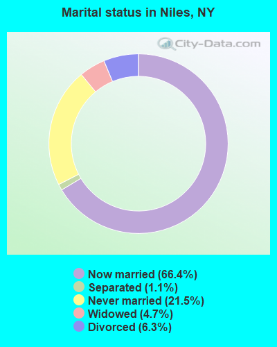
- Never married: 21.5%
- Now married: 66.4%
- Separated: 1.1%
- Widowed: 4.7%
- Divorced: 6.3%
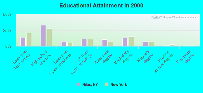
For population 25 years and over in Niles:
- High school or higher: 85.8%
- Bachelor's degree or higher: 23.0%
- Graduate or professional degree: 9.7%
- Unemployed: 4.3%
- Mean travel time to work (commute): 28.0 minutes
| Here: | 10.0 |
| New York average: | 14.2 |
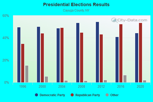
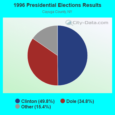
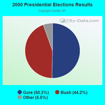
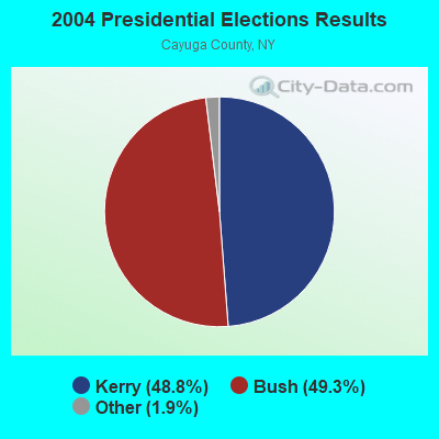
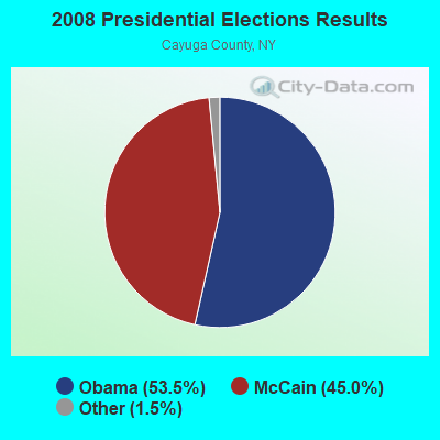
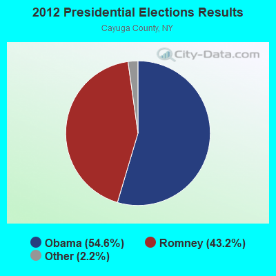
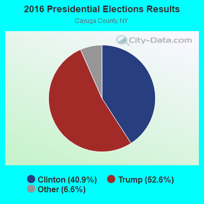
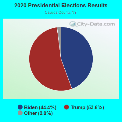
Graphs represent county-level data. Detailed 2008 Election Results
Religion statistics for Niles, NY (based on Cayuga County data)
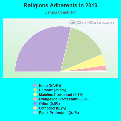
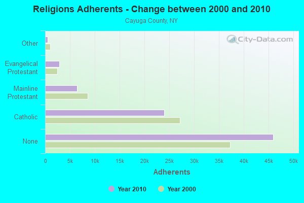
| Religion | Adherents | Congregations |
|---|---|---|
| Catholic | 23,937 | 10 |
| Mainline Protestant | 6,462 | 38 |
| Evangelical Protestant | 2,886 | 31 |
| Other | 502 | 5 |
| Orthodox | 150 | 1 |
| Black Protestant | 119 | 1 |
| None | 45,970 | - |
Food Environment Statistics:
| Cayuga County: | 2.12 / 10,000 pop. |
| New York: | 4.13 / 10,000 pop. |
| Here: | 0.25 / 10,000 pop. |
| State: | 0.06 / 10,000 pop. |
| Cayuga County: | 0.50 / 10,000 pop. |
| State: | 0.92 / 10,000 pop. |
| This county: | 3.50 / 10,000 pop. |
| State: | 1.68 / 10,000 pop. |
| Here: | 7.25 / 10,000 pop. |
| New York: | 8.82 / 10,000 pop. |
| Cayuga County: | 8.0% |
| State: | 8.2% |
| Here: | 25.6% |
| New York: | 23.8% |
| Cayuga County: | 12.2% |
| New York: | 15.6% |
Strongest AM radio stations in Niles:
- WSYR (570 AM; 5 kW; SYRACUSE, NY; Owner: CLEAR CHANNEL BROADCASTING LICENSES, INC.)
- WHEN (620 AM; 5 kW; SYRACUSE, NY; Owner: CLEAR CHANNEL BROADCASTING LICENSES, INC.)
- WHCU (870 AM; 5 kW; ITHACA, NY; Owner: EAGLE BROADCASTING COMPANY, INC.)
- WHAM (1180 AM; 50 kW; ROCHESTER, NY; Owner: CITICASTERS LICENSES, L.P.)
- WNSS (1260 AM; 5 kW; SYRACUSE, NY; Owner: CITADEL BROADCASTING COMPANY)
- WPIE (1160 AM; 5 kW; TRUMANSBURG, NY; Owner: PEMBROOK PINES ITHACA LTD. N.A.)
- WSIV (1540 AM; 2 kW; E. SYRACUSE, NY; Owner: CRAM COMMUNICATIONS LLC)
- WDCW (1390 AM; 5 kW; SYRACUSE, NY; Owner: KIMTRON, INC.)
- WAUB (1590 AM; 1 kW; AUBURN, NY; Owner: AUBURN BROADCASTING, INC.)
- WWLF (1340 AM; 1 kW; AUBURN, NY; Owner: WOLF RADIO, INC)
- WGY (810 AM; 50 kW; SCHENECTADY, NY; Owner: CLEAR CHANNEL BROADCASTING LICENSES, INC.)
- WTKO (1470 AM; 5 kW; ITHACA, NY; Owner: EAGLE II BROADCASTING CORPORATION)
- WFBL (1050 AM; 2 kW; BALDWINSVILLE, NY; Owner: BUCKLEY BROADCASTING CORPORATION)
Strongest FM radio stations in Niles:
- WPHR (106.9 FM; AUBURN, NY; Owner: CLEAR CHANNEL BROADCASTING LICENSES, INC.)
- WMHR (102.9 FM; SYRACUSE, NY; Owner: MARS HILL BROADCASTING CO., INC.)
- W251AK (98.1 FM; NEDROW, NY; Owner: PATHWAY COMMUNITY RADIO, INC.)
- WXHC (101.5 FM; HOMER, NY; Owner: EVES BROADCASTING, INC.)
- WYYY (94.5 FM; SYRACUSE, NY; Owner: CLEAR CHANNEL BROADCASTING LICENSES, INC.)
- WYXL (97.3 FM; ITHACA, NY; Owner: EAGLE BROADCASTING COMPANY)
- WCNY-FM (91.3 FM; SYRACUSE, NY; Owner: THE PUB. B/C COUNC. OF CEN. NY, INC.)
- WIII (99.9 FM; CORTLAND, NY; Owner: CITADEL BROADCASTING COMPANY)
- WNTQ (93.1 FM; SYRACUSE, NY; Owner: CITADEL BROADCASTING COMPANY)
- W278AH (103.5 FM; SYRACUSE, JAMESVILLE, NY; Owner: CALVARY CHAPEL OF THE FINGER LAKES, INC.)
- WWHT (107.9 FM; SYRACUSE, NY; Owner: CLEAR CHANNEL BROADCASTING LICENSES, INC.)
- WQNY (103.7 FM; ITHACA, NY; Owner: EAGLE II BROADCASTING CORPORATION)
- WNYR-FM (98.5 FM; WATERLOO, NY; Owner: LAKE COUNTRY BROADCASTING, INC.)
- WSQG-FM (90.9 FM; ITHACA, NY; Owner: WSKG PUBLIC TELECOMM. COUNCIL)
- WLLW (99.3 FM; SENECA FALLS, NY; Owner: AUBURN BROADCASTING, INC.)
- WWDG (105.1 FM; DERUYTER, NY; Owner: CLEAR CHANNEL BROADCASTING LICENSES, INC.)
- WFLK (101.7 FM; GENEVA, NY; Owner: MB COMMUNICATIONS, INC.)
- WBBS (104.7 FM; FULTON, NY; Owner: CITICASTERS LICENSES, L.P.)
- WLTI (105.9 FM; SYRACUSE, NY; Owner: CITADEL BROADCASTING COMPANY)
- WZUN (102.1 FM; PHOENIX, NY; Owner: GALAXY COMMUNICATIONS, L.P.)
TV broadcast stations around Niles:
- WSYT (Channel 68; SYRACUSE, NY; Owner: WSYT LICENSEE L.P.)
- WCNY-TV (Channel 24; SYRACUSE, NY; Owner: PUBLIC BROADCASTING COUNCIL OF CENTRAL NEW YORK)
- WSTM-TV (Channel 3; SYRACUSE, NY; Owner: WSTM LICENSE SUBSIDIARY, INC.)
- WIXT-TV (Channel 9; SYRACUSE, NY; Owner: CENTRAL NY NEWS, INC.)
- WNYS-TV (Channel 43; SYRACUSE, NY; Owner: RKM MEDIA, INC.)
- WTVH (Channel 5; SYRACUSE, NY; Owner: WTVH LICENSE, INC.)
- W48AO (Channel 48; AUBURN, NY; Owner: SONNY PERSAD)
- W11BP (Channel 11; SYRACUSE, ETC., NY; Owner: RENARD COMMUNICATIONS CORP.)
- WSPX-TV (Channel 56; SYRACUSE, NY; Owner: PAXSON SYRACUSE LICENSE, INC.)
- W51BA (Channel 51; SYRACUSE, NY; Owner: RENARD COMMUNICATIONS CORP.)
- W54AK (Channel 54; AUBURN, NY; Owner: SONNY PERSAD)
- WTVU-LP (Channel 22; SYRACUSE, NY; Owner: RENARD COMMUNICATIONS CORP.)
- WOBX-LP (Channel 35; SYRACUSE, NY; Owner: METRO TV, INC.)
- WBLZ-LP (Channel 13; SYRACUSE, NY; Owner: RENARD COMMUNICATIONS CORP.)
- WSTQ-LP (Channel 14; SYRACUSE, NY; Owner: FEDERAL BROADCASTING COMPANY)
- WMBO-LP (Channel 60; SYRACUSE, ETC., NY; Owner: METRO TV, INC.)
- W30AJ (Channel 30; SYRACUSE, NY; Owner: JOHN MESTER INCOME FAMILY TRUST)
- WNDR-LP (Channel 18; SYRACUSE, NY; Owner: METRO TV, INC.)
- W40BJ (Channel 40; DEWITT, NY; Owner: RENARD COMMUNICATIONS CORP.)
- W38CY (Channel 38; SYRACUSE, NY; Owner: NATIONAL MINORITY T.V., INC.)
- W20BT (Channel 20; ITHACA, NY; Owner: NATIONAL MINORITY T.V., INC.)
- National Bridge Inventory (NBI) Statistics
- 2Number of bridges
- 10ft / 2.6mTotal length
- $1,047,000Total costs
- 182Total average daily traffic
- 12Total average daily truck traffic
- 255Total future (year 2038) average daily traffic
FCC Registered Antenna Towers:
1- Quarry Rd (Lat: 42.799444 Lon: -76.433611), Type: 48.0, Overall height: 42 m, Registrant: Finger Lakes Communication Co Inc, Flccaub@aol.Com, , Aubur-n, Phone: (315) 252-9478
FCC Registered Broadcast Land Mobile Towers:
7- Frozen Ocean Quarry Rd (Lat: 42.799500 Lon: -76.433556), Call Sign: KNGG341,
Assigned Frequencies: 46.5200 MHz, 46.5600 MHz, Grant Date: 01/10/2023, Expiration Date: 04/05/2033, Registrant: New York State Department Of Transportation, 50 Wolf Road Pod 5-3, Albany, NY 12232, Phone: (518) 457-1584, Email:
- Quarry Rd (Lat: 42.799167 Lon: -76.434722), Type: Tower, Structure height: 60.9 m, Call Sign: KA90076,
Assigned Frequencies: 151.452 MHz, Grant Date: 12/14/2005, Expiration Date: 12/19/2015, Cancellation Date: 02/20/2016, Registrant: Lao # 20333006, 102 E Middle St, Gettysburg, PA 17325, Phone: (800) 886-4222, Fax: (717) 337-9157, Email:
- Frozen Ocean Quarry Rd (Lat: 42.799500 Lon: -76.433556), Call Sign: KED915,
Assigned Frequencies: 154.695 MHz, 155.370 MHz, 155.475 MHz, 155.625 MHz, 42.1400 MHz, 154.695 MHz, 154.905 MHz, 155.370 MHz, 155.475 MHz, 155.625 MHz, Grant Date: 11/18/2021, Expiration Date: 02/02/2032, Registrant: New York State Police, 1220 Washington Ave, Bldg 22, Albany, NY 12226-2252, Phone: (518) 457-9466, Fax: (518) 457-5676, Email:
- Quarry Rd (Lat: 42.797833 Lon: -76.435778), Structure height: 40 m, Call Sign: WXV271, Licensee ID: L00802825,
Assigned Frequencies: 461.925 MHz, Grant Date: 01/24/2004, Expiration Date: 01/27/2014, Cancellation Date: 03/29/2014, Registrant: Schmidt Trucking Inc, 3702 Ny Rt 31, Liverpool, NY 13088, Phone: (315) 652-7776
- FO, Quarry Rd (Lat: 42.799611 Lon: -76.434333), Type: Gtower, Structure height: 55 m, Overall height: 60.6 m, Call Sign: WQXA818,
Assigned Frequencies: 155.752 MHz, 453.412 MHz, 151.137 MHz, 453.462 MHz, 154.452 MHz, 453.712 MHz, 158.737 MHz, 453.862 MHz, 159.472 MHz, Grant Date: 01/15/2016, Expiration Date: 01/15/2026, Cancellation Date: 01/17/2017, Certifier: Denise Spingler, Registrant: Rinehart Spectrum Solutions Group, LLC, 28 Twin Lakes Drive, Gettysburg, PA 17325, Phone: (717) 334-0654, Email:
- FO, Quarry Rd (Lat: 42.799611 Lon: -76.434333), Type: Gtower, Structure height: 55 m, Overall height: 60.6 m, Call Sign: WQXC838,
Assigned Frequencies: 851.012 MHz, 851.512 MHz, 852.012 MHz, 852.512 MHz, 853.012 MHz, Grant Date: 02/02/2016, Expiration Date: 02/02/2026, Cancellation Date: 01/17/2017, Certifier: Denise Spingler, Registrant: Rinehart Spectrum Solutions Group, LLC, 28 Twin Lakes Drive, Gettysburg, PA 17325, Phone: (717) 334-0654, Email:
- LOCATION 1, Frozen Oceans 3749 Quarry Hill Rd (Lat: 42.799500 Lon: -76.433556), Type: Gtower, Structure height: 33.5 m, Overall height: 39 m, Call Sign: WQYU866,
Assigned Frequencies: 155.625 MHz, 155.625 MHz, Grant Date: 01/27/2017, Expiration Date: 01/27/2027, Certifier: Charles L White Ii, Registrant: New York State Police, 1220 Washington Ave, Bldg 22, Albany, NY 12226-2252, Phone: (518) 457-9466, Fax: (518) 457-5676, Email:
FCC Registered Microwave Towers:
11 (See the full list of FCC Registered Microwave Towers in this town)FCC Registered Paging Towers:
2 (See the full list of FCC Registered Paging Towers)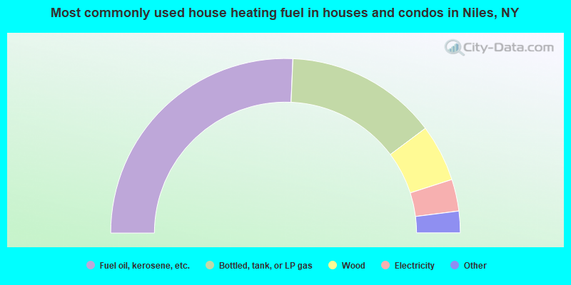
- 51.4%Fuel oil, kerosene, etc.
- 28.2%Bottled, tank, or LP gas
- 10.6%Wood
- 5.9%Electricity
- 1.2%Utility gas
- 1.2%Other fuel
- 0.7%Solar energy
- 0.5%Coal or coke
- 0.5%No fuel used
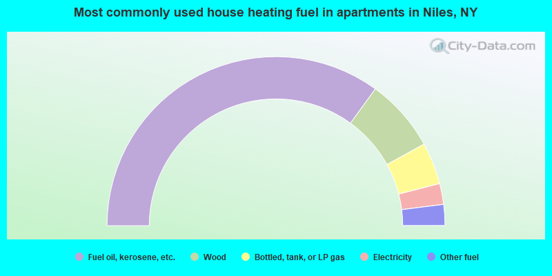
- 70.0%Fuel oil, kerosene, etc.
- 14.0%Wood
- 8.0%Bottled, tank, or LP gas
- 4.0%Electricity
- 4.0%Other fuel
Niles compared to New York state average:
- Median house value below state average.
- Unemployed percentage significantly below state average.
- Black race population percentage significantly below state average.
- Hispanic race population percentage significantly below state average.
- Median age above state average.
- Foreign-born population percentage significantly below state average.
- Renting percentage significantly below state average.
- Length of stay since moving in significantly above state average.
- Number of rooms per house significantly below state average.
- House age significantly below state average.
- Number of college students below state average.