North Harding, New Mexico
Submit your own pictures of this place and show them to the world
- OSM Map
- General Map
- Google Map
- MSN Map

| Males: 316 | |
| Females: 312 |
| Median resident age: | 49.4 years |
| New Mexico median age: | 34.6 years |
Zip code: 87743
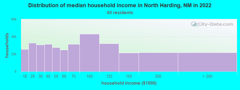
| North Harding: | $42,685 |
| NM: | $59,726 |
Estimated per capita income in 2022: $73,055 (it was $16,636 in 2000)
North Harding CCD income, earnings, and wages data
Estimated median house or condo value in 2022: $102,158 (it was $30,700 in 2000)
| North Harding: | $102,158 |
| NM: | $243,100 |
Mean prices in 2022: all housing units: $179,026; detached houses: $231,125; mobile homes: $35,594
Detailed information about poverty and poor residents in North Harding, NM


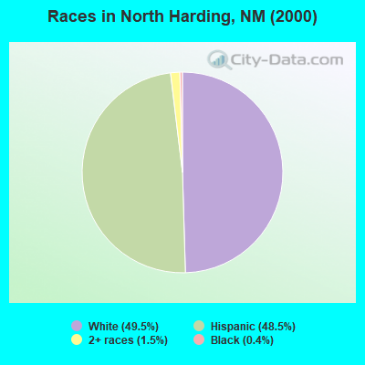
- 35249.5%White alone
- 34548.5%Hispanic
- 111.5%Two or more races
- 30.4%Black alone
Races in North Harding detailed stats: ancestries, foreign born residents, place of birth
 Recent articles from our blog. Our writers, many of them Ph.D. graduates or candidates, create easy-to-read articles on a wide variety of topics.

Current Local Time: MST time zone
Land area: 1164.6 square miles.
Population density: 0.5 people per square mile (very low).

| North Harding CCD: | 0.6% ($199) |
| New Mexico: | 0.7% ($699) |
Nearest city with pop. 50,000+: Santa Fe, NM  (110.8 miles , pop. 62,203).
Nearest city with pop. 200,000+: Albuquerque, NM (157.7 miles , pop. 448,607).
Nearest city with pop. 1,000,000+: Dallas, TX (469.3 miles , pop. 1,188,580).
Nearest cities:
), ), Latitude: 36.01 N, Longitude: 104.04 W
Area code commonly used in this area: 505

| Here: | 3.2% |
| New Mexico: | 3.6% |
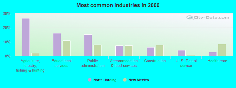
- Agriculture, forestry, fishing & hunting (26.7%)
- Educational services (16.2%)
- Public administration (15.3%)
- Accommodation & food services (7.5%)
- Construction (6.3%)
- U. S. Postal service (4.2%)
- Health care (3.0%)
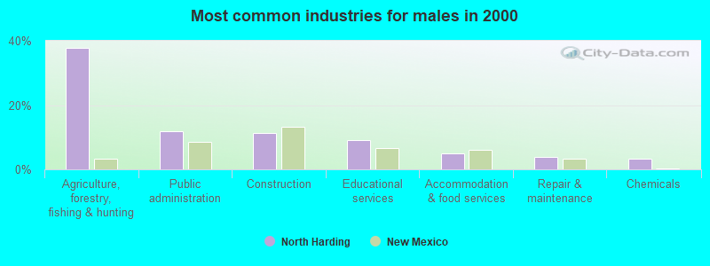
- Agriculture, forestry, fishing & hunting (37.8%)
- Public administration (11.9%)
- Construction (11.4%)
- Educational services (9.2%)
- Accommodation & food services (4.9%)
- Repair & maintenance (3.8%)
- Chemicals (3.2%)
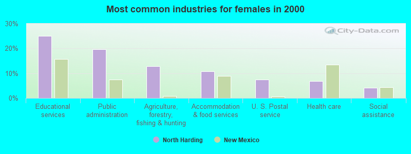
- Educational services (25.0%)
- Public administration (19.6%)
- Agriculture, forestry, fishing & hunting (12.8%)
- Accommodation & food services (10.8%)
- U. S. Postal service (7.4%)
- Health care (6.8%)
- Social assistance (4.1%)
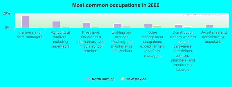
- Farmers and farm managers (16.8%)
- Agricultural workers, including supervisors (9.0%)
- Preschool, kindergarten, elementary, and middle school teachers (7.5%)
- Building and grounds cleaning and maintenance occupations (5.7%)
- Other management occupations, except farmers and farm managers (5.4%)
- Construction traders workers except carpenters, electricians, painters, plumbers, and construction laborers (4.5%)
- Secretaries and administrative assistants (3.6%)
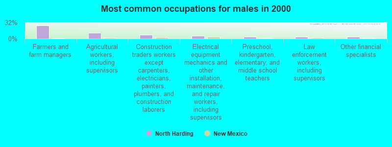
- Farmers and farm managers (25.9%)
- Agricultural workers, including supervisors (11.4%)
- Construction traders workers except carpenters, electricians, painters, plumbers, and construction laborers (8.1%)
- Electrical equipment mechanics and other installation, maintenance, and repair workers, including supervisors (5.4%)
- Preschool, kindergarten, elementary, and middle school teachers (3.8%)
- Law enforcement workers, including supervisors (3.8%)
- Other financial specialists (3.8%)
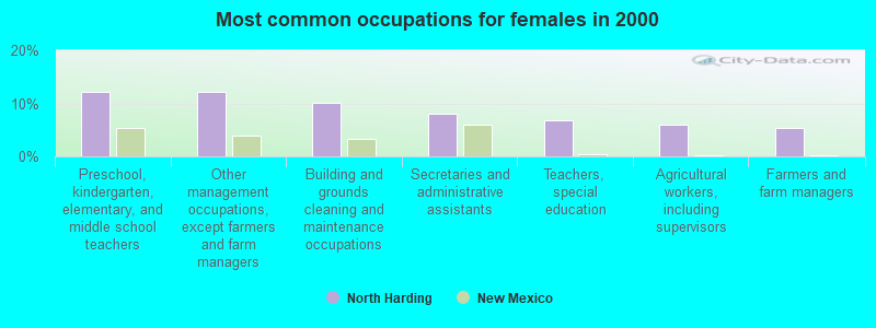
- Preschool, kindergarten, elementary, and middle school teachers (12.2%)
- Other management occupations, except farmers and farm managers (12.2%)
- Building and grounds cleaning and maintenance occupations (10.1%)
- Secretaries and administrative assistants (8.1%)
- Teachers, special education (6.8%)
- Agricultural workers, including supervisors (6.1%)
- Farmers and farm managers (5.4%)
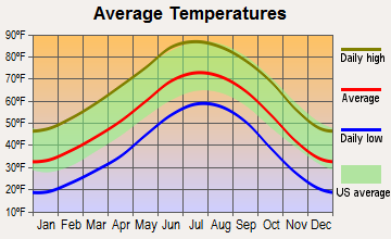
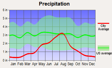
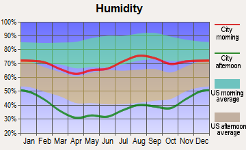
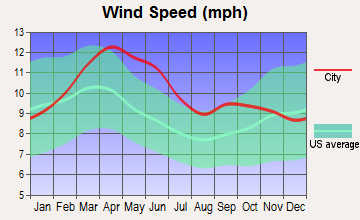
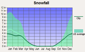
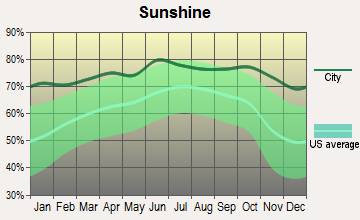
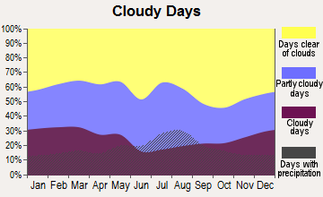
Average climate in North Harding, New Mexico
Based on data reported by over 4,000 weather stations
Earthquake activity:
North Harding-area historical earthquake activity is significantly above New Mexico state average. It is 620% greater than the overall U.S. average.On 8/23/2011 at 05:46:18, a magnitude 5.3 (5.3 MW, Depth: 2.5 mi, Class: Moderate, Intensity: VI - VII) earthquake occurred 81.7 miles away from North Harding center
On 8/10/2005 at 22:08:22, a magnitude 5.0 (5.0 MB, 4.7 MS, 5.0 MW) earthquake occurred 75.0 miles away from North Harding center
On 8/10/2005 at 22:08:22, a magnitude 5.0 (5.0 MW, Depth: 3.1 mi) earthquake occurred 78.6 miles away from the city center
On 8/22/2011 at 23:30:19, a magnitude 4.7 (4.7 MW, Depth: 3.1 mi, Class: Light, Intensity: IV - V) earthquake occurred 76.4 miles away from North Harding center
On 9/5/2001 at 10:52:07, a magnitude 4.5 (4.5 MB, Depth: 3.1 mi) earthquake occurred 84.8 miles away from North Harding center
On 9/5/2001 at 10:52:07, a magnitude 4.5 (4.5 LG) earthquake occurred 84.8 miles away from North Harding center
Magnitude types: regional Lg-wave magnitude (LG), body-wave magnitude (MB), surface-wave magnitude (MS), moment magnitude (MW)
Natural disasters:
The number of natural disasters in Harding County (7) is smaller than the US average (15).Major Disasters (Presidential) Declared: 3
Emergencies Declared: 3
Causes of natural disasters: Floods: 3, Storms: 3, Drought: 1, Fire: 1, Hurricane: 1, Mudslide: 1, Snow: 1, Other: 1 (Note: some incidents may be assigned to more than one category).
Colleges/universities with over 2000 students nearest to North Harding:
- New Mexico Highlands University (about 73 miles; Las Vegas, NM; Full-time enrollment: 2,931)
- Santa Fe Community College (about 115 miles; Santa Fe, NM; FT enrollment: 3,047)
- Eastern New Mexico University-Main Campus (about 133 miles; Portales, NM; FT enrollment: 4,263)
- Amarillo College (about 136 miles; Amarillo, TX; FT enrollment: 6,622)
- West Texas A & M University (about 139 miles; Canyon, TX; FT enrollment: 6,820)
- Adams State University (about 145 miles; Alamosa, CO; FT enrollment: 2,805)
- University of Phoenix-Albuquerque Campus (about 155 miles; Albuquerque, NM; FT enrollment: 2,335)
Points of interest:
Notable locations in North Harding: Lake Windmill (A), Leatherman Windmill (B), McNeil Windmill (C), Old Sabino Camp (D), Short Windmill (E), Slusher Windmill (F), Spear Windmill (G), Starvation Windmill (H), Steinbaugh Windmill (I), Trap Windmill (J), West Spear Windmill (K), Trujillo Camp (L), Schell (M), Burkes (N), Albert P O (O), Freeman Windmill (P), Yates (Q), Twin Creek Ranch (R), Campbell (S), Padilla (T). Display/hide their locations on the map
Churches in North Harding include: Sacred Heart Church Historic Site (A), Carrizo Church (B). Display/hide their locations on the map
Cemeteries: Calvert Cemetery (1), Johnson Cemetery (2), Mestenito Cemetery (3), Trujillo Cemetery (4), Armenta Plaza Cemetery (5), Saint Joseph Cemetery (6), Mofax Cemetery (7). Display/hide their locations on the map
Lakes and reservoirs: Payton Lake (A), Gunn Lake (B), Island Lake (C), Dorhman Lake (D), Church Lake (E), Rock Lake (F), Chicosa Lake (G), Callahan Lake (H). Display/hide their locations on the map
Streams, rivers, and creeks: Garcia Creek (A), Las Canelas Creek (B), Las Cuevas Creek (C), Pat Le Doux Creek (D), Pedernal Creek (E), Ventanas Creek (F), Sauz Creek (G), Salado Creek (H), Sabino Creek (I). Display/hide their locations on the map
Parks in North Harding include: Goodnight-Loving Trail Historical Marker (1), New Goodnight Trail Historical Marker (2), Mills Canyon Historical Marker (3), Chicosa Lake State Park (4). Display/hide their locations on the map
| This place: | 2.0 people |
| New Mexico: | 2.5 people |
| This place: | 58.7% |
| Whole state: | 65.5% |
| This place: | 6.3% |
| Whole state: | 8.2% |
Likely homosexual households (counted as self-reported same-sex unmarried-partner households)
- Lesbian couples: 0.3% of all households
- Gay men: 0.7% of all households
| This place: | 14.8% |
| Whole state: | 18.4% |
| This place: | 3.6% |
| Whole state: | 7.8% |
For population 15 years and over in North Harding:
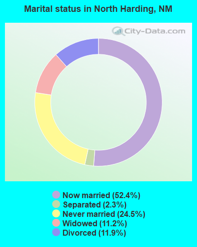
- Never married: 24.5%
- Now married: 52.4%
- Separated: 2.3%
- Widowed: 11.2%
- Divorced: 11.9%
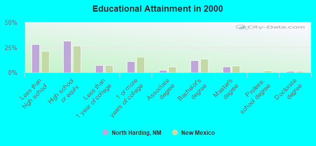
For population 25 years and over in North Harding:
- High school or higher: 71.9%
- Bachelor's degree or higher: 19.3%
- Graduate or professional degree: 7.2%
- Unemployed: 3.5%
- Mean travel time to work (commute): 19.1 minutes
| Here: | 15.3 |
| New Mexico average: | 14.5 |
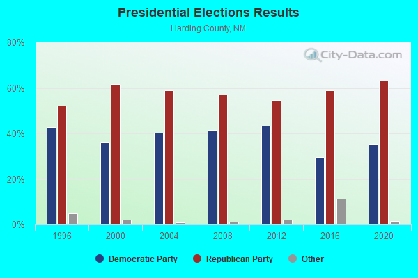
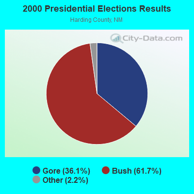
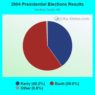
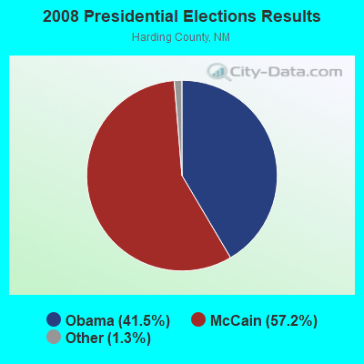
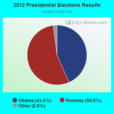
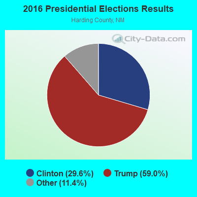
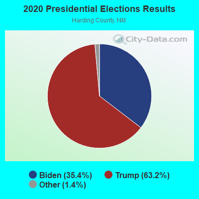
Graphs represent county-level data. Detailed 2008 Election Results
Religion statistics for North Harding, NM (based on Harding County data)
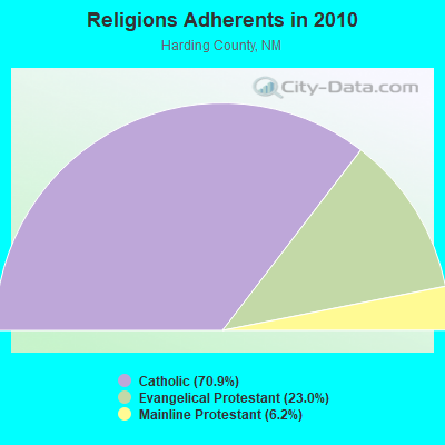
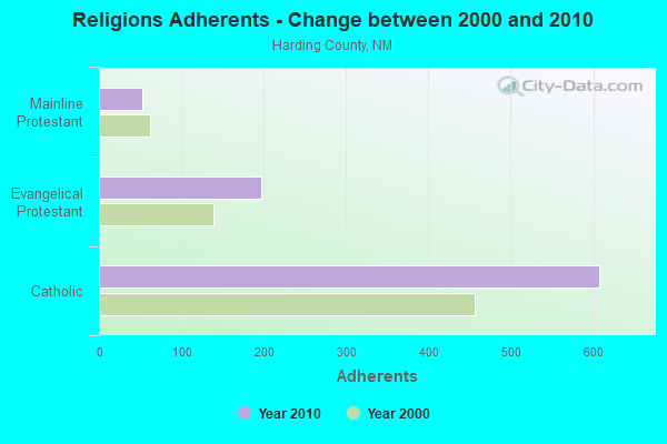
| Religion | Adherents | Congregations |
|---|---|---|
| Catholic | 608 | 3 |
| Evangelical Protestant | 197 | 1 |
| Mainline Protestant | 53 | 2 |
| None | - | - |
Food Environment Statistics:
| Harding County: | 13.97 / 10,000 pop. |
| New Mexico: | 1.44 / 10,000 pop. |
| Harding County: | 27.93 / 10,000 pop. |
| New Mexico: | 7.12 / 10,000 pop. |
| This county: | 7.7% |
| State: | 6.4% |
| This county: | 20.8% |
| State: | 22.1% |
| Harding County: | 13.0% |
| New Mexico: | 11.5% |
Strongest AM radio stations in North Harding:
- KKOB (770 AM; 50 kW; ALBUQUERQUE, NM; Owner: CITADEL BROADCASTING COMPANY)
- KICA (980 AM; 50 kW; CLOVIS, NM; Owner: BROADCAST ENTERTAINMENT CORPORATION)
- KMUL (1380 AM; 50 kW; MULESHOE, TX; Owner: BROADCAST ENTERTAINMENT CORPORATION)
- KGYN (1210 AM; 50 kW; GUYMON, OK; Owner: TELNS BROADCASTING COMPANY, INC.)
- KNMX (540 AM; 5 kW; LAS VEGAS, NM; Owner: SANGRE DE CRISTO B/DCASTING CO, INC)
- KINF (1020 AM; 50 kW; ROSWELL, NM; Owner: JAMES CRYSTAL HOLDINGS OF NEW MEXICO, INC.)
- KOA (850 AM; 50 kW; DENVER, CO; Owner: JACOR BROADCASTING OF COLORADO, INC.)
- KLTT (670 AM; 50 kW; COMMERCE CITY, CO; Owner: KLZ RADIO, INC.)
- KTNN (660 AM; 50 kW; WINDOW ROCK, AZ; Owner: THE NAVAJO NATION)
- KKZN (760 AM; 50 kW; THORNTON, CO; Owner: JACOR BROADCASTING OF COLORADO, INC.)
- KMXA (1090 AM; 50 kW; AURORA, CO; Owner: ENTRAVISION HOLDINGS, LLC)
- KGNC (710 AM; 10 kW; AMARILLO, TX; Owner: MCC RADIO, LLC)
- KHAC (880 AM; 43 kW; TSE BONITO, NM; Owner: WESTERN INDIAN MINISTRIES, INC.)
Strongest FM radio stations in North Harding:
- KRTN-FM (93.9 FM; RATON, NM; Owner: RATON BROADCASTING COMPANY)
TV broadcast stations around North Harding:
- K34FQ (Channel 34; ROY, NM; Owner: REGENTS OF THE UNIVERSITY OF NEW MEXICO)
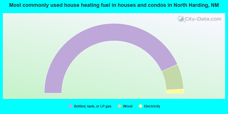
- 86.5%Bottled, tank, or LP gas
- 11.7%Wood
- 1.9%Electricity
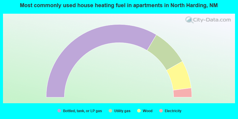
- 67.1%Bottled, tank, or LP gas
- 16.4%Utility gas
- 12.3%Wood
- 4.1%Electricity
North Harding compared to New Mexico state average:
- Median house value significantly below state average.
- Unemployed percentage significantly below state average.
- Black race population percentage significantly below state average.
- Median age significantly above state average.
- Foreign-born population percentage significantly below state average.
- Renting percentage below state average.
- Length of stay since moving in significantly above state average.
- Number of rooms per house significantly below state average.
- House age significantly below state average.
- Number of college students below state average.