North Yarmouth, Maine
Submit your own pictures of this town and show them to the world
- OSM Map
- Google Map
- MSN Map
Population change since 2000: +11.1%
 |
| Males: 1,727 | |
| Females: 1,838 |
| Median resident age: | 42.5 years |
| Maine median age: | 43.0 years |
Zip codes: 04097.
| North Yarmouth: | $123,425 |
| ME: | $69,543 |
Estimated per capita income in 2022: $57,900 (it was $25,180 in 2000)
North Yarmouth town income, earnings, and wages data
Estimated median house or condo value in 2022: $533,282 (it was $156,500 in 2000)
| North Yarmouth: | $533,282 |
| ME: | $290,600 |
Mean prices in 2022: all housing units: $514,200; detached houses: $533,395; townhouses or other attached units: $572,947; in 2-unit structures: $538,406; in 3-to-4-unit structures: $462,507; in 5-or-more-unit structures: $450,834; mobile homes: $93,551
North Yarmouth, ME residents, houses, and apartments details
Detailed information about poverty and poor residents in North Yarmouth, ME
Compare current foreclosures near North Yarmouth, ME:
| Photo | Address | Area | Beds / Baths | Price | Details |
|---|---|---|---|---|---|

|
#1
Hale Rd
Raymond, ME 04071
|
2,808 sq. feet
|
2 baths 3 beds |
$474,900
|
show details |

|
#2
Western Promenade
Auburn, ME 04210
|
2,908 sq. feet
|
3 baths 5 beds |
show details | |

|
#3
Motorcycle Dr
Windham, ME 04062
|
2,772 sq. feet
|
2 baths 3 beds |
show details | |

|
#4
Pleasant St
Lisbon Falls, ME 04252
|
561 sq. feet
|
1 baths 2 beds |
show details | |

|
#5
High St
Windham, ME 04062
|
933 sq. feet
|
1 baths 2 beds |
show details | |

|
#6
Spring St
Lisbon, ME 04250
|
1,141 sq. feet
|
1 baths 3 beds |
show details | |

|
#7
Ring Landing Rd
Casco, ME 04015
|
1,296 sq. feet
|
1 baths 3 beds |
show details | |

|
#8
Saco St Unit 2
Westbrook, ME 04092
|
1,725 sq. feet
|
2 baths 4 beds |
show details | |

|
#9
Pownal Rd
Auburn, ME 04210
|
1,099 sq. feet
|
1 baths 2 beds |
show details | |

|
#10
Minot Ave
Auburn, ME 04210
|
1,444 sq. feet
|
1 baths 3 beds |
show details |
| Photo | Address | Area | Beds / Baths | Price | Details |
|---|---|---|---|---|---|

|
#11
Bridge St
Westbrook, ME 04092
|
1,268 sq. feet
|
1 baths 2 beds |
show details | |

|
#12
Majestic Hts
Windham, ME 04062
|
1,668 sq. feet
|
2 baths 3 beds |
show details | |

|
#13
Anita Ave
Auburn, ME 04210
|
2,016 sq. feet
|
1 baths 3 beds |
show details | |

|
#14
Haskell St
Westbrook, ME 04092
|
1,573 sq. feet
|
1 baths 3 beds |
show details | |

|
#15
Bruce Hill Rd
Cumberland Center, ME 04021
|
2,536 sq. feet
|
2 baths 3 beds |
show details | |

|
#16
Windham Center Rd
Windham, ME 04062
|
1,576 sq. feet
|
1 baths 3 beds |
show details | |

|
#17
Stevens Mill Rd
Auburn, ME 04210
|
1,547 sq. feet
|
2 baths 4 beds |
show details | |

|
#18
Emerson Dr
Windham, ME 04062
|
1,080 sq. feet
|
1 baths 3 beds |
show details | |

|
#19
Coach Rd
South Portland, ME 04106
|
1,300 sq. feet
|
2 baths 3 beds |
show details | |

|
#20
Running Brook Rd
Windham, ME 04062
|
1,749 sq. feet
|
2 baths 3 beds |
show details |
| Photo | Address | Area | Beds / Baths | Price | Details |
|---|---|---|---|---|---|

|
#21
Jennifer Way
Gorham, ME 04038
|
1,414 sq. feet
|
1 baths 3 beds |
show details | |

|
#22
Goldie Ln
Standish, ME 04084
|
2,273 sq. feet
|
1 baths 3 beds |
show details | |

|
#23
Cottage Rd
Windham, ME 04062
|
1,404 sq. feet
|
1 baths 2 beds |
show details | |

|
#24
Church St
Westbrook, ME 04092
|
1,529 sq. feet
|
1 baths 3 beds |
show details | |

|
#25
Congress St Unit 307
Portland, ME 04101
|
- sq. feet
|
- baths - beds |
show details | |

|
#26
Gray Rd
Cumberland Center, ME 04021
|
- sq. feet
|
- baths - beds |
show details | |

|
#27
Sabattus Creek Dr
Lisbon, ME 04250
|
- sq. feet
|
- baths - beds |
show details | |

|
#28
Bickford Ave
Brunswick, ME 04011
|
- sq. feet
|
- baths - beds |
show details | |

|
#29
Yarmouth Rd
Gray, ME 04039
|
- sq. feet
|
- baths - beds |
show details | |

|
#30
N Kelsey St Apt 2
South Portland, ME 04106
|
- sq. feet
|
- baths - beds |
show details |
| Photo | Address | Area | Beds / Baths | Price | Details |
|---|---|---|---|---|---|

|
#31
Main St Apt 15
South Portland, ME 04106
|
- sq. feet
|
- baths - beds |
show details | |

|
#32
Devereaux Cir
South Portland, ME 04106
|
- sq. feet
|
- baths - beds |
show details | |

|
#33
Park Ave Apt 2
Portland, ME 04101
|
- sq. feet
|
- baths - beds |
show details | |

|
#34
Townhouse Dr
South Portland, ME 04106
|
- sq. feet
|
- baths - beds |
show details | |

|
#35
Wainwright Cir W
South Portland, ME 04106
|
- sq. feet
|
- baths - beds |
show details | |

|
#36
Cape Woods Dr
Cape Elizabeth, ME 04107
|
- sq. feet
|
- baths - beds |
show details | |

|
#37
Riverside Dr # 650
Auburn, ME 04210
|
- sq. feet
|
- baths - beds |
show details | |

|
#38
Belmont Ct, Unit 8
Auburn, ME 04210
|
- sq. feet
|
- baths - beds |
show details | |

|
#39
Bartlett St
Lewiston, ME 04240
|
- sq. feet
|
- baths - beds |
show details | |

|
#40
Congress St # 2
Portland, ME 04102
|
- sq. feet
|
- baths - beds |
show details |
| Photo | Address | Area | Beds / Baths | Price | Details |
|---|---|---|---|---|---|

|
#41
Sargent St
Westbrook, ME 04092
|
- sq. feet
|
- baths - beds |
show details | |

|
#42
Liberty Way
Portland, ME 04103
|
- sq. feet
|
- baths - beds |
show details | |

|
#43
Pleasant Ave
Portland, ME 04103
|
- sq. feet
|
- baths - beds |
show details | |

|
#44
Ocean Ave
Portland, ME 04103
|
- sq. feet
|
- baths - beds |
show details | |

|
#45
Lambert St # C2
Portland, ME 04103
|
- sq. feet
|
- baths - beds |
show details | |

|
#46
Cumberland Ave # 302
Portland, ME 04101
|
- sq. feet
|
- baths - beds |
show details | |

|
#47
Ocean Ave
Portland, ME 04103
|
- sq. feet
|
- baths - beds |
show details | |

|
#48
Durham Rd
Freeport, ME 04032
|
- sq. feet
|
- baths - beds |
show details | |

|
#49
Liza Harmon Dr Apt 128
Westbrook, ME 04092
|
- sq. feet
|
- baths - beds |
show details | |

|
Check over 1 million property listings on Foreclosure.com!
|
browse all offers | |||

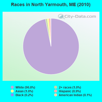
- 3,45196.8%White alone
- 341.0%Asian alone
- 351.0%Two or more races
- 320.9%Hispanic
- 80.2%Black alone
- 40.1%American Indian alone
- 10.03%Native Hawaiian and Other
Pacific Islander alone
Races in North Yarmouth detailed stats: ancestries, foreign born residents, place of birth
According to our research of Maine and other state lists, there were 5 registered sex offenders living in North Yarmouth, Maine as of April 25, 2024.
The ratio of all residents to sex offenders in North Yarmouth is 713 to 1.
The ratio of registered sex offenders to all residents in this city is lower than the state average.
 Recent articles from our blog. Our writers, many of them Ph.D. graduates or candidates, create easy-to-read articles on a wide variety of topics.

North Yarmouth, ME City Guides:
Ancestries: Irish (24.2%), English (24.0%), French (9.2%), United States (8.4%), German (8.4%), French Canadian (7.5%).
Current Local Time: EST time zone
Incorporated on 06/17/1683
Land area: 21.1 square miles.
Population density: 169 people per square mile (very low).
173 residents are foreign born (2.0% North America, 1.7% Asia, 1.3% Europe).
| This town: | 5.4% |
| Maine: | 2.9% |
| North Yarmouth town: | 1.5% ($2,275) |
| Maine: | 1.5% ($1,417) |
Nearest city with pop. 50,000+: Portland, ME  (13.4 miles , pop. 64,249).
Nearest city with pop. 200,000+: Boston, MA (114.6 miles , pop. 589,141).
Nearest city with pop. 1,000,000+: Bronx, NY (279.0 miles , pop. 1,332,650).
Nearest cities:
), ), ), ), )Latitude: 43.86 N, Longitude: 70.24 W
Area code commonly used in this area: 207
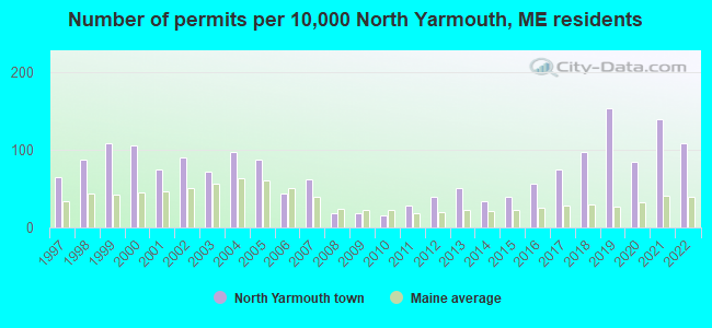
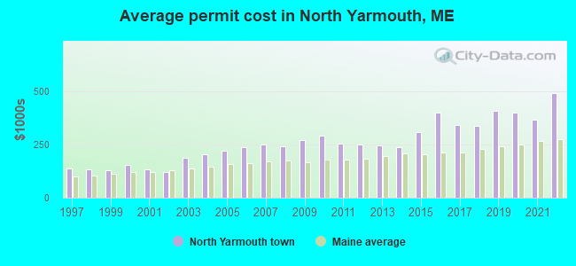
Single-family new house construction building permits:
- 2022: 35 buildings, average cost: $492,900
- 2021: 45 buildings, average cost: $366,300
- 2020: 27 buildings, average cost: $400,000
- 2019: 49 buildings, average cost: $408,200
- 2018: 31 buildings, average cost: $337,100
- 2017: 24 buildings, average cost: $340,000
- 2016: 18 buildings, average cost: $400,000
- 2015: 13 buildings, average cost: $307,700
- 2014: 11 buildings, average cost: $238,100
- 2013: 16 buildings, average cost: $248,100
- 2012: 13 buildings, average cost: $250,700
- 2011: 9 buildings, average cost: $252,600
- 2010: 5 buildings, average cost: $293,000
- 2009: 6 buildings, average cost: $271,000
- 2008: 6 buildings, average cost: $242,500
- 2007: 20 buildings, average cost: $248,700
- 2006: 14 buildings, average cost: $238,600
- 2005: 28 buildings, average cost: $221,000
- 2004: 31 buildings, average cost: $204,900
- 2003: 23 buildings, average cost: $187,200
- 2002: 29 buildings, average cost: $119,200
- 2001: 24 buildings, average cost: $133,800
- 2000: 34 buildings, average cost: $155,100
- 1999: 35 buildings, average cost: $128,800
- 1998: 28 buildings, average cost: $131,900
- 1997: 21 buildings, average cost: $137,300
| Here: | 2.0% |
| Maine: | 3.4% |
- Health care (11.8%)
- Professional, scientific, technical services (9.5%)
- Construction (9.4%)
- Finance & insurance (9.0%)
- Educational services (7.3%)
- Used merchandise, gift, novelty, souvenir, other miscellaneous stores (4.8%)
- Accommodation & food services (4.7%)
- Construction (14.4%)
- Professional, scientific, technical services (12.3%)
- Finance & insurance (5.7%)
- Health care (5.5%)
- Public administration (4.3%)
- Used merchandise, gift, novelty, souvenir, other miscellaneous stores (4.1%)
- Accommodation & food services (4.0%)
- Health care (18.5%)
- Finance & insurance (12.6%)
- Educational services (11.4%)
- Professional, scientific, technical services (6.5%)
- Used merchandise, gift, novelty, souvenir, other miscellaneous stores (5.6%)
- Accommodation & food services (5.5%)
- Construction (4.0%)

- Other sales and related occupations, including supervisors (5.6%)
- Other management occupations, except farmers and farm managers (4.3%)
- Registered nurses (3.8%)
- Other office and administrative support workers, including supervisors (3.5%)
- Secretaries and administrative assistants (3.3%)
- Computer specialists (3.1%)
- Retail sales workers, except cashiers (3.0%)
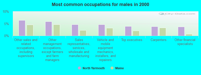
- Other sales and related occupations, including supervisors (6.4%)
- Other management occupations, except farmers and farm managers (5.8%)
- Sales representatives, services, wholesale and manufacturing (4.6%)
- Vehicle and mobile equipment mechanics, installers, and repairers (4.6%)
- Top executives (3.9%)
- Carpenters (3.8%)
- Other financial specialists (3.7%)

- Registered nurses (6.9%)
- Secretaries and administrative assistants (6.8%)
- Other office and administrative support workers, including supervisors (6.6%)
- Other sales and related occupations, including supervisors (4.7%)
- Retail sales workers, except cashiers (4.7%)
- Bookkeeping, accounting, and auditing clerks (4.7%)
- Information and record clerks, except customer service representatives (4.6%)
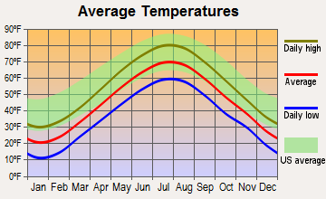
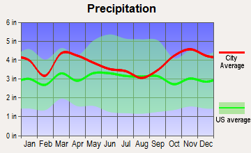
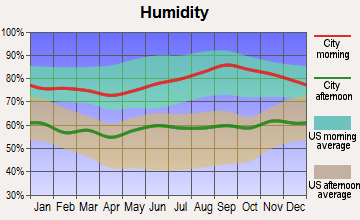
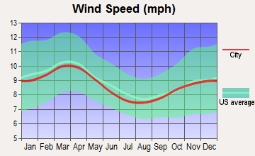
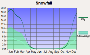
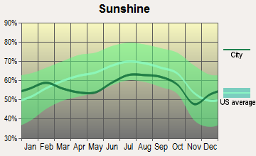
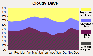
Average climate in North Yarmouth, Maine
Based on data reported by over 4,000 weather stations
(lower is better)
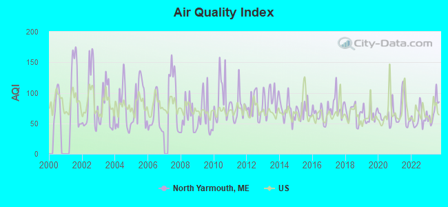
Air Quality Index (AQI) level in 2023 was 70.7. This is about average.
| City: | 70.7 |
| U.S.: | 72.6 |
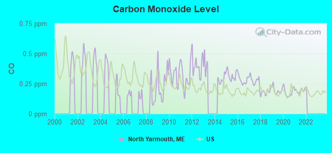
Carbon Monoxide (CO) [ppm] level in 2021 was 0.192. This is better than average. Closest monitor was 13.7 miles away from the city center.
| City: | 0.192 |
| U.S.: | 0.251 |
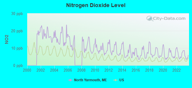
Nitrogen Dioxide (NO2) [ppb] level in 2023 was 5.47. This is about average. Closest monitor was 13.6 miles away from the city center.
| City: | 5.47 |
| U.S.: | 5.11 |
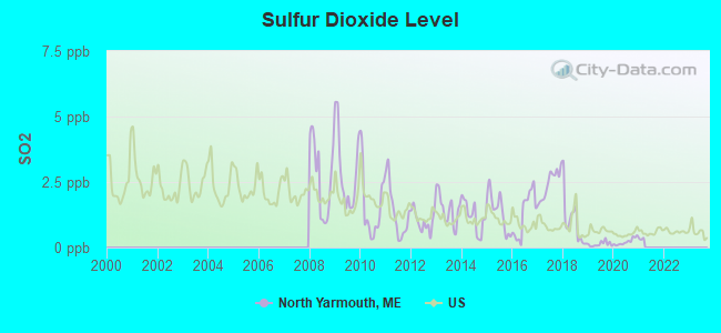
Sulfur Dioxide (SO2) [ppb] level in 2020 was 0.222. This is significantly better than average. Closest monitor was 4.9 miles away from the city center.
| City: | 0.222 |
| U.S.: | 1.515 |
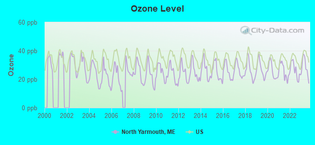
Ozone [ppb] level in 2023 was 28.6. This is about average. Closest monitor was 3.6 miles away from the city center.
| City: | 28.6 |
| U.S.: | 33.3 |
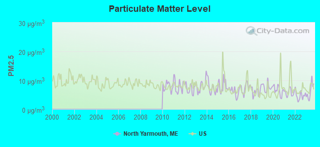
Particulate Matter (PM2.5) [µg/m3] level in 2023 was 6.27. This is better than average. Closest monitor was 12.5 miles away from the city center.
| City: | 6.27 |
| U.S.: | 8.11 |
Tornado activity:
North Yarmouth-area historical tornado activity is above Maine state average. It is 80% smaller than the overall U.S. average.
On 7/8/1996, a category F2 (max. wind speeds 113-157 mph) tornado 26.6 miles away from the North Yarmouth town center caused $10,000 in damages.
On 7/31/1971, a category F2 tornado 35.6 miles away from the town center caused between $50,000 and $500,000 in damages.
Earthquake activity:
North Yarmouth-area historical earthquake activity is significantly above Maine state average. It is 75% smaller than the overall U.S. average.On 10/16/2012 at 23:12:25, a magnitude 4.7 (4.7 ML, Depth: 10.0 mi, Class: Light, Intensity: IV - V) earthquake occurred 27.5 miles away from North Yarmouth center
On 4/20/2002 at 10:50:47, a magnitude 5.3 (5.3 ML, Depth: 3.0 mi, Class: Moderate, Intensity: VI - VII) earthquake occurred 177.3 miles away from North Yarmouth center
On 1/19/1982 at 00:14:42, a magnitude 4.7 (4.5 MB, 4.7 MD, 4.5 LG) earthquake occurred 72.4 miles away from the city center
On 4/20/2002 at 10:50:47, a magnitude 5.2 (5.2 MB, 4.2 MS, 5.2 MW, 5.0 MW) earthquake occurred 177.9 miles away from North Yarmouth center
On 10/7/1983 at 10:18:46, a magnitude 5.3 (5.1 MB, 5.3 LG, 5.1 ML) earthquake occurred 204.5 miles away from the city center
On 2/26/1999 at 03:38:43, a magnitude 3.8 (3.8 LG, Depth: 2.0 mi, Class: Light, Intensity: II - III) earthquake occurred 55.9 miles away from North Yarmouth center
Magnitude types: regional Lg-wave magnitude (LG), body-wave magnitude (MB), duration magnitude (MD), local magnitude (ML), surface-wave magnitude (MS), moment magnitude (MW)
Natural disasters:
The number of natural disasters in Cumberland County (33) is a lot greater than the US average (15).Major Disasters (Presidential) Declared: 22
Emergencies Declared: 10
Causes of natural disasters: Floods: 19, Storms: 13, Snows: 7, Winter Storms: 6, Heavy Rains: 3, Hurricanes: 3, Winds: 3, Blizzard: 1, Ice Storm: 1, Mudslide: 1, Snowfall: 1, Snowstorm: 1, Tornado: 1, Other: 2 (Note: some incidents may be assigned to more than one category).
Hospitals and medical centers near North Yarmouth:
- BRENTWOOD REHAB AND NURSING CENTER (Nursing Home, about 6 miles away; YARMOUTH, ME)
- FREEPORT NURSING AND REHAB CENTER (Nursing Home, about 8 miles away; FREEPORT, ME)
- SEDGEWOOD COMMONS (Nursing Home, about 9 miles away; FALMOUTH, ME)
- FALMOUTH BY THE SEA (Nursing Home, about 10 miles away; FALMOUTH, ME)
- ST JOSEPH'S REHABILITATION AND RESIDENCE (Nursing Home, about 12 miles away; PORTLAND, ME)
- CHS - HOSPICE (Hospital, about 12 miles away; PORTLAND, ME)
- SEASIDE REHAB AND HEALTH CARE (Nursing Home, about 13 miles away; PORTLAND, ME)
Airports located in North Yarmouth:
- Eagle Field Airport (15ME) (Runways: 1)
Colleges/universities with over 2000 students nearest to North Yarmouth:
- Saint Joseph's College of Maine (about 13 miles; Standish, ME; Full-time enrollment: 2,010)
- University of Southern Maine (about 14 miles; Portland, ME; FT enrollment: 6,647)
- Southern Maine Community College (about 15 miles; South Portland, ME; FT enrollment: 4,666)
- University of New England (about 29 miles; Biddeford, ME; FT enrollment: 4,539)
- University of Maine at Augusta (about 40 miles; Augusta, ME; FT enrollment: 3,204)
- University of Maine at Farmington (about 57 miles; Farmington, ME; FT enrollment: 2,036)
- University of New Hampshire-Main Campus (about 61 miles; Durham, NH; FT enrollment: 15,243)
Points of interest:
Notable location: North Yarmouth Fire / Rescue (A). Display/hide its location on the map
Church in North Yarmouth: First Congregational Church (A). Display/hide its location on the map
Cemetery: Pine Grove Cemetery (1). Display/hide its location on the map
Reservoir: Yarmouth Reservoir (A). Display/hide its location on the map
Streams, rivers, and creeks: Toddy Brook (A), Deer Brook (B), Chandler Brook (C). Display/hide their locations on the map
Birthplace of: Rufus Anderson - Christian missionary, William Todd (1803–1873) - Businessman.
Drinking water stations with addresses in North Yarmouth and their reported violations in the past:
TODDY BROOK GOLF COURSE (Population served: 100, Groundwater):Past monitoring violations:
- 7 routine major monitoring violations
- 2 regular monitoring violations
| This town: | 2.7 people |
| Maine: | 2.3 people |
| This town: | 79.9% |
| Whole state: | 62.9% |
| This town: | 6.4% |
| Whole state: | 9.4% |
Likely homosexual households (counted as self-reported same-sex unmarried-partner households)
- Lesbian couples: 0.7% of all households
- Gay men: 0.4% of all households
| This town: | 2.3% |
| Whole state: | 10.9% |
| This town: | 1.3% |
| Whole state: | 4.1% |
For population 15 years and over in North Yarmouth:
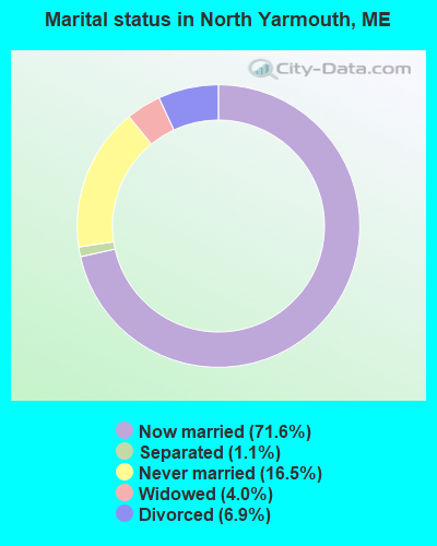
- Never married: 16.5%
- Now married: 71.6%
- Separated: 1.1%
- Widowed: 4.0%
- Divorced: 6.9%
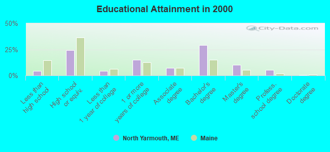
For population 25 years and over in North Yarmouth:
- High school or higher: 95.5%
- Bachelor's degree or higher: 44.7%
- Graduate or professional degree: 15.8%
- Unemployed: 3.7%
- Mean travel time to work (commute): 28.2 minutes
| Here: | 9.8 |
| Maine average: | 11.2 |
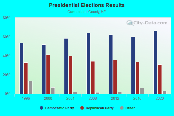
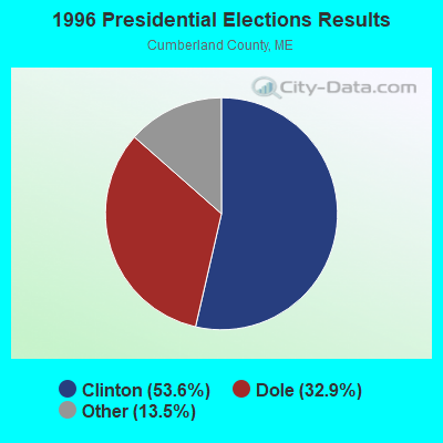
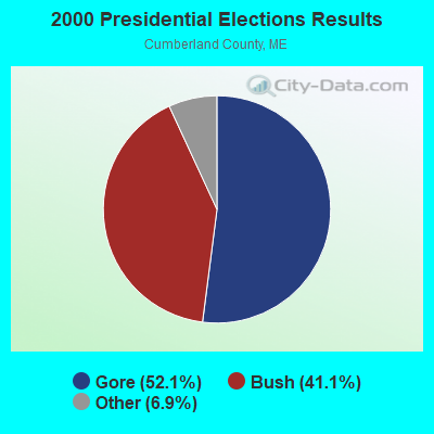
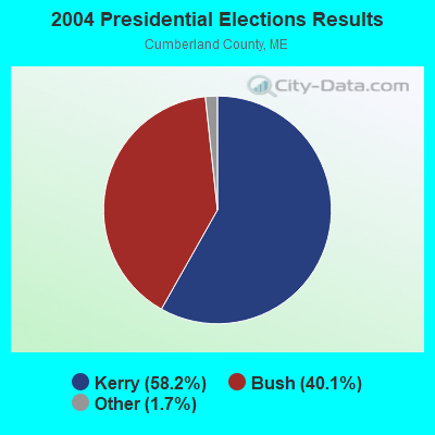
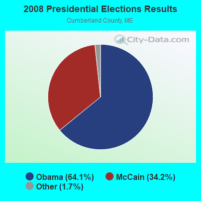
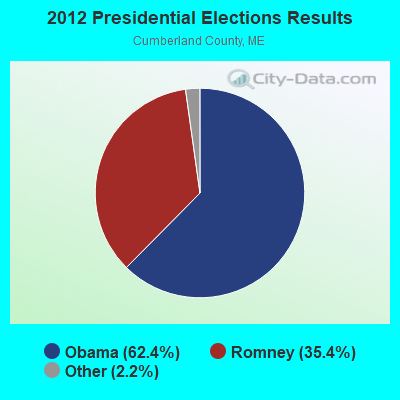
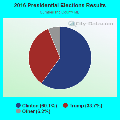
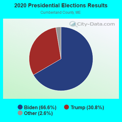
Graphs represent county-level data. Detailed 2008 Election Results
Political contributions by individuals in North Yarmouth, ME
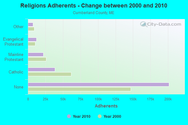
Religion statistics for North Yarmouth, ME (based on Cumberland County data)
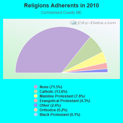
| Religion | Adherents | Congregations |
|---|---|---|
| Catholic | 38,243 | 19 |
| Mainline Protestant | 22,030 | 96 |
| Evangelical Protestant | 12,007 | 85 |
| Other | 7,187 | 44 |
| Orthodox | 500 | 1 |
| Black Protestant | 285 | 2 |
| None | 201,422 | - |
Food Environment Statistics:
| Cumberland County: | 2.62 / 10,000 pop. |
| State: | 2.80 / 10,000 pop. |
| Cumberland County: | 0.11 / 10,000 pop. |
| Maine: | 0.14 / 10,000 pop. |
| Cumberland County: | 2.44 / 10,000 pop. |
| Maine: | 2.20 / 10,000 pop. |
| Cumberland County: | 3.82 / 10,000 pop. |
| State: | 5.75 / 10,000 pop. |
| Here: | 12.01 / 10,000 pop. |
| State: | 11.02 / 10,000 pop. |
| Cumberland County: | 7.1% |
| Maine: | 8.2% |
| This county: | 19.5% |
| Maine: | 25.0% |
Strongest AM radio stations in North Yarmouth:
- WGAN (560 AM; 5 kW; PORTLAND, ME; Owner: SAGA COMMUNICATIONS OF NEW ENGLAND, LLC)
- WMTW (870 AM; 10 kW; GORHAM, ME; Owner: RADIO PARTNERS OF MAINE, L.P.)
- WLOB (1310 AM; 5 kW; PORTLAND, ME; Owner: ATLANTIC COAST RADIO, LLC)
- WJAE (1440 AM; 5 kW; WESTBROOK, ME; Owner: ALTANTIC COAST RADIO, LLC)
- WLAM (1470 AM; 5 kW; LEWISTON, ME; Owner: RADIO PARTNERS OF MAINE, L.P.)
- WZAN (970 AM; 5 kW; PORTLAND, ME; Owner: SAGA COMMUNICATIONS OF NEW ENGLAND, LLC)
- WJJB (900 AM; 1 kW; BRUNSWICK, ME; Owner: ATLANTIC COAST RADIO, LLC)
- WRKO (680 AM; 50 kW; BOSTON, MA; Owner: ENTERCOM BOSTON LICENSE, LLC)
- WTME (780 AM; 10 kW; RUMFORD, ME; Owner: MOUNTAIN VALLEY BROADCASTING, INC.)
- WEEI (850 AM; 50 kW; BOSTON, MA; Owner: ENTERCOM BOSTON LICENSE, LLC)
- WGIN (930 AM; 10 kW; ROCHESTER, NH; Owner: CAPSTAR TX LIMITED PARTNERSHIP)
- WBAE (1490 AM; 1 kW; PORTLAND, ME; Owner: SAGA COMMUNICATIONS OF NEW ENGLAND, LLC)
- WBZ (1030 AM; 50 kW; BOSTON, MA; Owner: INFINITY BROADCASTING OPERATIONS, INC.)
Strongest FM radio stations in North Yarmouth:
- WJBQ (97.9 FM; PORTLAND, ME; Owner: CITADEL BROADCASTING COMPANY)
- WMTW-FM (106.7 FM; NORTH WINDHAM, ME; Owner: RADIO PARTNERS OF MAINE, L.P.)
- WTHT (107.5 FM; LEWISTON, ME; Owner: RADIO PARTNERS OF MAINE, L.P.)
- WMEK-FM (99.9 FM; AUBURN, ME; Owner: RADIO PARTNERS OF MAINE, L.P.)
- WBLM (102.9 FM; PORTLAND, ME; Owner: CITADEL BROADCASTING COMPANY)
- WPOR (101.9 FM; PORTLAND, ME; Owner: SAGA COMMUNICATIONS OF NEW ENGLAND, LLC)
- WMSJ (89.3 FM; FREEPORT, ME; Owner: DOWNEAST CHRISTIAN COMMUNICATIONS)
- WMEA (90.1 FM; PORTLAND, ME; Owner: MAINE PUBLIC BROADCASTING CORPORATION)
- WJJB-FM (95.5 FM; TOPSHAM, ME; Owner: ATLANTIC COAST RADIO, LLC)
- WMGX (93.1 FM; PORTLAND, ME; Owner: SAGA COMMUNICATIONS OF NEW ENGLAND, LLC)
- WPKQ (103.7 FM; NORTH CONWAY, NH; Owner: CITADEL BROADCASTING COMPANY)
- WHOM (94.9 FM; MT. WASHINGTON, NH; Owner: CITADEL BROADCASTING COMPANY)
- WCLZ (98.9 FM; BRUNSWICK, ME; Owner: CITADEL BROADCASTING COMPANY)
- WYNZ (100.9 FM; WESTBROOK, ME; Owner: SAGA COMMUNICATIONS OF NEW ENGLAND, LLC)
- WSCY (106.9 FM; MOULTONBOROUGH, NH; Owner: NORTHEAST COMMUNICATIONS CORPORATION)
- WCYI (93.9 FM; LEWISTON, ME; Owner: CITADEL BROADCASTING COMPANY)
- WYFP (91.9 FM; HARPSWELL, ME; Owner: BIBLE BROADCASTING NETWORK, INC.)
- WBCI (105.9 FM; BATH, ME; Owner: BLOUNT COMMUNICATIONS, INC.)
- WLOB-FM (96.3 FM; RUMFORD, ME; Owner: ATLANTIC COAST RADIO, LLC)
- WCYY (94.3 FM; BIDDEFORD, ME; Owner: CITADEL BROADCASTING COMPANY)
TV broadcast stations around North Yarmouth:
- WPXT (Channel 51; PORTLAND, ME; Owner: HMW, INC.)
- WPME (Channel 35; LEWISTON, ME; Owner: KB PRIME MEDIA LLC)
- W32CA (Channel 32; PORTLAND, ME; Owner: NATIONAL MINORITY T.V., INC.)
- WGME-TV (Channel 13; PORTLAND, ME; Owner: WGME LICENSEE, LLC)
- WMTW-TV (Channel 8; POLAND SPRING, ME; Owner: WMTW BROADCAST GROUP, LLC)
- WCSH (Channel 6; PORTLAND, ME; Owner: PACIFIC AND SOUTHERN COMPANY, INC.)
- W58CM (Channel 58; BANGOR, ME; Owner: MS COMMUNICATIONS, LLC)
- W57AP (Channel 57; FALMOUTH, ME; Owner: SHERWOOD H. CRAIG)
- WMEA-TV (Channel 26; BIDDEFORD, ME; Owner: MAINE PUBLIC BROADCASTING CORP.)
- WPFO (Channel 23; WATERVILLE, ME; Owner: CMCG PORTLAND LICENSE LLC)
- WCBB (Channel 10; AUGUSTA, ME; Owner: MAINE PUBLIC BROADCASTING CORP.)
- WLLB-LP (Channel 15; PORTLAND, ME; Owner: CARTER BROADCASTING CORPORATION)
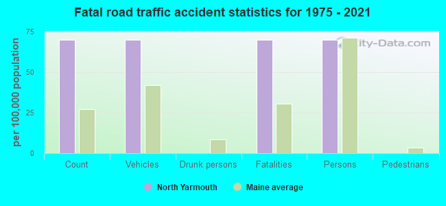
North Yarmouth fatal accident list:
Jan 4, 1997 09:30 AM, 9, Vehicles: 1, Persons: 1, Fatalities: 1
- National Bridge Inventory (NBI) Statistics
- 5Number of bridges
- 33ft / 10.4mTotal length
- 6,880Total average daily traffic
- 343Total average daily truck traffic
- 10,089Total future (year 2036) average daily traffic
FCC Registered Antenna Towers:
5- Peter M Connolly, 40 Parsonage Road (Lat: 43.835472 Lon: -70.250639), Type: 48.1, Overall height: 45.7 m, Registrant: Holland & Knight L.L.P., Pconnolly@hklaw.Com, , Washi-ngton, Phone: (202) 862-5989
- Peter M Connolly, 40 Parsonage Road (Lat: 43.835472 Lon: -70.250639), Type: 48.1, Overall height: 45.7 m, Registrant: Holland & Knight L.L.P., Pconnolly@hklaw.Com, , Washi-ngton, Phone: (202) 862-5989
- Cayla Gamble, 40 Parsonage Road (Lat: 43.835472 Lon: -70.250639), Type: 48.1, Structure height: 23005 m, Overall height: 45.7 m, Registrant: Wilkinson Barker Knauer, LLP, Gwerner@wbklaw.Com, , Washi-ngton, Phone: (202) 383-3420
- Cayla Gamble, 40 Public Works Way (Lat: 43.835472 Lon: -70.250667), Type: 48.2, Structure height: 23005 m, Overall height: 45.7 m, Registrant: Wilkinson Barker Knauer, LLP, Gwerner@wbklaw.Com, , Washi-ngton, Phone: (202) 383-3420
- Cayla Gamble, 40 Public Works Way (Lat: 43.835472 Lon: -70.250667), Type: 48.2, Structure height: 23005 m, Overall height: 45.7 m, Registrant: Wilkinson Barker Knauer, LLP, Gwerner@wbklaw.Com, , Washi-ngton, Phone: (202) 383-3420
FCC Registered Broadcast Land Mobile Towers:
2- Well Panel 3 (Lat: 43.252583 Lon: -70.240889), Call Sign: WNKW542,
Assigned Frequencies: 173.262 MHz, Grant Date: 11/16/2011, Expiration Date: 02/03/2022, Cancellation Date: 04/09/2022, Registrant: Tcs Communications Corp, Salisbury, MA 01952, Phone: (978) 465-7932, Fax: (978) 462-8980, Email:
- Standpipe Rtu (Lat: 43.837583 Lon: -70.260611), Structure height: 3 m, Call Sign: WNKW543,
Assigned Frequencies: 173.262 MHz, Grant Date: 11/09/2023, Expiration Date: 11/16/2033, Registrant: Tcs Communications Corp, Salisbury, MA 01952, Phone: (978) 465-7932, Fax: (978) 462-8980, Email:
FCC Registered Microwave Towers:
1- NORTH YARMOUTH, 40 Parsonage Road (Lat: 43.835472 Lon: -70.250639), Type: Mtower, Structure height: 45.7 m, Overall height: 48.2 m, Call Sign: WQRN925,
Assigned Frequencies: 11305.0 MHz, Grant Date: 05/23/2023, Expiration Date: 06/27/2033, Certifier: John E Monday, Registrant: At&t Services, Inc., 208 S Akard St, 20f, Dallas, TX 75202, Phone: (855) 699-7073, Email:
FCC Registered Amateur Radio Licenses:
25 (See the full list of FCC Registered Amateur Radio Licenses in North Yarmouth)FAA Registered Aircraft:
3- Aircraft: AERONCA 7AC (Category: Land, Seats: 2, Weight: Up to 12,499 Pounds, Speed: 90 mph), Engine: CONT MOTOR A&C65 SERIES (65 HP) (Reciprocating)
N-Number: 1427E, N1427E, N-1427E, Serial Number: 7AC-4990, Year manufactured: 1946, Airworthiness Date: 04/21/1956, Certificate Issue Date: 10/15/1984
Registrant (Individual): John W Sowles, 2 Walnut Rd, North Yarmouth, ME 04097 - Aircraft: AERO COMMANDER 500 S (Category: Land, Engines: 2, Seats: 7, Weight: Up to 12,499 Pounds, Speed: 172 mph), Engine: LYCOMING TI0-540 SER (310 HP) (Reciprocating)
N-Number: 1938S, N1938S, N-1938S, Serial Number: 3167, Year manufactured: 1973, Airworthiness Date: 10/17/1973, Certificate Issue Date: 11/21/2019
Registrant (LLC): Cavu Aviation LLC, 170 Delwin Dr, North Yarmouth, ME 04097 - Aircraft: CESSNA 170B (Category: Land, Seats: 4, Weight: Up to 12,499 Pounds, Speed: 105 mph), Engine: CONT MOTOR 0-300 SER (145 HP) (Reciprocating)
N-Number: 3487D, N3487D, N-3487D, Serial Number: 27030, Year manufactured: 1955, Certificate Issue Date: 08/02/2010
Registrant (Individual): John W Sowles, 2 Walnut Hill Rd, North Yarmouth, ME 04097
2003 - 2018 National Fire Incident Reporting System (NFIRS) incidents
- Fire incident types reported to NFIRS in North Yarmouth, ME
- 8557.0%Structure Fires
- 4530.2%Outside Fires
- 1510.1%Mobile Property/Vehicle Fires
- 42.7%Other
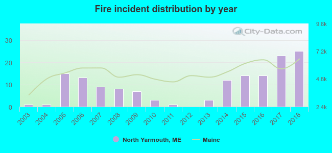 According to the data from the years 2003 - 2018 the average number of fire incidents per year is 9. The highest number of reported fires - 25 took place in 2018, and the least - 0 in 2012. The data has a rising trend.
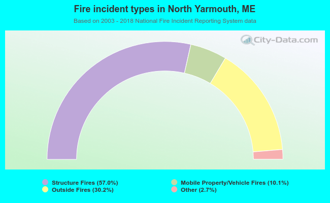 When looking into fire subcategories, the most reports belonged to: Structure Fires (57.0%), and Outside Fires (30.2%).
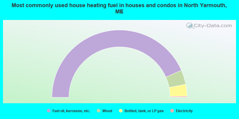
- 86.9%Fuel oil, kerosene, etc.
- 6.9%Wood
- 5.7%Bottled, tank, or LP gas
- 0.5%Electricity
- 80.0%Fuel oil, kerosene, etc.
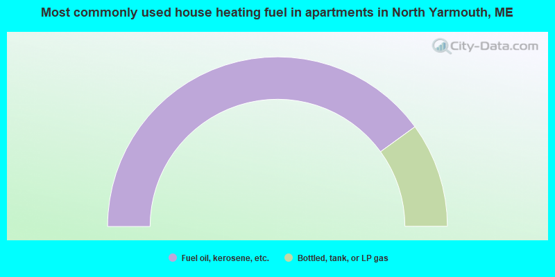
- 20.0%Bottled, tank, or LP gas
North Yarmouth compared to Maine state average:
- Median household income above state average.
- Median house value above state average.
- Unemployed percentage significantly below state average.
- Black race population percentage significantly below state average.
- Hispanic race population percentage below state average.
- Renting percentage significantly below state average.
- Length of stay since moving in significantly above state average.
- Number of rooms per house significantly below state average.
- House age significantly below state average.
- Percentage of population with a bachelor's degree or higher above state average.

|
|
Total of 19 patent applications in 2008-2024.