Ogden Valley, Utah
Submit your own pictures of this place and show them to the world
- OSM Map
- General Map
- Google Map
- MSN Map

| Males: 3,438 | |
| Females: 3,142 |
| Median resident age: | 35.3 years |
| Utah median age: | 27.1 years |
Zip code: 84310
| Ogden Valley: | $118,866 |
| UT: | $89,168 |
Estimated per capita income in 2022: $44,981 (it was $22,324 in 2000)
Ogden Valley CCD income, earnings, and wages data
Estimated median house or condo value in 2022: $795,923 (it was $223,500 in 2000)
| Ogden Valley: | $795,923 |
| UT: | $499,500 |
Mean prices in 2022: all housing units: $489,906; detached houses: $518,555; townhouses or other attached units: $367,378; in 2-unit structures: $372,281; in 3-to-4-unit structures: $252,139; in 5-or-more-unit structures: $197,854; mobile homes: $72,035
Detailed information about poverty and poor residents in Ogden Valley, UT
Compare current foreclosures near Ogden Valley, UT:
| Photo | Address | Area | Beds / Baths | Price | Details |
|---|---|---|---|---|---|

|
#1
Grant Ave
Ogden, UT 84404
|
1,025 sq. feet
|
1 baths 4 beds |
show details | |

|
#2
Lakeview Dr
Ogden, UT 84414
|
1,595 sq. feet
|
3 baths 6 beds |
show details | |

|
#3
E Canyon Dr
Ogden, UT 84405
|
1,595 sq. feet
|
2 baths 2 beds |
show details | |

|
#4
Foothill Dr
Ogden, UT 84403
|
3,219 sq. feet
|
3 baths 4 beds |
show details | |

|
#5
16th St
Ogden, UT 84404
|
- sq. feet
|
1 baths 2 beds |
show details | |

|
#6
Evergreen Park Dr
Huntsville, UT 84317
|
- sq. feet
|
- baths - beds |
show details | |

|
#7
N Highway 89, Trlr 406
Ogden, UT 84404
|
- sq. feet
|
- baths - beds |
show details | |

|
#8
Washington Blvd # 422
Ogden, UT 84401
|
- sq. feet
|
- baths - beds |
show details | |

|
#9
W Harrisville Rd Apt 4
Ogden, UT 84404
|
- sq. feet
|
- baths - beds |
show details | |

|
#10
W Harrisville Rd Apt C1
Ogden, UT 84404
|
- sq. feet
|
- baths - beds |
show details |
| Photo | Address | Area | Beds / Baths | Price | Details |
|---|---|---|---|---|---|

|
#11
N Highway 89, Trlr 403
Ogden, UT 84404
|
- sq. feet
|
- baths - beds |
show details | |

|
#12
N Highway 89, Trlr 102
Ogden, UT 84404
|
- sq. feet
|
- baths - beds |
show details | |

|
#13
N 875 W, Bldg G
Ogden, UT 84404
|
- sq. feet
|
- baths - beds |
show details | |

|
#14
N Highway 89, Trlr 218
Ogden, UT 84404
|
- sq. feet
|
- baths - beds |
show details | |

|
#15
N Highway 89, Trlr 320
Ogden, UT 84404
|
- sq. feet
|
- baths - beds |
show details | |

|
#16
S 500 W
Ogden, UT 84414
|
- sq. feet
|
- baths - beds |
show details | |

|
#17
36th St
Ogden, UT 84403
|
- sq. feet
|
- baths - beds |
show details | |

|
#18
Adams Ave Apt 1
Ogden, UT 84403
|
- sq. feet
|
- baths - beds |
show details | |

|
#19
S 520 W
Ogden, UT 84404
|
- sq. feet
|
- baths - beds |
show details | |

|
#20
N 900 W, Apt 1
Ogden, UT 84404
|
- sq. feet
|
- baths - beds |
show details |
| Photo | Address | Area | Beds / Baths | Price | Details |
|---|---|---|---|---|---|

|
#21
Oram Cir
Ogden, UT 84403
|
- sq. feet
|
- baths - beds |
show details | |

|
#22
Orchard Ave
Ogden, UT 84403
|
- sq. feet
|
- baths - beds |
show details | |

|
#23
W 2nd St # 3
Ogden, UT 84404
|
- sq. feet
|
- baths - beds |
show details | |

|
#24
S 1260 E
Ogden, UT 84403
|
- sq. feet
|
- baths - beds |
show details | |

|
#25
Meadow Ln Apt 202
Ogden, UT 84403
|
- sq. feet
|
- baths - beds |
show details | |

|
#26
N Centennial Way
Ogden, UT 84404
|
- sq. feet
|
- baths - beds |
show details | |

|
#27
40th St # 301
Ogden, UT 84403
|
- sq. feet
|
- baths - beds |
show details | |

|
#28
Old Post Rd Apt 53
Ogden, UT 84403
|
- sq. feet
|
- baths - beds |
show details | |

|
#29
33rd St
Ogden, UT 84401
|
- sq. feet
|
- baths - beds |
show details | |

|
#30
Jefferson Ave
Ogden, UT 84403
|
- sq. feet
|
- baths - beds |
show details |
| Photo | Address | Area | Beds / Baths | Price | Details |
|---|---|---|---|---|---|

|
#31
Century Dr, Trlr 82
Ogden, UT 84404
|
- sq. feet
|
- baths - beds |
show details | |

|
#32
Childs Ave
Ogden, UT 84401
|
- sq. feet
|
- baths - beds |
show details | |

|
#33
Grant Ave
Ogden, UT 84401
|
- sq. feet
|
- baths - beds |
show details | |

|
#34
32nd St
Ogden, UT 84401
|
- sq. feet
|
- baths - beds |
show details | |

|
#35
W 1520 N Apt G
Ogden, UT 84404
|
- sq. feet
|
- baths - beds |
show details | |

|
#36
31st St
Ogden, UT 84401
|
- sq. feet
|
- baths - beds |
show details | |

|
#37
N Highway 89, Trlr 435
Ogden, UT 84404
|
- sq. feet
|
- baths - beds |
show details | |

|
#38
Porter Ave # 1
Ogden, UT 84403
|
- sq. feet
|
- baths - beds |
show details | |

|
#39
29th St
Ogden, UT 84403
|
- sq. feet
|
- baths - beds |
show details | |

|
#40
Washington Blvd Ste 103
Ogden, UT 84401
|
- sq. feet
|
- baths - beds |
show details |
| Photo | Address | Area | Beds / Baths | Price | Details |
|---|---|---|---|---|---|

|
#41
Park Blvd Apt 2018
Ogden, UT 84401
|
- sq. feet
|
- baths - beds |
show details | |

|
#42
23rd St
Ogden, UT 84401
|
- sq. feet
|
- baths - beds |
show details | |

|
#43
36th St
Ogden, UT 84403
|
- sq. feet
|
- baths - beds |
show details | |

|
#44
Jefferson Ave Apt 20
Ogden, UT 84401
|
- sq. feet
|
- baths - beds |
show details | |

|
#45
W Weber High Dr
Ogden, UT 84404
|
- sq. feet
|
- baths - beds |
show details | |

|
#46
Harrison Blvd Apt 2b
Ogden, UT 84403
|
- sq. feet
|
- baths - beds |
show details | |

|
#47
E 22nd St Apt 2
Ogden, UT 84401
|
- sq. feet
|
- baths - beds |
show details | |

|
#48
N 400 W
Ogden, UT 84404
|
- sq. feet
|
- baths - beds |
show details | |

|
#49
Liberty Ave Apt 1
Ogden, UT 84403
|
- sq. feet
|
- baths - beds |
show details | |

|
Check over 1 million property listings on Foreclosure.com!
|
browse all offers | |||

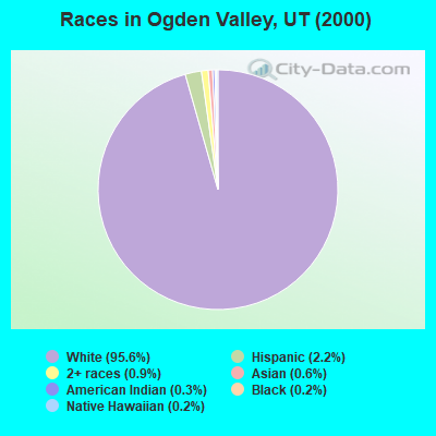
- 5,61895.6%White alone
- 1322.2%Hispanic
- 510.9%Two or more races
- 340.6%Asian alone
- 190.3%American Indian alone
- 100.2%Black alone
- 90.2%Native Hawaiian and Other
Pacific Islander alone - 40.07%Other race alone
Races in Ogden Valley detailed stats: ancestries, foreign born residents, place of birth
 Recent articles from our blog. Our writers, many of them Ph.D. graduates or candidates, create easy-to-read articles on a wide variety of topics.

Current Local Time: MST time zone
Land area: 347.5 square miles.
Population density: 19 people per square mile (very low).

| Ogden Valley CCD: | 0.5% ($1,203) |
| Utah: | 0.7% ($956) |
Nearest city with pop. 50,000+: Ogden, UT  (12.9 miles , pop. 77,226).
Nearest city with pop. 200,000+: Northeast Jefferson, CO (364.5 miles , pop. 450,166).
Nearest city with pop. 1,000,000+: Phoenix, AZ (538.1 miles , pop. 1,321,045).
Nearest cities:
), ), ), ), )Latitude: 41.30 N, Longitude: 111.73 W
Area code commonly used in this area: 801

| Here: | 2.7% |
| Utah: | 2.5% |

- Public administration (12.2%)
- Construction (12.0%)
- Educational services (11.2%)
- Health care (8.3%)
- Accommodation & food services (6.8%)
- Transportation equipment (4.7%)
- Professional, scientific, technical services (4.3%)
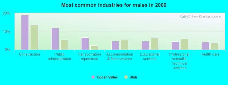
- Construction (18.9%)
- Public administration (11.8%)
- Transportation equipment (6.6%)
- Accommodation & food services (4.6%)
- Educational services (4.6%)
- Professional, scientific, technical services (4.6%)
- Health care (4.2%)
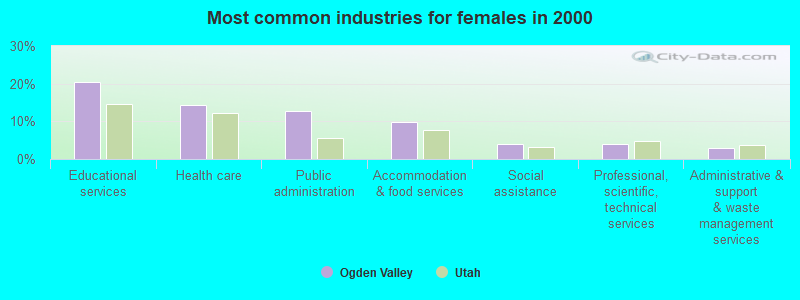
- Educational services (20.4%)
- Health care (14.2%)
- Public administration (12.7%)
- Accommodation & food services (9.8%)
- Social assistance (3.9%)
- Professional, scientific, technical services (3.9%)
- Administrative & support & waste management services (3.0%)
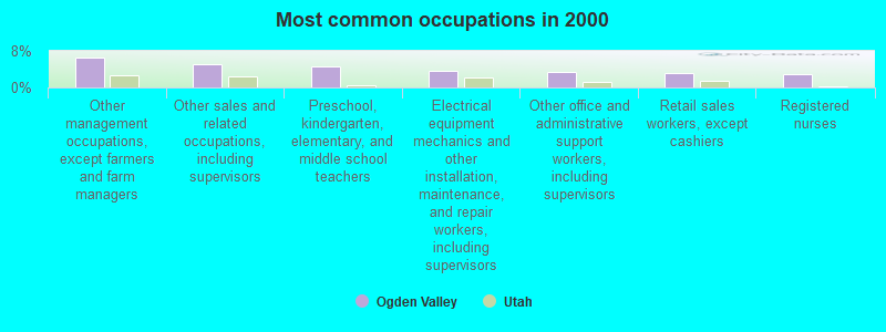
- Other management occupations, except farmers and farm managers (6.6%)
- Other sales and related occupations, including supervisors (5.2%)
- Preschool, kindergarten, elementary, and middle school teachers (4.6%)
- Electrical equipment mechanics and other installation, maintenance, and repair workers, including supervisors (3.6%)
- Other office and administrative support workers, including supervisors (3.3%)
- Retail sales workers, except cashiers (3.2%)
- Registered nurses (2.9%)
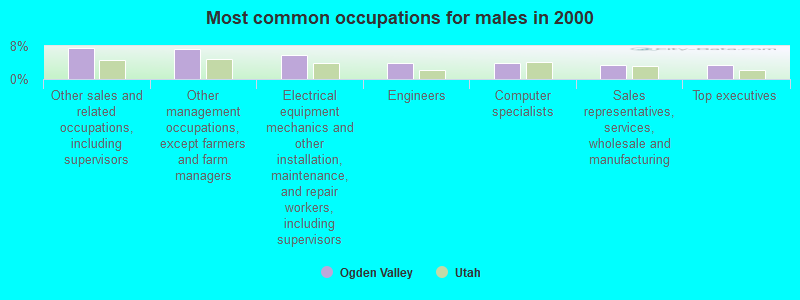
- Other sales and related occupations, including supervisors (7.5%)
- Other management occupations, except farmers and farm managers (7.2%)
- Electrical equipment mechanics and other installation, maintenance, and repair workers, including supervisors (5.7%)
- Engineers (4.0%)
- Computer specialists (4.0%)
- Sales representatives, services, wholesale and manufacturing (3.4%)
- Top executives (3.4%)
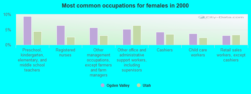
- Preschool, kindergarten, elementary, and middle school teachers (9.4%)
- Registered nurses (6.4%)
- Other management occupations, except farmers and farm managers (5.6%)
- Other office and administrative support workers, including supervisors (5.1%)
- Cashiers (4.2%)
- Child care workers (3.7%)
- Retail sales workers, except cashiers (3.1%)
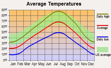
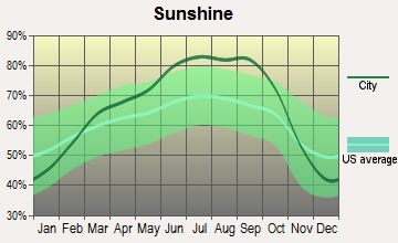
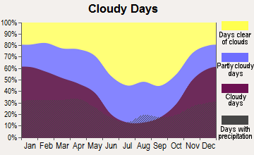
Average climate in Ogden Valley, Utah
Based on data reported by over 4,000 weather stations
(lower is better)
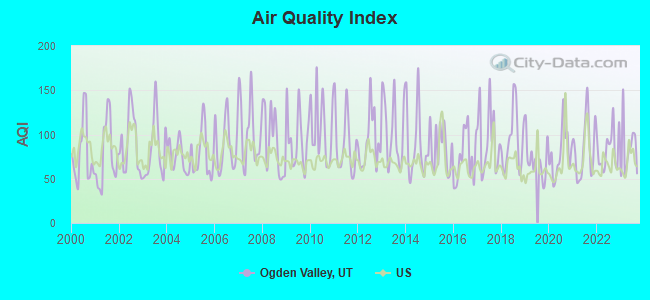
Air Quality Index (AQI) level in 2023 was 83.5. This is about average.
| City: | 83.5 |
| U.S.: | 72.6 |
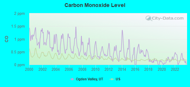
Carbon Monoxide (CO) [ppm] level in 2023 was 0.219. This is about average. Closest monitor was 13.2 miles away from the city center.
| City: | 0.219 |
| U.S.: | 0.251 |
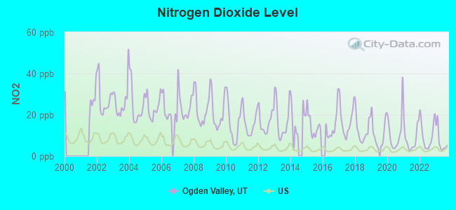
Nitrogen Dioxide (NO2) [ppb] level in 2023 was 7.29. This is significantly worse than average. Closest monitor was 13.2 miles away from the city center.
| City: | 7.29 |
| U.S.: | 5.11 |
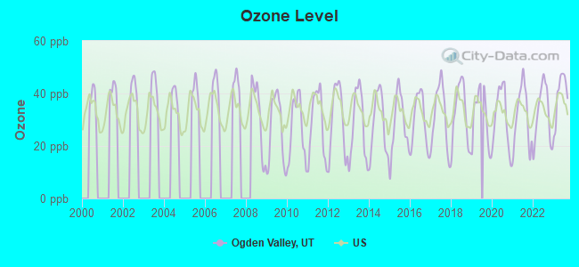
Ozone [ppb] level in 2023 was 39.5. This is about average. Closest monitor was 13.2 miles away from the city center.
| City: | 39.5 |
| U.S.: | 33.3 |
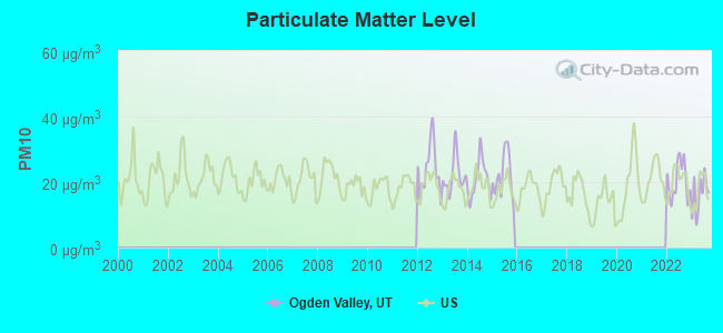
Particulate Matter (PM10) [µg/m3] level in 2023 was 16.2. This is about average. Closest monitor was 13.2 miles away from the city center.
| City: | 16.2 |
| U.S.: | 19.2 |
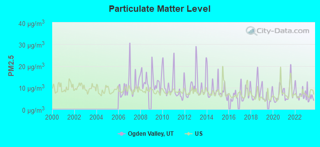
Particulate Matter (PM2.5) [µg/m3] level in 2023 was 5.79. This is significantly better than average. Closest monitor was 13.2 miles away from the city center.
| City: | 5.79 |
| U.S.: | 8.11 |
Earthquake activity:
Ogden Valley-area historical earthquake activity is significantly above Utah state average. It is 2032% greater than the overall U.S. average.On 8/18/1959 at 06:37:13, a magnitude 7.7 (7.7 UK, Class: Major, Intensity: VIII - XII) earthquake occurred 232.1 miles away from the city center, causing $26,000,000 total damage
On 10/28/1983 at 14:06:06, a magnitude 7.3 (6.2 MB, 7.3 MS, 7.0 MW) earthquake occurred 218.7 miles away from Ogden Valley center, causing 2 deaths (2 shaking deaths) and 3 injuries, causing $15,000,000 total damage
On 10/3/1915 at 06:52:48, a magnitude 7.6 (7.6 UK) earthquake occurred 306.5 miles away from Ogden Valley center
On 3/28/1975 at 02:31:05, a magnitude 6.2 (6.1 MB, 6.0 MS, 6.2 ML, Class: Strong, Intensity: VII - IX) earthquake occurred 62.2 miles away from Ogden Valley center
On 3/18/2020 at 13:09:31, a magnitude 5.7 (5.7 MW, Depth: 7.4 mi, Class: Moderate, Intensity: VI - VII) earthquake occurred 42.3 miles away from the city center
On 12/21/1932 at 06:10:09, a magnitude 7.2 (7.2 UK) earthquake occurred 388.3 miles away from the city center
Magnitude types: body-wave magnitude (MB), local magnitude (ML), surface-wave magnitude (MS), moment magnitude (MW)
Natural disasters:
The number of natural disasters in Weber County (8) is smaller than the US average (15).Major Disasters (Presidential) Declared: 4
Emergencies Declared: 2
Causes of natural disasters: Floods: 4, Landslides: 2, Storms: 2, Drought: 1, Fire: 1, Heavy Rain: 1, Hurricane: 1, Mudslide: 1, Snow: 1, Other: 1 (Note: some incidents may be assigned to more than one category).
Hospitals and medical centers near Ogden Valley:
- SPECIALTY NURSING SERVICES, INC (Home Health Center, about 4 miles away; HUNTSVILLE, UT)
- GEORGE E WAHLEN OGDEN VETERANS HOME (Nursing Home, about 12 miles away; OGDEN, UT)
- TRINITY MISSION WIDE HORIZONS RES CARE FACILITY (Hospital, about 13 miles away; OGDEN, UT)
- LOMOND PEAK CARE AND REHAB (Nursing Home, about 13 miles away; OGDEN, UT)
- PINE VIEW TRANSITIONAL REHAB (Nursing Home, about 13 miles away; OGDEN, UT)
- ASPEN CARE CENTER (Nursing Home, about 14 miles away; OGDEN, UT)
- KINDRED NURSING AND REHABILITATION - WASATCH CARE (Nursing Home, about 14 miles away; OGDEN, UT)
Colleges/universities with over 2000 students nearest to Ogden Valley:
- Weber State University (about 14 miles; Ogden, UT; Full-time enrollment: 17,655)
- Utah State University (about 31 miles; Logan, UT; FT enrollment: 21,131)
- Latter-day Saints Business College (about 38 miles; Salt Lake City, UT; FT enrollment: 2,059)
- University of Utah (about 38 miles; Salt Lake City, UT; FT enrollment: 28,454)
- Westminster College (about 41 miles; Salt Lake City, UT; FT enrollment: 2,870)
- Western Governors University (about 44 miles; Salt Lake City, UT; FT enrollment: 31,481)
- Salt Lake Community College (about 46 miles; Salt Lake City, UT; FT enrollment: 20,797)
Points of interest:
Notable locations in Ogden Valley: Maples Picnic Area (A), Jefferson Hunt Campground (B), North Arm Campground (C), Bluffs Recreation Site (D), Snow Basin Ski Area (E), Skull Crack Campground (F), North Ogden Canyon Trail Head (G), Nordic Valley Ski Area (H), Hawthorne Campground (I), Ben Lomond Camp (J), Anderson Cove Campground (K), South Fork Picnic Ground (L), Meadows Campground (M), Meadows Picnic Ground (N), Wildcat Campground (O), Red Rock Ranch (P), South Arm Campground (Q), Perception Park Campground (R), Botts Flat Picnic Ground (S), Camp Kiesel (T). Display/hide their locations on the map
Churches in Ogden Valley include: Ogden Rescue Mission (A), The Church of Jesus Christ of Latter Day Saints (B). Display/hide their locations on the map
Cemeteries: Meadow View Cemetery (1), Huntsville Cemetery (2), Mountain View Cemetery (3). Display/hide their locations on the map
Lakes and reservoirs: Lower Dry Bread Pond (A), Green Pond (B), Huntsville Reservoir (C), Pineview Reservoir (D), Causey Reservoir (E), Utaba Reservoir (F). Display/hide their locations on the map
Streams, rivers, and creeks: Gertsen Creek (A), Durfee Creek (B), Sheep Herd Creek (C), Sheep Creek (D), Union Creek (E), Goodale Creek (F), Thimbleberry Creek (G), Spring Creek (H), Rock Creek (I). Display/hide their locations on the map
Parks in Ogden Valley include: Hill Air Force Base Recreation Area (1), Weber County North Fork Park (2), Weber County Memorial Park (3), Evergreen Park (4). Display/hide their locations on the map
| This place: | 3.0 people |
| Utah: | 3.1 people |
| This place: | 81.8% |
| Whole state: | 75.2% |
| This place: | 3.5% |
| Whole state: | 4.6% |
Likely homosexual households (counted as self-reported same-sex unmarried-partner households)
- Lesbian couples: 0.2% of all households
- Gay men: 0.4% of all households
| This place: | 4.2% |
| Whole state: | 9.4% |
| This place: | 1.0% |
| Whole state: | 3.9% |
21 people in religious group quarters in 2000
For population 15 years and over in Ogden Valley:
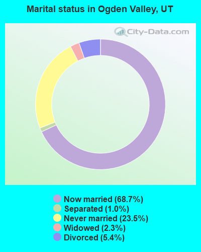
- Never married: 23.5%
- Now married: 68.7%
- Separated: 1.0%
- Widowed: 2.3%
- Divorced: 5.4%
For population 25 years and over in Ogden Valley:
- High school or higher: 94.4%
- Bachelor's degree or higher: 34.2%
- Graduate or professional degree: 12.7%
- Unemployed: 3.9%
- Mean travel time to work (commute): 32.7 minutes

| Here: | 9.0 |
| Utah average: | 10.5 |
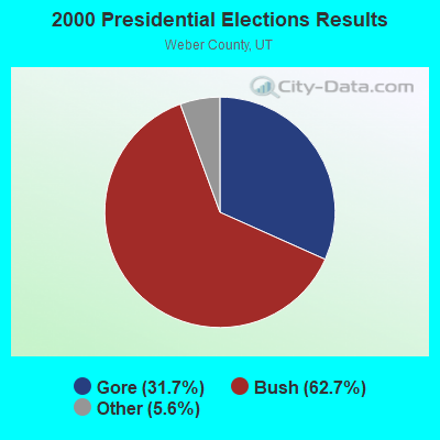
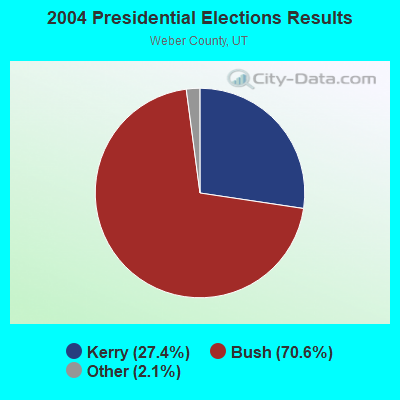
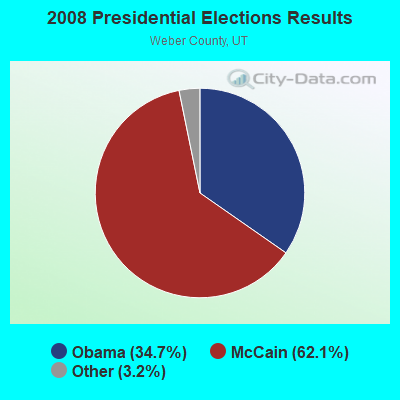
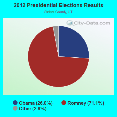
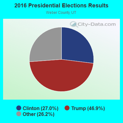

Graphs represent county-level data. Detailed 2008 Election Results
Religion statistics for Ogden Valley, UT (based on Weber County data)
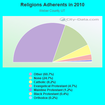
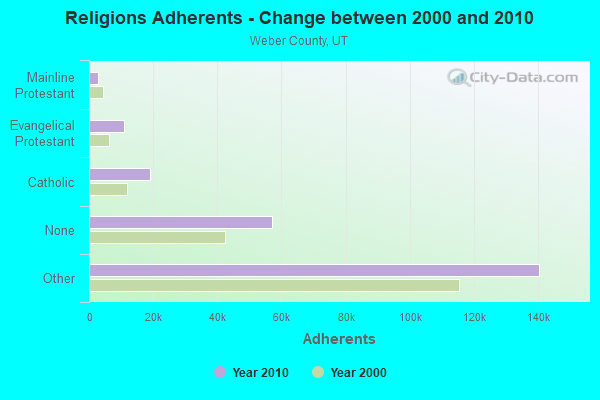
| Religion | Adherents | Congregations |
|---|---|---|
| Other | 140,427 | 324 |
| Catholic | 18,933 | 6 |
| Evangelical Protestant | 10,761 | 52 |
| Mainline Protestant | 2,761 | 11 |
| Black Protestant | 887 | 4 |
| Orthodox | 350 | 1 |
| None | 57,117 | - |
Food Environment Statistics:
| This county: | 1.35 / 10,000 pop. |
| Utah: | 1.37 / 10,000 pop. |
| This county: | 0.23 / 10,000 pop. |
| Utah: | 0.18 / 10,000 pop. |
| This county: | 0.72 / 10,000 pop. |
| State: | 0.41 / 10,000 pop. |
| This county: | 2.62 / 10,000 pop. |
| State: | 2.82 / 10,000 pop. |
| Here: | 4.79 / 10,000 pop. |
| Utah: | 5.09 / 10,000 pop. |
| This county: | 7.1% |
| State: | 6.3% |
| Weber County: | 25.7% |
| Utah: | 23.6% |
8.58% of this county's 2021 resident taxpayers lived in other counties in 2020 ($63,347 average adjusted gross income)
| Here: | 8.58% |
| Utah average: | 7.95% |
0.06% of residents moved from foreign countries ($419 average AGI)
Weber County: 0.06% Utah average: 0.02%
Top counties from which taxpayers relocated into this county between 2020 and 2021:
| from Davis County, UT | |
| from Salt Lake County, UT | |
| from Box Elder County, UT |
7.73% of this county's 2020 resident taxpayers moved to other counties in 2021 ($55,300 average adjusted gross income)
| Here: | 7.73% |
| Utah average: | 7.39% |
0.04% of residents moved to foreign countries ($368 average AGI)
Weber County: 0.04% Utah average: 0.02%
Top counties to which taxpayers relocated from this county between 2020 and 2021:
| to Davis County, UT | |
| to Salt Lake County, UT | |
| to Box Elder County, UT |
Strongest AM radio stations in Ogden Valley:
- KALL (700 AM; 50 kW; NORTH SALT LAKE CITY, UT; Owner: CITICASTERS LICENSES, L.P.)
- KIQN (1010 AM; 50 kW; TOOELE, UT)
- KSOS (800 AM; 10 kW; BRIGHAM CITY, UT; Owner: SIMMONS-SLC, LS, LLC)
- KSL (1160 AM; 50 kW; SALT LAKE CITY, UT; Owner: BONNEVILLE HOLDING COMPANY)
- KXOL (1660 AM; 10 kW; BRIGHAM CITY, UT; Owner: SIMMONS-SLC, LS, LLC)
- KANN (1120 AM; 10 kW; ROY, UT; Owner: FAITH COMMUNICATIONS CORPORATION)
- KLO (1430 AM; 10 kW; OGDEN, UT; Owner: KLO BROADCASTING CO.)
- KVNU (610 AM; 5 kW; LOGAN, UT; Owner: SUN VALLEY RADIO,INC.)
- KTKK (630 AM; 10 kW; SANDY, UT; Owner: UNITED BROADCASTING COMPANY)
- KZNS (1280 AM; 10 kW; SALT LAKE CITY, UT; Owner: SIMMONS-SLC, LS, LLC)
- KNRS (570 AM; 5 kW; SALT LAKE CITY, UT; Owner: CITICASTERS LICENSES, L.P.)
- KBEE (860 AM; 10 kW; SALT LAKE CITY, UT; Owner: CITADEL BROADCASTING COMPANY)
- KLGN (1390 AM; 5 kW; LOGAN, UT; Owner: SUN VALLEY RADIO, INC.)
Strongest FM radio stations in Ogden Valley:
- KCPX (105.7 FM; CENTERVILLE, UT; Owner: MERCURY BROADCASTING COMPANY, INC.)
- KYFO-FM (95.5 FM; OGDEN, UT; Owner: BIBLE BROADCASTING NETWORK, INC.)
- KCUA (92.5 FM; COALVILLE, UT; Owner: COMMUNITY WIRELESS OF PARK CITY, INC)
- KBZN-FM1 (97.9 FM; PARK CITY, UT; Owner: CAPITOL BROADCASTING INC.)
- K201AE (88.1 FM; COALVILLE, ETC., UT; Owner: COMMUNITY WIRELESS OF PARK CITY, INC)
- KZHT-FM1 (94.9 FM; PARK CITY, UT; Owner: CITICASTERS LICENSES, L.P.)
- KSOP-FM (104.3 FM; SALT LAKE CITY, UT; Owner: KSOP, INC.)
- K272DP (102.3 FM; TOOELE, UT; Owner: FAMILY STATIONS, INC.)
- KBZN (97.9 FM; OGDEN, UT; Owner: CAPITOL BROADCASTING, INC.)
- KRCL (90.9 FM; SALT LAKE CITY, UT; Owner: LISTENERS COMMUNITY RADIO OF UTAH)
- KBER (101.1 FM; OGDEN, UT; Owner: CITADEL BROADCASTING COMPANY)
- KISN-FM (97.1 FM; SALT LAKE CITY, UT; Owner: CLEAR CHANNEL BROADCASTING LICENSES, INC.)
- KKAT (101.9 FM; OGDEN, UT; Owner: CITICASTERS LICENSES, L.P.)
- KSFI (100.3 FM; SALT LAKE CITY, UT; Owner: SIMMONS-SLC, LS, LLC)
- KUBL-FM (93.3 FM; SALT LAKE CITY, UT; Owner: CITADEL BROADCASTING COMPANY)
- KOSY-FM (106.5 FM; SPANISH FORK, UT; Owner: MERCURY BROADCASTING COMPANY, INC.)
- KRSP-FM (103.5 FM; SALT LAKE CITY, UT; Owner: SIMMONS-SLC, LS, LLC)
- KUDD (107.9 FM; ROY, UT; Owner: MILLCREEK BROADCASTING, L.L.C.)
- KRAR (106.9 FM; BRIGHAM CITY, UT; Owner: MERCURY BROADCASTING COMPANY, INC.)
- KODJ (94.1 FM; SALT LAKE CITY, UT; Owner: CITICASTERS LICENSES, L.P.)
TV broadcast stations around Ogden Valley:
- K59BV (Channel 59; LAVA HOT SPRINGS, ID; Owner: STATE BOARD OF EDUCATION (IEPBS))
- K48EI (Channel 48; HUNTSVILLE, LIBERTY,, UT; Owner: WEBER CTY.-OGDEN VALLEY RECREATION)
- K46EB (Channel 46; HUNTSVILLE, ETC., UT; Owner: WEBER CTY.-OGDEN VALLEY RECREATION)
- K35GG (Channel 35; HUNTSVILLE, ETC., UT; Owner: UNIVERSITY OF UTAH)
- K50EB (Channel 50; HUNTSVILLE, ETC., UT; Owner: WEBER CTY.-OGDEN VALLEY RECREATION)
- K52CS (Channel 52; HUNTSVILLE, ETC., UT; Owner: WEBER CTY.-OGDEN VALLEY RECREATION)
- KULX-CA (Channel 51; OGDEN, UT; Owner: AIRWAVES, INC.)
- K58FT (Channel 58; HUNTSVILLE, UT; Owner: ALPHA & OMEGA COMMUNICATIONS, L.L.C.)
- KSVN-CA (Channel 49; OGDEN, UT; Owner: AZTECA BROADCASTING CORPORATION)
- K08DI (Channel 8; HUNTSVILLE, ETC., UT; Owner: OGDEN VALLEY TV REPEATER ASSOCIATION)
- K10DT (Channel 10; HUNTSVILLE, ETC., UT; Owner: WEBER CTY.-OGDEN VALLEY RECREATION)
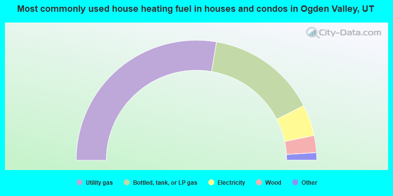
- 55.3%Utility gas
- 29.6%Bottled, tank, or LP gas
- 8.4%Electricity
- 4.6%Wood
- 1.5%Fuel oil, kerosene, etc.
- 0.4%Other fuel
- 0.1%Coal or coke
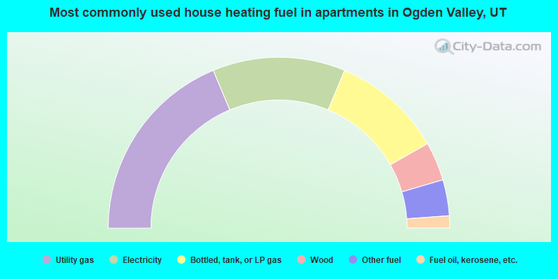
- 37.4%Utility gas
- 25.1%Electricity
- 21.0%Bottled, tank, or LP gas
- 7.3%Wood
- 6.8%Other fuel
- 2.3%Fuel oil, kerosene, etc.
Ogden Valley compared to Utah state average:
- Median house value above state average.
- Unemployed percentage significantly below state average.
- Black race population percentage significantly below state average.
- Hispanic race population percentage significantly below state average.
- Median age above state average.
- Foreign-born population percentage significantly below state average.
- Renting percentage below state average.
- Length of stay since moving in significantly above state average.
- Number of rooms per house significantly below state average.
- House age significantly below state average.
Ogden Valley on our top lists:
- #17 on the list of "Top 101 cities with largest percentage of females in occupations: electricians (population 5,000+)"
- #24 on the list of "Top 101 cities with largest percentage of females in occupations: judges, magistrates, and other judicial workers (population 5,000+)"
- #29 on the list of "Top 101 cities with largest percentage of males in industries: sporting goods, camera, and hobby and toy stores (population 5,000+)"
- #34 on the list of "Top 101 cities with largest percentage of females in occupations: preschool, kindergarten, elementary and middle school teachers (population 5,000+)"
- #37 on the list of "Top 101 cities with largest percentage of males in occupations: other sales and related workers including supervisors (population 5,000+)"
- #43 on the list of "Top 100 highest located cities (pop. 50,000+)"
- #44 on the list of "Top 101 cities with largest percentage of females in industries: data processing, libraries, and other information services (population 5,000+)"
- #47 on the list of "Top 101 cities with largest percentage of males in occupations: air transportation workers (population 5,000+)"
- #49 on the list of "Top 101 cities with largest percentage of females in industries: furniture and related product manufacturing (population 5,000+)"
- #58 on the list of "Top 101 cities with largest percentage of females in occupations: other financial specialists (population 5,000+)"
- #63 on the list of "Top 101 cities with largest percentage of males in industries: sewing, needlework, and piece goods stores (population 5,000+)"
- #65 on the list of "Top 101 cities with largest percentage of males in industries: health and personal care, except drug, stores (population 5,000+)"
- #83 on the list of "Top 101 cities with largest percentage of males in industries: book stores and news dealers (population 5,000+)"
- #91 on the list of "Top 101 cities with largest percentage of males in industries: electronic shopping and mail-order houses (population 5,000+)"
- #96 on the list of "Top 101 cities with largest percentage of males in industries: farm supplies merchant wholesalers (population 5,000+)"
- #8 on the list of "Top 101 counties with the lowest percentage of residents that smoked 100+ cigarettes in their lives"
- #11 on the list of "Top 101 counties with the most Other congregations"
- #13 on the list of "Top 101 counties with the highest Nitrogen Dioxide air pollution readings in 2012 (ppm)"
- #14 on the list of "Top 101 counties with the lowest percentage of residents that drank alcohol in the past 30 days"
- #15 on the list of "Top 101 counties with the highest number of births per 1000 residents 2007-2013"