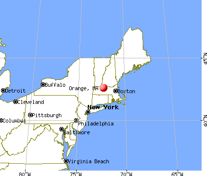
Orange, Massachusetts
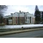
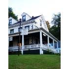
Orange: Orange Massachusetts Large Home on East Main Street

Orange: Orange Peace Statue
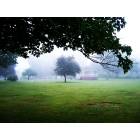
Orange: Orange Town Park
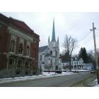
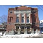
Orange: Orange Massachusetts Town Hall Church and Historical Society
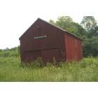
Orange: Orange Town Farm
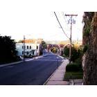
Orange: Overlooking Orange From North Main Street
Orange: Orange Historical Society
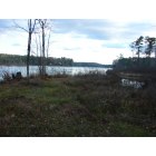
Orange: Serene Eagleville Pond, about 3 1/2 miles long. Land for sale here.
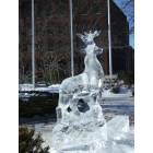
Orange: Orange Starry Night 2008 Ice Sculpture
Orange: Orange Town Hall
- add
your


Submit your own pictures of this place and show them to the world
- OSM Map
- General Map
- Google Map
- MSN Map
Population change since 2000: +1.9%
| Males: 1,973 | |
| Females: 2,045 |
| Median resident age: | 41.5 years |
| Massachusetts median age: | 40.3 years |
Zip codes: 01364.
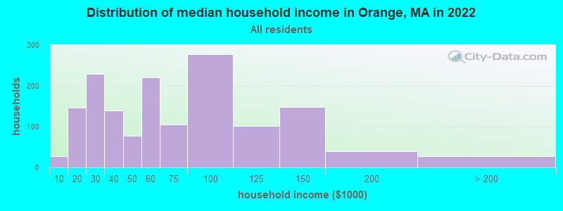
| Orange: | $55,497 |
| MA: | $94,488 |
Estimated per capita income in 2022: $26,671 (it was $15,550 in 2000)
Orange CDP income, earnings, and wages data
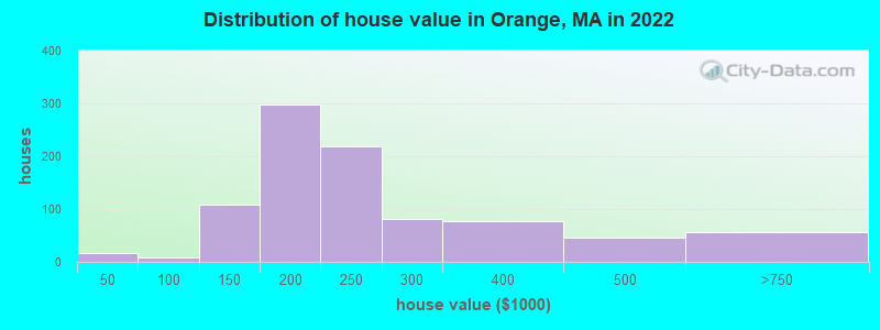
Estimated median house or condo value in 2022: $216,001 (it was $84,500 in 2000)
| Orange: | $216,001 |
| MA: | $534,700 |
Mean prices in 2022: all housing units: $313,377; detached houses: $324,224; townhouses or other attached units: $284,225; in 2-unit structures: $287,978; in 3-to-4-unit structures: $183,938; in 5-or-more-unit structures: $249,762; mobile homes: $62,200
Median gross rent in 2022: $889.
(17.7% for White Non-Hispanic residents, 85.7% for Black residents, 13.1% for Hispanic or Latino residents, 13.2% for two or more races residents)
Detailed information about poverty and poor residents in Orange, MA
Compare current foreclosures near Orange, MA:
| Photo | Address | Area | Beds / Baths | Price | Details |
|---|---|---|---|---|---|

|
#1
Butterworth Rd
Orange, MA 01364
|
896 sq. feet
|
2 baths 2 beds |
show details | |

|
#2
E River St
Orange, MA 01364
|
1,332 sq. feet
|
1 baths 3 beds |
show details | |

|
#3
Wheeler Ave
Orange, MA 01364
|
1,863 sq. feet
|
2 baths 3 beds |
show details | |

|
#4
Maynard St
Orange, MA 01364
|
1,640 sq. feet
|
2 baths 3 beds |
show details | |

|
#5
Prescott Ln
Orange, MA 01364
|
2,064 sq. feet
|
2 baths 3 beds |
show details | |

|
#6
Lake Mattawa Rd
Orange, MA 01364
|
1,666 sq. feet
|
1 baths 3 beds |
show details | |

|
#7
Eddy St
Orange, MA 01364
|
1,116 sq. feet
|
1 baths 2 beds |
show details | |

|
#8
W River St
Orange, MA 01364
|
- sq. feet
|
- baths - beds |
show details | |

|
#9
S Main St # 1
Orange, MA 01364
|
- sq. feet
|
- baths - beds |
show details | |

|
#10
E River St Apt 912
Orange, MA 01364
|
- sq. feet
|
- baths - beds |
show details |
| Photo | Address | Area | Beds / Baths | Price | Details |
|---|---|---|---|---|---|

|
#11
East St
Orange, MA 01364
|
- sq. feet
|
- baths - beds |
show details | |

|
#12
Whipple Hill Rd
Winchester, NH 03470
|
1,374 sq. feet
|
2 baths 2 beds |
$379,900
|
show details |

|
#13
Lampblack Rd
Greenfield, MA 01301
|
2,078 sq. feet
|
1 baths 3 beds |
$379,900
|
show details |

|
#14
Parker St
Gardner, MA 01440
|
1,980 sq. feet
|
2 baths 4 beds |
$469,900
|
show details |

|
#15
Tully Rd
Orange, MA 01364
|
- sq. feet
|
- baths - beds |
show details | |

|
#16
Walnut St
Athol, MA 01331
|
1,600 sq. feet
|
1 baths 2 beds |
show details | |

|
#17
N Orange Rd
Athol, MA 01331
|
950 sq. feet
|
1 baths 3 beds |
show details | |

|
#18
West St
Greenfield, MA 01301
|
1,858 sq. feet
|
2 baths 3 beds |
show details | |

|
#19
Athol Richmond Rd
Royalston, MA 01368
|
2,000 sq. feet
|
2 baths 3 beds |
show details | |

|
#20
Chapman St
Greenfield, MA 01301
|
- sq. feet
|
1 baths 3 beds |
show details |
| Photo | Address | Area | Beds / Baths | Price | Details |
|---|---|---|---|---|---|

|
#21
Summer St
Gardner, MA 01440
|
1,893 sq. feet
|
2 baths 5 beds |
show details | |

|
#22
Chapman St
Greenfield, MA 01301
|
1,472 sq. feet
|
1 baths 2 beds |
show details | |

|
#23
Maple St
Winchendon, MA 01475
|
903 sq. feet
|
1 baths 2 beds |
show details | |

|
#24
Braeburn Rd
South Deerfield, MA 01373
|
1,661 sq. feet
|
1 baths 3 beds |
show details | |

|
#25
Barthel Ave
Gardner, MA 01440
|
1,007 sq. feet
|
1 baths 2 beds |
show details | |

|
#26
Elm St
Greenfield, MA 01301
|
1,160 sq. feet
|
1 baths 3 beds |
show details | |

|
#27
Central St
Winchendon, MA 01475
|
1,685 sq. feet
|
1 baths 3 beds |
show details | |

|
#28
Teel Rd
Winchendon, MA 01475
|
1,080 sq. feet
|
1 baths 3 beds |
show details | |

|
#29
Meridian St
Greenfield, MA 01301
|
768 sq. feet
|
1 baths 2 beds |
show details | |

|
#30
Juniper St
Winchendon, MA 01475
|
1,687 sq. feet
|
1 baths 4 beds |
show details |
| Photo | Address | Area | Beds / Baths | Price | Details |
|---|---|---|---|---|---|

|
#31
West St
Gardner, MA 01440
|
1,320 sq. feet
|
2 baths 3 beds |
show details | |

|
#32
Garfield St
Greenfield, MA 01301
|
2,260 sq. feet
|
2 baths 4 beds |
show details | |

|
#33
Spruce St
Winchendon, MA 01475
|
1,504 sq. feet
|
1 baths 3 beds |
show details | |

|
#34
Hope St
Greenfield, MA 01301
|
1,619 sq. feet
|
1 baths 3 beds |
show details | |

|
#35
Forest Ave
Greenfield, MA 01301
|
1,764 sq. feet
|
1 baths 4 beds |
show details | |

|
#36
School St
Winchendon, MA 01475
|
1,518 sq. feet
|
1 baths 3 beds |
show details | |

|
#37
James St
Greenfield, MA 01301
|
2,176 sq. feet
|
2 baths 4 beds |
show details | |

|
#38
Chelsea St
Gardner, MA 01440
|
1,287 sq. feet
|
1 baths 3 beds |
show details | |

|
#39
Maple St
Greenfield, MA 01301
|
1,216 sq. feet
|
1 baths 3 beds |
show details | |

|
#40
West St
Winchendon, MA 01475
|
1,584 sq. feet
|
1 baths 3 beds |
show details |
| Photo | Address | Area | Beds / Baths | Price | Details |
|---|---|---|---|---|---|

|
#41
Hill St
Winchendon, MA 01475
|
1,549 sq. feet
|
1 baths 3 beds |
show details | |

|
#42
French King Hwy
Greenfield, MA 01301
|
1,040 sq. feet
|
1 baths 5 beds |
show details | |

|
#43
Wauwinet Rd
Barre, MA 01005
|
2,560 sq. feet
|
2 baths 5 beds |
show details | |

|
#44
Greenwood Pl
Gardner, MA 01440
|
1,206 sq. feet
|
1 baths 2 beds |
show details | |

|
#45
Ash St
Winchendon, MA 01475
|
960 sq. feet
|
1 baths 2 beds |
show details | |

|
#46
Pine St
Amherst, MA 01002
|
2,195 sq. feet
|
2 baths 4 beds |
show details | |

|
#47
Prospect St
Gardner, MA 01440
|
1,357 sq. feet
|
2 baths 3 beds |
show details | |

|
#48
Brattleboro Rd
Hinsdale, NH 03451
|
1,150 sq. feet
|
1 baths 2 beds |
show details | |

|
#49
N Main St
South Deerfield, MA 01373
|
2,143 sq. feet
|
1 baths 5 beds |
show details | |

|
Check over 1 million property listings on Foreclosure.com!
|
browse all offers | |||


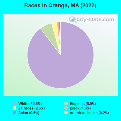
- 3,33989.6%White alone
- 2205.9%Hispanic
- 982.6%Two or more races
- 391.0%Black alone
- 210.6%Asian alone
- 90.2%American Indian alone
Races in Orange detailed stats: ancestries, foreign born residents, place of birth
According to our research of Massachusetts and other state lists, there were 13 registered sex offenders living in Orange, Massachusetts as of April 25, 2024.
The ratio of all residents to sex offenders in Orange is 320 to 1.
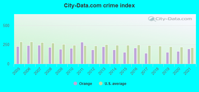
Type |
2009 |
2010 |
2011 |
2012 |
2013 |
2014 |
2015 |
2016 |
2017 |
2018 |
2019 |
2020 |
2021 |
|---|---|---|---|---|---|---|---|---|---|---|---|---|---|
| Murders (per 100,000) | 0 (0.0) | 0 (0.0) | 0 (0.0) | 0 (0.0) | 0 (0.0) | 0 (0.0) | 0 (0.0) | 1 (13.1) | 0 (0.0) | 0 (0.0) | 0 (0.0) | 0 (0.0) | 0 (0.0) |
| Rapes (per 100,000) | 2 (25.3) | 2 (25.5) | 4 (50.7) | 2 (25.2) | 6 (76.7) | 2 (25.8) | 4 (52.1) | 6 (78.8) | 1 (13.2) | 0 (0.0) | 4 (52.3) | 5 (66.2) | 5 (66.2) |
| Robberies (per 100,000) | 3 (37.9) | 3 (38.3) | 2 (25.4) | 3 (37.8) | 3 (38.4) | 2 (25.8) | 2 (26.0) | 2 (26.3) | 0 (0.0) | 0 (0.0) | 2 (26.2) | 0 (0.0) | 4 (52.9) |
| Assaults (per 100,000) | 21 (265.3) | 19 (242.4) | 32 (405.7) | 16 (201.7) | 17 (217.4) | 18 (232.6) | 13 (169.2) | 17 (223.2) | 22 (290.7) | 0 (0.0) | 17 (222.4) | 15 (198.6) | 22 (291.2) |
| Burglaries (per 100,000) | 56 (707.5) | 70 (893.0) | 111 (1,407) | 66 (831.9) | 52 (665.1) | 65 (840.1) | 41 (533.6) | 28 (367.7) | 38 (502.0) | 0 (0.0) | 17 (222.4) | 19 (251.5) | 13 (172.0) |
| Thefts (per 100,000) | 102 (1,289) | 104 (1,327) | 95 (1,205) | 98 (1,235) | 111 (1,420) | 90 (1,163) | 58 (754.9) | 66 (866.7) | 62 (819.1) | 1 (13.1) | 72 (942.0) | 90 (1,191) | 89 (1,178) |
| Auto thefts (per 100,000) | 4 (50.5) | 8 (102.1) | 6 (76.1) | 3 (37.8) | 4 (51.2) | 4 (51.7) | 1 (13.0) | 6 (78.8) | 4 (52.8) | 0 (0.0) | 4 (52.3) | 7 (92.7) | 7 (92.6) |
| Arson (per 100,000) | 2 (25.3) | 0 (0.0) | 1 (12.7) | 1 (12.6) | 4 (51.2) | 3 (38.8) | 1 (13.0) | 1 (13.1) | 1 (13.2) | 0 (0.0) | 1 (13.1) | 2 (26.5) | 0 (0.0) |
| City-Data.com crime index | 189.8 | 204.1 | 282.1 | 182.5 | 223.8 | 184.4 | 151.9 | 208.5 | 140.8 | 0.5 | 151.6 | 165.3 | 193.6 |
The City-Data.com crime index weighs serious crimes and violent crimes more heavily. Higher means more crime, U.S. average is 246.1. It adjusts for the number of visitors and daily workers commuting into cities.
Crime rate in Orange detailed stats: murders, rapes, robberies, assaults, burglaries, thefts, arson
Full-time law enforcement employees in 2019, including police officers: 14 (13 officers - 12 male; 1 female).
| Officers per 1,000 residents here: | 1.70 |
| Massachusetts average: | 2.59 |
 Recent articles from our blog. Our writers, many of them Ph.D. graduates or candidates, create easy-to-read articles on a wide variety of topics.


Latest news from Orange, MA collected exclusively by city-data.com from local newspapers, TV, and radio stations
Ancestries: American (16.3%), French Canadian (16.1%), English (7.9%), Irish (7.0%), Italian (6.9%), French (6.0%).
Current Local Time: EST time zone
Incorporated in 1810
Elevation: 510 feet
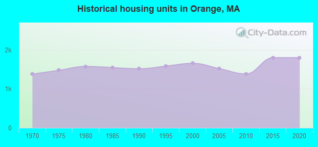
Land area: 6.00 square miles.
Population density: 669 people per square mile (low).
203 residents are foreign born (2.0% Latin America, 1.8% Europe).
| This place: | 5.4% |
| Massachusetts: | 17.6% |
Median real estate property taxes paid for housing units with mortgages in 2022: $3,593 (1.6%)
Median real estate property taxes paid for housing units with no mortgage in 2022: $3,232 (1.7%)
Nearest city with pop. 50,000+: Chicopee, MA  (32.2 miles , pop. 54,653).
Nearest city with pop. 200,000+: Boston, MA (64.9 miles , pop. 589,141).
Nearest city with pop. 1,000,000+: Bronx, NY (145.0 miles , pop. 1,332,650).
Nearest cities:
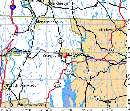
), ), Latitude: 42.59 N, Longitude: 72.31 W
Area code: 978

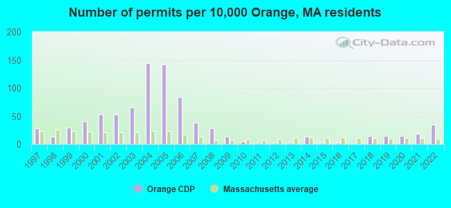
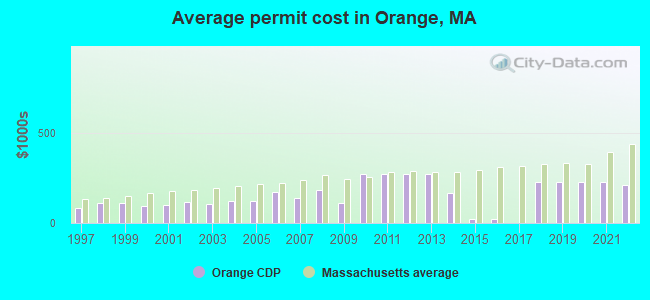
Single-family new house construction building permits:
- 2022: 14 buildings, average cost: $211,500
- 2021: 7 buildings, average cost: $225,000
- 2020: 6 buildings, average cost: $225,000
- 2019: 6 buildings, average cost: $225,000
- 2018: 6 buildings, average cost: $225,000
- 2016: 1 building, cost: $24,200
- 2015: 1 building, cost: $24,200
- 2014: 5 buildings, average cost: $167,200
- 2013: 1 building, cost: $270,000
- 2012: 1 building, cost: $270,000
- 2011: 1 building, cost: $270,000
- 2010: 2 buildings, average cost: $270,000
- 2009: 5 buildings, average cost: $111,600
- 2008: 11 buildings, average cost: $182,400
- 2007: 15 buildings, average cost: $137,800
- 2006: 33 buildings, average cost: $171,000
- 2005: 56 buildings, average cost: $120,900
- 2004: 57 buildings, average cost: $120,900
- 2003: 26 buildings, average cost: $103,300
- 2002: 21 buildings, average cost: $113,700
- 2001: 21 buildings, average cost: $99,800
- 2000: 16 buildings, average cost: $96,100
- 1999: 12 buildings, average cost: $108,100
- 1998: 5 buildings, average cost: $108,900
- 1997: 11 buildings, average cost: $83,700
| Here: | 3.0% |
| Massachusetts: | 3.5% |

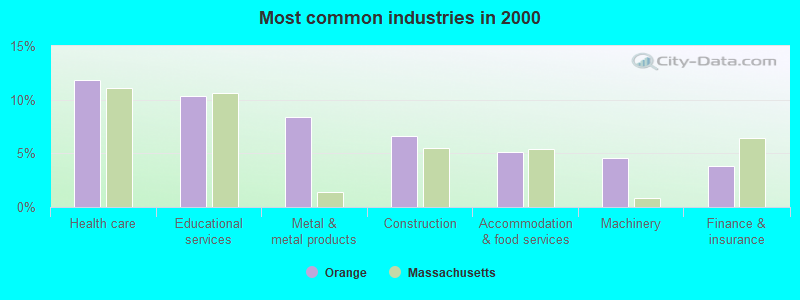
- Health care (11.8%)
- Educational services (10.3%)
- Metal & metal products (8.4%)
- Construction (6.6%)
- Accommodation & food services (5.1%)
- Machinery (4.6%)
- Finance & insurance (3.8%)

- Metal & metal products (13.1%)
- Construction (12.1%)
- Educational services (7.1%)
- Machinery (5.4%)
- Miscellaneous manufacturing (3.6%)
- Groceries & related products merchant wholesalers (3.6%)
- Plastics & rubber products (3.5%)
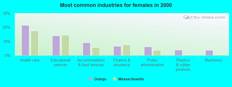
- Health care (21.4%)
- Educational services (14.0%)
- Accommodation & food services (9.2%)
- Finance & insurance (6.5%)
- Public administration (6.2%)
- Plastics & rubber products (4.0%)
- Machinery (3.7%)

- Other production occupations, including supervisors (11.5%)
- Metal workers and plastic workers (9.1%)
- Other management occupations, except farmers and farm managers (6.0%)
- Building and grounds cleaning and maintenance occupations (4.5%)
- Supervisors and other personal care and service workers, except child care workers (3.5%)
- Other office and administrative support workers, including supervisors (3.5%)
- Laborers and material movers, hand (3.4%)
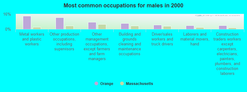
- Metal workers and plastic workers (14.0%)
- Other production occupations, including supervisors (12.4%)
- Other management occupations, except farmers and farm managers (7.6%)
- Building and grounds cleaning and maintenance occupations (6.1%)
- Driver/sales workers and truck drivers (4.5%)
- Laborers and material movers, hand (4.0%)
- Construction traders workers except carpenters, electricians, painters, plumbers, and construction laborers (3.8%)
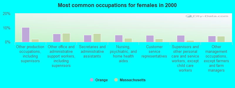
- Other production occupations, including supervisors (10.4%)
- Other office and administrative support workers, including supervisors (5.8%)
- Secretaries and administrative assistants (4.9%)
- Nursing, psychiatric, and home health aides (4.9%)
- Customer service representatives (4.8%)
- Supervisors and other personal care and service workers, except child care workers (4.8%)
- Other management occupations, except farmers and farm managers (4.3%)
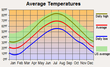
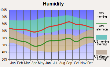
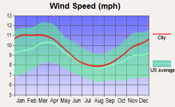
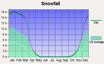
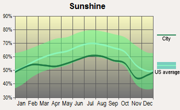
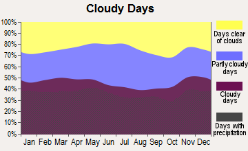
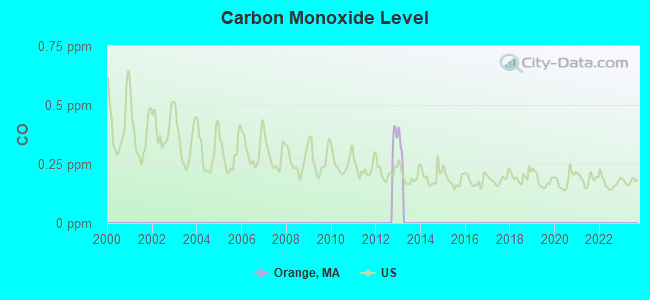
Average climate in Orange, Massachusetts
Based on data reported by over 4,000 weather stations
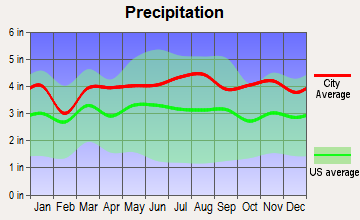
(lower is better)
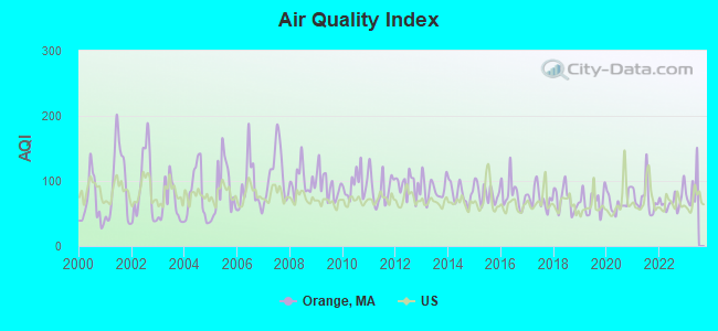
Air Quality Index (AQI) level in 2022 was 69.2. This is about average.
| City: | 69.2 |
| U.S.: | 72.6 |

Sulfur Dioxide (SO2) [ppb] level in 2022 was 0.216. This is significantly better than average. Closest monitor was 3.8 miles away from the city center.
| City: | 0.216 |
| U.S.: | 1.515 |
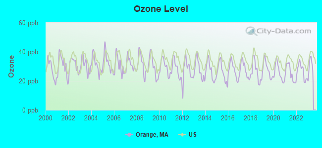
Ozone [ppb] level in 2022 was 26.4. This is better than average. Closest monitor was 11.3 miles away from the city center.
| City: | 26.4 |
| U.S.: | 33.3 |
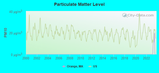
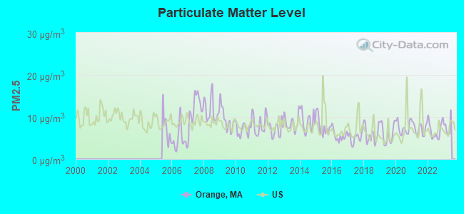
Particulate Matter (PM2.5) [µg/m3] level in 2022 was 6.85. This is about average. Closest monitor was 14.7 miles away from the city center.
| City: | 6.85 |
| U.S.: | 8.11 |
Tornado activity:
Orange-area historical tornado activity is above Massachusetts state average. It is 12% smaller than the overall U.S. average.
On 6/9/1953, a category F4 (max. wind speeds 207-260 mph) tornado 10.8 miles away from the Orange place center killed 90 people and injured 1228 people and caused between $50,000,000 and $500,000,000 in damages.
On 6/22/1981, a category F3 (max. wind speeds 158-206 mph) tornado 15.4 miles away from the place center injured 3 people and caused between $5000 and $50,000 in damages.
Earthquake activity:
Orange-area historical earthquake activity is significantly above Massachusetts state average. It is 70% smaller than the overall U.S. average.On 10/7/1983 at 10:18:46, a magnitude 5.3 (5.1 MB, 5.3 LG, 5.1 ML, Class: Moderate, Intensity: VI - VII) earthquake occurred 139.3 miles away from Orange center
On 4/20/2002 at 10:50:47, a magnitude 5.3 (5.3 ML, Depth: 3.0 mi) earthquake occurred 150.2 miles away from Orange center
On 4/20/2002 at 10:50:47, a magnitude 5.2 (5.2 MB, 4.2 MS, 5.2 MW, 5.0 MW) earthquake occurred 149.2 miles away from the city center
On 1/19/1982 at 00:14:42, a magnitude 4.7 (4.5 MB, 4.7 MD, 4.5 LG, Class: Light, Intensity: IV - V) earthquake occurred 72.5 miles away from the city center
On 10/16/2012 at 23:12:25, a magnitude 4.7 (4.7 ML, Depth: 10.0 mi) earthquake occurred 108.8 miles away from Orange center
On 10/2/1994 at 11:27:22, a magnitude 3.7 (3.5 LG, 3.7 LG, Depth: 6.2 mi, Class: Light, Intensity: II - III) earthquake occurred 16.7 miles away from the city center
Magnitude types: regional Lg-wave magnitude (LG), body-wave magnitude (MB), duration magnitude (MD), local magnitude (ML), surface-wave magnitude (MS), moment magnitude (MW)
Natural disasters:
The number of natural disasters in Franklin County (20) is greater than the US average (15).Major Disasters (Presidential) Declared: 9
Emergencies Declared: 10
Causes of natural disasters: Floods: 5, Storms: 5, Hurricanes: 4, Snowstorms: 4, Winter Storms: 3, Blizzards: 2, Snows: 2, Snowfall: 1, Tropical Storm: 1, Wind: 1, Other: 1 (Note: some incidents may be assigned to more than one category).
Hospitals and medical centers near Orange:
- QUABBIN VALLEY HEALTHCARE (Nursing Home, about 3 miles away; ATHOL, MA)
- ATHOL MEMORIAL HOME HEALTH AND HOSPICE (Hospital, about 4 miles away; ATHOL, MA)
- ATHOL MEMORIAL HOSPITAL Critical Access Hospitals (about 6 miles away; ATHOL, MA)
- TEMPLETON DEVELOPMENTAL CENTER (Hospital, about 10 miles away; BALDWINVILLE, MA)
- BALDWINVILLE NURSING HOME (Nursing Home, about 13 miles away; BALDWINVILLE, MA)
- APPLEWOOD CARE AND REHABILITATION CENTER (Nursing Home, about 13 miles away; WINCHESTER, NH)
- OPEN ARMS NURSING HOME INC (Nursing Home, about 14 miles away; WINCHENDON, MA)
Airports located in Orange:
- Orange Municipal Airport (ORE) (Runways: 2, Air Taxi Ops: 10,000, Itinerant Ops: 15,000, Local Ops: 8,000, Military Ops: 25)
Operable nuclear power plant near Orange:
- 17 miles: Vermont Yankee in Vernon, VT.
Colleges/universities with over 2000 students nearest to Orange:
- Mount Wachusett Community College (about 17 miles; Gardner, MA; Full-time enrollment: 3,143)
- University of Massachusetts-Amherst (about 18 miles; Amherst, MA; FT enrollment: 26,583)
- Franklin Pierce University (about 19 miles; Rindge, NH; FT enrollment: 2,139)
- Keene State College (about 24 miles; Keene, NH; FT enrollment: 5,098)
- Smith College (about 26 miles; Northampton, MA; FT enrollment: 3,549)
- Fitchburg State University (about 27 miles; Fitchburg, MA; FT enrollment: 5,010)
- Mount Holyoke College (about 27 miles; South Hadley, MA; FT enrollment: 2,573)
Public high school in Orange:
- RALPH C MAHAR REGIONAL (Students: 747, Location: 507 SOUTH MAIN STREET, Grades: 7-12)
Public elementary/middle schools in Orange:
- FISHER HILL (Students: 296, Location: 59 DEXTER STREET, Grades: PK-2)
- DEXTER PARK (Students: 282, Location: 3 DEXTER ST EXT, Grades: 3-6)
Points of interest:
Notable locations in Orange: Orange Fire Department Station 1 Headquarters (A), Ralph C Mahar Regional High School Library (B), Orange Town Hall (C), Wheeler Memorial Library (D). Display/hide their locations on the map
Churches in Orange include: Universalist Church (A), Saint Marys Parish Church (B), First Assembly of God Church (C), Central Congregational Church (D), Bethany Evangelical Lutheran Church (E). Display/hide their locations on the map
Reservoirs and swamps: Millers River Reservoir (A), Fall Hill Meadow (B). Display/hide their locations on the map
Streams, rivers, and creeks: Fall Hill Brook (A), Gulf Brook (B), Red Brook (C). Display/hide their locations on the map
Park in Orange: Orange Center Historic District (1). Display/hide its location on the map
Hotels: Bald Eagle Motel & Conference Center (110 Daniel Shays Highway), Executive Inn (110 Daniel Shays Highway).
Birthplace of: Myrtle Bachelder - Chemist, Denise Andrews - Politician, Robert Dexter Conrad - Navy officer, Whitey Witt - Baseball player.
Drinking water stations with addresses in Orange and their reported violations in the past:
ORANGE WATER DEPT (Population served: 6,487, Purch surface water):Past health violations:
- MCL, Monthly (TCR) - In NOV-2013, Contaminant: Coliform
- MCL, Monthly (TCR) - In JUN-2013, Contaminant: Coliform. Follow-up actions: St AO (w/o penalty) issued (JUL-26-2013)
| This place: | 2.6 people |
| Massachusetts: | 2.5 people |
| This place: | 67.7% |
| Whole state: | 63.0% |
| This place: | 11.1% |
| Whole state: | 7.0% |
Likely homosexual households (counted as self-reported same-sex unmarried-partner households)
- Lesbian couples: 0.8% of all households
- Gay men: 0.3% of all households
People in group quarters in Orange in 2010:
- 16 people in residential treatment centers for adults
- 10 people in workers' group living quarters and job corps centers
- 4 people in group homes intended for adults
Banks with branches in Orange (2011 data):
- Bank of America, National Association: Orange Branch at 85 East Main Street, branch established on 1967/12/18. Info updated 2009/11/18: Bank assets: $1,451,969.3 mil, Deposits: $1,077,176.8 mil, headquarters in Charlotte, NC, positive income, 5782 total offices, Holding Company: Bank Of America Corporation
- TD Bank, National Association: 30 East Main Street Branch at 30 East Main Street, branch established on 1871/01/01. Info updated 2010/10/04: Bank assets: $188,912.6 mil, Deposits: $153,149.8 mil, headquarters in Wilmington, DE, positive income, 1314 total offices, Holding Company: Toronto-Dominion Bank, The
For population 15 years and over in Orange:
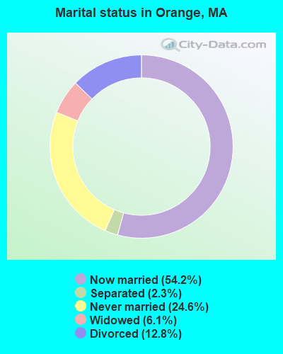
- Never married: 24.6%
- Now married: 54.2%
- Separated: 2.3%
- Widowed: 6.1%
- Divorced: 12.8%
For population 25 years and over in Orange:
- High school or higher: 93.9%
- Bachelor's degree or higher: 16.3%
- Graduate or professional degree: 6.8%
- Unemployed: 5.6%
- Mean travel time to work (commute): 27.1 minutes
| Here: | 8.4 |
| Massachusetts average: | 13.0 |


Graphs represent county-level data. Detailed 2008 Election Results
Religion statistics for Orange, MA (based on Franklin County data)


| Religion | Adherents | Congregations |
|---|---|---|
| Catholic | 16,509 | 15 |
| Mainline Protestant | 4,617 | 38 |
| Evangelical Protestant | 2,079 | 20 |
| Other | 1,580 | 21 |
| None | 46,587 | - |
Food Environment Statistics:
| Franklin County: | 3.63 / 10,000 pop. |
| Massachusetts: | 1.98 / 10,000 pop. |
| Franklin County: | 0.14 / 10,000 pop. |
| Massachusetts: | 0.05 / 10,000 pop. |
| Here: | 1.67 / 10,000 pop. |
| Massachusetts: | 2.22 / 10,000 pop. |
| This county: | 3.21 / 10,000 pop. |
| State: | 1.77 / 10,000 pop. |
| Franklin County: | 8.10 / 10,000 pop. |
| State: | 8.76 / 10,000 pop. |
| Franklin County: | 7.5% |
| State: | 8.1% |
| Franklin County: | 22.2% |
| Massachusetts: | 22.5% |
| Here: | 15.1% |
| State: | 16.5% |
Health and Nutrition:
| Here: | 52.4% |
| Massachusetts: | 50.5% |
| Here: | 50.9% |
| State: | 48.0% |
| This city: | 28.9 |
| Massachusetts: | 28.4 |
| Orange: | 21.3% |
| State: | 20.7% |
| This city: | 10.4% |
| State: | 10.4% |
| Orange: | 6.8 |
| State: | 6.8 |
| This city: | 36.7% |
| Massachusetts: | 33.4% |
| Orange: | 58.7% |
| Massachusetts: | 57.1% |
| This city: | 78.8% |
| State: | 79.2% |
More about Health and Nutrition of Orange, MA Residents
| Businesses in Orange, MA | ||||
| Name | Count | Name | Count | |
|---|---|---|---|---|
| Ace Hardware | 1 | Subway | 1 | |
| Decora Cabinetry | 2 | U-Haul | 1 | |
| Dunkin Donuts | 1 | UPS | 1 | |
| MasterBrand Cabinets | 2 | Walmart | 1 | |
Strongest AM radio stations in Orange:
- WCAT (700 AM; daytime; 2 kW; ORANGE-ATHOL, MA; Owner: CITADEL BROADCASTING COMPANY)
- WCRN (830 AM; 50 kW; WORCESTER, MA; Owner: CARTER BROADCASTING CORPORATION)
- WNNZ (640 AM; 50 kW; WESTFIELD, MA; Owner: CLEAR CHANNEL BROADCASTING LICENSES, INC.)
- WVNE (760 AM; daytime; 25 kW; LEICESTER, MA; Owner: BLOUNT MASSCOM, INC.)
- WIZZ (1520 AM; daytime; 10 kW; GREENFIELD, MA; Owner: P. & M. RADIO, LLC)
- WRKO (680 AM; 50 kW; BOSTON, MA; Owner: ENTERCOM BOSTON LICENSE, LLC)
- WEEI (850 AM; 50 kW; BOSTON, MA; Owner: ENTERCOM BOSTON LICENSE, LLC)
- WKOX (1200 AM; 50 kW; FRAMINGHAM, MA; Owner: CAPSTAR TX LIMITED PARTNERSHIP)
- WBIX (1060 AM; 40 kW; NATICK, MA; Owner: LANGER BROADCASTING CORPORATION)
- WALE (990 AM; 50 kW; GREENVILLE, RI; Owner: NORTH AMERICAN BROADCASTING CO., INC.)
- WTIC (1080 AM; 50 kW; HARTFORD, CT; Owner: INFINITY RADIO OPERATIONS INC.)
- WAMG (890 AM; 25 kW; DEDHAM, MA; Owner: MEGA COMMUNICATIONS OF DEDHAM LICENSEE, LLC)
- WPNI (1430 AM; 5 kW; AMHERST, MA; Owner: WESTERN MASSACHUSETTS RADIO COMPANY)
Strongest FM radio stations in Orange:
- WJDF (97.3 FM; ORANGE, MA; Owner: DEANE BROTHERS BROADCASTING CORP.)
- WAHL (99.9 FM; ATHOL, MA; Owner: CITADEL BROADCASTING COMPANY)
- WFCR (88.5 FM; AMHERST, MA; Owner: UNIVERSITY OF MASSACHUSETTS)
- WYRY (104.9 FM; HINSDALE, NH; Owner: TRI-VALLEY BROADCASTING CORPORATION)
- WPVQ (95.3 FM; GREENFIELD, MA; Owner: GREAT NORTHERN RADIO, L.L.C.)
- WAMH (89.3 FM; AMHERST, MA; Owner: TRUSTEES OF AMHERST COLLEGE)
- WFEX (92.1 FM; PETERBOROUGH, NH; Owner: FNX BROADCASTING OF NEW HAMPSHIRE LLC)
- WOQL (98.7 FM; WINCHESTER, NH; Owner: SAGA COMMUNICATIONS OF NEW HAMPSHIRE, LLC)
- WAMC-FM (90.3 FM; ALBANY, NY; Owner: WAMC)
- WAAF (107.3 FM; WORCESTER, MA; Owner: ENTERCOM BOSTON LICENSE, LLC)
- WHAI (98.3 FM; GREENFIELD, MA; Owner: SAGA COMMUNICATIONS OF NEW ENGLAND, LLC)
- W246AM (97.1 FM; AMHERST, MA; Owner: GREAT NORTHERN RADIO, LLC)
- WEQX (102.7 FM; MANCHESTER, VT; Owner: NORTHSHIRE COMMUNICATIONS, INC.)
- WINQ (97.7 FM; WINCHENDON, MA; Owner: SAGA COMMUNICATIONS OF NEW ENGLAND, LLC)
- WHYN-FM (93.1 FM; SPRINGFIELD, MA; Owner: CLEAR CHANNEL BROADCASTING LICENSES, INC.)
- WJAN (95.1 FM; SUNDERLAND, VT; Owner: 6 JOHNSON ROAD LICENSES, INC.)
- WVAY (100.7 FM; WILMINGTON, VT; Owner: GREAT NORTHERN RADIO, L.L.C.)
- WHDQ (106.1 FM; CLAREMONT, NH; Owner: GREAT NORTHERN RADIO, L.L.C.)
- WKNE (103.7 FM; KEENE, NH; Owner: SAGA COMMUNICATIONS OF NEW ENGLAND, LLC)
- WSRS (96.1 FM; WORCESTER, MA; Owner: CAPSTAR TX LIMITED PARTNERSHIP)
TV broadcast stations around Orange:
- WYDN (Channel 48; WORCESTER, MA; Owner: EDUCATIONAL PUBLIC TV CORPORATION)
- WUNI (Channel 27; WORCESTER, MA; Owner: ENTRAVISION HOLDINGS, LLC)
- WUTF (Channel 66; MARLBOROUGH, MA; Owner: TELEFUTURA BOSTON LLC)

- National Bridge Inventory (NBI) Statistics
- 13Number of bridges
- 194ft / 59.2mTotal length
- $39,311,000Total costs
- 79,607Total average daily traffic
- 7,408Total average daily truck traffic
- 89,433Total future (year 2031) average daily traffic
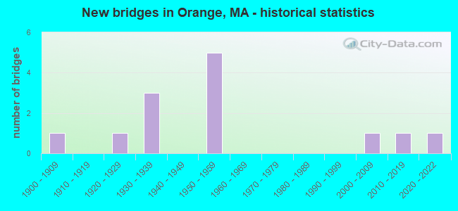
- New bridges - historical statistics
- 11900-1909
- 11920-1929
- 31930-1939
- 51950-1959
- 12000-2009
- 12010-2019
- 12020-2022
FCC Registered Cell Phone Towers:
1 (See the full list of FCC Registered Cell Phone Towers in Orange)FCC Registered Antenna Towers:
32 (See the full list of FCC Registered Antenna Towers)FCC Registered Broadcast Land Mobile Towers:
5- 18 Water St (Lat: 42.566750 Lon: -72.291194), Call Sign: KCE563,
Assigned Frequencies: 33.7800 MHz, 33.4800 MHz, 33.5400 MHz, 33.7000 MHz, 458.100 MHz, 33.0200 MHz, Grant Date: 03/12/2011, Expiration Date: 03/18/2021, Cancellation Date: 05/22/2021, Registrant: Skylines Unlimited Inc, 100 Stone Church Road, Carlisle, PA 17013, Phone: (717) 218-5003, Fax: (717) 218-5005, Email:
- Lat: 42.573389 Lon: -72.305833, Call Sign: WQQF620,
Assigned Frequencies: 457.087 MHz, 457.162 MHz, 457.712 MHz, 457.762 MHz, 457.862 MHz, Grant Date: 01/11/2023, Expiration Date: 11/28/2032, Certifier: Michael R Baldassarre, Registrant: Business Radio Licensing, 30251 Golden Lantern, Suite E #501, Laguna Niguel, CA 92677, Phone: (949) 348-8510, Fax: (949) 348-8514, Email:
- EAST RIVER ST TOWER, Off North Main Street (Lat: 42.606250 Lon: -72.301389), Type: Gtower, Structure height: 48.7 m, Call Sign: WQTS968,
Assigned Frequencies: 453.437 MHz, Grant Date: 04/07/2014, Expiration Date: 04/07/2024, Certifier: Craig Lundgren, Registrant: Fcc Forms, Springfield, OR 97477, Phone: (855) 345-3322, Fax: (855) 345-3322, Email:
- Lat: 42.564139 Lon: -72.285306, Call Sign: WRAT298,
Assigned Frequencies: 451.237 MHz, 451.237 MHz, 456.237 MHz, 456.237 MHz, 451.537 MHz, 451.537 MHz, 456.537 MHz, 456.537 MHz, Grant Date: 02/22/2018, Expiration Date: 02/22/2028, Certifier: Roy A Howard, Registrant: Skylines Unlimited Inc., 100 Stone Church Road, Carlisle, PA 17015, Phone: (717) 218-5003, Fax: (844) 727-2070, Email:
- Lat: 42.574722 Lon: -72.302500, Call Sign: WRVW419,
Assigned Frequencies: 451.412 MHz, 452.137 MHz, 452.787 MHz, 456.412 MHz, 457.137 MHz, Grant Date: 01/13/2023, Expiration Date: 01/13/2033, Certifier: Ian Spencer, Registrant: Comtronics Corporation, 1230 Furnace Brook Pkwy., Quincy, MA 02169, Phone: (617) 770-0212, Fax: (617) 770-0429, Email:
FCC Registered Paging Towers:
2- 660 East Main St. (Lat: 42.585083 Lon: -72.281750), Call Sign: KNKD581,
Assigned Frequencies: 43.4200 MHz, Expiration Date: 04/01/1999, Cancellation Date: 03/31/1999, Registrant: Mobilemedia Communications, Inc., Debtor-In-Possession, 2101 Wilson Boulevard, Suite 935, Arlington, VA 22201, Phone: (703) 312-5153, Fax: (703) 312-5155, Email:
- Lake Mattawa & Walnut Hill Roads (Lat: 42.580917 Lon: -72.320083), Call Sign: KNLW496,
Assigned Frequencies: 152.060 MHz, Grant Date: 12/27/2017, Expiration Date: 11/14/2027, Certifier: Robert Armstrong, Registrant: New Hampshire Electric Cooperative, Inc., 579 Tenney Mountain Hwy, Plymouth, NH 03264, Phone: (603) 536-8811, Email:
FCC Registered Maritime Coast & Aviation Ground Towers:
2- Orange Municipal Airport (Lat: 42.568972 Lon: -72.287861), Overall height: 3 m, Call Sign: WDO5, Licensee ID: L00005309,
Assigned Frequencies: 122.800 MHz, Grant Date: 11/06/1997, Expiration Date: 11/27/2002, Cancellation Date: 03/02/2003, Registrant: Orange Airport Commission, 80 Airport St, Orange, MA 01364
- Orange Municipal Airport (Lat: 42.568972 Lon: -72.287861), Type: Building, Structure height: 164 m, Overall height: 170 m, Call Sign: WQDY343,
Assigned Frequencies: 122.800 MHz, Grant Date: 11/29/2005, Expiration Date: 11/29/2015, Cancellation Date: 01/30/2016, Certifier: Len Bedaw, Registrant: 80 Airport St., Orange, MA 01364, Phone: (978) 544-8189, Fax: (978) 544-1126, Email:
FCC Registered Amateur Radio Licenses:
45 (See the full list of FCC Registered Amateur Radio Licenses in Orange)FAA Registered Aircraft Manufacturers and Dealers:
1 (See the full list of FAA Registered Manufacturers and Dealers in Orange)FAA Registered Aircraft:
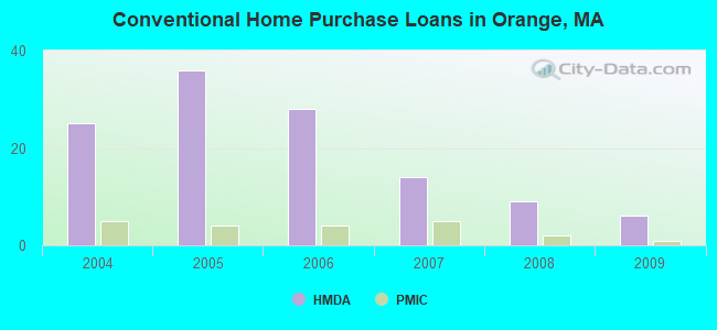
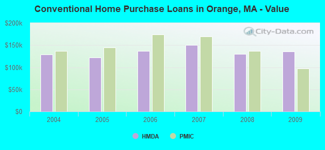
7 (See the full list of FAA Registered Aircraft)| Home Mortgage Disclosure Act Aggregated Statistics For Year 2009 (Based on 1 partial tract) | ||||||||||||||
| A) FHA, FSA/RHS & VA Home Purchase Loans | B) Conventional Home Purchase Loans | C) Refinancings | D) Home Improvement Loans | E) Loans on Dwellings For 5+ Families | F) Non-occupant Loans on < 5 Family Dwellings (A B C & D) | G) Loans On Manufactured Home Dwelling (A B C & D) | ||||||||
|---|---|---|---|---|---|---|---|---|---|---|---|---|---|---|
| Number | Average Value | Number | Average Value | Number | Average Value | Number | Average Value | Number | Average Value | Number | Average Value | Number | Average Value | |
| LOANS ORIGINATED | 4 | $149,912 | 6 | $135,955 | 17 | $131,330 | 5 | $47,804 | 1 | $68,340 | 2 | $98,995 | 0 | $0 |
| APPLICATIONS APPROVED, NOT ACCEPTED | 0 | $0 | 0 | $0 | 2 | $118,340 | 0 | $0 | 0 | $0 | 0 | $0 | 0 | $0 |
| APPLICATIONS DENIED | 1 | $71,860 | 2 | $115,825 | 10 | $158,757 | 2 | $37,855 | 0 | $0 | 1 | $83,420 | 1 | $33,160 |
| APPLICATIONS WITHDRAWN | 0 | $0 | 1 | $126,460 | 7 | $147,544 | 0 | $0 | 0 | $0 | 1 | $91,960 | 0 | $0 |
| FILES CLOSED FOR INCOMPLETENESS | 0 | $0 | 0 | $0 | 2 | $112,225 | 0 | $0 | 0 | $0 | 0 | $0 | 0 | $0 |
Detailed HMDA statistics for the following Tracts: 0405.00
| Private Mortgage Insurance Companies Aggregated Statistics For Year 2009 (Based on 1 partial tract) | ||||
| A) Conventional Home Purchase Loans | B) Refinancings | |||
|---|---|---|---|---|
| Number | Average Value | Number | Average Value | |
| LOANS ORIGINATED | 1 | $97,650 | 0 | $0 |
| APPLICATIONS APPROVED, NOT ACCEPTED | 1 | $91,620 | 1 | $83,920 |
| APPLICATIONS DENIED | 1 | $117,750 | 1 | $85,430 |
| APPLICATIONS WITHDRAWN | 0 | $0 | 1 | $89,450 |
| FILES CLOSED FOR INCOMPLETENESS | 0 | $0 | 0 | $0 |
Detailed PMIC statistics for the following Tracts: 0405.00
2002 - 2018 National Fire Incident Reporting System (NFIRS) incidents
- Fire incident types reported to NFIRS in Orange, MA
- 40454.7%Structure Fires
- 22129.9%Outside Fires
- 608.1%Mobile Property/Vehicle Fires
- 537.2%Other
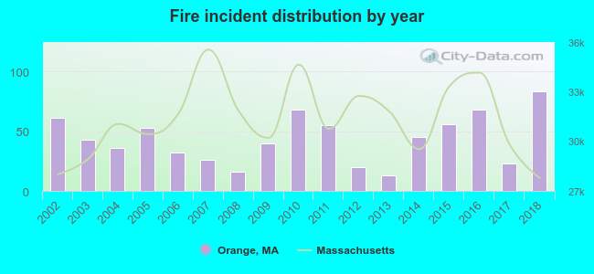 According to the data from the years 2002 - 2018 the average number of fires per year is 43. The highest number of reported fires - 83 took place in 2018, and the least - 13 in 2013. The data has a growing trend.
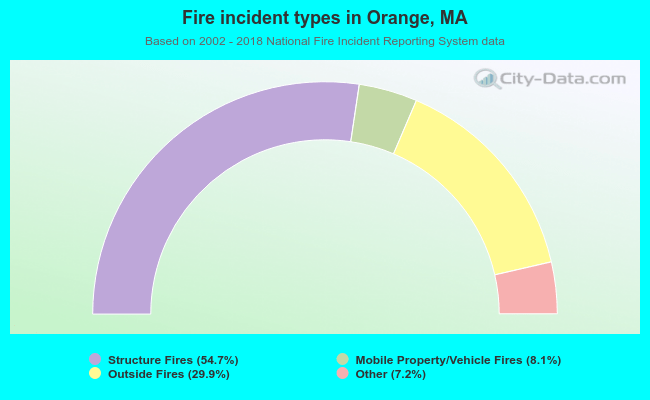 When looking into fire subcategories, the most incidents belonged to: Structure Fires (54.7%), and Outside Fires (29.9%).
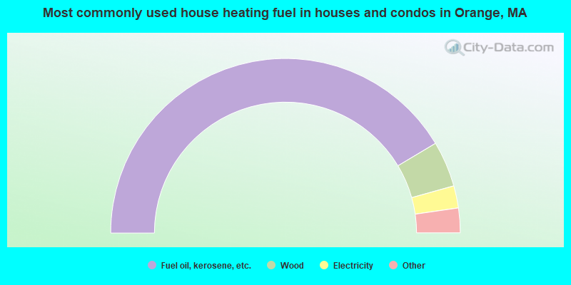
- 83.1%Fuel oil, kerosene, etc.
- 8.5%Wood
- 4.1%Electricity
- 2.3%Utility gas
- 2.1%Bottled, tank, or LP gas

- 61.3%Fuel oil, kerosene, etc.
- 29.5%Electricity
- 9.2%Wood
Orange compared to Massachusetts state average:
- Median household income below state average.
- Median house value significantly below state average.
- Unemployed percentage below state average.
- Black race population percentage significantly below state average.
- Hispanic race population percentage below state average.
- Foreign-born population percentage significantly below state average.
- Length of stay since moving in above state average.
- Number of college students below state average.
- Percentage of population with a bachelor's degree or higher below state average.

|
Total of 7 patent applications in 2008-2024.