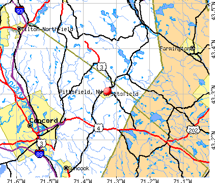
Pittsfield, New Hampshire
Pittsfield: Pittsfield NH
Pittsfield: Falls in Pittsfield NH
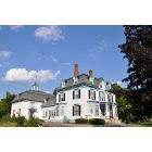
Pittsfield: Tuttle Mansion, built by Gov. of NH
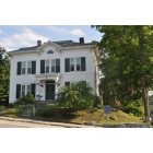
Pittsfield: historic homes of Pittsfield
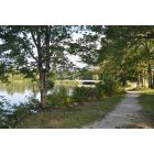
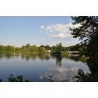
Pittsfield: Walking trails around the lake in Pittsfield NH
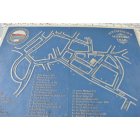
Pittsfield: Take a historic walking tour of Pittsfield NH. Map with locations of historic markers.
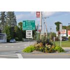
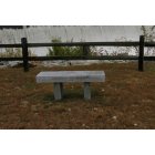
Pittsfield: I love how landscaped the public areas are in Pittsfield NH
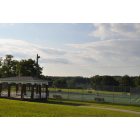
Pittsfield: Pittsfield athletic park, tennis courts, playground, lake, walking trails, baseball diamonds, soccer fields, basketball court.
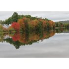
Pittsfield: Suncook River, Pittsfield NH
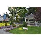
Pittsfield: Frank Lyman Park, Historical walking tour map.
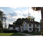
Pittsfield: historic homes of Pittsfield
- see
34
more - add
your


Submit your own pictures of this place and show them to the world
- OSM Map
- General Map
- Google Map
- MSN Map
Population change since 2000: -5.6%
| Males: 740 | |
| Females: 836 |
| Median resident age: | 54.6 years |
| New Hampshire median age: | 43.3 years |
Zip codes: 03263.
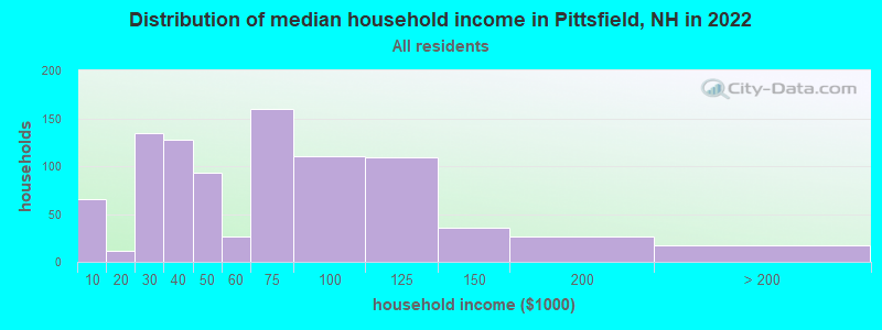
| Pittsfield: | $44,015 |
| NH: | $89,992 |
Estimated per capita income in 2022: $34,434 (it was $17,845 in 2000)
Pittsfield CDP income, earnings, and wages data
Estimated median house or condo value in 2022: $232,629 (it was $84,700 in 2000)
| Pittsfield: | $232,629 |
| NH: | $384,700 |
Mean prices in 2022: all housing units: $378,901; detached houses: $416,256; townhouses or other attached units: $317,750; in 2-unit structures: $298,869; in 3-to-4-unit structures: $371,619; in 5-or-more-unit structures: $216,601; mobile homes: $110,180; occupied boats, rvs, vans, etc.: $74,347
Median gross rent in 2022: $1,038.
Detailed information about poverty and poor residents in Pittsfield, NH
Compare current foreclosures near Pittsfield, NH:
| Photo | Address | Area | Beds / Baths | Price | Details |
|---|---|---|---|---|---|

|
#1
Fairview Road Aka 42 Fairview Drive
Pittsfield, NH Array
|
2,078 sq. feet
|
2 baths 3 beds |
show details | |

|
#2
Dowboro Rd
Pittsfield, NH 03263
|
- sq. feet
|
- baths - beds |
show details | |

|
#3
Fairview Dr
Pittsfield, NH 03263
|
- sq. feet
|
- baths - beds |
show details | |

|
#4
Hilltop Dr
Pittsfield, NH 03263
|
- sq. feet
|
- baths - beds |
show details | |

|
#5
Tilton Hill Rd
Pittsfield, NH 03263
|
- sq. feet
|
- baths - beds |
show details | |

|
#6
Fisherville Rd Unit 21
Concord, NH 03303
|
990 sq. feet
|
1 baths 2 beds |
show details | |

|
#7
Portsmouth St
Concord, NH 03301
|
1,184 sq. feet
|
2 baths 3 beds |
show details | |

|
#8
Old Turnpike Rd
Nottingham, NH 03290
|
4,738 sq. feet
|
3 baths 3 beds |
show details | |

|
#9
Tasker Hill Rd
Strafford, NH 03884
|
2,630 sq. feet
|
3 baths 3 beds |
show details | |

|
#10
Mcdaniel Shore Dr
Barrington, NH 03825
|
2,681 sq. feet
|
1 baths 3 beds |
show details |
| Photo | Address | Area | Beds / Baths | Price | Details |
|---|---|---|---|---|---|

|
#11
Charles St
Farmington, NH 03835
|
1,066 sq. feet
|
1 baths 3 beds |
show details | |

|
#12
Frank C Gilman Hwy
Alton, NH 03809
|
1,712 sq. feet
|
1 baths 3 beds |
show details | |

|
#13
1st Crown Point Rd
Strafford, NH 03884
|
1,738 sq. feet
|
1 baths 3 beds |
show details | |

|
#14
Academy Rd
Suncook, NH 03275
|
1,428 sq. feet
|
1 baths 3 beds |
show details | |

|
#15
Roller Coaster Rd
Strafford, NH 03884
|
2,530 sq. feet
|
3 baths 6 beds |
show details | |

|
#16
N State St
Concord, NH 03301
|
6,861 sq. feet
|
7 baths 5 beds |
show details | |

|
#17
1st Nh Tpke
Northwood, NH 03261
|
3,778 sq. feet
|
2 baths 6 beds |
show details | |

|
#18
Richmond Dr
Concord, NH 03303
|
1,776 sq. feet
|
2 baths 3 beds |
show details | |

|
#19
Meaderboro Rd
Rochester, NH 03867
|
- sq. feet
|
2 baths 3 beds |
show details | |

|
#20
S Fruit St
Concord, NH 03301
|
1,768 sq. feet
|
2 baths 4 beds |
show details |
| Photo | Address | Area | Beds / Baths | Price | Details |
|---|---|---|---|---|---|

|
#21
Adams St
Laconia, NH 03246
|
1,956 sq. feet
|
1 baths 3 beds |
show details | |

|
#22
Province St
Laconia, NH 03246
|
818 sq. feet
|
1 baths 2 beds |
show details | |

|
#23
Denmark Dr
Northwood, NH 03261
|
1,809 sq. feet
|
2 baths 3 beds |
show details | |

|
#24
Abbott Rd
Concord, NH 03303
|
1,386 sq. feet
|
1 baths 2 beds |
show details | |

|
#25
Pinnacle St
Hooksett, NH 03106
|
2,238 sq. feet
|
2 baths 3 beds |
show details | |

|
#26
Thurston Pond Rd
Deerfield, NH 03037
|
- sq. feet
|
2 baths 3 beds |
show details | |

|
#27
Union Ave
Laconia, NH 03246
|
6,055 sq. feet
|
2 baths - beds |
show details | |

|
#28
Berry River Rd
Barrington, NH 03825
|
- sq. feet
|
- baths - beds |
show details | |

|
#29
Alice Dr Apt 108
Concord, NH 03303
|
- sq. feet
|
- baths - beds |
show details | |

|
#30
Clark St
Belmont, NH 03220
|
960 sq. feet
|
- baths - beds |
show details |
| Photo | Address | Area | Beds / Baths | Price | Details |
|---|---|---|---|---|---|

|
#31
Juniper Ln
Bow, NH 03304
|
- sq. feet
|
- baths - beds |
show details | |

|
#32
Cabernet Dr Unit 2
Concord, NH 03303
|
- sq. feet
|
- baths - beds |
show details | |

|
#33
School St
Suncook, NH 03275
|
- sq. feet
|
- baths - beds |
show details | |

|
#34
Landing Ln # 131
Laconia, NH 03246
|
- sq. feet
|
- baths - beds |
show details | |

|
#35
Wethersfield Dr
Tilton, NH 03276
|
- sq. feet
|
- baths - beds |
show details | |

|
#36
Marilyn Dr
Suncook, NH 03275
|
- sq. feet
|
- baths - beds |
show details | |

|
#37
Prospect St Apt 2
Tilton, NH 03276
|
- sq. feet
|
- baths - beds |
show details | |

|
#38
Canal St # 415
Suncook, NH 03275
|
- sq. feet
|
- baths - beds |
show details | |

|
#39
Horne Rd
Belmont, NH 03220
|
1,491 sq. feet
|
- baths - beds |
show details | |

|
#40
France Rd
Barrington, NH 03825
|
- sq. feet
|
- baths - beds |
show details |
| Photo | Address | Area | Beds / Baths | Price | Details |
|---|---|---|---|---|---|

|
#41
Corn Hill Rd
Concord, NH 03303
|
- sq. feet
|
- baths - beds |
show details | |

|
#42
Mcdaniel Shore Dr
Barrington, NH 03825
|
- sq. feet
|
- baths - beds |
show details | |

|
#43
Sand Hill Rd
Gilford, NH 03249
|
- sq. feet
|
- baths - beds |
show details | |

|
#44
Durkee St # B
Laconia, NH 03246
|
- sq. feet
|
- baths - beds |
show details | |

|
#45
Union Rd
Belmont, NH 03220
|
1,104 sq. feet
|
- baths - beds |
show details | |

|
#46
Bay Hill Rd # 1
Tilton, NH 03276
|
- sq. feet
|
- baths - beds |
show details | |

|
#47
Ferry St # 1
Suncook, NH 03275
|
- sq. feet
|
- baths - beds |
show details | |

|
#48
Academy St Apt 3
Laconia, NH 03246
|
- sq. feet
|
- baths - beds |
show details | |

|
#49
Karen Dr
Belmont, NH 03220
|
1,920 sq. feet
|
- baths - beds |
show details | |

|
Check over 1 million property listings on Foreclosure.com!
|
browse all offers | |||


- 1,75997.3%White alone
- 452.5%Two or more races
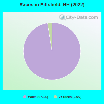
Races in Pittsfield detailed stats: ancestries, foreign born residents, place of birth
According to our research of New Hampshire and other state lists, there were 16 registered sex offenders living in Pittsfield, New Hampshire as of April 25, 2024.
The ratio of all residents to sex offenders in Pittsfield is 102 to 1.
Type |
2009 |
2010 |
2011 |
2012 |
2013 |
2014 |
2015 |
2016 |
2017 |
2018 |
2019 |
2020 |
2021 |
2022 |
|---|---|---|---|---|---|---|---|---|---|---|---|---|---|---|
| Murders (per 100,000) | 0 (0.0) | 0 (0.0) | 0 (0.0) | 0 (0.0) | 0 (0.0) | 0 (0.0) | 0 (0.0) | 0 (0.0) | 0 (0.0) | 0 (0.0) | 0 (0.0) | 0 (0.0) | 0 (0.0) | 0 (0.0) |
| Rapes (per 100,000) | 3 (68.0) | 1 (24.4) | 5 (121.6) | 1 (24.3) | 2 (48.9) | 3 (73.6) | 6 (147.7) | 1 (24.6) | 2 (48.9) | 0 (0.0) | 5 (120.7) | 2 (48.5) | 5 (120.6) | 5 (120.3) |
| Robberies (per 100,000) | 1 (22.7) | 1 (24.4) | 0 (0.0) | 1 (24.3) | 0 (0.0) | 1 (24.5) | 1 (24.6) | 0 (0.0) | 1 (24.5) | 0 (0.0) | 1 (24.1) | 0 (0.0) | 0 (0.0) | 0 (0.0) |
| Assaults (per 100,000) | 8 (181.4) | 3 (73.1) | 5 (121.6) | 7 (169.9) | 1 (24.4) | 6 (147.2) | 3 (73.9) | 9 (221.2) | 3 (73.4) | 7 (170.7) | 9 (217.3) | 7 (169.7) | 11 (265.3) | 9 (216.6) |
| Burglaries (per 100,000) | 12 (272.2) | 11 (267.9) | 28 (681.1) | 35 (849.7) | 6 (146.7) | 27 (662.3) | 17 (418.6) | 10 (245.8) | 8 (195.8) | 2 (48.8) | 3 (72.4) | 5 (121.2) | 1 (24.1) | 3 (72.2) |
| Thefts (per 100,000) | 52 (1,179) | 63 (1,534) | 90 (2,189) | 73 (1,772) | 13 (317.8) | 45 (1,104) | 23 (566.4) | 50 (1,229) | 19 (465.0) | 15 (365.8) | 16 (386.3) | 19 (460.5) | 20 (482.4) | 17 (409.1) |
| Auto thefts (per 100,000) | 1 (22.7) | 10 (243.5) | 6 (145.9) | 2 (48.6) | 0 (0.0) | 4 (98.1) | 2 (49.2) | 3 (73.7) | 2 (48.9) | 1 (24.4) | 2 (48.3) | 1 (24.2) | 4 (96.5) | 3 (72.2) |
| Arson (per 100,000) | 0 (0.0) | 0 (0.0) | 0 (0.0) | 0 (0.0) | 0 (0.0) | 1 (24.5) | 0 (0.0) | 2 (49.2) | 0 (0.0) | 0 (0.0) | 0 (0.0) | 2 (48.5) | 0 (0.0) | 0 (0.0) |
| City-Data.com crime index | 165.6 | 141.0 | 268.5 | 195.0 | 67.0 | 194.0 | 196.3 | 136.2 | 97.4 | 54.1 | 171.7 | 101.6 | 178.2 | 166.8 |
The City-Data.com crime index weighs serious crimes and violent crimes more heavily. Higher means more crime, U.S. average is 246.1. It adjusts for the number of visitors and daily workers commuting into cities.
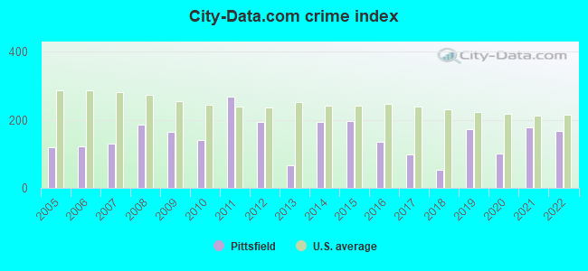
Crime rate in Pittsfield detailed stats: murders, rapes, robberies, assaults, burglaries, thefts, arson
Full-time law enforcement employees in 2021, including police officers: 7 (7 officers - 7 male; 0 female).
| Officers per 1,000 residents here: | 1.69 |
| New Hampshire average: | 2.14 |
 Recent articles from our blog. Our writers, many of them Ph.D. graduates or candidates, create easy-to-read articles on a wide variety of topics.


 | Pittsfield NH (7 replies) |
| Current Political vibe in New Hampshire (8 replies) |
| Can you recommend a place in NH for a 30 year old single man? (42 replies) |
| Thinking of moving to New Hampshire from WA (40 replies) |
| white mountains/Mt. Washington (13 replies) |
| Love everything about this state but... (130 replies) |
Latest news from Pittsfield, NH collected exclusively by city-data.com from local newspapers, TV, and radio stations
Ancestries: American (28.7%), Irish (24.7%), European (7.7%), Italian (6.6%), French (5.8%), English (5.3%).
Current Local Time: EST time zone
Incorporated in 1782
Elevation: 501 feet
Land area: 1.62 square miles.
Population density: 972 people per square mile (low).
36 residents are foreign born
| This place: | 2.0% |
| New Hampshire: | 6.0% |
Median real estate property taxes paid for housing units with mortgages in 2022: $5,167 (2.1%)
Median real estate property taxes paid for housing units with no mortgage in 2022: $4,173 (1.9%)
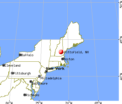
Nearest city with pop. 50,000+: Manchester, NH  (23.0 miles , pop. 107,006).
Nearest city with pop. 200,000+: Boston, MA (69.2 miles , pop. 589,141).
Nearest city with pop. 1,000,000+: Bronx, NY (214.5 miles , pop. 1,332,650).
Nearest cities:
), ), ), ), Latitude: 43.31 N, Longitude: 71.33 W
Area code: 603
Single-family new house construction building permits:
- 2022: 6 buildings, average cost: $249,800
- 2021: 6 buildings, average cost: $249,800
- 2020: 5 buildings, average cost: $249,800
- 2019: 4 buildings, average cost: $249,800
- 2018: 4 buildings, average cost: $249,800
- 2016: 2 buildings, average cost: $226,800
- 2015: 2 buildings, average cost: $226,800
- 2014: 1 building, cost: $211,200
- 2009: 1 building, cost: $178,900
- 2008: 2 buildings, average cost: $130,000
- 2007: 8 buildings, average cost: $121,900
- 2006: 7 buildings, average cost: $147,000
- 2005: 23 buildings, average cost: $152,200
- 2004: 30 buildings, average cost: $138,800
- 2003: 34 buildings, average cost: $130,700
- 2002: 32 buildings, average cost: $130,700
- 2001: 48 buildings, average cost: $121,400
- 2000: 36 buildings, average cost: $118,000
- 1999: 14 buildings, average cost: $109,200
- 1998: 15 buildings, average cost: $95,700
- 1997: 9 buildings, average cost: $91,700
| Here: | 2.2% |
| New Hampshire: | 2.5% |
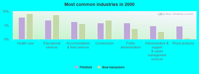
- Health care (7.9%)
- Educational services (6.8%)
- Accommodation & food services (6.3%)
- Construction (5.8%)
- Public administration (5.8%)
- Administrative & support & waste management services (4.8%)
- Wood products (4.7%)
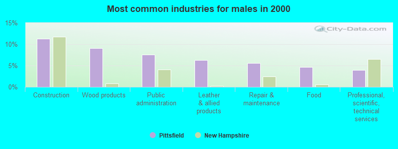
- Construction (11.3%)
- Wood products (9.1%)
- Public administration (7.6%)
- Leather & allied products (6.2%)
- Repair & maintenance (5.6%)
- Food (4.7%)
- Professional, scientific, technical services (4.0%)
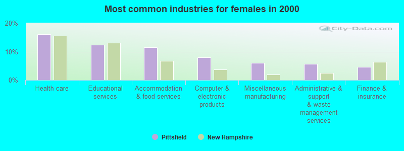
- Health care (16.2%)
- Educational services (12.4%)
- Accommodation & food services (11.5%)
- Computer & electronic products (8.0%)
- Miscellaneous manufacturing (6.1%)
- Administrative & support & waste management services (5.6%)
- Finance & insurance (4.7%)
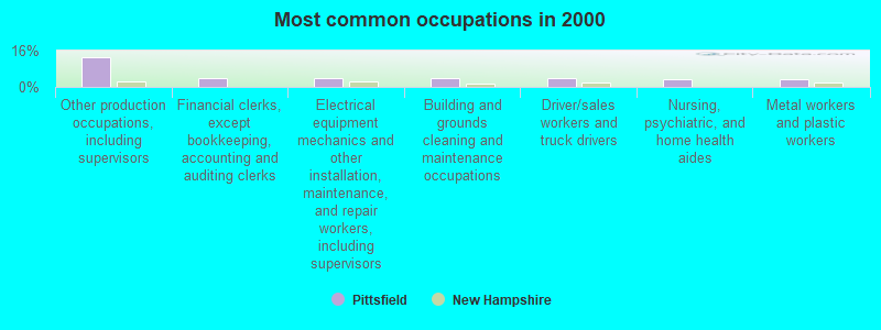
- Other production occupations, including supervisors (12.9%)
- Financial clerks, except bookkeeping, accounting and auditing clerks (4.1%)
- Electrical equipment mechanics and other installation, maintenance, and repair workers, including supervisors (3.9%)
- Building and grounds cleaning and maintenance occupations (3.8%)
- Driver/sales workers and truck drivers (3.6%)
- Nursing, psychiatric, and home health aides (3.5%)
- Metal workers and plastic workers (3.5%)
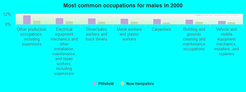
- Other production occupations, including supervisors (10.9%)
- Electrical equipment mechanics and other installation, maintenance, and repair workers, including supervisors (7.6%)
- Driver/sales workers and truck drivers (7.1%)
- Metal workers and plastic workers (6.9%)
- Carpenters (6.7%)
- Building and grounds cleaning and maintenance occupations (6.0%)
- Vehicle and mobile equipment mechanics, installers, and repairers (4.2%)
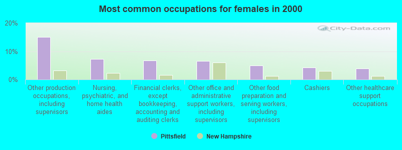
- Other production occupations, including supervisors (15.0%)
- Nursing, psychiatric, and home health aides (7.3%)
- Financial clerks, except bookkeeping, accounting and auditing clerks (6.8%)
- Other office and administrative support workers, including supervisors (6.6%)
- Other food preparation and serving workers, including supervisors (4.9%)
- Cashiers (4.2%)
- Other healthcare support occupations (4.0%)
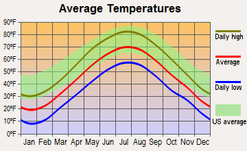
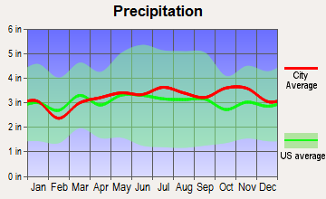
Average climate in Pittsfield, New Hampshire
Based on data reported by over 4,000 weather stations

|
|

(lower is better)

Air Quality Index (AQI) level in 2022 was 51.1. This is significantly better than average.
| City: | 51.1 |
| U.S.: | 72.6 |
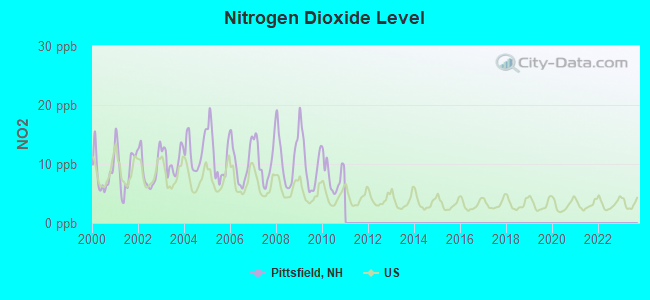
Nitrogen Dioxide (NO2) [ppb] level in 2010 was 8.02. This is significantly worse than average. Closest monitor was 13.5 miles away from the city center.
| City: | 8.02 |
| U.S.: | 5.11 |
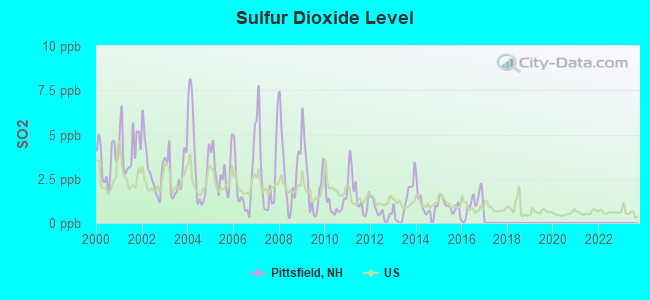
Sulfur Dioxide (SO2) [ppb] level in 2016 was 1.05. This is significantly better than average. Closest monitor was 11.2 miles away from the city center.
| City: | 1.05 |
| U.S.: | 1.51 |
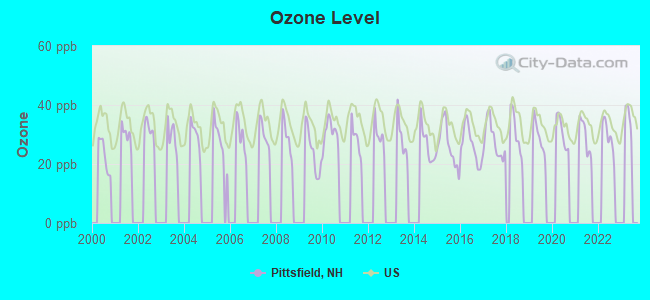
Ozone [ppb] level in 2022 was 29.4. This is about average. Closest monitor was 11.2 miles away from the city center.
| City: | 29.4 |
| U.S.: | 33.3 |
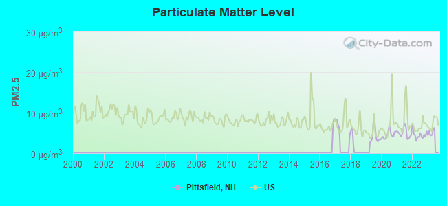
Particulate Matter (PM2.5) [µg/m3] level in 2022 was 4.52. This is significantly better than average. Closest monitor was 12.4 miles away from the city center.
| City: | 4.52 |
| U.S.: | 8.11 |
Tornado activity:
Pittsfield-area historical tornado activity is near New Hampshire state average. It is 52% smaller than the overall U.S. average.
On 6/9/1953, a category F3 (max. wind speeds 158-206 mph) tornado 29.4 miles away from the Pittsfield place center injured 5 people and caused between $5000 and $50,000 in damages.
On 7/6/1999, a category F2 (max. wind speeds 113-157 mph) tornado 0.5 miles away from the place center .
Earthquake activity:
Pittsfield-area historical earthquake activity is significantly above New Hampshire state average. It is 72% smaller than the overall U.S. average.On 4/20/2002 at 10:50:47, a magnitude 5.3 (5.3 ML, Depth: 3.0 mi, Class: Moderate, Intensity: VI - VII) earthquake occurred 144.6 miles away from Pittsfield center
On 1/19/1982 at 00:14:42, a magnitude 4.7 (4.5 MB, 4.7 MD, 4.5 LG, Class: Light, Intensity: IV - V) earthquake occurred 19.2 miles away from the city center
On 10/7/1983 at 10:18:46, a magnitude 5.3 (5.1 MB, 5.3 LG, 5.1 ML) earthquake occurred 157.4 miles away from the city center
On 4/20/2002 at 10:50:47, a magnitude 5.2 (5.2 MB, 4.2 MS, 5.2 MW, 5.0 MW) earthquake occurred 144.5 miles away from Pittsfield center
On 10/16/2012 at 23:12:25, a magnitude 4.7 (4.7 ML, Depth: 10.0 mi) earthquake occurred 39.3 miles away from Pittsfield center
On 8/21/1996 at 07:54:14, a magnitude 3.8 (3.8 LG, 3.6 LG, Depth: 6.2 mi, Class: Light, Intensity: II - III) earthquake occurred 60.7 miles away from the city center
Magnitude types: regional Lg-wave magnitude (LG), body-wave magnitude (MB), duration magnitude (MD), local magnitude (ML), surface-wave magnitude (MS), moment magnitude (MW)
Natural disasters:
The number of natural disasters in Merrimack County (27) is a lot greater than the US average (15).Major Disasters (Presidential) Declared: 17
Emergencies Declared: 9
Causes of natural disasters: Storms: 13, Floods: 12, Winter Storms: 4, Snowstorms: 3, Hurricanes: 2, Snows: 2, Blizzard: 1, Ice Storm: 1, Snowfall: 1, Tornado: 1, Tropical Storm: 1, Wind: 1, Other: 1 (Note: some incidents may be assigned to more than one category).
Hospitals and medical centers near Pittsfield:
- EPSOM HEALTHCARE CENTER (Nursing Home, about 5 miles away; EPSOM, NH)
- HAVENWOOD-HERITAGE HEIGHTS (Nursing Home, about 12 miles away; CONCORD, NH)
- HARRIS HILL CENTER, GENESIS HEALTHCARE (Nursing Home, about 14 miles away; CONCORD, NH)
- CONCORD REGIONAL VNA (Home Health Center, about 14 miles away; CONCORD, NH)
- NEW HAMPSHIRE HOSP-MED SURG BLDG (Hospital, about 14 miles away; CONCORD, NH)
- NEW HAMPSHIRE HOSP-PSYCH UNIT (Hospital, about 14 miles away; CONCORD, NH)
- N H HOSPITAL-PSYCHIATRIC NURSING HOME (Nursing Home, about 14 miles away; CONCORD, NH)
Colleges/universities with over 2000 students nearest to Pittsfield:
- NHTI-Concord's Community College (about 12 miles; Concord, NH; Full-time enrollment: 2,865)
- Southern New Hampshire University (about 20 miles; Manchester, NH; FT enrollment: 16,552)
- University of New Hampshire-Main Campus (about 24 miles; Durham, NH; FT enrollment: 15,243)
- Saint Anselm College (about 25 miles; Manchester, NH; FT enrollment: 2,059)
- Mount Washington College (about 25 miles; Manchester, NH; FT enrollment: 2,187)
- Plymouth State University (about 37 miles; Plymouth, NH; FT enrollment: 4,838)
- Northern Essex Community College (about 39 miles; Haverhill, MA; FT enrollment: 4,737)
Public high school in Pittsfield:
- PITTSFIELD HIGH SCHOOL (Students: 215, Location: 23 ONEIDA ST., Grades: 9-12)
Public elementary/middle schools in Pittsfield:
- PITTSFIELD ELEMENTARY SCHOOL (Students: 396, Location: 34 BOW ST., Grades: PK-6)
- PITTSFIELD MIDDLE SCHOOL (Students: 85, Location: 23 ONEIDA ST., Grades: 7-8)
Points of interest:
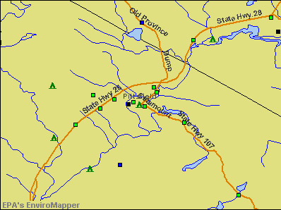
Notable locations in Pittsfield: Carpenter Memorial Library (A), Pittsfield Fire Department (B), Pittsfield Community Center (C). Display/hide their locations on the map
Churches in Pittsfield include: Pittsfield Church of God (A), Advent Christian Church (B). Display/hide their locations on the map
Cemetery: Floral Park Cemetery (1). Display/hide its location on the map
Streams, rivers, and creeks: Berry Pond Brook (A). Display/hide its location on the map
Park in Pittsfield: Pittsfield Center Historic District (1). Display/hide its location on the map
Birthplace of: John Swett - Education writer, Samuel Gardner Drake - Historian, Leon Chagnon - Baseball player.
Drinking water stations with addresses in Pittsfield and their reported violations in the past:
PITTSFIELD AQUEDUCT (Population served: 1,595, Surface water):Past monitoring violations:
- Monitoring, Routine (IDSE) - Between JUL-01-2010 and JUL-01-2011, Contaminant: Total Haloacetic Acids (HAA5). Follow-up actions: St Public Notif requested (JUL-14-2010), St Violation/Reminder Notice (JUL-14-2010), St Public Notif received (AUG-09-2010)
- Monitoring, Routine (IDSE) - Between JUL-01-2010 and JUL-01-2011, Contaminant: TTHM. Follow-up actions: St Public Notif requested (JUL-14-2010), St Violation/Reminder Notice (JUL-14-2010), St Public Notif received (AUG-09-2010)
Drinking water stations with addresses in Pittsfield that have no violations reported:
- SAINT JOSEPHS CHURCH (Population served: 100, Primary Water Source Type: Groundwater)
| This place: | 2.5 people |
| New Hampshire: | 2.5 people |
| This place: | 59.9% |
| Whole state: | 66.3% |
| This place: | 12.5% |
| Whole state: | 8.3% |
Likely homosexual households (counted as self-reported same-sex unmarried-partner households)
- Lesbian couples: 0.2% of all households
- Gay men: 0.2% of all households
Banks with branches in Pittsfield (2011 data):
- Northway Bank: Pittsfield Branch at 55 Main Street, branch established on 1969/07/07. Info updated 2006/04/17: Bank assets: $814.2 mil, Deposits: $619.0 mil, headquarters in Berlin, NH, positive income, Commercial Lending Specialization, 17 total offices, Holding Company: Northway Financial, Inc.
- RBS Citizens, National Association: Pittsfield Branch at 54 Main Street, branch established on 1851/01/01. Info updated 2007/09/19: Bank assets: $106,940.6 mil, Deposits: $75,690.2 mil, headquarters in Providence, RI, positive income, 1135 total offices, Holding Company: Uk Financial Investments Limited
For population 15 years and over in Pittsfield:
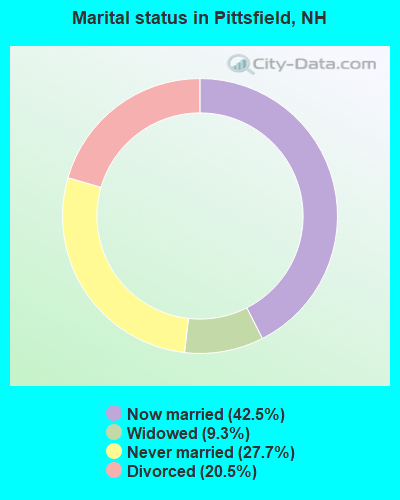
- Never married: 27.7%
- Now married: 42.5%
- Separated: 0.0%
- Widowed: 9.3%
- Divorced: 20.5%
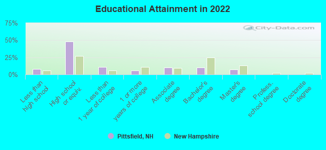
For population 25 years and over in Pittsfield:
- High school or higher: 90.4%
- Bachelor's degree or higher: 15.6%
- Graduate or professional degree: 7.3%
- Unemployed: 2.1%
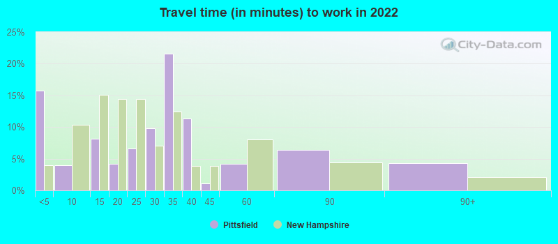
- Mean travel time to work (commute): 28.1 minutes
| Here: | 8.2 |
| New Hampshire average: | 10.3 |
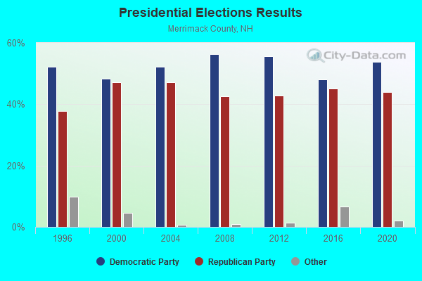
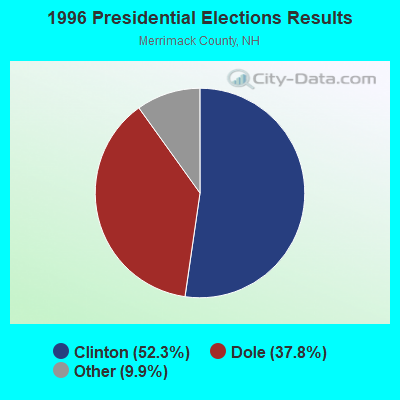
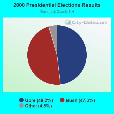
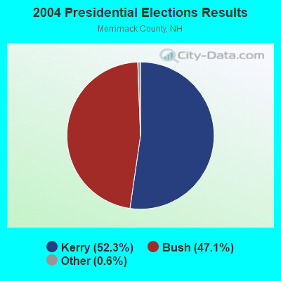

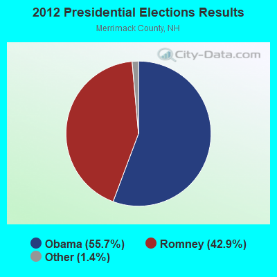
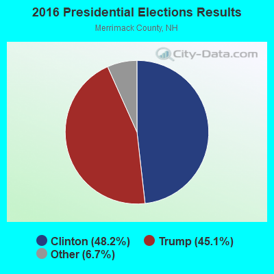
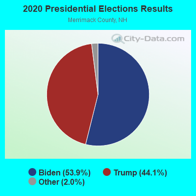
Graphs represent county-level data. Detailed 2008 Election Results
Religion statistics for Pittsfield, NH (based on Merrimack County data)
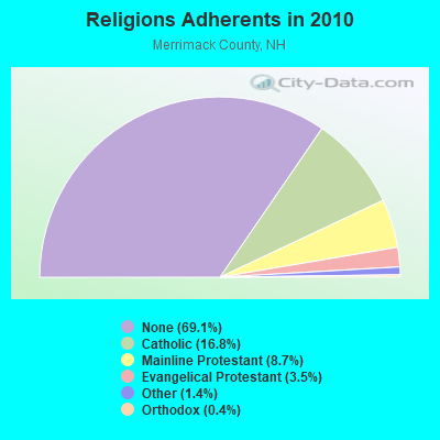
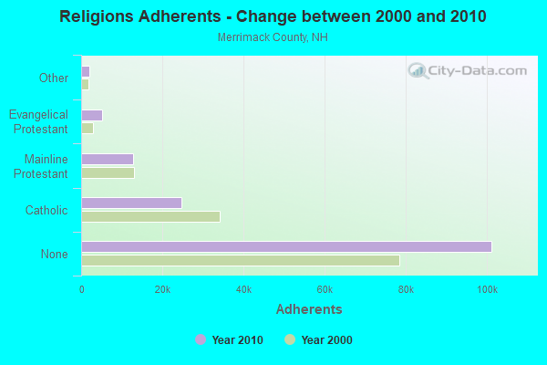
| Religion | Adherents | Congregations |
|---|---|---|
| Catholic | 24,654 | 7 |
| Mainline Protestant | 12,791 | 51 |
| Evangelical Protestant | 5,195 | 36 |
| Other | 2,097 | 15 |
| Orthodox | 580 | 2 |
| None | 101,128 | - |
Food Environment Statistics:
| Merrimack County: | 1.82 / 10,000 pop. |
| New Hampshire: | 2.14 / 10,000 pop. |
| Merrimack County: | 0.14 / 10,000 pop. |
| New Hampshire: | 0.15 / 10,000 pop. |
| Here: | 1.22 / 10,000 pop. |
| New Hampshire: | 1.78 / 10,000 pop. |
| This county: | 4.39 / 10,000 pop. |
| State: | 4.02 / 10,000 pop. |
| Merrimack County: | 7.77 / 10,000 pop. |
| New Hampshire: | 9.70 / 10,000 pop. |
| This county: | 7.4% |
| State: | 7.6% |
| Merrimack County: | 23.8% |
| New Hampshire: | 24.4% |
| Here: | 16.9% |
| New Hampshire: | 15.9% |
Health and Nutrition:
| Pittsfield: | 48.3% |
| New Hampshire: | 51.2% |
| This city: | 44.1% |
| State: | 49.1% |
| This city: | 30.2 |
| New Hampshire: | 28.5 |
| Here: | 23.9% |
| New Hampshire: | 20.9% |
| Pittsfield: | 19.5% |
| New Hampshire: | 9.3% |
| Pittsfield: | 6.8 |
| State: | 6.9 |
| This city: | 41.9% |
| New Hampshire: | 34.3% |
| Pittsfield: | 53.2% |
| New Hampshire: | 58.1% |
| Here: | 78.2% |
| New Hampshire: | 79.1% |
More about Health and Nutrition of Pittsfield, NH Residents
| Businesses in Pittsfield, NH | ||||
| Name | Count | Name | Count | |
|---|---|---|---|---|
| Ace Hardware | 1 | Rite Aid | 1 | |
| Dunkin Donuts | 1 | U-Haul | 1 | |
| GNC | 1 | |||
Strongest AM radio stations in Pittsfield:
- WGIN (930 AM; 10 kW; ROCHESTER, NH; Owner: CAPSTAR TX LIMITED PARTNERSHIP)
- WRKO (680 AM; 50 kW; BOSTON, MA; Owner: ENTERCOM BOSTON LICENSE, LLC)
- WGIR (610 AM; 5 kW; MANCHESTER, NH; Owner: CAPSTAR TX LIMITED PARTNERSHIP)
- WEZS (1350 AM; 5 kW; LACONIA, NH; Owner: GARY W. HAMMOND)
- WEEI (850 AM; 50 kW; BOSTON, MA; Owner: ENTERCOM BOSTON LICENSE, LLC)
- WCRN (830 AM; 50 kW; WORCESTER, MA; Owner: CARTER BROADCASTING CORPORATION)
- WBZ (1030 AM; 50 kW; BOSTON, MA; Owner: INFINITY BROADCASTING OPERATIONS, INC.)
- WASR (1420 AM; 5 kW; WOLFEBORO, NH; Owner: RADIO WOLFEBORO, INC.)
- WKOX (1200 AM; 50 kW; FRAMINGHAM, MA; Owner: CAPSTAR TX LIMITED PARTNERSHIP)
- WWZN (1510 AM; 50 kW; BOSTON, MA; Owner: ROSE CITY RADIO CORPORATION)
- WDER (1320 AM; 10 kW; DERRY, NH; Owner: BLOUNT COMMUNICATIONS, INC. OF NH)
- WKBR (1250 AM; 5 kW; MANCHESTER, NH; Owner: DEVON BROADCASTING COMPANY, INC.)
- WBIX (1060 AM; 40 kW; NATICK, MA; Owner: LANGER BROADCASTING CORPORATION)
Strongest FM radio stations in Pittsfield:
- WMEX (106.5 FM; FARMINGTON, NH; Owner: WIMMEX, LLC)
- WNHI (93.3 FM; BELMONT, NH; Owner: CONCORD BROADCASTING, L.L.C.)
- W282AF (104.3 FM; CONCORD, NH; Owner: CONCORD BIBLE FELLOWSHIP)
- WVNH (91.1 FM; CONCORD, NH; Owner: NEW HAMPSHIRE GOSPEL RADIO, INC.)
- WJYY (105.5 FM; CONCORD, NH; Owner: CONCORD BROADCASTING, L.L.C.)
- WLKZ (104.9 FM; WOLFEBORO, NH; Owner: TELE-MEDIA COMPANY OF NEW HAMPSHIRE, L.L.C.)
- WSCY (106.9 FM; MOULTONBOROUGH, NH; Owner: NORTHEAST COMMUNICATIONS CORPORATION)
- WPKQ (103.7 FM; NORTH CONWAY, NH; Owner: CITADEL BROADCASTING COMPANY)
- WHOM (94.9 FM; MT. WASHINGTON, NH; Owner: CITADEL BROADCASTING COMPANY)
- WGIR-FM (101.1 FM; MANCHESTER, NH; Owner: CAPSTAR TX LIMITED PARTNERSHIP)
- WQLL (96.5 FM; BEDFORD, NH; Owner: SAGA COMMUNICATIONS OF NEW ENGLAND, LLC)
- WHDQ (106.1 FM; CLAREMONT, NH; Owner: GREAT NORTHERN RADIO, L.L.C.)
- WLMW (90.7 FM; MANCHESTER, NH; Owner: KNOWLEDGE FOR LIFE)
- WZID (95.7 FM; MANCHESTER, NH; Owner: SAGA COMMUNICATIONS OF NEW ENGLAND, LLC)
- WVFM (105.7 FM; CAMPTON, NH; Owner: DEVON BROADCASTING COMPANY, INC.)
- WEVO (89.1 FM; CONCORD, NH; Owner: NEW HAMPSHIRE PUBLIC RADIO)
- WMEA (90.1 FM; PORTLAND, ME; Owner: MAINE PUBLIC BROADCASTING CORPORATION)
- WPNH-FM (100.1 FM; PLYMOUTH, NH; Owner: NORTHEAST COMMUNICATIONS CORPORATION)
- WOKQ (97.5 FM; DOVER, NH; Owner: CITADEL BROADCASTING COMPANY)
- WFTN-FM (94.1 FM; FRANKLIN, NH; Owner: NORTHEAST COMMUNICATIONS CORPORATION)
TV broadcast stations around Pittsfield:
- WENH-TV (Channel 11; DURHAM, NH; Owner: UNIVERSITY OF NEW HAMPSHIRE)
- WMEA-TV (Channel 26; BIDDEFORD, ME; Owner: MAINE PUBLIC BROADCASTING CORP.)
- WPXG (Channel 21; CONCORD, NH; Owner: PAXSON BOSTON-68 LICENSE, INC.)
- WMTW-TV (Channel 8; POLAND SPRING, ME; Owner: WMTW BROADCAST GROUP, LLC)
- WCSH (Channel 6; PORTLAND, ME; Owner: PACIFIC AND SOUTHERN COMPANY, INC.)
- WHDN-LP (Channel 26; BOSTON, MA; Owner: GUENTER MARKSTEINER)
- WFXZ-CA (Channel 24; BOSTON, MA; Owner: BOSTON BROADCASTING CORP.)
- Pittsfield, New Hampshire
- Fatal accident count13
- Vehicles involved in fatal accidents19
- Fatal accidents involving drunk persons:7
- Fatalities14
- Persons involved in fatal accidents28
- Pedestrians involved in fatal accidents0
- New Hampshire average
- Fatal accident count1264
- Vehicles involved in fatal accidents1873
- Fatal accidents involving drunk persons425
- Fatalities1365
- Persons involved in fatal accidents2802
- Pedestrians involved in fatal accidents177
- National Bridge Inventory (NBI) Statistics
- 3Number of bridges
- 26ft / 7.8mTotal length
- $9,426,000Total costs
- 7,000Total average daily traffic
- 535Total average daily truck traffic
- 10,359Total future (year 2042) average daily traffic
FCC Registered Cell Phone Towers:
1 (See the full list of FCC Registered Cell Phone Towers in Pittsfield)FCC Registered Antenna Towers:
23 (See the full list of FCC Registered Antenna Towers)FCC Registered Broadcast Land Mobile Towers:
4- Fire Station 3 Catamount St (Lat: 43.302861 Lon: -71.322556), Call Sign: KZO330,
Assigned Frequencies: 154.235 MHz, 154.355 MHz, 154.415 MHz, Grant Date: 11/12/2014, Expiration Date: 11/14/2024, Registrant: 2-Way Communications Service, Inc., 23 River Road, Newington, NH 03810-2832, Phone: (603) 431-6288, Fax: (603) 431-4832, Email:
- TOWN HALL, 85 Main St (Lat: 43.302333 Lon: -71.324778), Type: Mast, Structure height: 13.7 m, Overall height: 19.8 m, Call Sign: KNEN395,
Assigned Frequencies: 155.895 MHz, Grant Date: 12/07/2022, Expiration Date: 01/08/2033, Registrant: 2-Way Communications Service, Inc., 19 Durham Street, Portsmouth, NH 03801-2872, Phone: (603) 431-6288, Email:
- Lat: 43.283417 Lon: -71.316167, Call Sign: WRCY529,
Assigned Frequencies: 173.312 MHz, 173.312 MHz, Grant Date: 02/26/2019, Expiration Date: 02/26/2029, Certifier: Peter Szunowsky, Registrant: Cara Enterprises.Inc, Las Vegas, NV 89140-0124, Phone: (702) 838-9728, Fax: (702) 363-4607, Email:
- 30 Watson Street (Lat: 43.308444 Lon: -71.331111), Type: Pole, Structure height: 12 m, Overall height: 15 m, Call Sign: WRJT720,
Assigned Frequencies: 1.64000 MHz, Grant Date: 10/27/2020, Expiration Date: 10/27/2030, Certifier: Robert Freese, Registrant: Information Station Specialists, Zeeland, MI 49464, Phone: (616) 772-2300, Fax: (616) 772-2966
FCC Registered Microwave Towers:
3- PITTSFIELD, Various Locations (Lat: 43.351167 Lon: -71.435333), Overall height: 6.1 m, Call Sign: WPJD570, Licensee ID: L00050968,
Assigned Frequencies: 956.356 MHz, Grant Date: 03/12/2021, Expiration Date: 03/12/2031, Registrant: Energynorth Natural Gas Corp.
- PITTSFIELD, Atop Nudds Hill (Lat: 43.266667 Lon: -71.341667), Type: Gtower, Structure height: 54.9 m, Overall height: 60.7 m, Call Sign: WPOQ323,
Assigned Frequencies: 6123.10 MHz, Grant Date: 11/20/2018, Expiration Date: 11/09/2028, Certifier: Steven T Campbell, Registrant: Wilkinson Barker Knauer, LLP, 1800 M Street Nw, Suite 800n, Washington, DC 20036, Phone: (202) 383-3420, Fax: (202) 783-5851, Email:
- CATAMOUNT, 35 Mountain Road (Lat: 43.275500 Lon: -71.295333), Type: Gtower, Structure height: 45.7 m, Call Sign: WQNF662,
Assigned Frequencies: 10915.0 MHz, 5945.20 MHz, 5974.85 MHz, 10915.0 MHz, 10915.0 MHz, 10915.0 MHz, 5945.20 MHz, 5974.85 MHz, 10915.0 MHz, 5945.20 MHz... (+14 more), Grant Date: 11/05/2020, Expiration Date: 01/21/2031, Certifier: Dena Delucca, Registrant: New Hampshire Electric Cooperative, 579 Tenney Mountain Highway, Plymouth, NH 03264, Phone: (603) 536-1800, Email:
FCC Registered Amateur Radio Licenses:
30 (See the full list of FCC Registered Amateur Radio Licenses in Pittsfield)FAA Registered Aircraft Manufacturers and Dealers:
2 (See the full list of FAA Registered Manufacturers and Dealers in Pittsfield)FAA Registered Aircraft:
6 (See the full list of FAA Registered Aircraft)2002 - 2018 National Fire Incident Reporting System (NFIRS) incidents
- Fire incident types reported to NFIRS in Pittsfield, NH
- 39974.3%Structure Fires
- 8014.9%Outside Fires
- 336.1%Mobile Property/Vehicle Fires
- 254.7%Other
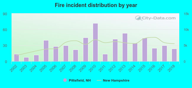 According to the data from the years 2002 - 2018 the average number of fire incidents per year is 32. The highest number of reported fires - 72 took place in 2010, and the least - 8 in 2003. The data has a rising trend.
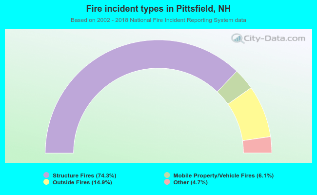 When looking into fire subcategories, the most reports belonged to: Structure Fires (74.3%), and Outside Fires (14.9%).
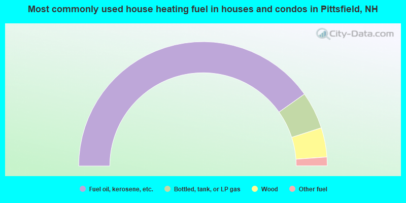
- 80.3%Fuel oil, kerosene, etc.
- 9.7%Bottled, tank, or LP gas
- 7.6%Wood
- 2.3%Other fuel
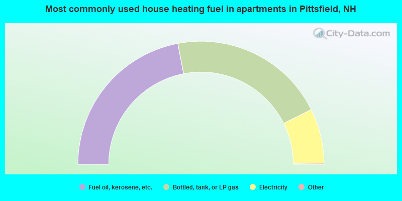
- 44.1%Fuel oil, kerosene, etc.
- 41.5%Bottled, tank, or LP gas
- 14.4%Electricity
Pittsfield compared to New Hampshire state average:
- Median household income below state average.
- Median house value below state average.
- Unemployed percentage significantly below state average.
- Black race population percentage significantly below state average.
- Hispanic race population percentage significantly below state average.
- Median age significantly below state average.
- Foreign-born population percentage significantly below state average.
- Renting percentage above state average.
- Length of stay since moving in significantly above state average.
- House age above state average.
- Percentage of population with a bachelor's degree or higher below state average.
Pittsfield on our top lists:
- #22 on the list of "Top 101 cities with the most residents born in Bangladesh (population 500+)"
- #30 on the list of "Top 101 counties with the lowest number of births per 1000 residents 2007-2013"
- #37 on the list of "Top 101 counties with the best general health status score of residents (1-5), 3 years of data"
- #46 on the list of "Top 101 counties with the highest percentage of residents that visited a dentist within the past year"
- #68 on the list of "Top 101 counties with the highest percentage of residents that keep firearms around their homes"
- #73 on the list of "Top 101 counties with the lowest Sulfur Oxides Annual air pollution readings in 2012 (µg/m3)"

|
|
Total of 11 patent applications in 2008-2024.