Poor Fork, Kentucky
Submit your own pictures of this place and show them to the world
- OSM Map
- General Map
- Google Map
- MSN Map

| Males: 581 | |
| Females: 615 |
| Median resident age: | 39.8 years |
| Kentucky median age: | 35.9 years |
Zip code: 40870
| Poor Fork: | $46,094 |
| KY: | $59,341 |
Estimated per capita income in 2022: $27,658 (it was $15,408 in 2000)
Poor Fork CCD income, earnings, and wages data
Estimated median house or condo value in 2022: $82,229 (it was $39,100 in 2000)
| Poor Fork: | $82,229 |
| KY: | $196,300 |
Mean prices in 2022: all housing units: $102,372; detached houses: $112,042; townhouses or other attached units: $117,777; in 2-unit structures: $250,926; mobile homes: $57,021
Detailed information about poverty and poor residents in Poor Fork, KY


- 1,24798.1%White alone
- 151.2%Hispanic
- 60.5%Two or more races
- 20.2%American Indian alone
- 10.08%Asian alone

Races in Poor Fork detailed stats: ancestries, foreign born residents, place of birth
 Recent articles from our blog. Our writers, many of them Ph.D. graduates or candidates, create easy-to-read articles on a wide variety of topics.

Current Local Time: EST time zone
Land area: 28.0 square miles.
Population density: 43 people per square mile (very low).

| Poor Fork CCD: | 0.9% ($353) |
| Kentucky: | 0.8% ($610) |
Nearest city with pop. 50,000+: Johnson City, TN  (60.3 miles , pop. 55,469).
Nearest city with pop. 200,000+: Fayette, KY (105.4 miles , pop. 260,512).
Nearest city with pop. 1,000,000+: Chicago, IL (416.6 miles , pop. 2,896,016).
Nearest cities:
), ), ), ), )Latitude: 36.92 N, Longitude: 83.18 W
Area code commonly used in this area: 606


| Here: | 5.9% |
| Kentucky: | 3.8% |

- Health care (17.3%)
- Mining, quarrying, oil & gas extraction (14.9%)
- Public administration (9.1%)
- Construction (8.9%)
- Educational services (8.4%)
- Accommodation & food services (6.4%)
- Department & other general merchandise stores (5.3%)

- Mining, quarrying, oil & gas extraction (21.8%)
- Construction (15.3%)
- Public administration (12.6%)
- Agriculture, forestry, fishing & hunting (6.1%)
- Health care (6.1%)
- Food & beverage stores (5.7%)
- Accommodation & food services (5.4%)

- Health care (32.8%)
- Educational services (20.1%)
- Department & other general merchandise stores (12.7%)
- Accommodation & food services (7.9%)
- Mining, quarrying, oil & gas extraction (5.3%)
- Used merchandise, gift, novelty, souvenir, other miscellaneous stores (4.8%)
- Public administration (4.2%)

- Extraction workers (7.3%)
- Registered nurses (5.8%)
- Construction traders workers except carpenters, electricians, painters, plumbers, and construction laborers (4.9%)
- Other office and administrative support workers, including supervisors (4.4%)
- Preschool, kindergarten, elementary, and middle school teachers (4.2%)
- Driver/sales workers and truck drivers (4.0%)
- Vehicle and mobile equipment mechanics, installers, and repairers (4.0%)

- Extraction workers (12.6%)
- Construction traders workers except carpenters, electricians, painters, plumbers, and construction laborers (8.4%)
- Vehicle and mobile equipment mechanics, installers, and repairers (6.9%)
- Driver/sales workers and truck drivers (6.9%)
- Law enforcement workers, including supervisors (5.0%)
- Material recording, scheduling, dispatching, and distributing workers (4.6%)
- Carpenters (4.2%)

- Registered nurses (13.8%)
- Preschool, kindergarten, elementary, and middle school teachers (10.1%)
- Secretaries and administrative assistants (9.0%)
- Other office and administrative support workers, including supervisors (7.9%)
- Cashiers (7.4%)
- Information and record clerks, except customer service representatives (6.9%)
- Nursing, psychiatric, and home health aides (5.3%)
Average climate in Poor Fork, Kentucky
Based on data reported by over 4,000 weather stations


Tornado activity:
Poor Fork-area historical tornado activity is significantly below Kentucky state average. It is 63% smaller than the overall U.S. average.
On 5/9/1988, a category F3 (max. wind speeds 158-206 mph) tornado 34.5 miles away from the Poor Fork place center killed one person and injured 15 people and caused between $5,000,000 and $50,000,000 in damages.
On 7/6/1980, a category F2 (max. wind speeds 113-157 mph) tornado 24.1 miles away from the place center caused between $50,000 and $500,000 in damages.
Earthquake activity:
Poor Fork-area historical earthquake activity is significantly above Kentucky state average. It is 46% greater than the overall U.S. average.On 7/27/1980 at 18:52:21, a magnitude 5.2 (5.1 MB, 4.7 MS, 5.0 UK, 5.2 UK, Class: Moderate, Intensity: VI - VII) earthquake occurred 98.2 miles away from Poor Fork center
On 8/9/2020 at 12:07:37, a magnitude 5.1 (5.1 MW, Depth: 4.7 mi) earthquake occurred 119.5 miles away from the city center
On 8/23/2011 at 17:51:04, a magnitude 5.8 (5.8 MW, Depth: 3.7 mi) earthquake occurred 295.7 miles away from the city center
On 11/30/1973 at 07:48:41, a magnitude 4.7 (4.7 MB, 4.6 ML, Class: Light, Intensity: IV - V) earthquake occurred 89.2 miles away from Poor Fork center
On 9/7/1988 at 02:28:09, a magnitude 4.6 (4.5 MB, 4.6 LG) earthquake occurred 92.8 miles away from Poor Fork center
On 11/10/2012 at 17:08:14, a magnitude 4.2 (4.2 MW, Depth: 10.6 mi) earthquake occurred 16.4 miles away from the city center
Magnitude types: regional Lg-wave magnitude (LG), body-wave magnitude (MB), local magnitude (ML), surface-wave magnitude (MS), moment magnitude (MW)
Natural disasters:
The number of natural disasters in Harlan County (21) is greater than the US average (15).Major Disasters (Presidential) Declared: 14
Emergencies Declared: 2
Causes of natural disasters: Floods: 14, Storms: 11, Mudslides: 6, Landslides: 5, Tornadoes: 4, Winter Storms: 3, Fires: 2, Snows: 2, Snowstorms: 2, Winds: 2, Blizzard: 1, Freeze: 1, Hurricane: 1, Snowfall: 1, Other: 1 (Note: some incidents may be assigned to more than one category).
Colleges/universities with over 2000 students nearest to Poor Fork:
- Southeast Kentucky Community and Technical College (about 11 miles; Cumberland, KY; Full-time enrollment: 2,196)
- Hazard Community and Technical College (about 22 miles; Hazard, KY; FT enrollment: 2,087)
- Lincoln Memorial University (about 36 miles; Harrogate, TN; FT enrollment: 3,706)
- Walters State Community College (about 50 miles; Morristown, TN; FT enrollment: 4,359)
- Northeast State Community College (about 53 miles; Blountville, TN; FT enrollment: 4,480)
- University of the Cumberlands (about 57 miles; Williamsburg, KY; FT enrollment: 3,585)
- Tusculum College (about 57 miles; Greeneville, TN; FT enrollment: 2,070)
Points of interest:
Notable locations in Poor Fork: Harlan County Forestry Camp (A), Jacks Gap Rock (B), Putney Fire Department (C). Display/hide their locations on the map
Churches in Poor Fork include: Creech Chapel (A), Rhea Church (B). Display/hide their locations on the map
Cemeteries: Howard Cemetery (1), Wilder Cemetery (2), Sergent Cemetery (3). Display/hide their locations on the map
Streams, rivers, and creeks: Chads Branch (A), Chumney Branch (B), Clover Gap Branch (C), Deep Branch (D), Dora Branch (E), Dry Branch (F), Eloise Branch (G), Henry Branch (H), Holcomb Branch (I). Display/hide their locations on the map
| This place: | 2.4 people |
| Kentucky: | 2.5 people |
| This place: | 71.7% |
| Whole state: | 66.9% |
| This place: | 4.5% |
| Whole state: | 6.4% |
Likely homosexual households (counted as self-reported same-sex unmarried-partner households)
- Lesbian couples: 0.0% of all households
- Gay men: 0.6% of all households
| This place: | 19.8% |
| Whole state: | 15.8% |
| This place: | 9.7% |
| Whole state: | 6.6% |
For population 15 years and over in Poor Fork:

- Never married: 21.1%
- Now married: 59.4%
- Separated: 1.0%
- Widowed: 9.7%
- Divorced: 9.8%
For population 25 years and over in Poor Fork:
- High school or higher: 66.8%
- Bachelor's degree or higher: 7.0%
- Graduate or professional degree: 2.3%
- Unemployed: 11.4%
- Mean travel time to work (commute): 28.9 minutes


| Here: | 11.8 |
| Kentucky average: | 13.8 |
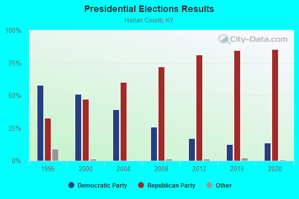
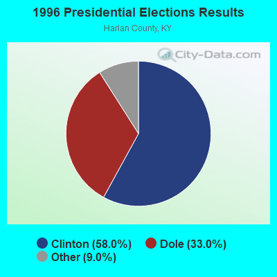
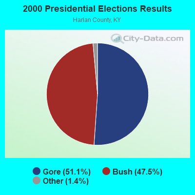
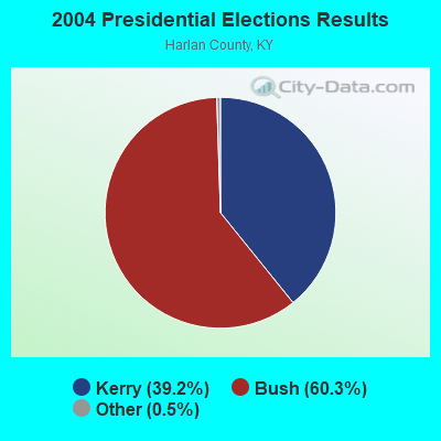
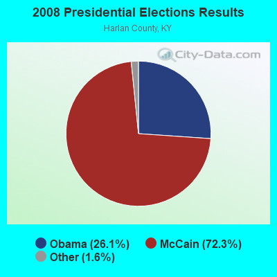
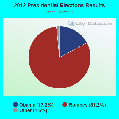

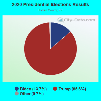
Graphs represent county-level data. Detailed 2008 Election Results
Religion statistics for Poor Fork, KY (based on Harlan County data)
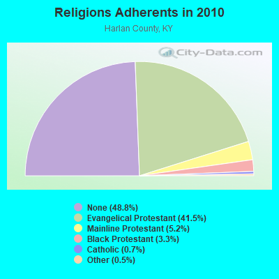
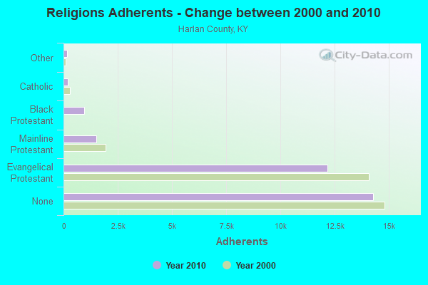
| Religion | Adherents | Congregations |
|---|---|---|
| Evangelical Protestant | 12,152 | 95 |
| Mainline Protestant | 1,524 | 13 |
| Black Protestant | 968 | 3 |
| Catholic | 207 | 3 |
| Other | 151 | 2 |
| None | 14,276 | - |
Food Environment Statistics:
| Harlan County: | 3.22 / 10,000 pop. |
| Kentucky: | 2.19 / 10,000 pop. |
| Harlan County: | 0.64 / 10,000 pop. |
| State: | 0.74 / 10,000 pop. |
| Harlan County: | 4.18 / 10,000 pop. |
| Kentucky: | 4.36 / 10,000 pop. |
| Harlan County: | 2.57 / 10,000 pop. |
| Kentucky: | 5.74 / 10,000 pop. |
| Harlan County: | 12.9% |
| State: | 11.0% |
| Here: | 29.8% |
| Kentucky: | 30.0% |
| This county: | 21.0% |
| Kentucky: | 15.9% |
Strongest AM radio stations in Poor Fork:
- WFSR (970 AM; 5 kW; HARLAN, KY; Owner: EASTERN BROADCASTING COMPAY)
- WHLN (1410 AM; 5 kW; HARLAN, KY)
- WKVL (850 AM; daytime; 50 kW; KNOXVILLE, TN; Owner: HORNE RADIO, LLC)
- WKIC (1390 AM; 5 kW; HAZARD, KY)
- WSWV (1570 AM; 2 kW; PENNINGTON GAP, VA; Owner: IBS COMMUNICATIONS, L.L.C.)
- WCPM (1280 AM; 1 kW; CUMBERLAND, KY; Owner: CUMBERLAND CITY BROADCASTING, INC.)
- WTCW (920 AM; 4 kW; WHITESBURG, KY; Owner: T.C.W. BROADCASTING , INC.)
- WGOC (640 AM; 10 kW; BLOUNTVILLE, TN; Owner: CITADEL BROADCASTING COMPANY)
- WFGW (1010 AM; 50 kW; BLACK MOUNTAIN, NC; Owner: BLUE RIDGE BROADCASTING CORP.)
- WPWT (870 AM; daytime; 10 kW; COLONIAL HEIGHTS, TN; Owner: INFORMATION COMMUNICATIONS CORP.)
- WZAP (690 AM; 10 kW; BRISTOL, VA; Owner: RAM COMMUNICATIONS, INC.)
- WNVA (1350 AM; 5 kW; NORTON, VA; Owner: RADIO-WISE, INC.)
- WHGG (1090 AM; daytime; 10 kW; KINGSPORT, TN; Owner: APPALACHIAN EDUCATIONAL COMMUNICATIO)
Strongest FM radio stations in Poor Fork:
- WTUK (105.1 FM; HARLAN, KY; Owner: EASTERN BROADCASTING COMPANY)
- WSEH (102.7 FM; CUMBERLAND, KY; Owner: CUMBERLAND CITY BROADCASTING, INC.)
- WAXM (93.5 FM; BIG STONE GAP, VA; Owner: VALLEY BROADCASTING, INC.)
- WSGS (101.1 FM; HAZARD, KY; Owner: MOUNTAIN BROADCASTING SERVICE, INC.)
- WEKH (90.9 FM; HAZARD, KY; Owner: EASTERN KENTUCKY UNIVERSITY)
- W223AA (92.5 FM; BIG STONE GAP, VA; Owner: VALLEY BROADCASTING, INC.)
- WIFX-FM (94.3 FM; JENKINS, KY; Owner: LETCHER COUNTY BROADCASTING, INC)
- WZQQ (97.9 FM; HYDEN, KY; Owner: LESLIE COUNTY BROADCASTING, INC.)
- WXKQ-FM (103.9 FM; WHITESBURG, KY; Owner: T.C.W. BROADCASTING , INC.)
- WMMT (88.7 FM; WHITESBURG, KY; Owner: APPALSHOP, INCORPORATED)
- WJMD (104.7 FM; HAZARD, KY; Owner: HAZARD BROADCASTING SERVICES)
- WTFM (98.5 FM; KINGSPORT, TN; Owner: HOLSTON VALLEY BROADCASTING CORP.)
- WJDT (106.5 FM; ROGERSVILLE, TN; Owner: C & S BROADCASTING)
- WDXC (102.3 FM; POUND, VA; Owner: WDXC RADIO, INC.)
- WJNV (99.1 FM; JONESVILLE, VA; Owner: REGINA KAY MOORE)
- WMIK-FM (92.7 FM; MIDDLESBORO, KY; Owner: GATEWAY BROADCASTING, INC.)
- WBGQ (100.7 FM; BULLS GAP, TN; Owner: CHEROKEE BROADCASTING)
- WRZK (95.9 FM; COLONIAL HEIGHTS, TN; Owner: MURRAY COMMUNICATIONS)
- WHCB (91.5 FM; BRISTOL, TN; Owner: APPALACHIAN EDUC. COMMUNICATION CORP)
- WRIL (106.3 FM; PINEVILLE, KY; Owner: PINE HILLS BROADCASTING, INC.)
TV broadcast stations around Poor Fork:
- WYMT-TV (Channel 57; HAZARD, KY; Owner: WYMT LICENSEE CORP.)
- W24BT (Channel 24; TALBERT, KY; Owner: MS COMMUNICATIONS, LLC)
- WAGV (Channel 44; HARLAN, KY; Owner: LIVING FAITH MINISTRIES, INC.)
- W31BU (Channel 31; TALBERT, KY; Owner: MS COMMUNICATIONS, LLC)
- W53BQ (Channel 53; TALBERT, KY; Owner: MS COMMUNICATIONS, LLC)
- W69ED (Channel 69; TALBERT, KY; Owner: MS COMMUNICATIONS, LLC)
- WKHA (Channel 35; HAZARD, KY; Owner: KENTUCKY AUTHORITY FOR EDUCATIONAL TV)
- W26BK (Channel 26; TALBERT, KY; Owner: MS COMMUNICATIONS, LLC)
- W16BI (Channel 16; TALBERT, KY; Owner: MS COMMUNICATIONS, LLC)

- 77.5%Electricity
- 12.9%Fuel oil, kerosene, etc.
- 5.5%Bottled, tank, or LP gas
- 1.5%Wood
- 1.3%Utility gas
- 1.3%No fuel used

- 52.6%Electricity
- 35.1%Fuel oil, kerosene, etc.
- 12.3%Coal or coke
Poor Fork compared to Kentucky state average:
- Median house value significantly below state average.
- Black race population percentage significantly below state average.
- Hispanic race population percentage significantly below state average.
- Foreign-born population percentage significantly below state average.
- Renting percentage below state average.
- Length of stay since moving in significantly above state average.
- Number of rooms per house significantly below state average.
- House age significantly below state average.
- Percentage of population with a bachelor's degree or higher significantly below state average.