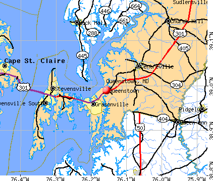
Queenstown, Maryland
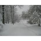
Queenstown: Queenstown winter storm Mar 1-2, 2009
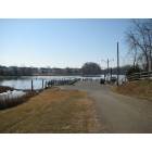
Queenstown: Queenstown Harbor Winter 2009
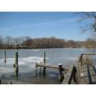
Queenstown: Clear winter day in Queenstown Harbor
- add
your


Submit your own pictures of this town and show them to the world
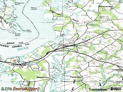
- OSM Map
- General Map
- Google Map
- MSN Map
Population change since 2000: +20.1%
 |
| Males: 319 | |
| Females: 422 |
| Median resident age: | 35.8 years |
| Maryland median age: | 39.7 years |
Zip codes: 21658.
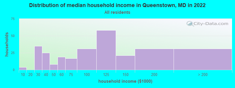
| Queenstown: | $98,371 |
| MD: | $94,991 |
Estimated per capita income in 2022: $40,462 (it was $24,185 in 2000)
Queenstown town income, earnings, and wages data
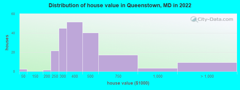
Estimated median house or condo value in 2022: $351,542 (it was $131,700 in 2000)
| Queenstown: | $351,542 |
| MD: | $398,100 |
Mean prices in 2022: all housing units: $414,125; detached houses: $417,656; townhouses or other attached units: $362,734
Median gross rent in 2022: $1,682.
(2.2% for White Non-Hispanic residents, 70.2% for Black residents, 34.0% for Hispanic or Latino residents, 93.2% for other race residents, 1.9% for two or more races residents)
Detailed information about poverty and poor residents in Queenstown, MD


Compare current foreclosures near Queenstown, MD:
| Photo | Address | Area | Beds / Baths | Price | Details |
|---|---|---|---|---|---|

|
#1
Grason Vista Dr
Queenstown, MD 21658
|
3,410 sq. feet
|
2 baths - beds |
show details | |

|
#2
River Run
Queenstown, MD 21658
|
2,576 sq. feet
|
2 baths - beds |
show details | |

|
#3
Overlook Dr
Queenstown, MD 21658
|
2,624 sq. feet
|
2 baths - beds |
show details | |

|
#4
Governors Way S
Queenstown, MD 21658
|
2,910 sq. feet
|
2 baths - beds |
show details | |

|
#5
Marlborough Rd
Queenstown, MD 21658
|
- sq. feet
|
- baths - beds |
show details | |

|
#6
Skipton Cordova Rd
Cordova, MD 21625
|
1,256 sq. feet
|
2 baths 2 beds |
$128,250
|
show details |

|
#7
Sherman Dr
Chester, MD 21619
|
1,560 sq. feet
|
2 baths 4 beds |
show details | |

|
#8
D Queen Mary Ct.
Chester, MD 21619
|
1,380 sq. feet
|
2 baths 2 beds |
show details | |

|
#9
Teal Ct # B
Chester, MD 21619
|
1,073 sq. feet
|
2 baths - beds |
show details | |

|
#10
Kentmorr Rd
Stevensville, MD 21666
|
2,076 sq. feet
|
2 baths - beds |
show details |
| Photo | Address | Area | Beds / Baths | Price | Details |
|---|---|---|---|---|---|

|
#11
N Maple Ave
Ridgely, MD 21660
|
814 sq. feet
|
1 baths - beds |
show details | |

|
#12
Secretariat Dr
Annapolis, MD 21409
|
1,160 sq. feet
|
1 baths - beds |
show details | |

|
#13
Rock Hall Ave
Rock Hall, MD 21661
|
2,414 sq. feet
|
2 baths - beds |
show details | |

|
#14
Roe Ingleside Rd
Centreville, MD 21617
|
2,522 sq. feet
|
2 baths - beds |
show details | |

|
#15
Windy Acres Farm Ln
Centreville, MD 21617
|
2,309 sq. feet
|
3 baths - beds |
show details | |

|
#16
S Talbot St
Saint Michaels, MD 21663
|
1,835 sq. feet
|
2 baths - beds |
show details | |

|
#17
W 3rd St
Ridgely, MD 21660
|
1,056 sq. feet
|
2 baths - beds |
show details | |

|
#18
Marshall Dr
Centreville, MD 21617
|
3,778 sq. feet
|
2 baths - beds |
show details | |

|
#19
Allen Ave
Stevensville, MD 21666
|
1,708 sq. feet
|
2 baths - beds |
show details | |

|
#20
Petunia Dr
Easton, MD 21601
|
2,200 sq. feet
|
1 baths - beds |
show details |
| Photo | Address | Area | Beds / Baths | Price | Details |
|---|---|---|---|---|---|

|
#21
Walnut St
Church Hill, MD 21623
|
1,848 sq. feet
|
1 baths - beds |
show details | |

|
#22
Chapel Rd
Cordova, MD 21625
|
1,160 sq. feet
|
1 baths - beds |
show details | |

|
#23
Central Ave
Ridgely, MD 21660
|
1,248 sq. feet
|
2 baths - beds |
show details | |

|
#24
Flat Iron Square Rd
Church Hill, MD 21623
|
2,046 sq. feet
|
2 baths - beds |
show details | |

|
#25
Upland Ln
Centreville, MD 21617
|
4,948 sq. feet
|
3 baths - beds |
show details | |

|
#26
Hillsboro Rd
Denton, MD 21629
|
1,716 sq. feet
|
1 baths - beds |
show details | |

|
#27
Pleasant Aly
Easton, MD 21601
|
1,008 sq. feet
|
1 baths - beds |
show details | |

|
#28
Colony Cir
Easton, MD 21601
|
1,920 sq. feet
|
2 baths - beds |
show details | |

|
#29
Duke Of Kent St
Chestertown, MD 21620
|
1,606 sq. feet
|
2 baths - beds |
show details | |

|
#30
Saint Margarets Rd
Annapolis, MD 21409
|
1,546 sq. feet
|
1 baths - beds |
show details |
| Photo | Address | Area | Beds / Baths | Price | Details |
|---|---|---|---|---|---|

|
#31
Middletown Rd
Annapolis, MD 21409
|
2,184 sq. feet
|
2 baths - beds |
show details | |

|
#32
W Lake Dr
Annapolis, MD 21403
|
4,452 sq. feet
|
5 baths - beds |
show details | |

|
#33
Cumberland St
Chestertown, MD 21620
|
880 sq. feet
|
1 baths - beds |
show details | |

|
#34
Tour Dr
Easton, MD 21601
|
1,756 sq. feet
|
2 baths - beds |
show details | |

|
#35
Ramblewood Ct
Annapolis, MD 21409
|
1,760 sq. feet
|
2 baths - beds |
show details | |

|
#36
Waverly Rd
Easton, MD 21601
|
2,102 sq. feet
|
1 baths - beds |
show details | |

|
#37
Duke Of Kent St
Chestertown, MD 21620
|
1,556 sq. feet
|
2 baths - beds |
show details | |

|
#38
Old Fairlee Rd
Chestertown, MD 21620
|
1,912 sq. feet
|
1 baths - beds |
show details | |

|
#39
Liberty Ln
Easton, MD 21601
|
1,732 sq. feet
|
3 baths - beds |
show details | |

|
#40
Penny Ln
Easton, MD 21601
|
1,520 sq. feet
|
2 baths - beds |
show details |
| Photo | Address | Area | Beds / Baths | Price | Details |
|---|---|---|---|---|---|

|
#41
Commanders Way S
Annapolis, MD 21409
|
1,280 sq. feet
|
1 baths - beds |
show details | |

|
#42
Hampton Rd
Annapolis, MD 21409
|
2,254 sq. feet
|
2 baths - beds |
show details | |

|
#43
Lincoln Ct
Easton, MD 21601
|
2,240 sq. feet
|
2 baths - beds |
show details | |

|
#44
Wye Oak St
Easton, MD 21601
|
2,060 sq. feet
|
2 baths - beds |
show details | |

|
#45
South St
Easton, MD 21601
|
864 sq. feet
|
1 baths - beds |
show details | |

|
#46
Sun Valley Dr
Annapolis, MD 21409
|
1,616 sq. feet
|
1 baths - beds |
show details | |

|
#47
Gannon Cir
Easton, MD 21601
|
1,856 sq. feet
|
2 baths - beds |
show details | |

|
#48
Longwoods Rd
Easton, MD 21601
|
2,266 sq. feet
|
3 baths - beds |
show details | |

|
#49
Utah Rd
Stevensville, MD 21666
|
2,438 sq. feet
|
2 baths - beds |
show details | |

|
Check over 1 million property listings on Foreclosure.com!
|
browse all offers | |||


- 44654.7%White alone
- 26232.1%Hispanic
- 9311.4%Black alone
- 111.3%Two or more races
- 20.2%Other race alone
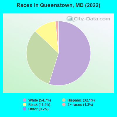
Races in Queenstown detailed stats: ancestries, foreign born residents, place of birth
According to our research of Maryland and other state lists, there was 1 registered sex offender living in Queenstown, Maryland as of April 23, 2024.
The ratio of all residents to sex offenders in Queenstown is 636 to 1.
 Recent articles from our blog. Our writers, many of them Ph.D. graduates or candidates, create easy-to-read articles on a wide variety of topics.


 | Close to Ocean City? (18 replies) |
| You know you are from Maryland or have lived in Maryland too long when... (76 replies) |
| Queenstown Outlet: How is it these days? (2 replies) |
| Study shows need for expanded Bay Bridge (29 replies) |
| Annapolis to Queenstown (5 replies) |
| Possible relocation to Stevensville/Kent Island area. Advice? (15 replies) |
Latest news from Queenstown, MD collected exclusively by city-data.com from local newspapers, TV, and radio stations
Ancestries: English (8.5%), German (6.7%), American (5.7%), Irish (4.8%), Scottish (3.2%), European (2.0%).
Current Local Time: EST time zone
Incorporated in 1892
Land area: 0.41 square miles.
Population density: 1,804 people per square mile (low).
92 residents are foreign born (10.4% Latin America).
| This town: | 11.3% |
| Maryland: | 15.7% |
Median real estate property taxes paid for housing units with mortgages in 2022: $2,797 (0.8%)
Median real estate property taxes paid for housing units with no mortgage in 2022: $2,924 (0.9%)
Nearest city with pop. 50,000+: Dundalk, MD  (26.8 miles , pop. 62,306).
Nearest city with pop. 200,000+: Baltimore, MD (33.1 miles , pop. 651,154).
Nearest city with pop. 1,000,000+: Philadelphia, PA (88.2 miles , pop. 1,517,550).
Nearest cities:
), ), ), ), Latitude: 38.99 N, Longitude: 76.16 W
Area code: 410

Queenstown tourist attractions:
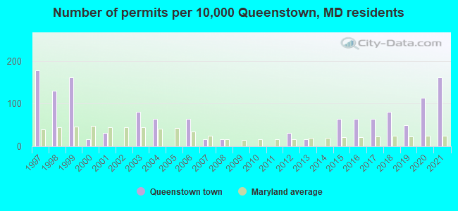
Single-family new house construction building permits:
- 2021: 10 buildings, average cost: $130,000
- 2020: 7 buildings, average cost: $147,100
- 2019: 3 buildings, average cost: $233,300
- 2018: 5 buildings, average cost: $230,500
- 2017: 4 buildings, average cost: $150,000
- 2016: 4 buildings, average cost: $185,300
- 2015: 4 buildings, average cost: $200,000
- 2013: 1 building, cost: $100,000
- 2012: 2 buildings, average cost: $90,000
- 2008: 1 building, cost: $250,000
- 2007: 1 building, cost: $100,000
- 2006: 4 buildings, average cost: $128,000
- 2004: 4 buildings, average cost: $177,500
- 2003: 5 buildings, average cost: $214,600
- 2001: 2 buildings, average cost: $92,500
- 2000: 1 building, cost: $175,000
- 1999: 10 buildings, average cost: $95,500
- 1998: 8 buildings, average cost: $69,400
- 1997: 11 buildings, average cost: $74,900

| Here: | 1.6% |
| Maryland: | 2.0% |
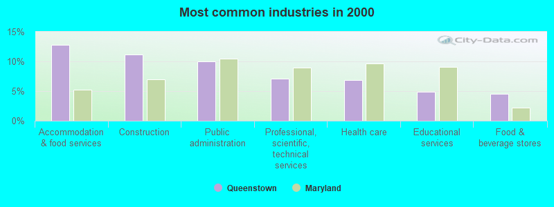
- Accommodation & food services (12.8%)
- Construction (11.1%)
- Public administration (10.0%)
- Professional, scientific, technical services (7.1%)
- Health care (6.8%)
- Educational services (4.8%)
- Food & beverage stores (4.6%)
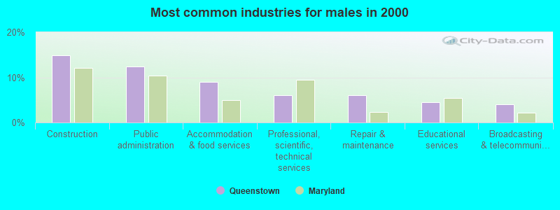
- Construction (14.9%)
- Public administration (12.4%)
- Accommodation & food services (9.0%)
- Professional, scientific, technical services (6.0%)
- Repair & maintenance (6.0%)
- Educational services (4.5%)
- Broadcasting & telecommunications (4.0%)
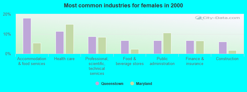
- Accommodation & food services (18.0%)
- Health care (11.3%)
- Professional, scientific, technical services (8.7%)
- Food & beverage stores (6.7%)
- Public administration (6.7%)
- Finance & insurance (6.7%)
- Construction (6.0%)
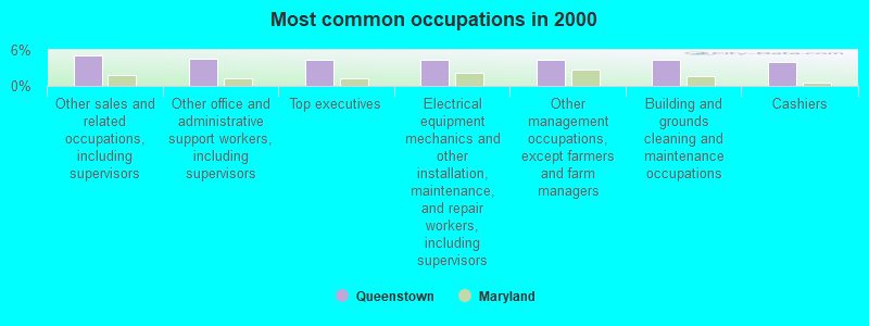
- Other sales and related occupations, including supervisors (5.1%)
- Other office and administrative support workers, including supervisors (4.6%)
- Top executives (4.3%)
- Electrical equipment mechanics and other installation, maintenance, and repair workers, including supervisors (4.3%)
- Other management occupations, except farmers and farm managers (4.3%)
- Building and grounds cleaning and maintenance occupations (4.3%)
- Cashiers (4.0%)
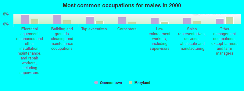
- Electrical equipment mechanics and other installation, maintenance, and repair workers, including supervisors (7.5%)
- Building and grounds cleaning and maintenance occupations (7.5%)
- Top executives (6.0%)
- Carpenters (5.5%)
- Law enforcement workers, including supervisors (5.0%)
- Sales representatives, services, wholesale and manufacturing (5.0%)
- Other management occupations, except farmers and farm managers (4.5%)
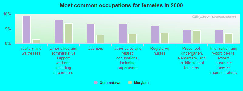
- Waiters and waitresses (9.3%)
- Other office and administrative support workers, including supervisors (8.0%)
- Cashiers (6.7%)
- Other sales and related occupations, including supervisors (6.7%)
- Registered nurses (6.0%)
- Preschool, kindergarten, elementary, and middle school teachers (4.7%)
- Information and record clerks, except customer service representatives (4.7%)
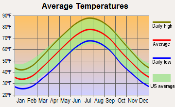
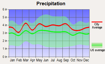
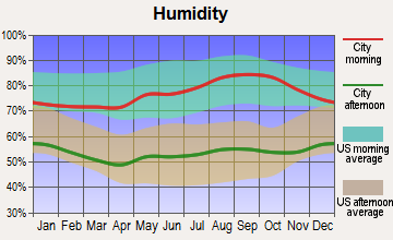
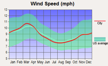
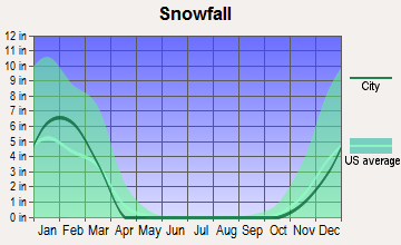
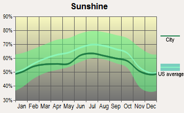
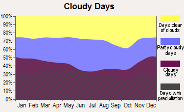
Average climate in Queenstown, Maryland
Based on data reported by over 4,000 weather stations
(lower is better)
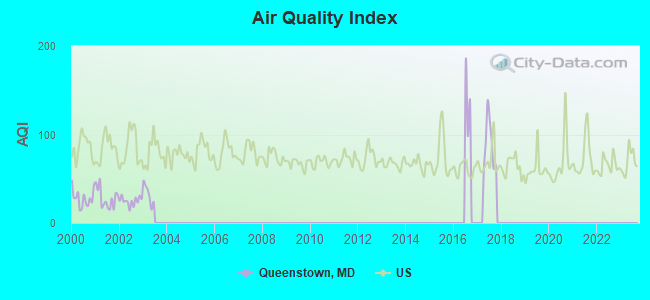
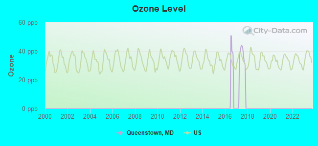
Air Quality Index (AQI) level in 2017 was 89.5. This is worse than average.
| City: | 89.5 |
| U.S.: | 72.6 |
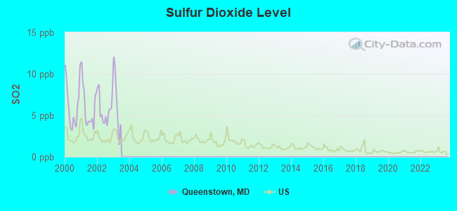
Sulfur Dioxide (SO2) [ppb] level in 2002 was 5.75. This is significantly worse than average. Closest monitor was 18.7 miles away from the city center.
| City: | 5.75 |
| U.S.: | 1.51 |
Tornado activity:
Queenstown-area historical tornado activity is near Maryland state average. It is 6% smaller than the overall U.S. average.
On 4/28/2002, a category F4 (max. wind speeds 207-260 mph) tornado 39.8 miles away from the Queenstown town center killed 3 people and injured 122 people and caused $124 million in damages.
On 6/9/1961, a category F3 (max. wind speeds 158-206 mph) tornado 28.7 miles away from the town center caused between $50,000 and $500,000 in damages.
Earthquake activity:
Queenstown-area historical earthquake activity is significantly above Maryland state average. It is 62% smaller than the overall U.S. average.On 8/23/2011 at 17:51:04, a magnitude 5.8 (5.8 MW, Depth: 3.7 mi, Class: Moderate, Intensity: VI - VII) earthquake occurred 121.9 miles away from the city center
On 1/16/1994 at 01:49:16, a magnitude 4.6 (4.6 MB, 4.6 LG, Depth: 3.1 mi, Class: Light, Intensity: IV - V) earthquake occurred 93.0 miles away from the city center
On 8/25/2011 at 05:07:52, a magnitude 4.5 (4.5 ML, Depth: 4.2 mi) earthquake occurred 121.7 miles away from Queenstown center
On 11/30/2017 at 21:47:31, a magnitude 4.1 (4.1 MW, Depth: 6.1 mi) earthquake occurred 41.5 miles away from the city center
On 12/9/2003 at 20:59:18, a magnitude 4.5 (4.5 ML, Depth: 6.2 mi) earthquake occurred 134.8 miles away from Queenstown center
On 12/9/2003 at 20:59:14, a magnitude 4.5 (4.5 MB, 4.5 LG) earthquake occurred 135.6 miles away from Queenstown center
Magnitude types: regional Lg-wave magnitude (LG), body-wave magnitude (MB), local magnitude (ML), moment magnitude (MW)
Natural disasters:
The number of natural disasters in Queen Anne's County (14) is near the US average (15).Major Disasters (Presidential) Declared: 9
Emergencies Declared: 5
Causes of natural disasters: Hurricanes: 7, Winter Storms: 5, Snowstorms: 4, Blizzard: 1, Snowfall: 1 (Note: some incidents may be assigned to more than one category).
Heliports located in Queenstown:
Colleges/universities with over 2000 students nearest to Queenstown:
- United States Naval Academy (about 18 miles; Annapolis, MD; Full-time enrollment: 5,681)
- Anne Arundel Community College (about 20 miles; Arnold, MD; FT enrollment: 10,501)
- All-State Career-Baltimore (about 29 miles; Baltimore, MD; FT enrollment: 2,287)
- The Community College of Baltimore County (about 31 miles; Baltimore, MD; FT enrollment: 15,217)
- Bowie State University (about 33 miles; Bowie, MD; FT enrollment: 4,517)
- University of Maryland-Baltimore (about 33 miles; Baltimore, MD; FT enrollment: 3,162)
- University of Baltimore (about 33 miles; Baltimore, MD; FT enrollment: 3,592)
Points of interest:
Notable locations in Queenstown: Queenstown Wastewater Treatment Plant (A), Queen Annes County Fire Department Queenstown Volunteer Fire Department Station 3 (B). Display/hide their locations on the map
Churches in Queenstown include: Calvary United Methodist Church (A), New Covenant Church (B), The Wye Episcopal Church (C). Display/hide their locations on the map
Drinking water stations with addresses in Queenstown and their reported violations in the past:
TOWN OF QUEENSTOWN (Population served: 620, Groundwater):Past health violations:Past monitoring violations:
- MCL, Average - Between JUL-2006 and SEP-2006, Contaminant: Arsenic. Follow-up actions: St Violation/Reminder Notice (OCT-01-2006), St Compliance achieved (OCT-24-2006)
- MCL, Monthly (TCR) - In JUN-2005, Contaminant: Coliform. Follow-up actions: St Public Notif requested (JUN-13-2005), St Violation/Reminder Notice (JUN-13-2005), St Public Notif received (JUL-13-2005), St Compliance achieved (JUL-19-2005)
- One minor monitoring violation
- 2 regular monitoring violations
| This town: | 2.5 people |
| Maryland: | 2.6 people |
| This town: | 68.3% |
| Whole state: | 67.1% |
| This town: | 6.3% |
| Whole state: | 6.4% |
Likely homosexual households (counted as self-reported same-sex unmarried-partner households)
- Lesbian couples: 0.7% of all households
- Gay men: 0.4% of all households
Banks with branches in Queenstown (2011 data):
- The Queenstown Bank of Maryland: The Queenstown Bank Of Maryland at 7101 Main Street, branch established on 1899/01/01. Info updated 2006/11/03: Bank assets: $447.8 mil, Deposits: $401.4 mil, local headquarters, positive income, Commercial Lending Specialization, 8 total offices, Holding Company: Queenstown Bancorp Of Maryland, Inc.
For population 15 years and over in Queenstown:
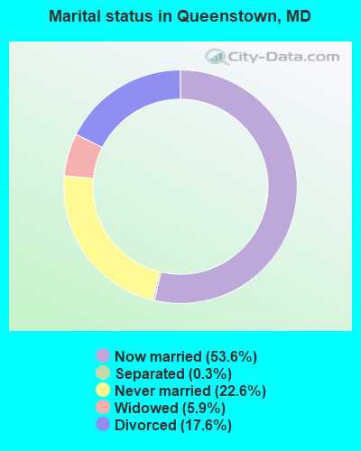
- Never married: 22.6%
- Now married: 53.6%
- Separated: 0.3%
- Widowed: 5.9%
- Divorced: 17.6%
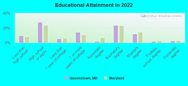
For population 25 years and over in Queenstown:
- High school or higher: 90.0%
- Bachelor's degree or higher: 38.8%
- Graduate or professional degree: 16.5%
- Unemployed: 1.4%
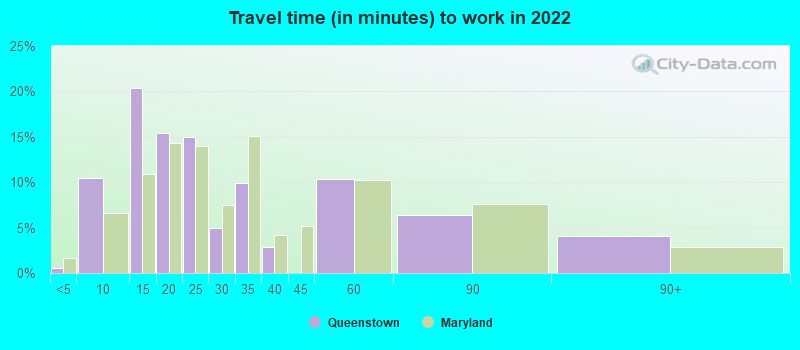
- Mean travel time to work (commute): 27.5 minutes
| Here: | 15.8 |
| Maryland average: | 12.7 |
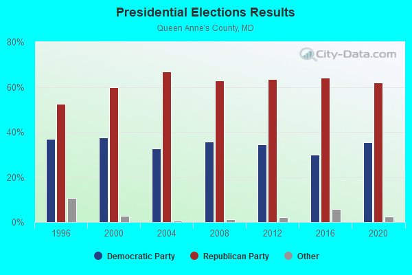
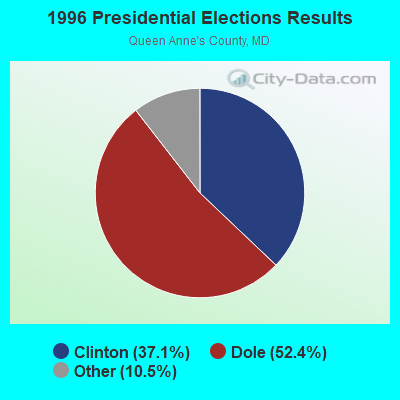
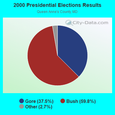
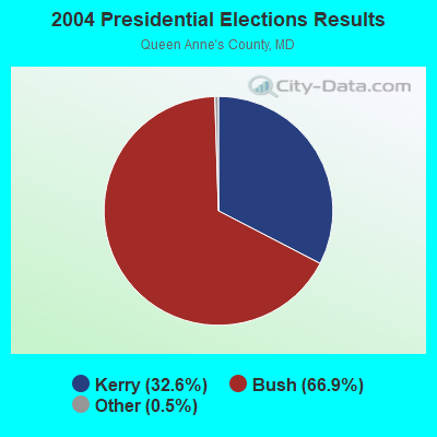
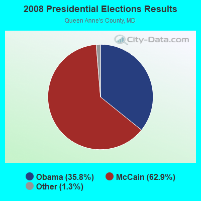
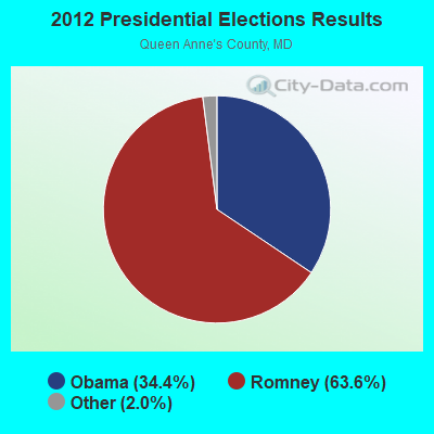
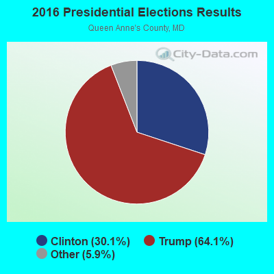

Graphs represent county-level data. Detailed 2008 Election Results
Religion statistics for Queenstown, MD (based on Queen Anne's County data)
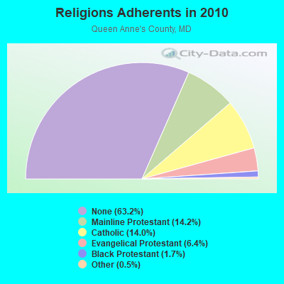
| Religion | Adherents | Congregations |
|---|---|---|
| Mainline Protestant | 6,786 | 31 |
| Catholic | 6,673 | 3 |
| Evangelical Protestant | 3,072 | 21 |
| Black Protestant | 805 | 5 |
| Other | 230 | 2 |
| None | 30,232 | - |
Food Environment Statistics:
| Queen Anne's County: | 2.36 / 10,000 pop. |
| State: | 1.96 / 10,000 pop. |
| This county: | 0.86 / 10,000 pop. |
| State: | 1.22 / 10,000 pop. |
| This county: | 4.30 / 10,000 pop. |
| State: | 2.05 / 10,000 pop. |
| This county: | 6.02 / 10,000 pop. |
| Maryland: | 5.40 / 10,000 pop. |
| This county: | 7.8% |
| Maryland: | 9.1% |
| This county: | 24.4% |
| Maryland: | 26.7% |
| Queen Anne's County: | 13.3% |
| Maryland: | 15.5% |
Health and Nutrition:
| This city: | 45.7% |
| Maryland: | 50.1% |
| Queenstown: | 39.5% |
| State: | 47.6% |
| Queenstown: | 28.5 |
| Maryland: | 28.8 |
| Queenstown: | 23.9% |
| Maryland: | 20.0% |
| Queenstown: | 8.6% |
| State: | 11.3% |
| Here: | 6.8 |
| Maryland: | 6.8 |
| Queenstown: | 33.6% |
| Maryland: | 34.1% |
| Queenstown: | 50.8% |
| Maryland: | 56.5% |
| Queenstown: | 75.9% |
| Maryland: | 80.5% |
More about Health and Nutrition of Queenstown, MD Residents
| Local government employment and payroll (March 2022) | |||||
| Function | Full-time employees | Monthly full-time payroll | Average yearly full-time wage | Part-time employees | Monthly part-time payroll |
|---|---|---|---|---|---|
| Other Government Administration | 2 | $9,340 | $56,040 | 0 | $0 |
| Other and Unallocable | 2 | $6,154 | $36,924 | 0 | $0 |
| Totals for Government | 4 | $15,493 | $46,479 | 0 | $0 |
Queenstown government finances - Expenditure in 2017 (per resident):
- Current Operations - Water Utilities: $829,000 ($1118.76)
Central Staff Services: $199,000 ($268.56)
Regular Highways: $165,000 ($222.67)
Solid Waste Management: $71,000 ($95.82)
Judicial and Legal Services: $39,000 ($52.63)
General - Other: $33,000 ($44.53)
Local Fire Protection: $14,000 ($18.89)
General Public Buildings: $7,000 ($9.45)
Financial Administration: $7,000 ($9.45)
Parks and Recreation: $3,000 ($4.05)
- General - Interest on Debt: $129,000 ($174.09)
- Other Capital Outlay - Regular Highways: $33,000 ($44.53)
Central Staff Services: $5,000 ($6.75)
- Total Salaries and Wages: $167,000 ($225.37)
Queenstown government finances - Revenue in 2017 (per resident):
- Charges - Sewerage: $356,000 ($480.43)
- Federal Intergovernmental - Sewerage: $416,000 ($561.40)
- Local Intergovernmental - Highways: $111,000 ($149.80)
Other: $5,000 ($6.75)
- Miscellaneous - General Revenue - Other: $118,000 ($159.24)
Interest Earnings: $7,000 ($9.45)
Rents: $6,000 ($8.10)
- Revenue - Water Utilities: $104,000 ($140.35)
- State Intergovernmental - Highways: $26,000 ($35.09)
Sewerage: $21,000 ($28.34)
Other: $1,000 ($1.35)
- Tax - Property: $404,000 ($545.21)
Individual Income: $115,000 ($155.20)
Occupation and Business License - Other: $23,000 ($31.04)
Other License: $8,000 ($10.80)
Public Utility License: $4,000 ($5.40)
Queenstown government finances - Debt in 2017 (per resident):
- Long Term Debt - Outstanding Unspecified Public Purpose: $5,698,000 ($7689.61)
Beginning Outstanding - Unspecified Public Purpose: $5,469,000 ($7380.57)
Issue, Unspecified Public Purpose: $350,000 ($472.33)
Retired Unspecified Public Purpose: $122,000 ($164.64)
Queenstown government finances - Cash and Securities in 2017 (per resident):
- Bond Funds - Cash and Securities: $190,000 ($256.41)
- Other Funds - Cash and Securities: $1,858,000 ($2507.42)
| Businesses in Queenstown, MD | ||||
| Name | Count | Name | Count | |
|---|---|---|---|---|
| 7-Eleven | 1 | Gymboree | 1 | |
| Aeropostale | 1 | IZOD | 1 | |
| Banana Republic | 1 | J.Crew | 1 | |
| Bath & Body Works | 1 | Jones New York | 1 | |
| Brooks Brothers | 1 | Juicy Couture | 1 | |
| Chico's | 1 | MasterBrand Cabinets | 3 | |
| Clarks | 1 | Old Navy | 1 | |
| DressBarn | 1 | Pac Sun | 1 | |
| Dressbarn | 1 | Subway | 2 | |
| Eddie Bauer | 1 | Talbots | 1 | |
| Famous Footwear | 1 | The Room Place | 1 | |
| FedEx | 1 | UPS | 1 | |
| Gap | 1 | |||
Strongest AM radio stations in Queenstown:
- WBIS (1190 AM; 50 kW; ANNAPOLIS, MD; Owner: NATIONS RADIO, LLC)
- WWLG (1370 AM; 50 kW; BALTIMORE, MD; Owner: M-10 BROADCASTING, INC.)
- WCBM (680 AM; 50 kW; BALTIMORE, MD; Owner: WCBM MARYLAND, INC.)
- WTEM (980 AM; 50 kW; WASHINGTON, DC; Owner: AMFM RADIO LICENSES, L.L.C.)
- WBAL (1090 AM; 50 kW; BALTIMORE, MD; Owner: HEARST RADIO, INC.)
- WWGB (1030 AM; daytime; 50 kW; INDIAN HEAD, MD; Owner: GOOD BODY MEDIA, LLC)
- WPGC (1580 AM; 50 kW; MORNINGSIDE, MD; Owner: INFINITY WPGC(AM), INC.)
- WGOP (700 AM; daytime; 25 kW; WALKERSVILLE, MD; Owner: BIRACH BROADCASTING CORPORATION)
- WTOP (1500 AM; 50 kW; WASHINGTON, DC; Owner: BONNEVILLE HOLDING COMPANY)
- WMET (1150 AM; 50 kW; GAITHERSBURG, MD; Owner: BELTWAY ACQUISITION CORPORATION)
- WVCH (740 AM; 50 kW; CHESTER, PA; Owner: WVCH COMMUNICATIONS, INC.)
- WNAV (1430 AM; 5 kW; ANNAPOLIS, MD; Owner: SAJAK BROADCASTING CORP.)
- WPEN (950 AM; 50 kW; PHILADELPHIA, PA; Owner: GREATER PHILADELPHIA RADIO, INC.)
Strongest FM radio stations in Queenstown:
- WRNR-FM (103.1 FM; GRASONVILLE, MD; Owner: EMPIRE BROADCASTING SYSTEM, INC.)
- WWMX (106.5 FM; BALTIMORE, MD; Owner: INFINITY RADIO OPERATIONS INC.)
- WIYY (97.9 FM; BALTIMORE, MD; Owner: HEARST RADIO, INC.)
- WLIF (101.9 FM; BALTIMORE, MD; Owner: INFINITY WLIF, INC.)
- WPOC (93.1 FM; BALTIMORE, MD; Owner: CITICASTERS LICENSES, L.P.)
- WCEI-FM (96.7 FM; EASTON, MD; Owner: FIRST MEDIA RADIO, LLC)
- WFSI (107.9 FM; ANNAPOLIS, MD; Owner: FAMILY STATIONS, INC.)
- WBZS-FM (92.7 FM; PRINCE FREDERICK, MD; Owner: MEGA COMMUNICATIONS OF PRINCE FREDERICK LICENSEE, LLC)
- WAAI (100.9 FM; HURLOCK, MD; Owner: MTS BROADCASTING, L.C.)
- WTDK (107.1 FM; FEDERALSBURG, MD; Owner: MTS BROADCASTING, L.C.)
- WXYV (105.7 FM; CATONSVILLE, MD; Owner: INFINITY RADIO OPERATIONS INC.)
- WINX-FM (94.3 FM; CAMBRIDGE, MD; Owner: CWA BROADCASTING, INC.)
TV broadcast stations around Queenstown:
- WMPT (Channel 22; ANNAPOLIS, MD; Owner: MARYLAND PUBLIC BROADCASTING COMMISSION)
- WBAL-TV (Channel 11; BALTIMORE, MD; Owner: WBAL HEARST-ARGYLE TV, INC. (CA CORP.))
- WMAR-TV (Channel 2; BALTIMORE, MD; Owner: SCRIPPS HOWARD BROADCASTING COMPANY)
- WBFF (Channel 45; BALTIMORE, MD; Owner: CHESAPEAKE TELEVISION LICENSEE, LLC)
- WNUV (Channel 54; BALTIMORE, MD; Owner: BALTIMORE (WNUV-TV) LICENSEE, INC.)
- WJZ-TV (Channel 13; BALTIMORE, MD; Owner: VIACOM INC.)
- W61BY (Channel 61; ANNAPOLIS, MD; Owner: ANNAPOLIS BROADCASTING COMPANY, INC.)
- W63BP (Channel 63; ANNAPOLIS, MD; Owner: ANNAPOLIS BROADCASTING COMPANY, INC.)
- WTSD-CA (Channel 14; WILMINGTON, DE; Owner: PRIORITY COMMUNICATIONS MINISTRIES, INC.)
- WMDT (Channel 47; SALISBURY, MD; Owner: DELMARVA BROADCAST SERVICE GENERAL PARTNERSHIP)
- WUTB (Channel 24; BALTIMORE, MD; Owner: FOX TELEVISION STATIONS, INC.)
- WMPB (Channel 67; BALTIMORE, MD; Owner: MARYLAND PUBLIC BROADCASTING COMMISSION)
- WBOC-TV (Channel 16; SALISBURY, MD; Owner: WBOC, INC.)
- Queenstown, Maryland
- Fatal accident count32
- Vehicles involved in fatal accidents48
- Fatal accidents involving drunk persons:11
- Fatalities32
- Persons involved in fatal accidents75
- Pedestrians involved in fatal accidents2
- Maryland average
- Fatal accident count11108
- Vehicles involved in fatal accidents16648
- Fatal accidents involving drunk persons3873
- Fatalities12217
- Persons involved in fatal accidents28809
- Pedestrians involved in fatal accidents828
- National Bridge Inventory (NBI) Statistics
- 8Number of bridges
- 62ft / 18.6mTotal length
- $617,000Total costs
- 299,895Total average daily traffic
- 24,978Total average daily truck traffic
FCC Registered Antenna Towers:
10 (See the full list of FCC Registered Antenna Towers in Queenstown)FCC Registered Broadcast Land Mobile Towers:
6- Us 50 1 Mi E Of Us 301 (Lat: 38.982333 Lon: -76.160222), Type: Pole, Structure height: 5 m, Overall height: 8 m, Call Sign: WNQA289,
Assigned Frequencies: 0.53000 MHz, 1.61000 MHz, 1.63000 MHz, Grant Date: 09/12/2023, Expiration Date: 12/09/2033, Certifier: Gerrit Veenhof, Registrant: Mdot State Highway Administration, 5901 Baltimore National Pike, Catonsville, MD 21228, Phone: (410) 455-8330, Fax: (410) 744-4716, Email:
- Lat: 38.982500 Lon: -76.159167, Call Sign: WPSS701,
Assigned Frequencies: 461.337 MHz, 464.562 MHz, 466.337 MHz, 469.562 MHz, Grant Date: 07/25/2001, Expiration Date: 07/25/2011, Cancellation Date: 09/24/2011, Certifier: Mark Olson, Registrant: Advanced Wireless Communications, Northfield, MN 55057, Phone: (507) 645-5852, Fax: (507) 645-5905
- Us 50 Wb @ Chesapeake Village Shopping Center (Lat: 38.981694 Lon: -76.161417), Type: Upole, Structure height: 0 m, Overall height: 15 m, Call Sign: WQNS664,
Assigned Frequencies: 1.61000 MHz, Grant Date: 05/07/2021, Expiration Date: 05/11/2031, Certifier: Robert Jordan, Registrant: Mdta, 300 Authority Drive, Baltimore, MD 21222, Phone: (410) 537-7852, Email:
- Lat: 38.989611 Lon: -76.168444, Call Sign: WQNZ910,
Assigned Frequencies: 456.762 MHz, 457.312 MHz, 457.287 MHz, 451.825 MHz, 452.012 MHz, 452.350 MHz, 452.437 MHz, 461.175 MHz, Grant Date: 07/20/2011, Expiration Date: 07/20/2021, Cancellation Date: 10/09/2021, Certifier: John Anderes, Registrant: Teltronic, Inc., 2016 Windsor Dr, Salisbury, MD 21801, Phone: (410) 912-1479, Fax: (240) 581-5719, Email:
- Lat: 38.963417 Lon: -76.126361, Call Sign: WQSC352,
Assigned Frequencies: 451.287 MHz, 451.387 MHz, 451.662 MHz, 456.400 MHz, 456.875 MHz, Grant Date: 08/29/2013, Expiration Date: 08/29/2023, Cancellation Date: 11/04/2023, Certifier: Kurt Wittman, Registrant: Scott Communications, Inc., 2888 Bethlehem Pike, Hatfield, PA 19440, Phone: (215) 997-9500, Fax: (215) 822-8713, Email:
- Lat: 38.961889 Lon: -76.139889, Call Sign: WQUD652,
Assigned Frequencies: 468.312 MHz, 456.237 MHz, 456.412 MHz, 457.062 MHz, 457.662 MHz, Grant Date: 06/10/2014, Expiration Date: 06/10/2024, Certifier: Chris Idanec, Registrant: Integrated Communication Systems, 1417 Sadler Road #272, Amelia Island, FL 32034, Phone: (904) 556-6446, Email:
FCC Registered Microwave Towers:
4- DC03XC492, Friels Rd (0.25 Mi W From Main St And Rte 18 Intersection) (Lat: 38.984167 Lon: -76.156556), Type: Tank, Structure height: 42.7 m, Overall height: 43.9 m, Call Sign: WQPU931,
Assigned Frequencies: 11385.0 MHz, 11385.0 MHz, 11385.0 MHz, 11385.0 MHz, 11385.0 MHz, 11385.0 MHz, 11385.0 MHz, 10815.0 MHz, 10815.0 MHz, 10815.0 MHz, Grant Date: 08/21/2012, Expiration Date: 08/21/2022, Cancellation Date: 08/15/2022, Certifier: David Werblow, Registrant: Dla Piper LLP, 500 8th Street, Nw, Washington, DC 20004, Phone: (202) 799-4216, Fax: (202) 799-5616, Email:
- DC03XC617, Foremans Landing Rd (Wye Mills 2) (019051) (Lat: 38.956167 Lon: -76.092889), Type: Gtower, Structure height: 138.3 m, Overall height: 139 m, Call Sign: WQPV366,
Assigned Frequencies: 10775.0 MHz, 10855.0 MHz, 10775.0 MHz, 10855.0 MHz, 10775.0 MHz, 10855.0 MHz, Grant Date: 10/12/2022, Expiration Date: 08/23/2032, Certifier: David Werblow, Registrant: T-Mobile Usa, Inc., 12920 Se 38th St, Bellevue, WA 98006, Phone: (425) 383-8401, Fax: (425) 383-4040, Email:
- WA54XC560, 5630 Main St (Rt18) (Lat: 38.965111 Lon: -76.181056), Type: Pole, Structure height: 51.2 m, Overall height: 54.3 m, Call Sign: WQPV520,
Assigned Frequencies: 11305.0 MHz, 11305.0 MHz, 11305.0 MHz, Grant Date: 08/23/2012, Expiration Date: 08/23/2022, Cancellation Date: 08/15/2022, Certifier: David Werblow, Registrant: Dla Piper LLP, 500 8th Street, Nw, Washington, DC 20004, Phone: (202) 799-4216, Fax: (202) 799-5616, Email:
- WYE MILLS, Foremans Landing Rd (Wye Mills 2) (019051) (Lat: 38.956167 Lon: -76.092889), Type: Gtower, Structure height: 138.3 m, Overall height: 139 m, Call Sign: WQXQ239,
Assigned Frequencies: 10735.0 MHz, 10735.0 MHz, 10735.0 MHz, 10735.0 MHz, 10735.0 MHz, 10735.0 MHz, 10735.0 MHz, 10735.0 MHz, 11175.0 MHz, 11175.0 MHz... (+30 more), Grant Date: 05/05/2016, Expiration Date: 05/05/2026, Certifier: Jim F Connor, Registrant: Intelpath, Hinsdale, IL 60522, Phone: (312) 841-9188, Email:
FCC Registered Amateur Radio Licenses:
23 (See the full list of FCC Registered Amateur Radio Licenses in Queenstown)FAA Registered Aircraft:
10 (See the full list of FAA Registered Aircraft in Queenstown)| Home Mortgage Disclosure Act Aggregated Statistics For Year 2009 (Based on 1 partial tract) | ||
| C) Refinancings | ||
|---|---|---|
| Number | Average Value | |
| LOANS ORIGINATED | 2 | $259,790 |
| APPLICATIONS APPROVED, NOT ACCEPTED | 0 | $0 |
| APPLICATIONS DENIED | 1 | $229,830 |
| APPLICATIONS WITHDRAWN | 0 | $0 |
| FILES CLOSED FOR INCOMPLETENESS | 0 | $0 |
Detailed HMDA statistics for the following Tracts: 8106.00
2002 - 2018 National Fire Incident Reporting System (NFIRS) incidents
- Fire incident types reported to NFIRS in Queenstown, MD
- 20248.9%Structure Fires
- 13232.0%Outside Fires
- 6114.8%Mobile Property/Vehicle Fires
- 184.4%Other
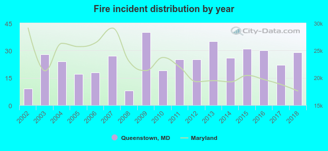 According to the data from the years 2002 - 2018 the average number of fire incidents per year is 24. The highest number of fires - 40 took place in 2009, and the least - 8 in 2008. The data has a rising trend.
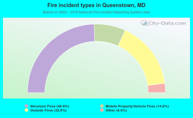 When looking into fire subcategories, the most reports belonged to: Structure Fires (48.9%), and Outside Fires (32.0%).
| Most common first names in Queenstown, MD among deceased individuals | ||
| Name | Count | Lived (average) |
|---|---|---|
| James | 31 | 75.1 years |
| William | 29 | 77.6 years |
| John | 28 | 75.6 years |
| Mary | 23 | 80.4 years |
| Charles | 21 | 79.4 years |
| Margaret | 18 | 84.5 years |
| George | 12 | 70.6 years |
| Elizabeth | 12 | 85.2 years |
| Helen | 11 | 82.7 years |
| Thomas | 9 | 78.3 years |
| Most common last names in Queenstown, MD among deceased individuals | ||
| Last name | Count | Lived (average) |
|---|---|---|
| Smith | 15 | 73.5 years |
| Johnson | 10 | 78.3 years |
| Wilson | 8 | 76.5 years |
| Griffin | 7 | 78.3 years |
| Comegys | 6 | 73.3 years |
| Miller | 6 | 70.2 years |
| Bryan | 6 | 84.3 years |
| Thompson | 6 | 67.2 years |
| Baker | 6 | 75.8 years |
| Morris | 5 | 72.2 years |
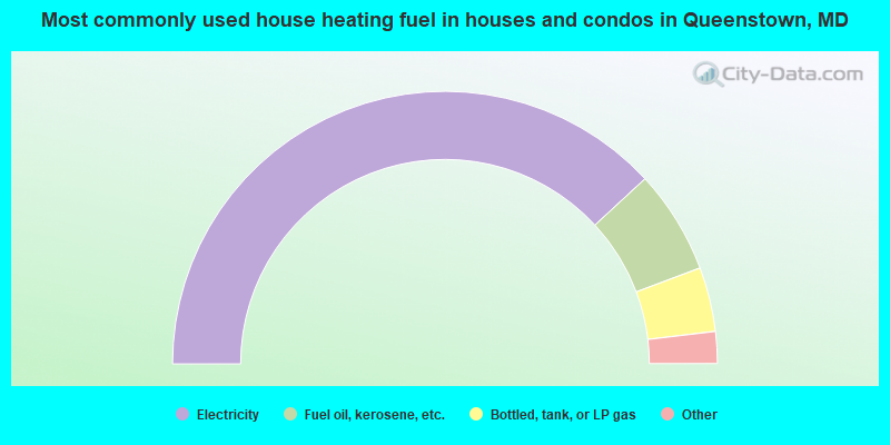
- 76.8%Electricity
- 12.4%Fuel oil, kerosene, etc.
- 7.7%Bottled, tank, or LP gas
- 2.1%Wood
- 1.0%Other fuel
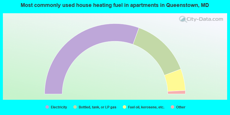
- 62.0%Electricity
- 27.8%Bottled, tank, or LP gas
- 10.1%Fuel oil, kerosene, etc.
Queenstown compared to Maryland state average:
- Unemployed percentage significantly below state average.
- Black race population percentage below state average.
- Hispanic race population percentage significantly above state average.
- Median age above state average.
- Length of stay since moving in significantly above state average.
Queenstown on our top lists:
- #27 on the list of "Top 101 cities with the most residents born in Hungary (population 500+)"
- #71 on the list of "Top 101 cities with the most residents born in Trinidad and Tobago (population 500+)"
- #60 on the list of "Top 101 counties with the highest percentage of residents that drank alcohol in the past 30 days"
- #63 on the list of "Top 101 counties with the highest percentage of residents that visited a dentist within the past year"
- #72 on the list of "Top 101 counties with the highest percentage of residents that smoked 100+ cigarettes in their lives"

|
|
Total of 37 patent applications in 2008-2024.