Red Rock, New Mexico
Submit your own pictures of this place and show them to the world
- OSM Map
- General Map
- Google Map
- MSN Map

| Males: 12,022 | |
| Females: 12,443 |
| Median resident age: | 24.8 years |
| New Mexico median age: | 34.6 years |
Zip code: 87316
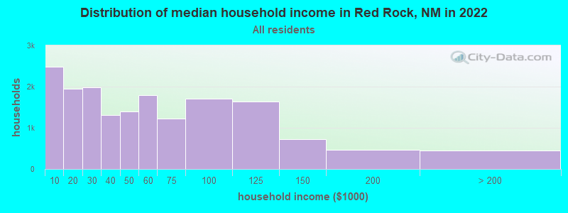
| Red Rock: | $36,699 |
| NM: | $59,726 |
Estimated per capita income in 2022: $15,426 (it was $7,830 in 2000)
Red Rock CCD income, earnings, and wages data
Estimated median house or condo value in 2022: $59,263 (it was $31,900 in 2000)
| Red Rock: | $59,263 |
| NM: | $243,100 |
Mean prices in 2022: all housing units: $150,675; detached houses: $171,344; townhouses or other attached units: $157,130; in 2-unit structures: $99,669; mobile homes: $111,793
Detailed information about poverty and poor residents in Red Rock, NM
Compare current foreclosures near Red Rock, NM:
| Photo | Address | Area | Beds / Baths | Price | Details |
|---|---|---|---|---|---|

|
#1
E Maloney Ave
Gallup, NM 87301
|
1,485 sq. feet
|
1 baths 3 beds |
$49,900
|
show details |

|
#2
Sweetwater Road
Fort Wingate, NM 87316
|
- sq. feet
|
- baths - beds |
show details | |

|
#3
Maya Dr
Gallup, NM 87301
|
- sq. feet
|
- baths - beds |
show details | |

|
#4
Helena Dr
Gallup, NM 87301
|
- sq. feet
|
- baths - beds |
show details | |

|
#5
S Strong Dr
Gallup, NM 87301
|
- sq. feet
|
- baths - beds |
show details | |

|
#6
W Jefferson St
Gallup, NM 87301
|
- sq. feet
|
- baths - beds |
show details | |

|
#7
Boyd Ave
Gallup, NM 87301
|
- sq. feet
|
- baths - beds |
show details | |

|
#8
Burke Dr
Gallup, NM 87301
|
- sq. feet
|
- baths - beds |
show details | |

|
#9
N Third St
Gallup, NM 87301
|
- sq. feet
|
- baths - beds |
show details | |

|
#10
W Wilson Ave
Gallup, NM 87301
|
- sq. feet
|
- baths - beds |
show details |
| Photo | Address | Area | Beds / Baths | Price | Details |
|---|---|---|---|---|---|

|
Check over 1 million property listings on Foreclosure.com!
|
browse all offers | |||
| Photo | Address | Area | Beds / Baths | Price | Details |
|---|

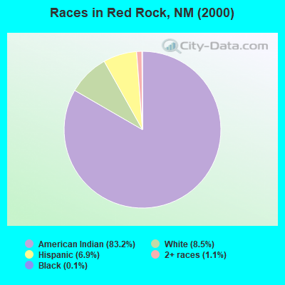
- 21,71883.2%American Indian alone
- 2,2258.5%White alone
- 1,8096.9%Hispanic
- 2951.1%Two or more races
- 330.1%Black alone
- 160.06%Asian alone
- 80.03%Native Hawaiian and Other
Pacific Islander alone - 20.01%Other race alone
Races in Red Rock detailed stats: ancestries, foreign born residents, place of birth
 Recent articles from our blog. Our writers, many of them Ph.D. graduates or candidates, create easy-to-read articles on a wide variety of topics.

Current Local Time: MST time zone
Elevation: 6755 feet
Land area: 1760.9 square miles.
Population density: 14 people per square mile (very low).
| Red Rock CCD: | 0.7% ($235) |
| New Mexico: | 0.7% ($699) |
Nearest city with pop. 50,000+: Rio Rancho, NM  (106.0 miles , pop. 51,765).
Nearest city with pop. 200,000+: Albuquerque, NM (111.5 miles , pop. 448,607).
Nearest city with pop. 1,000,000+: Phoenix, AZ (242.0 miles , pop. 1,321,045).
Nearest cities:
), ), ), ), ), Latitude: 35.46 N, Longitude: 108.54 W
Area code commonly used in this area: 505

| Here: | 4.7% |
| New Mexico: | 3.6% |
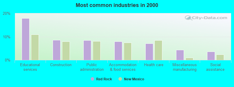
- Educational services (17.9%)
- Construction (8.5%)
- Public administration (8.4%)
- Accommodation & food services (8.0%)
- Health care (7.1%)
- Miscellaneous manufacturing (4.4%)
- Social assistance (3.6%)
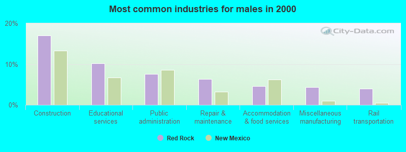
- Construction (17.0%)
- Educational services (10.2%)
- Public administration (7.6%)
- Repair & maintenance (6.3%)
- Accommodation & food services (4.6%)
- Miscellaneous manufacturing (4.4%)
- Rail transportation (4.0%)
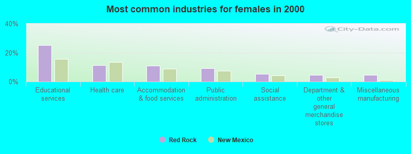
- Educational services (25.3%)
- Health care (11.4%)
- Accommodation & food services (11.1%)
- Public administration (9.2%)
- Social assistance (5.3%)
- Department & other general merchandise stores (4.8%)
- Miscellaneous manufacturing (4.4%)
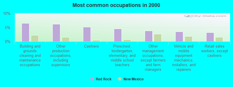
- Building and grounds cleaning and maintenance occupations (6.5%)
- Other production occupations, including supervisors (6.1%)
- Cashiers (5.2%)
- Preschool, kindergarten, elementary, and middle school teachers (4.6%)
- Other management occupations, except farmers and farm managers (3.8%)
- Vehicle and mobile equipment mechanics, installers, and repairers (3.5%)
- Retail sales workers, except cashiers (3.2%)
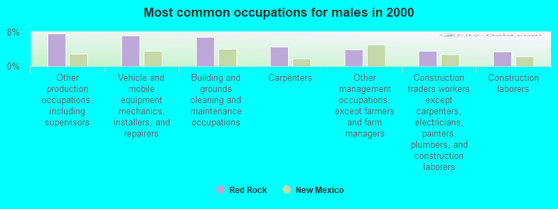
- Other production occupations, including supervisors (7.7%)
- Vehicle and mobile equipment mechanics, installers, and repairers (7.2%)
- Building and grounds cleaning and maintenance occupations (6.9%)
- Carpenters (4.6%)
- Other management occupations, except farmers and farm managers (4.0%)
- Construction traders workers except carpenters, electricians, painters, plumbers, and construction laborers (3.6%)
- Construction laborers (3.5%)
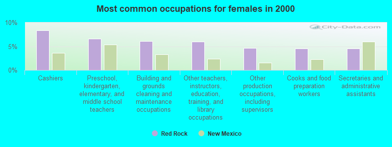
- Cashiers (8.4%)
- Preschool, kindergarten, elementary, and middle school teachers (6.6%)
- Building and grounds cleaning and maintenance occupations (6.1%)
- Other teachers, instructors, education, training, and library occupations (5.9%)
- Other production occupations, including supervisors (4.7%)
- Cooks and food preparation workers (4.6%)
- Secretaries and administrative assistants (4.5%)
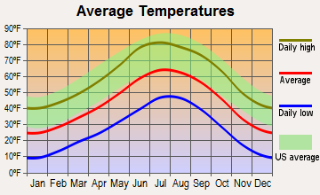
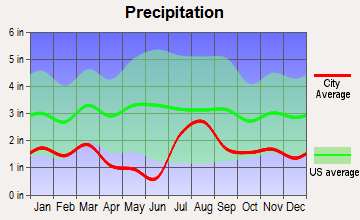
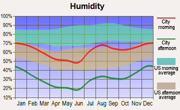
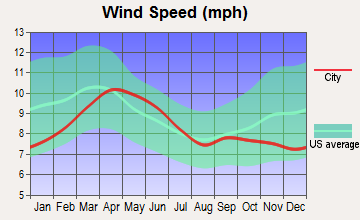
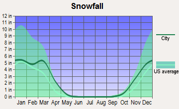
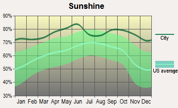
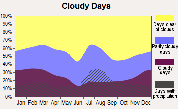
Average climate in Red Rock, New Mexico
Based on data reported by over 4,000 weather stations
Earthquake activity:
Red Rock-area historical earthquake activity is significantly above New Mexico state average. It is 1118% greater than the overall U.S. average.On 6/28/1992 at 11:57:34, a magnitude 7.6 (6.2 MB, 7.6 MS, 7.3 MW, Depth: 0.7 mi, Class: Major, Intensity: VIII - XII) earthquake occurred 462.3 miles away from the city center, causing 3 deaths (1 shaking deaths, 2 other deaths) and 400 injuries, causing $100,000,000 total damage and $40,000,000 insured losses
On 10/16/1999 at 09:46:44, a magnitude 7.4 (6.3 MB, 7.4 MS, 7.2 MW, 7.3 ML) earthquake occurred 452.2 miles away from the city center
On 5/19/1940 at 04:36:40, a magnitude 7.2 (7.2 UK) earthquake occurred 437.1 miles away from Red Rock center, causing $33,000,000 total damage
On 12/31/1934 at 18:45:56, a magnitude 7.1 (7.1 UK) earthquake occurred 456.1 miles away from the city center
On 10/15/1979 at 23:16:54, a magnitude 7.0 (5.7 MB, 6.9 MS, 7.0 ML, 6.4 MW) earthquake occurred 445.7 miles away from Red Rock center
On 4/29/1993 at 08:21:00, a magnitude 5.5 (5.5 MB, 5.0 MS, 5.3 MW, Depth: 6.2 mi, Class: Moderate, Intensity: VI - VII) earthquake occurred 201.4 miles away from Red Rock center
Magnitude types: body-wave magnitude (MB), local magnitude (ML), surface-wave magnitude (MS), moment magnitude (MW)
Natural disasters:
The number of natural disasters in McKinley County (10) is smaller than the US average (15).Major Disasters (Presidential) Declared: 7
Emergencies Declared: 2
Causes of natural disasters: Floods: 6, Storms: 6, Fires: 2, Hurricane: 1, Mudslide: 1, Snow: 1, Other: 1 (Note: some incidents may be assigned to more than one category).
Hospitals and medical centers near Red Rock:
- RED ROCKS CARE CENTER (Nursing Home, about 9 miles away; GALLUP, NM)
- RED ROCKS DIALYSIS- GALLUP (Dialysis Facility, about 12 miles away; GALLUP, NM)
- GALLUP INDIAN MEDICAL CENTER Acute Care Hospitals (about 12 miles away; GALLUP, NM)
- MCKINLEY CARE AND REHABILITATION CENTER (Nursing Home, about 12 miles away; GALLUP, NM)
Colleges/universities with over 2000 students nearest to Red Rock:
- San Juan College (about 93 miles; Farmington, NM; Full-time enrollment: 5,112)
- Central New Mexico Community College (about 112 miles; Albuquerque, NM; FT enrollment: 19,398)
- University of New Mexico-Main Campus (about 112 miles; Albuquerque, NM; FT enrollment: 23,042)
- University of Phoenix-Albuquerque Campus (about 112 miles; Albuquerque, NM; FT enrollment: 2,335)
- Fort Lewis College (about 131 miles; Durango, CO; FT enrollment: 3,631)
- Santa Fe Community College (about 143 miles; Santa Fe, NM; FT enrollment: 3,047)
- Coconino Community College (about 177 miles; Flagstaff, AZ; FT enrollment: 2,090)
Points of interest:
Notable locations in Red Rock: Quaking Aspen Campground (A), Radosevich Ranch (B), Rancho Del Puerto (C), Black Hat (D), Dewey (E), Rico Ranch (F), Rock Spring Ranch (G), Stallings (H), Stinkwater Well (I), Tom Ranch (J), Tse Bonita Trading Post (K), Ralph Bond Ranch (L), Clo-Chew-Tah Ranch (M), Williams Acres (N), Six A Ranch (O), Williams Acres (P), Rico Ranch (Q), Springstead Trading Post (R), Zuni Indian Tribal Lands (S), Ramah Indian Tribal Lands (T). Display/hide their locations on the map
Shopping Center: Pinon Placita Shopping Center (1). Display/hide its location on the map
Churches in Red Rock include: Seventh Day Adventist Church (A), Full Gospel Assemmbly of God Church (B), West Mesa Assembly of God Church (C), Pinedale Indian Assebly of God Church (D), Westminister United Presbyterian Church (E), First United Methodist Church (F), United Pentecostal Church (G), Spanish Assembly of God Church (H), Indian Assembly of God Church (I). Display/hide their locations on the map
Cemeteries: Pinehaven Cemetery (1), Sunset Memorial Gardens (2), McGaffey Cemetery (3), Hillcrest Cemetery (4), Ramah Cemetery (5), Torreon Cemetery (6). Display/hide their locations on the map
Lakes and reservoirs: Laguna del Monte (A), Natural Lake (B), Togeye Lake (C), Lost Lake (D), Samson Lake (E), Brennan Tank (F), Section Tank (G), Prewitt Lake (H). Display/hide their locations on the map
Streams, rivers, and creeks: Agua Remora (A), Banana Ridge Wash (B), Black Ridge Wash (C), Burned Death Wash (D), Burned Through the Rock Wash (E), Coal Mine Wash (F), Disappearing Spring Wash (G), Dragon Wash (H), Dubois Wash (I). Display/hide their locations on the map
Parks in Red Rock include: Red Rock State Park (1), Continental Divide Historical Marker (2), Kiwanis Park (3), Fort Defiance Historical Marker (4), Red Rocks Historical Marker (5), Gallup Historical Marker (6), Chaco Cliffs Historical Marker (7), McGaffey Camp and Picnic Grounds (8), Fort Wingate Historical Marker (9). Display/hide their locations on the map
| This place: | 3.4 people |
| New Mexico: | 2.5 people |
| This place: | 75.7% |
| Whole state: | 65.5% |
| This place: | 8.7% |
| Whole state: | 8.2% |
Likely homosexual households (counted as self-reported same-sex unmarried-partner households)
- Lesbian couples: 0.2% of all households
- Gay men: 0.3% of all households
| This place: | 40.4% |
| Whole state: | 18.4% |
| This place: | 22.6% |
| Whole state: | 7.8% |
For population 15 years and over in Red Rock:
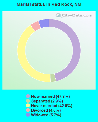
- Never married: 42.0%
- Now married: 47.8%
- Separated: 2.9%
- Widowed: 5.7%
- Divorced: 4.6%
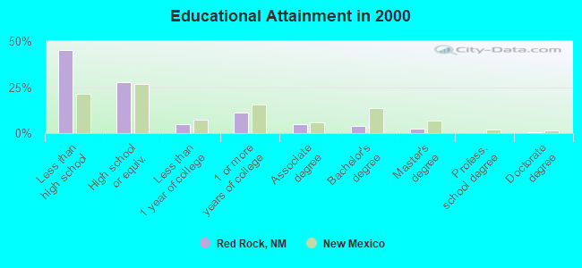
For population 25 years and over in Red Rock:
- High school or higher: 55.1%
- Bachelor's degree or higher: 7.0%
- Graduate or professional degree: 3.0%
- Unemployed: 22.7%
- Mean travel time to work (commute): 29.8 minutes
| Here: | 23.2 |
| New Mexico average: | 14.5 |
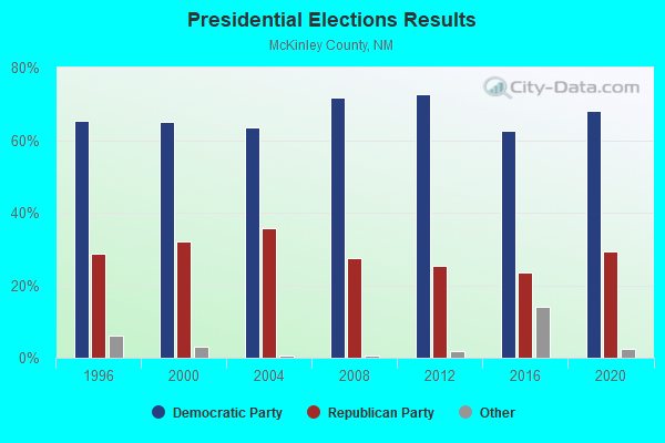
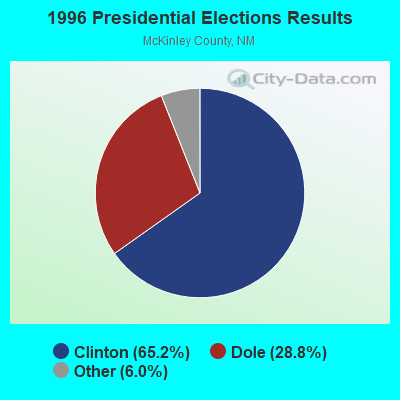
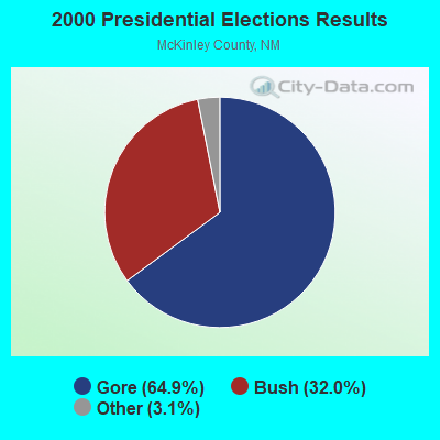
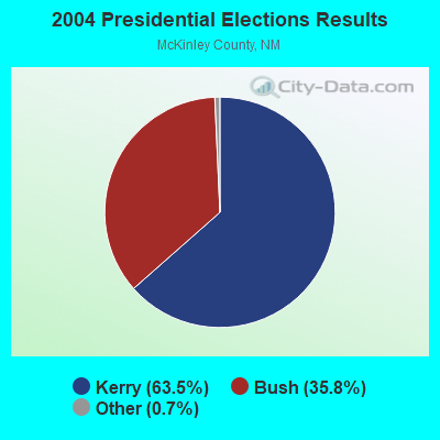
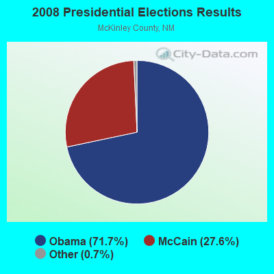
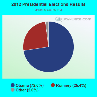
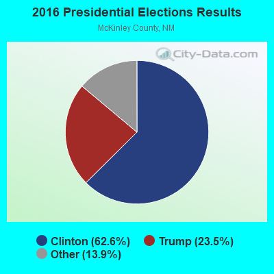
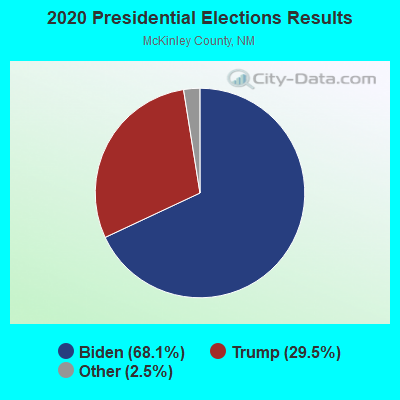
Graphs represent county-level data. Detailed 2008 Election Results
Religion statistics for Red Rock, NM (based on McKinley County data)
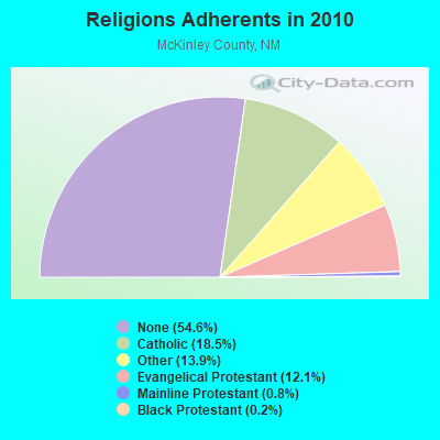
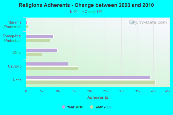
| Religion | Adherents | Congregations |
|---|---|---|
| Catholic | 13,200 | 12 |
| Other | 9,910 | 15 |
| Evangelical Protestant | 8,675 | 73 |
| Mainline Protestant | 574 | 4 |
| Black Protestant | 131 | 1 |
| None | 39,002 | - |
Food Environment Statistics:
| This county: | 1.86 / 10,000 pop. |
| New Mexico: | 1.44 / 10,000 pop. |
| Here: | 0.14 / 10,000 pop. |
| New Mexico: | 0.21 / 10,000 pop. |
| This county: | 0.29 / 10,000 pop. |
| New Mexico: | 0.32 / 10,000 pop. |
| McKinley County: | 6.86 / 10,000 pop. |
| New Mexico: | 4.06 / 10,000 pop. |
| This county: | 6.14 / 10,000 pop. |
| State: | 7.12 / 10,000 pop. |
| McKinley County: | 11.4% |
| State: | 6.4% |
| McKinley County: | 32.8% |
| State: | 22.1% |
| Here: | 12.0% |
| State: | 11.5% |
Strongest AM radio stations in Red Rock:
- KHAC (880 AM; 43 kW; TSE BONITO, NM; Owner: WESTERN INDIAN MINISTRIES, INC.)
- KTNN (660 AM; 50 kW; WINDOW ROCK, AZ; Owner: THE NAVAJO NATION)
- KGAK (1330 AM; 5 kW; GALLUP, NM; Owner: KRJG, INC.)
- KTHR (1230 AM; 1 kW; GALLUP, NM; Owner: MILLENNIUM MEDIA, INC.)
- KKOB (770 AM; 50 kW; ALBUQUERQUE, NM; Owner: CITADEL BROADCASTING COMPANY)
- KRKE (1100 AM; 5 kW; MILAN, NM; Owner: CIBOLA RADIO COMPANY)
- KMIA (710 AM; 50 kW; BLACK CANYON CITY, AZ; Owner: ENTRAVISION HOLDINGS, LLC)
- KENN (1390 AM; 10 kW; FARMINGTON, NM; Owner: WINTON ROAD BROADCASTING CO, LLC)
- KFLT (830 AM; 50 kW; TUCSON, AZ; Owner: FAMILY LIFE B/CING SYSTEM, INC.)
- KFNX (1100 AM; 50 kW; CAVE CREEK, AZ; Owner: NORTH AMERICAN BROADCASTING CO., INC.)
- KKIM (1000 AM; 10 kW; ALBUQUERQUE, NM; Owner: AGM-NEVADA, LLC)
- KNZZ (1100 AM; 50 kW; GRAND JUNCTION, CO; Owner: M B C GRAND BROADCASTING, INC.)
- KXKS (1190 AM; 10 kW; ALBUQUERQUE, NM; Owner: CLEAR CHANNEL BROADCASTING LICENSES, INC.)
Strongest FM radio stations in Red Rock:
- KXXI (93.7 FM; GALLUP, NM; Owner: MILLENNIUM MEDIA, INC.)
- KGLX (99.1 FM; GALLUP, NM; Owner: CLEAR CHANNEL BROADCASTING LICENSES, INC.)
- KGLP (91.7 FM; GALLUP, NM; Owner: GALLUP PUBLIC RADIO)
- KYVA (103.7 FM; GRANTS, NM; Owner: MILLENNIUM MEDIA, INC.)
- KKOR (94.5 FM; GALLUP, NM; Owner: MILLENNIUM MEDIA, INC.)
- KXTC (99.9 FM; THOREAU, NM; Owner: KXTC, L.L.C.)
- KQLV (105.5 FM; GRANTS, NM; Owner: EDUCATIONAL MEDIA FOUNDATION)
- KFMQ (106.1 FM; GALLUP, NM; Owner: CLEAR CHANNEL BROADCASTING LICENSES, INC.)
- KWRK (96.1 FM; WINDOW ROCK, AZ; Owner: THE NAVAJO NATION)
TV broadcast stations around Red Rock:
- K08HQ (Channel 8; CHINLE, AZ; Owner: KOB-TV, LLC)
- K48GK (Channel 48; GALLUP, NM; Owner: EMMIS TELEVISION LICENSE CORPORATION)
- K23FE (Channel 23; GALLUP, NM; Owner: REGENTS OF THE UNIV. OF NEW MEXICO)
- K46FN (Channel 46; GALLUP, NM; Owner: CITY OF GALLUP, NEW MEXICO)
- K39EW (Channel 39; GALLUP, NM; Owner: KOB-TV, LLC)
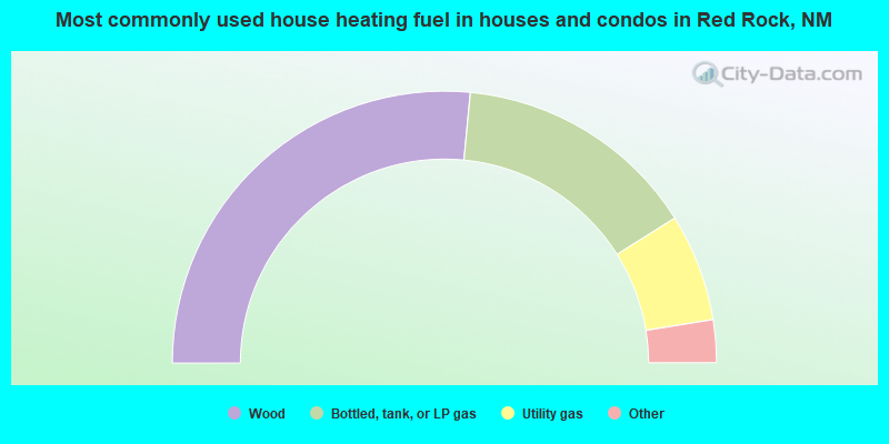
- 53.1%Wood
- 29.1%Bottled, tank, or LP gas
- 12.8%Utility gas
- 2.6%Electricity
- 0.8%Coal or coke
- 0.7%Other fuel
- 0.5%Solar energy
- 0.3%No fuel used
- 0.1%Fuel oil, kerosene, etc.
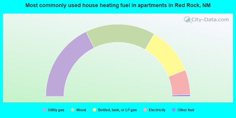
- 35.4%Utility gas
- 31.3%Wood
- 21.4%Bottled, tank, or LP gas
- 11.1%Electricity
- 0.8%Other fuel
Red Rock compared to New Mexico state average:
- Median household income below state average.
- Median house value significantly below state average.
- Black race population percentage significantly below state average.
- Hispanic race population percentage significantly below state average.
- Median age significantly below state average.
- Foreign-born population percentage significantly below state average.
- Renting percentage significantly below state average.
- Length of stay since moving in significantly above state average.
- Number of rooms per house significantly below state average.
- House age significantly below state average.
- Percentage of population with a bachelor's degree or higher significantly below state average.
Red Rock on our top lists:
- #3 on the list of "Top 101 cities with largest percentage of males in industries: gasoline stations (population 5,000+)"
- #6 on the list of "Top 101 cities with largest percentage of males in occupations: bus drivers (population 5,000+)"
- #6 on the list of "Top 101 cities with the largest house values disparities (population 5,000+)"
- #7 on the list of "Top 101 cities with largest percentage of males in industries: miscellaneous durable goods merchant wholesalers (population 5,000+)"
- #7 on the list of "Top 101 cities with largest percentage of males in occupations: financial clerks except bookkeeping, accounting, and auditing clerks (population 5,000+)"
- #10 on the list of "Top 101 cities with largest percentage of males in industries: rail transportation (population 5,000+)"
- #13 on the list of "Top 101 cities with the most people carpooling to work (population 5,000+)"
- #17 on the list of "Top 101 cities with largest percentage of females in occupations: other teachers and instructors, education, training, and library occupations (population 5,000+)"
- #20 on the list of "Top 101 cities with largest percentage of females in industries: miscellaneous durable goods merchant wholesalers (population 5,000+)"
- #21 on the list of "Top 101 cities with largest percentage of males in industries: repair and maintenance (population 5,000+)"
- #22 on the list of "Top 101 cities with largest percentage of females in occupations: cashiers (population 5,000+)"
- #22 on the list of "Top 101 cities with largest percentage of males in industries: social assistance (population 5,000+)"
- #30 on the list of "Top 101 cities with largest percentage of females in industries: gasoline stations (population 5,000+)"
- #30 on the list of "Top 101 cities with largest percentage of females in occupations: other transportation workers (population 5,000+)"
- #31 on the list of "Top 101 cities with largest percentage of females in industries: miscellaneous manufacturing (population 5,000+)"
- #32 on the list of "Top 100 highest located cities (pop. 5,000+)"
- #36 on the list of "Top 101 cities with largest percentage of males in industries: miscellaneous manufacturing (population 5,000+)"
- #37 on the list of "Top 101 cities with largest percentage of males in occupations: other construction workers and helpers (population 5,000+)"
- #63 on the list of "Top 100 cities with largest land areas"
- #68 on the list of "Top 101 cities with largest percentage of males in industries: petroleum and petroleum products merchant wholesalers (population 5,000+)"
- #4 (87316) on the list of "Top 101 zip codes with the largest percentage of Czech first ancestries"
- #29 (87316) on the list of "Top 101 zip codes with the largest percentage of Ukrainian first ancestries"
- #5 on the list of "Top 101 counties with the highest percentage of residents that drank alcohol in the past 30 days"
- #14 on the list of "Top 101 counties with the lowest percentage of residents that smoked 100+ cigarettes in their lives"
- #32 on the list of "Top 101 counties with the largest increase in the number of deaths per 1000 residents 2000-2006 to 2007-2013 (pop. 50,000+)"
- #39 on the list of "Top 101 counties with highest percentage of residents voting for Obama (Democrat) in the 2012 Presidential Election (pop. 50,000+)"
- #78 on the list of "Top 101 counties with the worst general health status score of residents (1-5), 3 years of data"