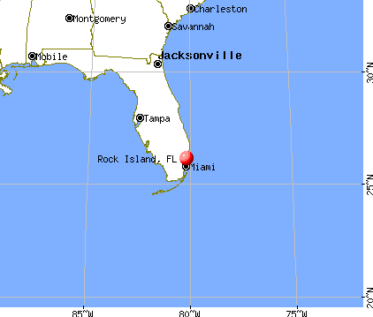
Rock Island, Florida
Submit your own pictures of this place and show them to the world
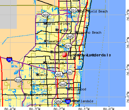
- OSM Map
- General Map
- Google Map
- MSN Map
| Males: 1,511 | |
| Females: 1,782 |
| Median resident age: | 33.6 years |
| Florida median age: | 38.7 years |
Zip codes: 33311.
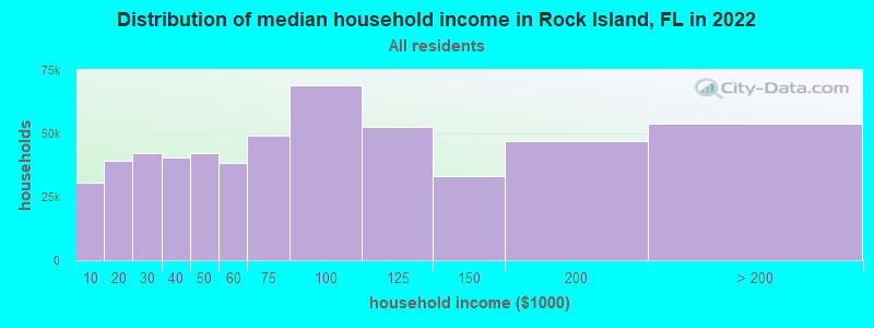
| Rock Island: | $50,676 |
| FL: | $69,303 |
Estimated per capita income in 2022: $20,825 (it was $12,145 in 2000)
Rock Island CDP income, earnings, and wages data
Estimated median house or condo value in 2022: $282,780 (it was $73,800 in 2000)
| Rock Island: | $282,780 |
| FL: | $354,100 |
Mean prices in 2022: all housing units: $501,555; detached houses: $618,997; townhouses or other attached units: $394,360; in 2-unit structures: $434,772; in 3-to-4-unit structures: $337,258; in 5-or-more-unit structures: $307,009; mobile homes: $121,359; occupied boats, rvs, vans, etc.: $108,860
Detailed information about poverty and poor residents in Rock Island, FL


- 2,96096.2%Black alone
- 401.3%White alone
- 341.1%Two or more races
- 270.9%Hispanic
- 70.2%Asian alone
- 40.1%American Indian alone
- 40.1%Other race alone
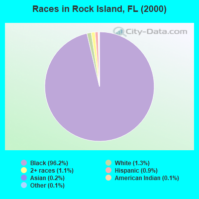
Races in Rock Island detailed stats: ancestries, foreign born residents, place of birth
 Recent articles from our blog. Our writers, many of them Ph.D. graduates or candidates, create easy-to-read articles on a wide variety of topics.


Latest news from Rock Island, FL collected exclusively by city-data.com from local newspapers, TV, and radio stations
Ancestries: West Indian (10.8%), United States (3.8%), Subsaharan African (2.5%).
Current Local Time: EST time zone
Land area: 0.61 square miles.
Population density: 5,365 people per square mile (average).
188 residents are foreign born (5.7% Latin America).
| This place: | 6.1% |
| Florida: | 16.7% |
| Rock Island CDP: | 1.5% ($1,102) |
| Florida: | 1.4% ($1,262) |
Nearest city with pop. 50,000+: Fort Lauderdale, FL  (2.7 miles , pop. 152,397).
Nearest city with pop. 200,000+: Hialeah, FL (21.5 miles , pop. 226,419).
Nearest city with pop. 1,000,000+: Houston, TX (960.9 miles , pop. 1,953,631).
Nearest cities:
), ), ), ), ), )Latitude: 26.15 N, Longitude: 80.18 W
Property values in Rock Island, FL
| Here: | 2.8% |
| Florida: | 2.9% |
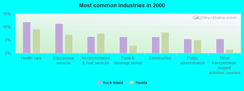
- Health care (12.0%)
- Educational services (11.4%)
- Accommodation & food services (6.4%)
- Food & beverage stores (6.3%)
- Construction (6.2%)
- Public administration (5.4%)
- Other transportation, support activities, couriers (5.4%)
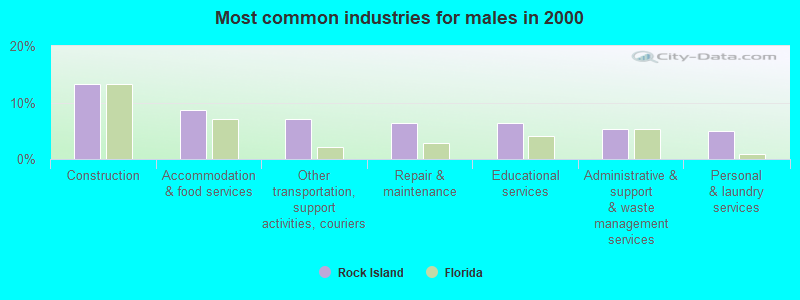
- Construction (13.2%)
- Accommodation & food services (8.7%)
- Other transportation, support activities, couriers (7.1%)
- Repair & maintenance (6.5%)
- Educational services (6.3%)
- Administrative & support & waste management services (5.4%)
- Personal & laundry services (5.0%)
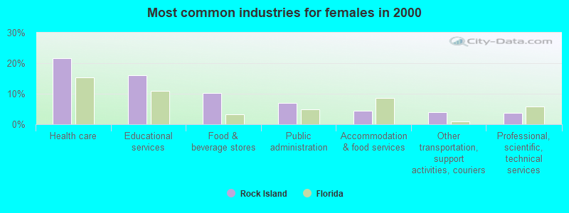
- Health care (21.7%)
- Educational services (16.0%)
- Food & beverage stores (10.2%)
- Public administration (7.0%)
- Accommodation & food services (4.3%)
- Other transportation, support activities, couriers (3.9%)
- Professional, scientific, technical services (3.6%)
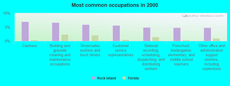
- Cashiers (7.0%)
- Building and grounds cleaning and maintenance occupations (6.8%)
- Driver/sales workers and truck drivers (6.0%)
- Customer service representatives (5.6%)
- Material recording, scheduling, dispatching, and distributing workers (5.0%)
- Preschool, kindergarten, elementary, and middle school teachers (4.8%)
- Other office and administrative support workers, including supervisors (4.8%)
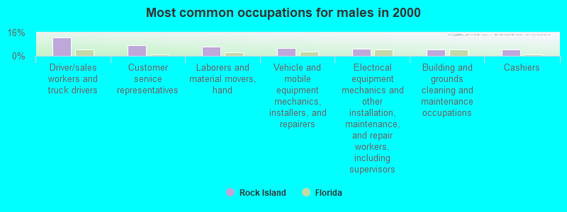
- Driver/sales workers and truck drivers (12.8%)
- Customer service representatives (7.1%)
- Laborers and material movers, hand (6.1%)
- Vehicle and mobile equipment mechanics, installers, and repairers (5.5%)
- Electrical equipment mechanics and other installation, maintenance, and repair workers, including supervisors (4.7%)
- Building and grounds cleaning and maintenance occupations (4.6%)
- Cashiers (4.4%)
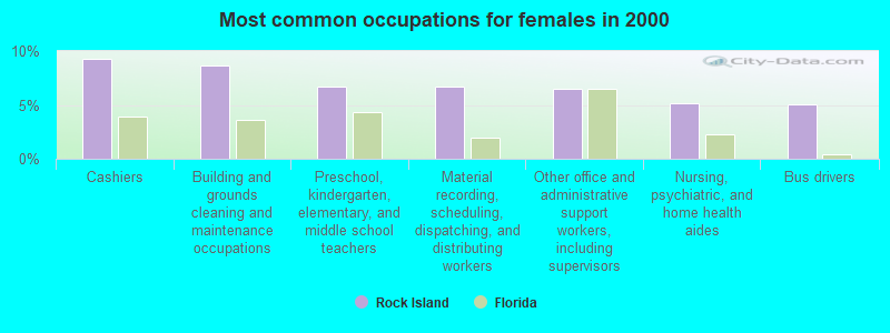
- Cashiers (9.3%)
- Building and grounds cleaning and maintenance occupations (8.7%)
- Preschool, kindergarten, elementary, and middle school teachers (6.7%)
- Material recording, scheduling, dispatching, and distributing workers (6.7%)
- Other office and administrative support workers, including supervisors (6.5%)
- Nursing, psychiatric, and home health aides (5.2%)
- Bus drivers (5.0%)
Average climate in Rock Island, Florida
Based on data reported by over 4,000 weather stations


(lower is better)
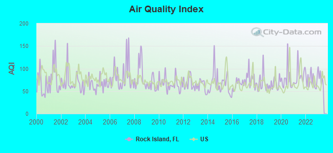
Air Quality Index (AQI) level in 2022 was 73.9. This is about average.
| City: | 73.9 |
| U.S.: | 72.6 |
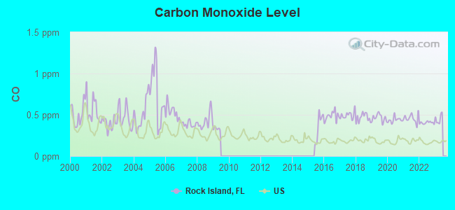
Carbon Monoxide (CO) [ppm] level in 2022 was 0.403. This is significantly worse than average. Closest monitor was 1.6 miles away from the city center.
| City: | 0.403 |
| U.S.: | 0.251 |
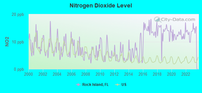
Nitrogen Dioxide (NO2) [ppb] level in 2022 was 12.8. This is significantly worse than average. Closest monitor was 1.6 miles away from the city center.
| City: | 12.8 |
| U.S.: | 5.1 |
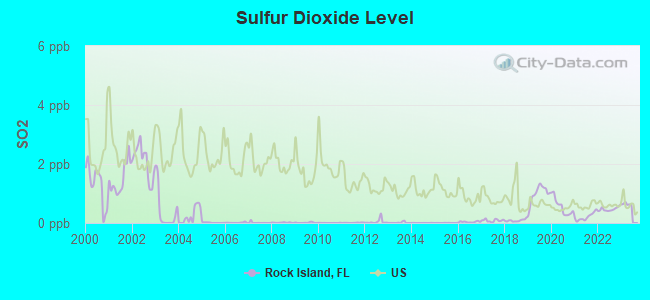
Sulfur Dioxide (SO2) [ppb] level in 2022 was 0.465. This is significantly better than average. Closest monitor was 1.8 miles away from the city center.
| City: | 0.465 |
| U.S.: | 1.515 |
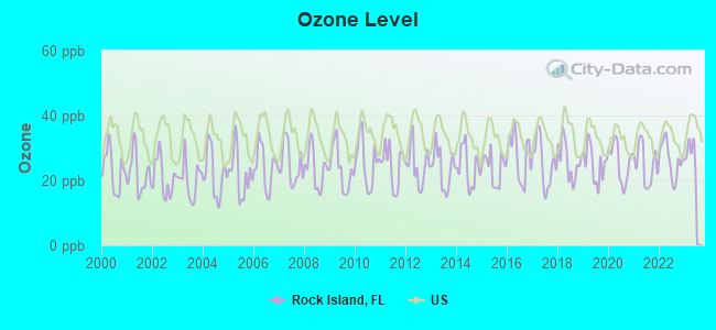
Ozone [ppb] level in 2022 was 26.4. This is better than average. Closest monitor was 1.9 miles away from the city center.
| City: | 26.4 |
| U.S.: | 33.3 |
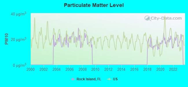
Particulate Matter (PM10) [µg/m3] level in 2022 was 18.5. This is about average. Closest monitor was 1.9 miles away from the city center.
| City: | 18.5 |
| U.S.: | 19.2 |
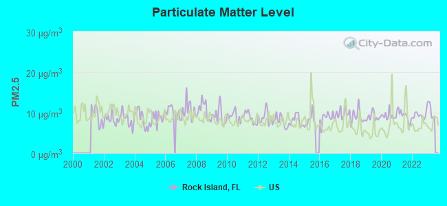
Particulate Matter (PM2.5) [µg/m3] level in 2022 was 9.26. This is about average. Closest monitor was 1.6 miles away from the city center.
| City: | 9.26 |
| U.S.: | 8.11 |
Tornado activity:
Rock Island-area historical tornado activity is slightly below Florida state average. It is 25% smaller than the overall U.S. average.
On 3/1/1980, a category F3 (max. wind speeds 158-206 mph) tornado 1.3 miles away from the Rock Island place center killed one person and injured 33 people and caused between $5,000,000 and $50,000,000 in damages.
On 2/23/1965, a category F3 tornado 3.8 miles away from the place center injured 6 people and caused between $50,000 and $500,000 in damages.
Earthquake activity:
Rock Island-area historical earthquake activity is significantly below Florida state average. It is 99% smaller than the overall U.S. average.On 9/10/2006 at 14:56:08, a magnitude 5.9 (5.9 MB, 5.5 MS, 5.8 MW, Class: Moderate, Intensity: VI - VII) earthquake occurred 400.3 miles away from the city center
On 2/22/1992 at 04:21:34, a magnitude 3.2 (3.2 MB, Depth: 6.2 mi, Class: Light, Intensity: II - III) earthquake occurred 81.4 miles away from Rock Island center
On 6/23/2016 at 17:20:29, a magnitude 3.8 (3.8 ML) earthquake occurred 269.4 miles away from Rock Island center
On 7/16/2016 at 20:00:10, a magnitude 3.7 (3.7 MB) earthquake occurred 253.9 miles away from Rock Island center
On 9/21/2016 at 16:30:52, a magnitude 3.8 (3.8 ML) earthquake occurred 274.3 miles away from Rock Island center
On 9/4/2016 at 18:29:29, a magnitude 3.8 (3.8 ML) earthquake occurred 275.4 miles away from Rock Island center
Magnitude types: body-wave magnitude (MB), local magnitude (ML), surface-wave magnitude (MS), moment magnitude (MW)
Natural disasters:
The number of natural disasters in Broward County (27) is a lot greater than the US average (15).Major Disasters (Presidential) Declared: 15
Emergencies Declared: 8
Causes of natural disasters: Hurricanes: 16, Fires: 3, Floods: 3, Tornadoes: 3, Freezes: 2, Tropical Storms: 2, Heavy Rain: 1, Storm: 1, Wind: 1, Other: 2 (Note: some incidents may be assigned to more than one category).
Hospitals and medical centers near Rock Island:
- ANGEL CARE HOME HEALTH AGENCY, INC (Home Health Center, about 1 miles away; OAKLAND PARK, FL)
- SILVER LIGHTNING HOME HEALTH CARE, LLC (Home Health Center, about 1 miles away; OAKLAND PARK, FL)
- CATHOLIC HOME HEALTH SERVICES OF BROWARD, INC. (Home Health Center, about 2 miles away; LAUDERDALE LAKES, FL)
- SAINT JOHNS NURSING CENTER (Nursing Home, about 2 miles away; LAUDERDALE LAKES, FL)
- CERTIFIED HEALTH CARE SERVICES, INC. (Home Health Center, about 2 miles away; LAUDERDALE LAKES, FL)
- FLORIDA HLTH PROF SVCS, INC (Home Health Center, about 2 miles away; FT LAUDERDALE, FL)
- WILTON MANORS HEALTH AND REHABILITATION CENTER (Nursing Home, about 3 miles away; WILTON MANORS, FL)
Amtrak stations near Rock Island:
- 3 miles: FORT LAUDERDALE (200 SW 21ST TERRACE) . Services: ticket office, partially wheelchair accessible, enclosed waiting area, public restrooms, public payphones, vending machines, free short-term parking, free long-term parking, call for car rental service, call for taxi service, public transit connection.
- 10 miles: HOLLYWOOD (3001 HOLLYWOOD BLVD.) . Services: ticket office, partially wheelchair accessible, enclosed waiting area, public restrooms, public payphones, vending machines, free short-term parking, free long-term parking, taxi stand, public transit connection.
- 12 miles: DEERFIELD BEACH (1300 W. HILLSBORO BLVD.) . Services: ticket office, fully wheelchair accessible, enclosed waiting area, public restrooms, public payphones, free short-term parking, free long-term parking, call for taxi service, public transit connection.
Colleges/universities with over 2000 students nearest to Rock Island:
- Keiser University-Ft Lauderdale (about 3 miles; Fort Lauderdale, FL; Full-time enrollment: 18,270)
- Broward College (about 7 miles; Fort Lauderdale, FL; FT enrollment: 30,322)
- Nova Southeastern University (about 7 miles; Fort Lauderdale, FL; FT enrollment: 25,621)
- Everest University-Pompano Beach (about 8 miles; Pompano Beach, FL; FT enrollment: 2,316)
- DeVry University-Florida (about 16 miles; Miramar, FL; FT enrollment: 3,674)
- Florida Atlantic University (about 16 miles; Boca Raton, FL; FT enrollment: 24,403)
- Lynn University (about 17 miles; Boca Raton, FL; FT enrollment: 2,151)
Points of interest:
Notable location: Tyrone Bryant Branch Library (A). Display/hide its location on the map
| This place: | 3.2 people |
| Florida: | 2.5 people |
| This place: | 78.1% |
| Whole state: | 66.9% |
| This place: | 5.8% |
| Whole state: | 5.8% |
Likely homosexual households (counted as self-reported same-sex unmarried-partner households)
- Lesbian couples: 0.2% of all households
- Gay men: 0.3% of all households
| This place: | 21.7% |
| Whole state: | 12.5% |
| This place: | 8.2% |
| Whole state: | 5.7% |
For population 15 years and over in Rock Island:
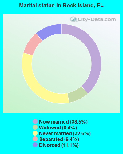
- Never married: 32.6%
- Now married: 38.5%
- Separated: 9.4%
- Widowed: 8.4%
- Divorced: 11.1%
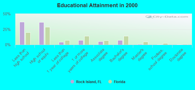
For population 25 years and over in Rock Island:
- High school or higher: 62.9%
- Bachelor's degree or higher: 9.2%
- Graduate or professional degree: 1.9%
- Unemployed: 7.4%
- Mean travel time to work (commute): 23.4 minutes
| Here: | 12.0 |
| Florida average: | 12.6 |
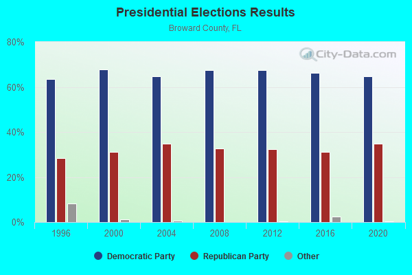
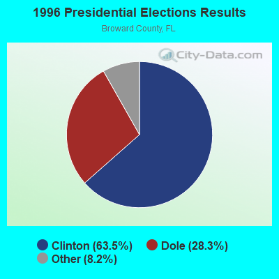
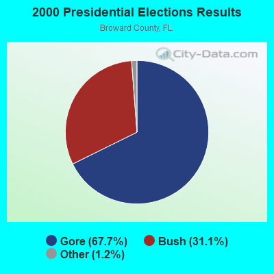
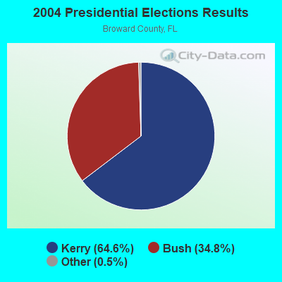
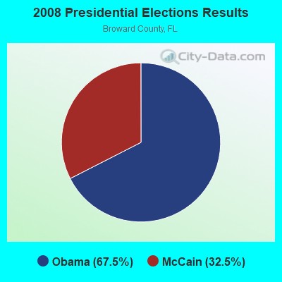
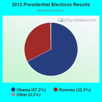
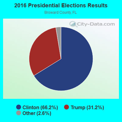
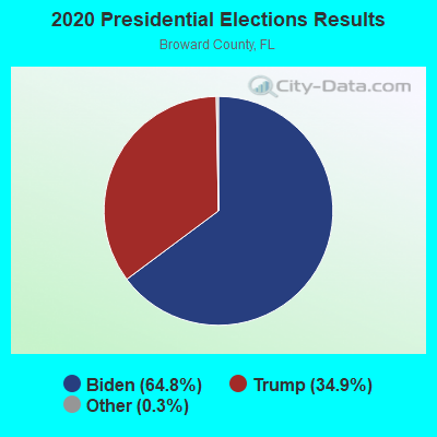
Graphs represent county-level data. Detailed 2008 Election Results
Religion statistics for Rock Island, FL (based on Broward County data)
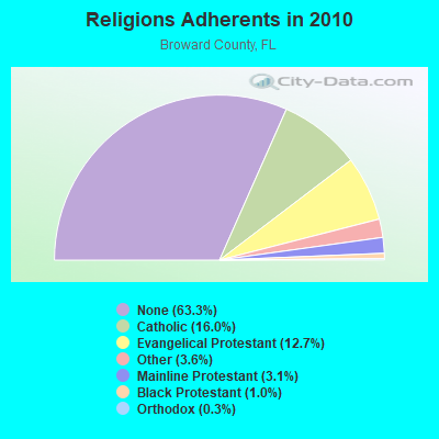
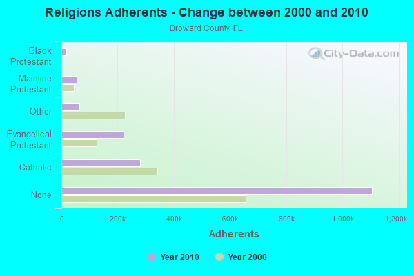
| Religion | Adherents | Congregations |
|---|---|---|
| Catholic | 280,324 | 47 |
| Evangelical Protestant | 221,258 | 701 |
| Other | 63,064 | 143 |
| Mainline Protestant | 53,412 | 88 |
| Black Protestant | 17,866 | 45 |
| Orthodox | 5,648 | 16 |
| None | 1,106,494 | - |
Food Environment Statistics:
| Broward County: | 2.05 / 10,000 pop. |
| Florida: | 2.04 / 10,000 pop. |
| This county: | 0.09 / 10,000 pop. |
| State: | 0.11 / 10,000 pop. |
| Broward County: | 1.53 / 10,000 pop. |
| State: | 1.28 / 10,000 pop. |
| Here: | 2.24 / 10,000 pop. |
| Florida: | 3.04 / 10,000 pop. |
| Here: | 8.00 / 10,000 pop. |
| Florida: | 7.45 / 10,000 pop. |
| This county: | 8.4% |
| State: | 9.2% |
| This county: | 20.6% |
| State: | 23.7% |
| Broward County: | 14.0% |
| Florida: | 14.0% |
6.62% of this county's 2021 resident taxpayers lived in other counties in 2020 ($102,632 average adjusted gross income)
| Here: | 6.62% |
| Florida average: | 8.80% |
0.03% of residents moved from foreign countries ($231 average AGI)
Broward County: 0.03% Florida average: 0.05%
Top counties from which taxpayers relocated into this county between 2020 and 2021:
| from Miami-Dade County, FL | |
| from Palm Beach County, FL | |
| from Orange County, FL |
6.99% of this county's 2020 resident taxpayers moved to other counties in 2021 ($73,182 average adjusted gross income)
| Here: | 6.99% |
| Florida average: | 7.45% |
0.03% of residents moved to foreign countries ($336 average AGI)
Broward County: 0.03% Florida average: 0.04%
Top counties to which taxpayers relocated from this county between 2020 and 2021:
| to Miami-Dade County, FL | |
| to Palm Beach County, FL | |
| to St. Lucie County, FL |
Strongest AM radio stations in Rock Island:
- WWNN (1470 AM; 50 kW; POMPANO BEACH, FL; Owner: WWNN LICENSE, LLC)
- WFLL (1400 AM; 1 kW; FORT LAUDERDALE, FL; Owner: JAMES CRYSTAL ENTERPRISES LICENSES, L.L.C.)
- WEXY (1520 AM; 4 kW; WILTON MANORS, FL; Owner: MULTICULTURAL RADIO BROADCASTING, INC.)
- WRFX (940 AM; 50 kW; MIAMI, FL; Owner: CLEAR CHANNEL BROADCASTING LICENSES, INC.)
- WAQI (710 AM; 50 kW; MIAMI, FL; Owner: LICENSE CORPORATION #1)
- WSRF (1580 AM; 10 kW; FORT LAUDERDALE, FL; Owner: URBAN RADIO OF FLORIDA, LLC)
- WAVS (1170 AM; 5 kW; DAVIE, FL; Owner: RADIO WAVS, INC.)
- WNMA (1210 AM; 49 kW; MIAMI SPRINGS, FL; Owner: RADIO UNICA OF MIAMI LICENSE CORP.)
- WWFE (670 AM; 50 kW; MIAMI, FL; Owner: FENIX BROADCASTING CORP.)
- WFTL (850 AM; 50 kW; WEST PALM BEACH, FL; Owner: JAMES CRYSTAL ENTERPRISES II, L.L.C.)
- WLVJ (1040 AM; 25 kW; BOYNTON BEACH, FL; Owner: JAMES CRYSTAL BOYNTON BEACH, INC.)
- WSUA (1260 AM; 50 kW; MIAMI, FL; Owner: WSUA BROADCASTING CORPORATION)
- WQBA (1140 AM; 50 kW; MIAMI, FL; Owner: WQBA-AM LICENSE CORP.)
Strongest FM radio stations in Rock Island:
- WEDR (99.1 FM; MIAMI, FL; Owner: COX RADIO, INC.)
- WBGG-FM (105.9 FM; FORT LAUDERDALE, FL; Owner: CLEAR CHANNEL BROADCASTING LICENSES, INC.)
- WHYI-FM (100.7 FM; FORT LAUDERDALE, FL; Owner: CLEAR CHANNEL BROADCASTING LICENSES, INC.)
- WKIS (99.9 FM; BOCA RATON, FL; Owner: WKIS LICENSE LIMITED PARTNERSHIP)
- WRMA (106.7 FM; FORT LAUDERDALE, FL; Owner: WRMA LICENSING, INC.)
- WLRN-FM (91.3 FM; MIAMI, FL; Owner: THE SCHOOL BOARD OF MIAMI - DADE COUNTY, FL)
- WFLC (97.3 FM; MIAMI, FL; Owner: COX RADIO, INC.)
- WPYM (93.1 FM; MIAMI, FL; Owner: COX RADIO-MIAMI, LLC)
- WHQT (105.1 FM; CORAL GABLES, FL; Owner: COX RADIO, INC.)
- WLVE (93.9 FM; MIAMI BEACH, FL; Owner: CLEAR CHANNEL BROADCASTING LICENSES, INC.)
- WMIB (103.5 FM; FORT LAUDERDALE, FL; Owner: CLEAR CHANNEL BROADCASTING LICENSES, INC.)
- WMXJ (102.7 FM; POMPANO BEACH, FL; Owner: JEFFERSON-PILOT COMMUNICATIONS CO. OF FLORIDA)
- WPOW (96.5 FM; MIAMI, FL; Owner: WPOW LICENSE LIMITED PARTNERSHIP)
- WZTA (94.9 FM; MIAMI BEACH, FL; Owner: CLEAR CHANNEL BROADCASTING LICENSES, INC.)
- WAFG (90.3 FM; FORT LAUDERDALE, FL; Owner: WESTMINSTER ACADEMY)
- WLYF (101.5 FM; MIAMI, FL; Owner: JEFFERSON-PILOT COMMUNICATIONS CO. OF FLORIDA)
- WXDJ (95.7 FM; NORTH MIAMI BEACH, FL; Owner: WXDJ LICENSING, INC.)
- WEAT-FM (104.3 FM; WEST PALM BEACH, FL; Owner: INFINITY RADIO OPERATIONS INC.)
- WAMR-FM (107.5 FM; MIAMI, FL; Owner: WQBA-FM LICENSE CORP.)
- WRMF (97.9 FM; PALM BEACH, FL; Owner: PBB LICENSES, LLC)
TV broadcast stations around Rock Island:
- WHDT-LP (Channel 44; MIAMI, FL; Owner: GUENTER MARKSTEINER)
- W58BU (Channel 58; HALLANDALE, FL; Owner: NBC STATIONS MANAGEMENT,INC.)
- WPPB-TV (Channel 63; BOCA RATON, FL; Owner: THE SCHOOL BOARD OF BROWARD COUNTY, FLORIDA)
- WPBT (Channel 2; MIAMI, FL; Owner: COMMUNITY TV FOUNDATION OF S. FLORIDA, INC.)
- WHFT-TV (Channel 45; MIAMI, FL; Owner: TRINITY BROADCASTING OF FLORIDA, INC.)
- WSVN (Channel 7; MIAMI, FL; Owner: SUNBEAM TELEVISION CORP.)
- W24CA (Channel 24; MARATHON, FL; Owner: KEY COMMUNICATIONS OF TEXAS)
- WAMI-TV (Channel 69; HOLLYWOOD, FL; Owner: TELEFUTURA MIAMI LLC)
- WSCV (Channel 51; FORT LAUDERDALE, FL; Owner: TELEMUNDO OF FLORIDA LICENSE CORP.)
- WLRN-TV (Channel 17; MIAMI, FL; Owner: THE SCHOOL BOARD OF MIAMI - DADE COUNTY, FL)
- WPLG (Channel 10; MIAMI, FL; Owner: POST-NEWSWEEK STATIONS, FLORIDA, INC.)
- WLTV (Channel 23; MIAMI, FL; Owner: WLTV LICENSE PARTNERSHIP, G.P.)
- WBFS-TV (Channel 33; MIAMI, FL; Owner: VIACOM STATIONS GROUP OF MIAMI INC.)
- WPXM (Channel 35; MIAMI, FL; Owner: PAXSON COMMUNICATIONS LICENSE COMPANY, LLC)
- WLMF-LP (Channel 53; MIAMI, FL; Owner: PAGING SYSTEMS, INC.)
- WBZL (Channel 39; MIAMI, FL; Owner: CHANNEL 39, INC.)
- WDLP-CA (Channel 21; POMPANO BEACH, FL; Owner: WDLP BROADCASTING COMPANY, LLC)
- WPTV (Channel 5; WEST PALM BEACH, FL; Owner: SCRIPPS HOWARD BROADCASTING COMPANY)
- WFUN-CA (Channel 48; MIAMI, ETC., FL; Owner: LOCALONE TEXAS, LTD.)
- WFLX (Channel 29; WEST PALM BEACH, FL; Owner: RAYCOM NATIONAL, INC.)
- WXEL-TV (Channel 42; WEST PALM BEACH, FL; Owner: BARRY TELECOMMUNICATIONS, INC.)
- WTVJ (Channel 6; MIAMI, FL; Owner: NBC STATIONS MANAGEMENT, INC.)
- WPEC (Channel 12; WEST PALM BEACH, FL; Owner: FREEDOM BROADCASTING OF FLORIDA, INC)
- WFGC (Channel 61; PALM BEACH, FL; Owner: CHRISTIAN TELEVISION OF PALM BEACH COUNTY, INC.)
- WGEN-LP (Channel 55; MIAMI, FL; Owner: WDLP BROADCASTING COMPANY, LLC)
FCC Registered Microwave Towers:
1- EMS, 2150 Nw 26 Ave (Lat: 26.154111 Lon: -80.177250), Type: Gtower, Structure height: 122 m, Overall height: 128 m, Call Sign: WRDQ357, Licensee ID: L00006457,
Assigned Frequencies: 6685.00 MHz, 10895.0 MHz, 5974.85 MHz, 6685.00 MHz, Grant Date: 06/25/2019, Expiration Date: 06/25/2029, Certifier: Jose M Dezayas, Registrant: Broward County Board Of County Commissioners, 115 S Andrews Ave, Fort Lauderdale, FL 33301, Phone: (954) 357-8012, Email:
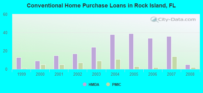
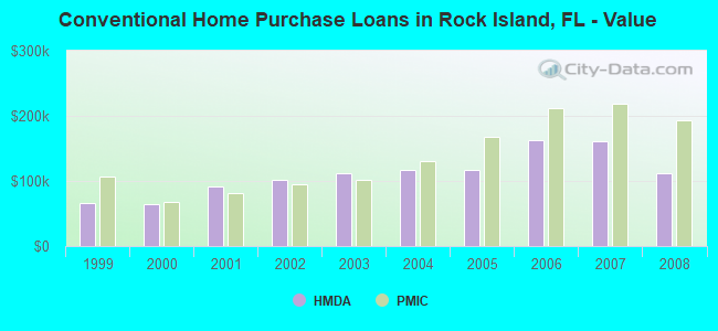
| Home Mortgage Disclosure Act Aggregated Statistics For Year 2009 (Based on 1 partial tract) | ||||||||||
| A) FHA, FSA/RHS & VA Home Purchase Loans | B) Conventional Home Purchase Loans | C) Refinancings | D) Home Improvement Loans | F) Non-occupant Loans on < 5 Family Dwellings (A B C & D) | ||||||
|---|---|---|---|---|---|---|---|---|---|---|
| Number | Average Value | Number | Average Value | Number | Average Value | Number | Average Value | Number | Average Value | |
| LOANS ORIGINATED | 2 | $87,940 | 0 | $0 | 8 | $146,246 | 0 | $0 | 1 | $138,260 |
| APPLICATIONS APPROVED, NOT ACCEPTED | 0 | $0 | 1 | $46,240 | 1 | $112,870 | 0 | $0 | 1 | $46,240 |
| APPLICATIONS DENIED | 2 | $98,140 | 2 | $75,700 | 10 | $125,292 | 2 | $23,120 | 2 | $65,500 |
| APPLICATIONS WITHDRAWN | 1 | $55,760 | 0 | $0 | 5 | $136,716 | 0 | $0 | 0 | $0 |
| FILES CLOSED FOR INCOMPLETENESS | 0 | $0 | 0 | $0 | 0 | $0 | 0 | $0 | 0 | $0 |
Detailed HMDA statistics for the following Tracts: 0508.00
| Private Mortgage Insurance Companies Aggregated Statistics For Year 2009 (Based on 1 partial tract) | ||
| A) Conventional Home Purchase Loans | ||
|---|---|---|
| Number | Average Value | |
| LOANS ORIGINATED | 0 | $0 |
| APPLICATIONS APPROVED, NOT ACCEPTED | 1 | $220,300 |
| APPLICATIONS DENIED | 0 | $0 |
| APPLICATIONS WITHDRAWN | 0 | $0 |
| FILES CLOSED FOR INCOMPLETENESS | 0 | $0 |
Detailed PMIC statistics for the following Tracts: 0508.00
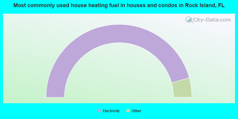
- 91.4%Electricity
- 3.4%Utility gas
- 3.2%Bottled, tank, or LP gas
- 1.1%No fuel used
- 0.8%Fuel oil, kerosene, etc.
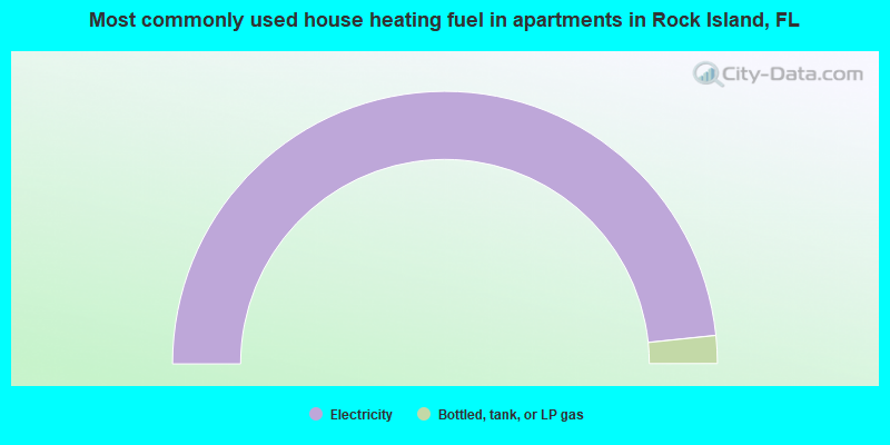
- 96.7%Electricity
- 3.3%Bottled, tank, or LP gas
Rock Island compared to Florida state average:
- Unemployed percentage below state average.
- Black race population percentage significantly above state average.
- Hispanic race population percentage significantly below state average.
- Median age below state average.
- Foreign-born population percentage significantly below state average.
- Renting percentage significantly below state average.
- Length of stay since moving in significantly above state average.
- Number of rooms per house significantly below state average.
- House age significantly below state average.
- Percentage of population with a bachelor's degree or higher significantly below state average.