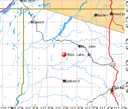
Rock Lake, Washington
Submit your own pictures of this place and show them to the world
- OSM Map
- General Map
- Google Map
- MSN Map
| Males: 1,152 | |
| Females: 1,084 |
| Median resident age: | 37.9 years |
| Washington median age: | 35.3 years |
Zip code: 99171
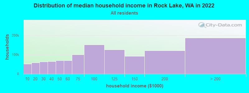
| Rock Lake: | $59,798 |
| WA: | $91,306 |
Estimated per capita income in 2022: $32,906 (it was $15,940 in 2000)
Rock Lake CCD income, earnings, and wages data
Estimated median house or condo value in 2022: $247,551 (it was $75,900 in 2000)
| Rock Lake: | $247,551 |
| WA: | $569,500 |
Detailed information about poverty and poor residents in Rock Lake, WA


- 2,05492.6%White alone
- 552.5%Asian alone
- 562.5%Hispanic
- 261.2%Two or more races
- 130.6%American Indian alone
- 120.5%Black alone
- 10.05%Native Hawaiian and Other
Pacific Islander alone
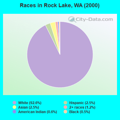
Races in Rock Lake detailed stats: ancestries, foreign born residents, place of birth
 Recent articles from our blog. Our writers, many of them Ph.D. graduates or candidates, create easy-to-read articles on a wide variety of topics.

Current Local Time: PST time zone
Land area: 609.2 square miles.
Population density: 3.7 people per square mile (very low).

| Rock Lake CCD: | 1.0% ($737) |
| Washington: | 1.2% ($1,915) |
Nearest city with pop. 50,000+: Spokane, WA  (45.0 miles , pop. 195,629).
Nearest city with pop. 200,000+: East Seattle, WA (213.6 miles , pop. 480,100).
Nearest city with pop. 1,000,000+: Los Angeles, CA (897.4 miles , pop. 3,694,820).
Nearest cities:
Latitude: 47.05 N, Longitude: 117.69 W
Area code commonly used in this area: 509

| Here: | 4.8% |
| Washington: | 4.6% |

- Agriculture, forestry, fishing & hunting (27.0%)
- Educational services (13.1%)
- Public administration (7.5%)
- Health care (6.6%)
- Accommodation & food services (5.2%)
- Personal & laundry services (2.9%)
- Construction (2.8%)

- Agriculture, forestry, fishing & hunting (41.7%)
- Educational services (7.5%)
- Public administration (6.8%)
- Construction (4.5%)
- Warehousing & storage (3.8%)
- Repair & maintenance (3.8%)
- Farm supplies merchant wholesalers (3.2%)

- Educational services (21.0%)
- Health care (13.8%)
- Accommodation & food services (10.9%)
- Public administration (8.5%)
- Agriculture, forestry, fishing & hunting (6.1%)
- Social assistance (4.8%)
- Professional, scientific, technical services (4.0%)

- Farmers and farm managers (15.4%)
- Agricultural workers, including supervisors (7.7%)
- Driver/sales workers and truck drivers (4.2%)
- Secretaries and administrative assistants (3.9%)
- Preschool, kindergarten, elementary, and middle school teachers (3.7%)
- Building and grounds cleaning and maintenance occupations (3.6%)
- Other management occupations, except farmers and farm managers (3.3%)

- Farmers and farm managers (24.4%)
- Agricultural workers, including supervisors (11.8%)
- Driver/sales workers and truck drivers (6.6%)
- Vehicle and mobile equipment mechanics, installers, and repairers (5.1%)
- Other management occupations, except farmers and farm managers (4.3%)
- Law enforcement workers, including supervisors (3.6%)
- Health technologists and technicians (3.4%)

- Secretaries and administrative assistants (9.3%)
- Bookkeeping, accounting, and auditing clerks (5.9%)
- Preschool, kindergarten, elementary, and middle school teachers (5.6%)
- Building and grounds cleaning and maintenance occupations (5.1%)
- Information and record clerks, except customer service representatives (5.1%)
- Other teachers, instructors, education, training, and library occupations (4.5%)
- Child care workers (4.3%)
Average climate in Rock Lake, Washington
Based on data reported by over 4,000 weather stations


(lower is better)

Air Quality Index (AQI) level in 2022 was 50.8. This is significantly better than average.
| City: | 50.8 |
| U.S.: | 72.6 |

Particulate Matter (PM2.5) [µg/m3] level in 2022 was 5.59. This is significantly better than average. Closest monitor was 19.3 miles away from the city center.
| City: | 5.59 |
| U.S.: | 8.11 |
Earthquake activity:
Rock Lake-area historical earthquake activity is significantly above Washington state average. It is 1084% greater than the overall U.S. average.On 10/28/1983 at 14:06:06, a magnitude 7.3 (6.2 MB, 7.3 MS, 7.0 MW, Class: Major, Intensity: VIII - XII) earthquake occurred 278.6 miles away from the city center, causing 2 deaths (2 shaking deaths) and 3 injuries, causing $15,000,000 total damage
On 4/13/1949 at 19:55:42, a magnitude 7.0 (7.0 UK) earthquake occurred 226.8 miles away from the city center, causing $80,000,000 total damage
On 8/18/1959 at 06:37:13, a magnitude 7.7 (7.7 UK) earthquake occurred 379.9 miles away from Rock Lake center, causing $26,000,000 total damage
On 2/28/2001 at 18:54:32, a magnitude 6.8 (6.5 MB, 6.6 MS, 6.8 MW, Class: Strong, Intensity: VII - IX) earthquake occurred 230.5 miles away from the city center, causing $2,000,000,000 total damage and $305,000,000 insured losses
On 2/28/2001 at 18:54:32, a magnitude 6.8 (6.8 MD, Depth: 32.2 mi) earthquake occurred 237.4 miles away from the city center
On 4/29/1965 at 15:28:43, a magnitude 6.6 (6.6 UK) earthquake occurred 219.2 miles away from the city center, causing $28,000,000 total damage
Magnitude types: body-wave magnitude (MB), duration magnitude (MD), surface-wave magnitude (MS), moment magnitude (MW)
Natural disasters:
The number of natural disasters in Whitman County (14) is near the US average (15).Major Disasters (Presidential) Declared: 12
Emergencies Declared: 2
Causes of natural disasters: Floods: 8, Storms: 5, Mudslides: 3, Heavy Rains: 2, Snows: 2, Winter Storms: 2, Drought: 1, Fire: 1, Hurricane: 1, Landslide: 1, Volcanic Eruption: 1, Wind: 1, Other: 1 (Note: some incidents may be assigned to more than one category).
Colleges/universities with over 2000 students nearest to Rock Lake:
- Eastern Washington University (about 31 miles; Cheney, WA; Full-time enrollment: 11,643)
- Washington State University (about 34 miles; Pullman, WA; FT enrollment: 25,055)
- University of Idaho (about 39 miles; Moscow, ID; FT enrollment: 10,416)
- Spokane Falls Community College (about 45 miles; Spokane, WA; FT enrollment: 6,052)
- Gonzaga University (about 45 miles; Spokane, WA; FT enrollment: 6,780)
- Spokane Community College (about 46 miles; Spokane, WA; FT enrollment: 6,482)
- Whitworth University (about 51 miles; Spokane, WA; FT enrollment: 2,689)
Points of interest:
Notable locations in Rock Lake: Castleton (A), Whitman County Fire District 5 (B), Whitman County Fire District 2 (C), Lamont Fire District 5 (D), Saint John Volunteer Fire Department (E), Whitman County Fire District 6 (F). Display/hide their locations on the map
Cemeteries: Grisham Cemetery (1), Pleasant Valley Cemetery (2), Winona Cemetery (3), Caylor Cemetery (4). Display/hide their locations on the map
Lakes: Darden Pond (A), Cherry Cove Lake (B), Alkali Lake (C), Miller Pond (D), Brown Lake (E), Lake Sixteen (F), Hergert Lake (G), Mud Lake (H). Display/hide their locations on the map
Streams, rivers, and creeks: Cherry Creek (A), Cottonwood Creek (B), Downing Creek (C), Imbler Creek (D), Little Valley Creek (E), Negro Creek (F), Pine Creek (G), Pleasant Valley Creek (H), Rebel Flat Creek (I). Display/hide their locations on the map
Beach: Johnsons Beach (A). Display/hide its location on the map
| This place: | 2.1 people |
| Washington: | 2.5 people |
| This place: | 60.3% |
| Whole state: | 64.4% |
| This place: | 5.0% |
| Whole state: | 7.7% |
Likely homosexual households (counted as self-reported same-sex unmarried-partner households)
- Lesbian couples: 0.5% of all households
- Gay men: 0.3% of all households
| This place: | 11.4% |
| Whole state: | 10.6% |
| This place: | 4.3% |
| Whole state: | 4.6% |
For population 15 years and over in Rock Lake:

- Never married: 25.2%
- Now married: 60.7%
- Separated: 1.4%
- Widowed: 6.4%
- Divorced: 7.7%
For population 25 years and over in Rock Lake:
- High school or higher: 89.1%
- Bachelor's degree or higher: 24.0%
- Graduate or professional degree: 5.6%
- Unemployed: 14.2%
- Mean travel time to work (commute): 19.1 minutes


| Here: | 9.9 |
| Washington average: | 11.3 |
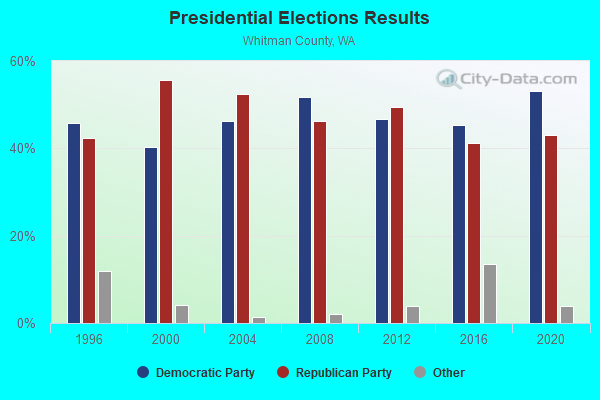
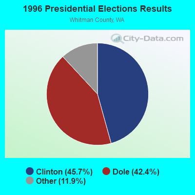
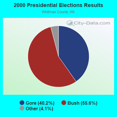
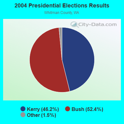
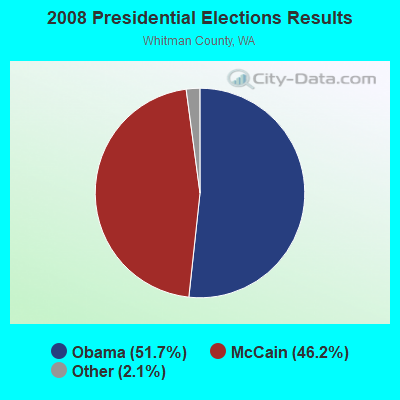
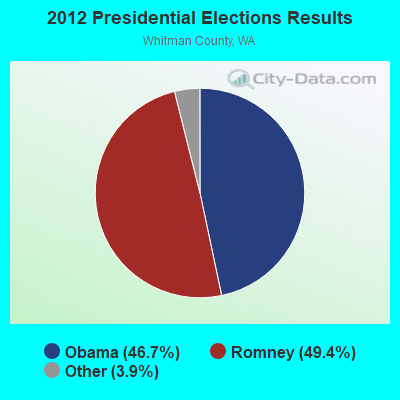
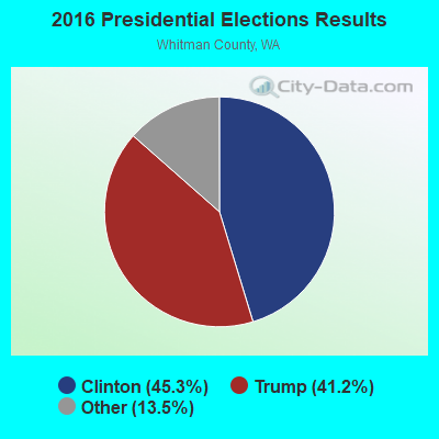
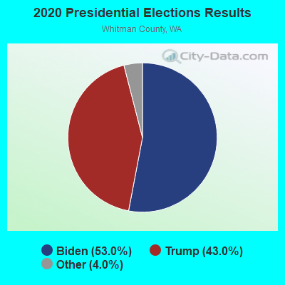
Graphs represent county-level data. Detailed 2008 Election Results
Religion statistics for Rock Lake, WA (based on Whitman County data)
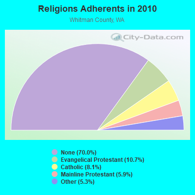
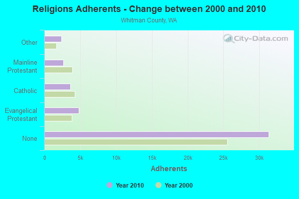
| Religion | Adherents | Congregations |
|---|---|---|
| Evangelical Protestant | 4,782 | 35 |
| Catholic | 3,628 | 9 |
| Mainline Protestant | 2,644 | 20 |
| Other | 2,388 | 10 |
| None | 31,334 | - |
Food Environment Statistics:
| This county: | 2.94 / 10,000 pop. |
| Washington: | 2.06 / 10,000 pop. |
| Whitman County: | 0.74 / 10,000 pop. |
| Washington: | 1.18 / 10,000 pop. |
| Whitman County: | 1.96 / 10,000 pop. |
| Washington: | 2.67 / 10,000 pop. |
| Here: | 7.85 / 10,000 pop. |
| Washington: | 8.26 / 10,000 pop. |
| This county: | 5.4% |
| Washington: | 7.7% |
| This county: | 24.1% |
| Washington: | 25.7% |
| Whitman County: | 8.1% |
| State: | 13.9% |
Strongest AM radio stations in Rock Lake:
- KMAX (840 AM; 10 kW; COLFAX, WA; Owner: PALOUSE COUNTRY, INC.)
- KGA (1510 AM; 50 kW; SPOKANE, WA; Owner: CITADEL BROADCASTING COMPANY)
- KQQQ (1150 AM; 25 kW; PULLMAN, WA; Owner: RADIO PALOUSE, INC.)
- KXLY (920 AM; 20 kW; SPOKANE, WA; Owner: SPOKANE RADIO, INC.)
- KMJY (700 AM; 10 kW; NEWPORT, WA; Owner: JAMES E. AND HELEN G. STARGEL)
- KTBI (810 AM; daytime; 50 kW; EPHRATA, WA; Owner: TACOMA BROADCASTERS, INCORPORATED)
- KQNT (590 AM; 5 kW; SPOKANE, WA; Owner: CAPSTAR TX LIMITED PARTNERSHIP)
- KWSU (1250 AM; 5 kW; PULLMAN, WA; Owner: WASHINGTON STATE UNIVERSITY)
- KJRB (790 AM; 5 kW; SPOKANE, WA; Owner: CITADEL BROADCASTING COMPANY)
- KTRW (970 AM; 5 kW; SPOKANE, WA; Owner: KTRW, LLC)
- KDRK (1050 AM; 5 kW; DISHMAN, WA; Owner: CITADEL BROADCASTING COMPANY)
- KVNI (1080 AM; 10 kW; COEUR D' ALENE, ID; Owner: QUEENB RADIO, INC.)
- KAQQ (1280 AM; 5 kW; SPOKANE, WA)
Strongest FM radio stations in Rock Lake:
- KDRK-FM (93.7 FM; SPOKANE, WA; Owner: CITADEL BROADCASTING COMPANY)
- KIXZ-FM (96.1 FM; OPPORTUNITY, WA; Owner: CAPSTAR TX LIMITED PARTNERSHIP)
- KPBX-FM (91.1 FM; SPOKANE, WA; Owner: SPOKANE PUBLIC RADIO, INC.)
- KMBI-FM (107.9 FM; SPOKANE, WA; Owner: THE MOODY BIBLE INSTITUTE OF CHICAGO)
- KISC (98.1 FM; SPOKANE, WA; Owner: CAPSTAR TX LIMITED PARTNERSHIP)
- KZZU-FM (92.9 FM; SPOKANE, WA; Owner: QUEENB)
- KEYF-FM (101.1 FM; CHENEY, WA; Owner: CITADEL BROADCASTING COMPANY)
- KZBD (105.7 FM; SPOKANE, WA; Owner: CITADEL BROADCASTING COMPANY)
- KRAO-FM (102.5 FM; COLFAX, WA; Owner: PALOUSE COUNTRY, INC.)
- KHTR (104.3 FM; PULLMAN, WA; Owner: RADIO PALOUSE, INC.)
- KCDA (103.1 FM; POST FALLS, ID; Owner: CAPSTAR TX LIMITED PARTNERSHIP)
- KSFC (91.9 FM; SPOKANE, WA; Owner: SPOKANE PUBLIC RADIO)
- KXLY-FM (99.9 FM; SPOKANE, WA; Owner: SPOKANE RADIO, INC.)
- KKZX (98.9 FM; SPOKANE, WA; Owner: CAPSTAR TX LIMITED PARTNERSHIP)
- KEEH (104.9 FM; SPOKANE, WA; Owner: UPPER COLUMBIA MEDIA ASSOCIATION)
- KEWU-FM (89.5 FM; CHENEY, WA; Owner: EASTERN WASHINGTON UNIVERSITY)
- KYWL (103.9 FM; SPOKANE, WA; Owner: CITADEL BROADCASTING COMPANY)
- KAGU (88.7 FM; SPOKANE, WA; Owner: GONZAGA UNIVERSITY TELECOMMUNICATIONS ASSOCIATION)
- KICR (102.3 FM; COEUR D'ALENE, ID; Owner: GREAT NORTHERN BROADCASTING, INC.)
- KHTQ (94.5 FM; HAYDEN, ID; Owner: QUEENB RADIO, INC.)
TV broadcast stations around Rock Lake:
- KREM-TV (Channel 2; SPOKANE, WA; Owner: KING BROADCASTING COMPANY)
- KHQ-TV (Channel 6; SPOKANE, WA; Owner: KHQ, INCORPORATED)
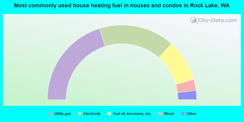
- 40.3%Utility gas
- 32.7%Electricity
- 18.2%Fuel oil, kerosene, etc.
- 4.8%Wood
- 3.5%Bottled, tank, or LP gas
- 0.5%Coal or coke
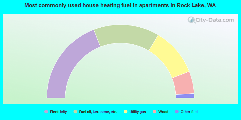
- 38.2%Electricity
- 28.9%Fuel oil, kerosene, etc.
- 21.1%Utility gas
- 9.8%Wood
- 2.0%Other fuel
Rock Lake compared to Washington state average:
- Median household income below state average.
- Median house value significantly below state average.
- Black race population percentage significantly below state average.
- Hispanic race population percentage significantly below state average.
- Median age above state average.
- Foreign-born population percentage significantly below state average.
- Length of stay since moving in significantly above state average.
- Number of rooms per house significantly below state average.
- House age significantly below state average.
- Number of college students above state average.