Rutland, New York
Submit your own pictures of this town and show them to the world
- OSM Map
- Google Map
- MSN Map
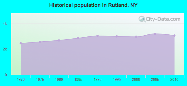
Population change since 2000: +3.4%
 |
| Males: 1,521 | |
| Females: 1,539 |
| Median resident age: | 38.9 years |
| New York median age: | 40.7 years |
Zip codes: 13612.
| Rutland: | $60,423 |
| NY: | $79,557 |
Estimated per capita income in 2022: $28,490 (it was $14,919 in 2000)
Rutland town income, earnings, and wages data
Estimated median house or condo value in 2022: $170,979 (it was $63,600 in 2000)
| Rutland: | $170,979 |
| NY: | $400,400 |
Mean prices in 2022: all housing units: $208,656; detached houses: $224,125; townhouses or other attached units: $288,559; in 2-unit structures: $234,918; mobile homes: $87,861
Detailed information about poverty and poor residents in Rutland, NY


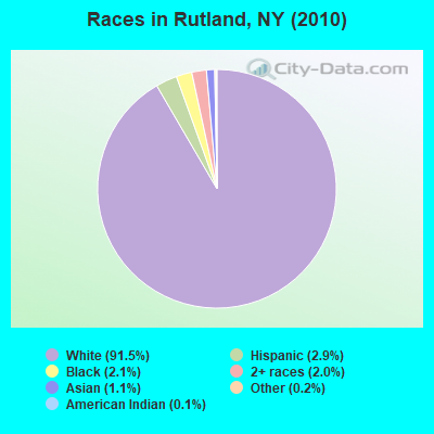
- 2,80191.5%White alone
- 892.9%Hispanic
- 642.1%Black alone
- 612.0%Two or more races
- 331.1%Asian alone
- 50.2%Other race alone
- 40.1%American Indian alone
- 30.10%Native Hawaiian and Other
Pacific Islander alone
Races in Rutland detailed stats: ancestries, foreign born residents, place of birth
 Recent articles from our blog. Our writers, many of them Ph.D. graduates or candidates, create easy-to-read articles on a wide variety of topics.

Ancestries: Irish (17.1%), German (15.5%), English (14.8%), French (10.3%), United States (9.2%), Italian (5.3%).
Current Local Time: EST time zone
Land area: 45.2 square miles.
Population density: 68 people per square mile (very low).
53 residents are foreign born
| This town: | 1.8% |
| New York: | 20.4% |
| Rutland town: | 2.4% ($1,553) |
| New York: | 1.9% ($2,847) |
Nearest city with pop. 50,000+: Clay, NY  (59.4 miles , pop. 58,805).
Nearest city with pop. 200,000+: Rochester, NY (106.4 miles , pop. 219,773).
Nearest city with pop. 1,000,000+: Bronx, NY (236.6 miles , pop. 1,332,650).
Nearest cities:
), ), ), ), )Latitude: 43.96 N, Longitude: 75.79 W
Area code commonly used in this area: 315

| Here: | 5.4% |
| New York: | 4.4% |
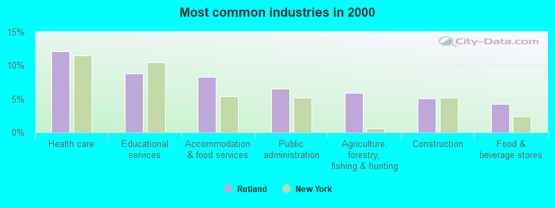
- Health care (12.1%)
- Educational services (8.8%)
- Accommodation & food services (8.3%)
- Public administration (6.5%)
- Agriculture, forestry, fishing & hunting (5.9%)
- Construction (5.0%)
- Food & beverage stores (4.2%)
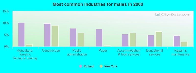
- Agriculture, forestry, fishing & hunting (10.1%)
- Construction (9.8%)
- Public administration (7.8%)
- Paper (7.5%)
- Accommodation & food services (5.3%)
- Educational services (4.8%)
- Repair & maintenance (4.7%)
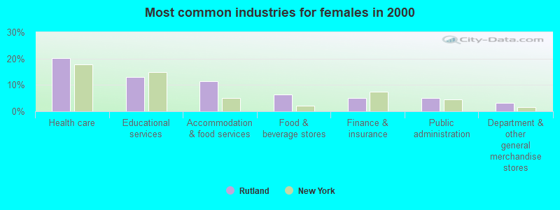
- Health care (20.2%)
- Educational services (13.1%)
- Accommodation & food services (11.4%)
- Food & beverage stores (6.4%)
- Finance & insurance (5.1%)
- Public administration (5.1%)
- Department & other general merchandise stores (3.3%)
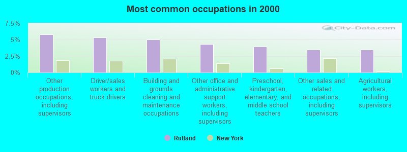
- Other production occupations, including supervisors (5.8%)
- Driver/sales workers and truck drivers (5.4%)
- Building and grounds cleaning and maintenance occupations (5.0%)
- Other office and administrative support workers, including supervisors (4.3%)
- Preschool, kindergarten, elementary, and middle school teachers (3.9%)
- Other sales and related occupations, including supervisors (3.4%)
- Agricultural workers, including supervisors (3.4%)
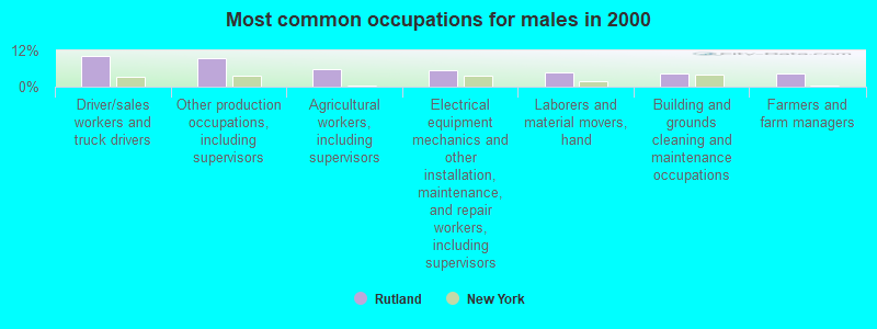
- Driver/sales workers and truck drivers (10.1%)
- Other production occupations, including supervisors (9.3%)
- Agricultural workers, including supervisors (5.9%)
- Electrical equipment mechanics and other installation, maintenance, and repair workers, including supervisors (5.4%)
- Laborers and material movers, hand (4.8%)
- Building and grounds cleaning and maintenance occupations (4.5%)
- Farmers and farm managers (4.2%)
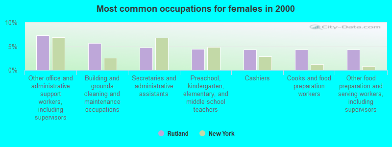
- Other office and administrative support workers, including supervisors (7.3%)
- Building and grounds cleaning and maintenance occupations (5.6%)
- Secretaries and administrative assistants (4.8%)
- Preschool, kindergarten, elementary, and middle school teachers (4.5%)
- Cashiers (4.3%)
- Cooks and food preparation workers (4.3%)
- Other food preparation and serving workers, including supervisors (4.3%)
Average climate in Rutland, New York
Based on data reported by over 4,000 weather stations


Earthquake activity:
Rutland-area historical earthquake activity is significantly above New York state average. It is 70% smaller than the overall U.S. average.On 10/7/1983 at 10:18:46, a magnitude 5.3 (5.1 MB, 5.3 LG, 5.1 ML, Class: Moderate, Intensity: VI - VII) earthquake occurred 72.3 miles away from the city center
On 4/20/2002 at 10:50:47, a magnitude 5.3 (5.3 ML, Depth: 3.0 mi) earthquake occurred 110.7 miles away from the city center
On 4/20/2002 at 10:50:47, a magnitude 5.2 (5.2 MB, 4.2 MS, 5.2 MW, 5.0 MW) earthquake occurred 109.2 miles away from Rutland center
On 9/25/1998 at 19:52:52, a magnitude 5.2 (4.8 MB, 4.3 MS, 5.2 LG, 4.5 MW, Depth: 3.1 mi) earthquake occurred 289.5 miles away from Rutland center
On 1/19/1982 at 00:14:42, a magnitude 4.7 (4.5 MB, 4.7 MD, 4.5 LG, Class: Light, Intensity: IV - V) earthquake occurred 212.0 miles away from the city center
On 6/17/1991 at 08:53:16, a magnitude 4.1 (4.0 MB, 4.0 LG, Depth: 3.1 mi) earthquake occurred 107.8 miles away from Rutland center
Magnitude types: regional Lg-wave magnitude (LG), body-wave magnitude (MB), duration magnitude (MD), local magnitude (ML), surface-wave magnitude (MS), moment magnitude (MW)
Natural disasters:
The number of natural disasters in Jefferson County (16) is near the US average (15).Major Disasters (Presidential) Declared: 7
Emergencies Declared: 7
Causes of natural disasters: Floods: 5, Winter Storms: 4, Snowstorms: 3, Storms: 3, Hurricanes: 2, Winds: 2, Blizzard: 1, Power Outage: 1, Other: 2 (Note: some incidents may be assigned to more than one category).
Hospitals and medical centers near Rutland:
- HOSPICE OF JEFFERSON COUNTY INC (Hospital, about 6 miles away; WATERTOWN, NY)
- SAMARITAN MEDICAL CENTER Acute Care Hospitals (about 6 miles away; WATERTOWN, NY)
- RENAL CARE OF NORTHERN NEW YORK, LLC (Dialysis Facility, about 7 miles away; WATERTOWN, NY)
- SAMARITAN KEEP NURSING HOME INC (Nursing Home, about 7 miles away; WATERTOWN, NY)
- MERCY OF NORTHERN NEW YORK (Nursing Home, about 7 miles away; WATERTOWN, NY)
- JEFFERSON CO PUB HLTH SVS CHHA (Home Health Center, about 7 miles away; WATERTOWN, NY)
- JEFFERSON REHAB CENTER, NYSARC, INC (Hospital, about 8 miles away; WATERTOWN, NY)
Colleges/universities with over 2000 students nearest to Rutland:
- Jefferson Community College (about 8 miles; Watertown, NY; Full-time enrollment: 2,886)
- SUNY College at Oswego (about 52 miles; Oswego, NY; FT enrollment: 7,550)
- St Lawrence University (about 54 miles; Canton, NY; FT enrollment: 2,501)
- SUNY College of Technology at Canton (about 55 miles; Canton, NY; FT enrollment: 3,411)
- Clarkson University (about 63 miles; Potsdam, NY; FT enrollment: 3,472)
- SUNY College at Potsdam (about 64 miles; Potsdam, NY; FT enrollment: 4,307)
- Le Moyne College (about 65 miles; Syracuse, NY; FT enrollment: 3,041)
Points of interest:
Notable locations in Rutland: Harpers Ferry (A), Felts Mills Fire Department (B). Display/hide their locations on the map
Churches in Rutland include: Black River United Methodist Church (A), New Testament Christian Church (B), Middle Road Church (C). Display/hide their locations on the map
Cemeteries: Rutland Hollow Cemetery (1), Underwood Cemetery (2), Cotes Cemetery (3), Maple Hill Cemetery (4), Clark Cemetery (5). Display/hide their locations on the map
Lake: Rutland Lake (A). Display/hide its location on the map
Creeks: White Creek (A), Stebbins Creek (B), Felts Mills Creek (C). Display/hide their locations on the map
| This town: | 2.6 people |
| New York: | 2.6 people |
| This town: | 74.1% |
| Whole state: | 63.5% |
| This town: | 8.7% |
| Whole state: | 6.8% |
Likely homosexual households (counted as self-reported same-sex unmarried-partner households)
- Lesbian couples: 0.6% of all households
- Gay men: 0.3% of all households
| This town: | 12.1% |
| Whole state: | 14.6% |
| This town: | 4.9% |
| Whole state: | 7.4% |
For population 15 years and over in Rutland:
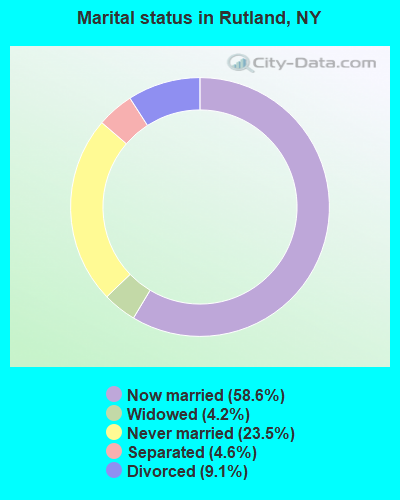
- Never married: 23.5%
- Now married: 58.6%
- Separated: 4.6%
- Widowed: 4.2%
- Divorced: 9.1%
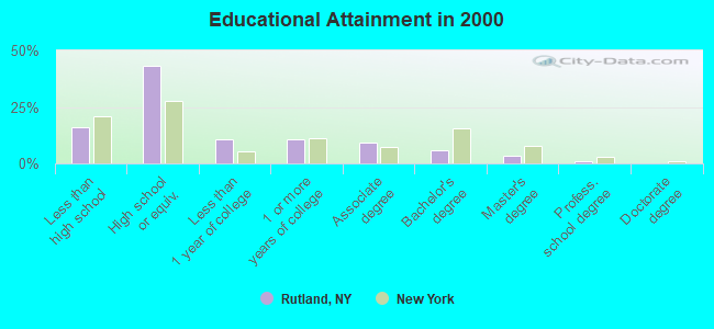
For population 25 years and over in Rutland:
- High school or higher: 84.1%
- Bachelor's degree or higher: 10.5%
- Graduate or professional degree: 4.5%
- Unemployed: 7.8%
- Mean travel time to work (commute): 18.1 minutes
| Here: | 8.4 |
| New York average: | 14.2 |
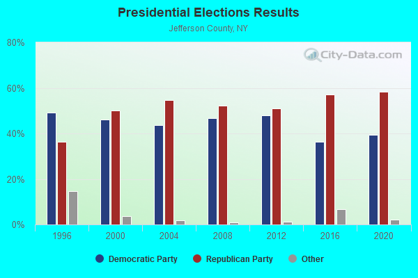
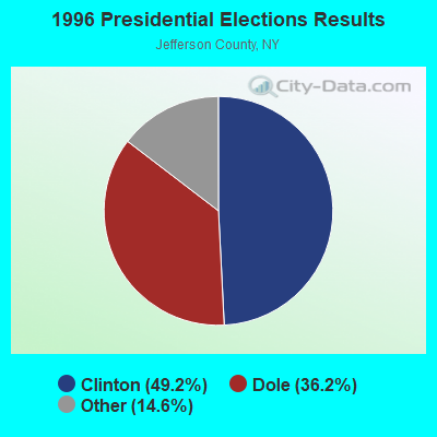
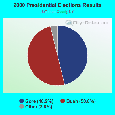
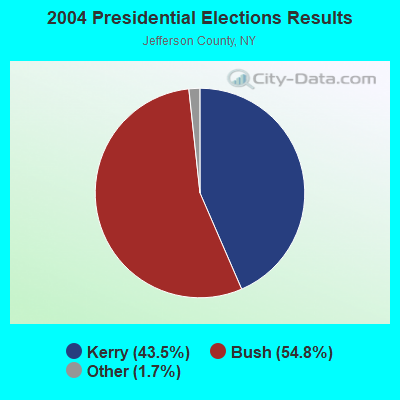
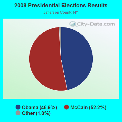
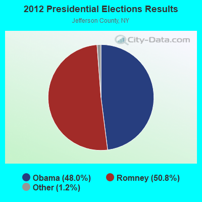
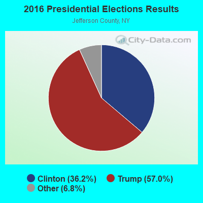
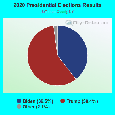
Graphs represent county-level data. Detailed 2008 Election Results
Religion statistics for Rutland, NY (based on Jefferson County data)
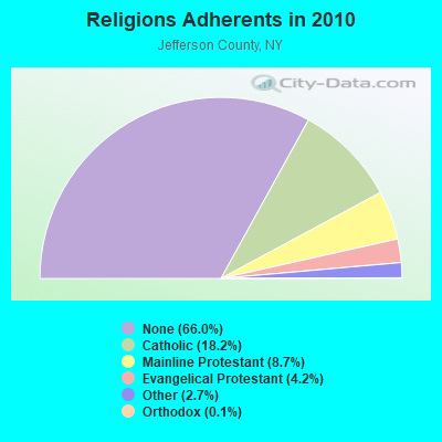
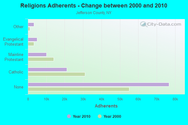
| Religion | Adherents | Congregations |
|---|---|---|
| Catholic | 21,194 | 23 |
| Mainline Protestant | 10,124 | 73 |
| Evangelical Protestant | 4,888 | 43 |
| Other | 3,176 | 8 |
| Orthodox | 140 | 1 |
| Black Protestant | 16 | 1 |
| None | 76,691 | - |
Food Environment Statistics:
| Jefferson County: | 2.37 / 10,000 pop. |
| New York: | 4.13 / 10,000 pop. |
| This county: | 0.08 / 10,000 pop. |
| State: | 0.06 / 10,000 pop. |
| Jefferson County: | 0.59 / 10,000 pop. |
| New York: | 0.92 / 10,000 pop. |
| Jefferson County: | 4.49 / 10,000 pop. |
| New York: | 1.68 / 10,000 pop. |
| Jefferson County: | 9.84 / 10,000 pop. |
| New York: | 8.82 / 10,000 pop. |
| This county: | 7.3% |
| New York: | 8.2% |
| Here: | 28.0% |
| New York: | 23.8% |
| This county: | 10.1% |
| New York: | 15.6% |
10.06% of this county's 2021 resident taxpayers lived in other counties in 2020 ($48,837 average adjusted gross income)
| Here: | 10.06% |
| New York average: | 5.29% |
0.47% of residents moved from foreign countries ($2,248 average AGI)
Jefferson County: 0.47% New York average: 0.01%
Top counties from which taxpayers relocated into this county between 2020 and 2021:
| from St. Lawrence County, NY | |
| from Lewis County, NY | |
| from Oswego County, NY |
10.90% of this county's 2020 resident taxpayers moved to other counties in 2021 ($49,016 average adjusted gross income)
| Here: | 10.90% |
| New York average: | 6.93% |
0.34% of residents moved to foreign countries ($1,564 average AGI)
Jefferson County: 0.34% New York average: 0.02%
Top counties to which taxpayers relocated from this county between 2020 and 2021:
| to Lewis County, NY | |
| to St. Lawrence County, NY | |
| to Onondaga County, NY |
Strongest AM radio stations in Rutland:
- WNER (1410 AM; 5 kW; WATERTOWN, NY)
- WTNY (790 AM; 1 kW; WATERTOWN, NY; Owner: REGENT LICENSEE OF WATERTOWN, INC.)
- WATN (1240 AM; 1 kW; WATERTOWN, NY; Owner: CLANCY-MANCE COMMUNICATIONS, INC)
- WGY (810 AM; 50 kW; SCHENECTADY, NY; Owner: CLEAR CHANNEL BROADCASTING LICENSES, INC.)
- WICY (1490 AM; 50 kW; MALONE, NY; Owner: CARTIER COMMUNICATIONS INC.)
- WHAM (1180 AM; 50 kW; ROCHESTER, NY; Owner: CITICASTERS LICENSES, L.P.)
- WSCP (1070 AM; daytime; 2 kW; SANDY CREEK-PULASKI, NY; Owner: GALAXY COMMUNICATIONS, L.P.)
- WCHP (760 AM; 35 kW; CHAMPLAIN, NY; Owner: CHAMPLAIN RADIO, INC.)
- WPTR (1540 AM; 50 kW; ALBANY, NY; Owner: KIMTRON, INC.)
- WHEN (620 AM; 5 kW; SYRACUSE, NY; Owner: CLEAR CHANNEL BROADCASTING LICENSES, INC.)
- WNNZ (640 AM; 50 kW; WESTFIELD, MA; Owner: CLEAR CHANNEL BROADCASTING LICENSES, INC.)
- WSYR (570 AM; 5 kW; SYRACUSE, NY; Owner: CLEAR CHANNEL BROADCASTING LICENSES, INC.)
- WMCA (570 AM; 50 kW; NEW YORK, NY; Owner: SALEM MEDIA OF NEW YORK, LLC)
Strongest FM radio stations in Rutland:
- WFRY-FM (97.5 FM; WATERTOWN, NY; Owner: REGENT LICENSEE OF WATERTOWN, INC.)
- WSLJ (88.9 FM; WATERTOWN, NY; Owner: THE ST. LAWRENCE UNIVERSITY)
- WTOJ (103.1 FM; CARTHAGE, NY; Owner: CLANCY-MANCE COMMUNICATIONS, INC.)
- WWJS (90.1 FM; WATERTOWN, NY; Owner: LIBERTY COMMUNICATIONS FAMILY B/G)
- WBDI (106.7 FM; COPENHAGEN, NY; Owner: FORCE COMMUNICATIONS, INC)
- WJNY (90.9 FM; WATERTOWN, NY; Owner: PUBLIC B/CNG COUNCIL CENTRAL NY, INC)
- WRVJ (91.7 FM; WATERTOWN, NY; Owner: STATE UNIVERSITY OF NEW YORK)
- WCIZ-FM (93.3 FM; WATERTOWN, NY; Owner: REGENT LICENSEE OF WATERTOWN, INC.)
- WLLG (99.3 FM; LOWVILLE, NY; Owner: THE FLACK BROADCASTING GROUP L.L.C.)
- WOTT (100.7 FM; HENDERSON, NY; Owner: JEFFERSON BROADCASTING, INC.)
- WSCP-FM (101.7 FM; PULASKI, NY; Owner: GALAXY COMMUNICATIONS, L.P.)
- WMHI (94.7 FM; CAPE VINCENT, NY; Owner: MARS HILL BROADCASTING COMPANY INC)
- W240AN (95.9 FM; COPENHAGEN, ETC., NY; Owner: COPENHAGEN CHRISTIAN RADIO)
- W281AA (104.1 FM; WATERTOWN, NY; Owner: CLANCY - MANCE COMMUNICATIONS, INC.)
- W211AR (90.1 FM; WATERTOWN, NY; Owner: BIBLE BROADCASTING NETWORK, INC.)
TV broadcast stations around Rutland:
- WWNY-TV (Channel 7; CARTHAGE, NY; Owner: UNITED COMMUNICATIONS CORPORATION)
- WWTI (Channel 50; WATERTOWN, NY; Owner: CENTRAL NY NEWS, INC.)
- WPBS-TV (Channel 16; WATERTOWN, NY; Owner: ST. LAWRENCE VALLEY EDUCATIONAL TV COUNCIL, INC)
- WNYF-CA (Channel 25; WATERTOWN, NY; Owner: UNITED COMMUNICATIONS CORPORATION)
- WBQZ-LP (Channel 34; WATERTOWN, NY; Owner: ANTHONY DiMARCANTONIO)
- WLOT-LP (Channel 66; WATERTOWN, NY; Owner: R. ANTHONY DiMARCANTONIO)
- WSPX-TV (Channel 56; SYRACUSE, NY; Owner: PAXSON SYRACUSE LICENSE, INC.)
- National Bridge Inventory (NBI) Statistics
- 12Number of bridges
- 85ft / 26.0mTotal length
- $10,356,000Total costs
- 13,391Total average daily traffic
- 1,076Total average daily truck traffic
- 14,420Total future (year 2037) average daily traffic
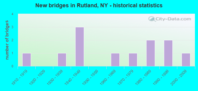
- New bridges - historical statistics
- 11910-1919
- 11930-1939
- 31940-1949
- 11960-1969
- 11970-1979
- 21980-1989
- 21990-1999
- 12000-2009
FCC Registered Antenna Towers:
3- Robert J Folliard, 1.7 Mi W Of Ctr (Lat: 43.956389 Lon: -75.840278), Type: 101.6, Structure height: 36045 m, Overall height: 95.6 m, Registrant: United Communications Corporation, Water-town, Phone: (315) 788-3800
- Miser Rd (Lat: 43.961111 Lon: -75.807778), Type: 97.5, Overall height: 97.5 m, Registrant: Niagara Mohawk Power Corp, Krupcalej@nimo.Com, , Syrac-use, Phone: (315) 428-5997
- 1.7 Mi W Of Ctr (Lat: 43.956389 Lon: -75.840278), Type: 101.6, Overall height: 95.6 m, Registrant: United Communications Corporation, Water-town, Phone: (315) 788-3800
FCC Registered Commercial Land Mobile Towers:
1- Lat: 43.956444 Lon: -75.840750, Call Sign: KRF584, Licensee ID: L01440990,
Assigned Frequencies: 161.670 MHz, Grant Date: 11/14/1969, Expiration Date: 06/01/2023, Registrant: Gray Television Licensee, LLC, 4370 Peachtree Road, Ne, Atlanta, GA 30319
FCC Registered Private Land Mobile Towers:
1- 1.7 Mi W Of Ctr (Lat: 43.956389 Lon: -75.840278), Type: Tower, Structure height: 95.6 m, Overall height: 101.6 m, Call Sign: WQPF407,
Assigned Frequencies: 152.480 MHz, Grant Date: 04/05/2022, Expiration Date: 05/01/2032, Certifier: Kathy M Paskevich, Registrant: Jkl Communications LLC, 142 Avenue C, Williston, VT 05495, Phone: (802) 860-0000, Fax: (802) 860-5037, Email:
FCC Registered Broadcast Land Mobile Towers:
4- 1.7 Mi W Of Ctr (Lat: 43.956389 Lon: -75.840278), Type: Ltower, Structure height: 95.6 m, Overall height: 101.6 m, Call Sign: WPMP795,
Assigned Frequencies: 150.890 MHz, Grant Date: 09/07/2023, Expiration Date: 10/28/2033, Certifier: Garrett Else, Registrant: Akin Gump Strauss Hauer & Feld LLP, 2001 K St Nw, Washington, DC 20006, Phone: (202) 887-4412, Email:
- Miser Rd Approx 1 Mi From Rt 126 (Lat: 43.961167 Lon: -75.807417), Call Sign: WNQC965,
Assigned Frequencies: 451.100 MHz, 153.545 MHz, 451.200 MHz, 153.575 MHz, 47.8200 MHz, 47.8400 MHz, Grant Date: 09/12/2014, Expiration Date: 08/30/2024, Certifier: Chris Kelly, Registrant: Utc Spectrum Services, 1129 20th Street, Nw, Suite 350, Washington, DC 20036, Phone: (202) 833-6803, Fax: (202) 872-1331, Email:
- 32250 St Hwy 126 (Lat: 43.956444 Lon: -75.840750), Type: Tower, Structure height: 60 m, Call Sign: WQFG348,
Assigned Frequencies: 157.450 MHz, Grant Date: 07/07/2006, Expiration Date: 01/03/2007, Cancellation Date: 03/17/2007, Certifier: Glen Morrison, Registrant: United States Licensing, 607 El Mar Drive, Rochester, NY 14616-1035, Phone: (585) 621-4599, Fax: (585) 621-4599, Email:
- Champion Road (Lat: 43.956389 Lon: -75.840278), Type: Tower, Structure height: 95 m, Overall height: 101 m, Call Sign: WQME296,
Assigned Frequencies: 155.145 MHz, Grant Date: 06/07/2011, Expiration Date: 12/04/2011, Cancellation Date: 02/04/2012, Certifier: Christopher Singleton, Registrant: 24 Clay Street, Adams, NY 13605, Phone: (315) 836-4367, Email:
FCC Registered Microwave Towers:
6 (See the full list of FCC Registered Microwave Towers in this town)FCC Registered Paging Towers:
4 (See the full list of FCC Registered Paging Towers)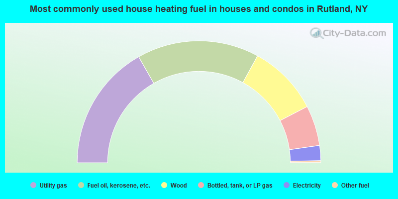
- 33.5%Utility gas
- 32.4%Fuel oil, kerosene, etc.
- 18.8%Wood
- 10.7%Bottled, tank, or LP gas
- 4.0%Electricity
- 0.5%Other fuel
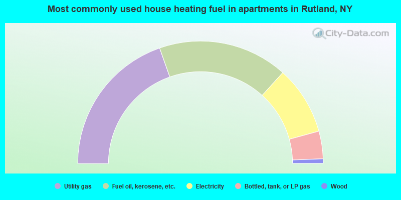
- 39.2%Utility gas
- 34.2%Fuel oil, kerosene, etc.
- 18.1%Electricity
- 7.3%Bottled, tank, or LP gas
- 1.2%Wood
Rutland compared to New York state average:
- Median house value significantly below state average.
- Unemployed percentage below state average.
- Black race population percentage significantly below state average.
- Hispanic race population percentage significantly below state average.
- Foreign-born population percentage significantly below state average.
- Renting percentage below state average.
- Length of stay since moving in significantly above state average.
- Number of rooms per house significantly below state average.
- House age significantly below state average.
- Percentage of population with a bachelor's degree or higher significantly below state average.