Salem, Kentucky

Salem: Old Schoolhouse - Salem - KY
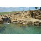
Salem: Faith Pool and Baptismal at Faith Church in Salem, Kentucky
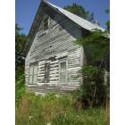
Salem: Old One Room School House in Salem, KY
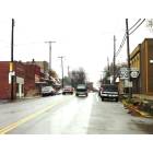
Salem: Main Street, Salem, Kentucky 42078
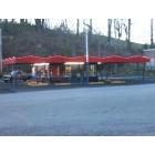
Salem: OLD 50'S STYLE DRIVE IN NEAR SMITHLAND,KY
- add
your


Submit your own pictures of this city and show them to the world
- OSM Map
- General Map
- Google Map
- MSN Map

Population change since 2000: -6.2%
 |
| Males: 349 | |
| Females: 372 |
| Median resident age: | 48.9 years |
| Kentucky median age: | 39.4 years |
Zip codes: 42078.
| Salem: | $46,396 |
| KY: | $59,341 |
Estimated per capita income in 2022: $25,474 (it was $16,156 in 2000)
Salem city income, earnings, and wages data
Estimated median house or condo value in 2022: $99,259 (it was $47,000 in 2000)
| Salem: | $99,259 |
| KY: | $196,300 |
Mean prices in 2022: all housing units: $105,614; detached houses: $111,327; mobile homes: $33,334
Median gross rent in 2022: $642.
(14.7% for White Non-Hispanic residents, 64.7% for Black residents, 41.1% for Hispanic or Latino residents, 10.0% for two or more races residents)
Detailed information about poverty and poor residents in Salem, KY
Compare current foreclosures near Salem, KY:
| Photo | Address | Area | Beds / Baths | Price | Details |
|---|---|---|---|---|---|

|
#1
W Lion Dr
Salem, KY 42078
|
- sq. feet
|
1 baths 3 beds |
$39,900
|
show details |

|
#2
S Hayden Ave
Salem, KY 42078
|
1,048 sq. feet
|
1 baths 2 beds |
show details | |

|
#3
Bethel Hill Rd
Salem, KY 42078
|
1,990 sq. feet
|
1 baths 4 beds |
show details | |

|
#4
Lola Rd
Salem, KY 42078
|
- sq. feet
|
- baths - beds |
show details | |

|
#5
Division St
Rosiclare, IL 62982
|
- sq. feet
|
1 baths 2 beds |
show details | |

|
#6
W Dale Ave
Eddyville, KY 42038
|
1,508 sq. feet
|
2 baths 3 beds |
show details | |

|
#7
Adamson Ln
Marion, KY 42064
|
938 sq. feet
|
1 baths 1 beds |
show details | |

|
#8
Us Highway 60 W
Smithland, KY 42081
|
1,600 sq. feet
|
1 baths 3 beds |
show details | |

|
#9
Arrowhead Rd
Eddyville, KY 42038
|
1,120 sq. feet
|
2 baths 3 beds |
show details | |

|
#10
Jack Thomason Rd
Kuttawa, KY 42055
|
1,974 sq. feet
|
2 baths 3 beds |
show details |
| Photo | Address | Area | Beds / Baths | Price | Details |
|---|---|---|---|---|---|

|
#11
Todd Aly
Marion, KY 42064
|
1,460 sq. feet
|
1 baths 2 beds |
show details | |

|
#12
Willow St
Fredonia, KY 42411
|
1,404 sq. feet
|
2 baths 3 beds |
show details | |

|
#13
Paradise Rd
Grand Rivers, KY 42045
|
1,574 sq. feet
|
1 baths 3 beds |
show details | |

|
#14
Keeling St
Marion, KY 42064
|
1,413 sq. feet
|
1 baths 3 beds |
show details | |

|
#15
Chipps Dr
Marion, KY 42064
|
924 sq. feet
|
1 baths 3 beds |
show details | |

|
#16
Caldwell Springs Rd
Marion, KY 42064
|
1,952 sq. feet
|
1 baths 3 beds |
show details | |

|
#17
Cedar Grove Rd
Burna, KY 42028
|
1,076 sq. feet
|
1 baths 1 beds |
show details | |

|
#18
Bloodworth Rd
Smithland, KY 42081
|
1,800 sq. feet
|
- baths - beds |
show details | |

|
#19
Cruise Rd
Kuttawa, KY 42055
|
- sq. feet
|
- baths - beds |
show details | |

|
#20
Cutoff Rd
Smithland, KY 42081
|
- sq. feet
|
- baths - beds |
show details |
| Photo | Address | Area | Beds / Baths | Price | Details |
|---|---|---|---|---|---|

|
#21
E Fords Ferry Rd
Cave In Rock, IL 62919
|
- sq. feet
|
- baths - beds |
show details | |

|
#22
State Route 810 S
Kuttawa, KY 42055
|
- sq. feet
|
- baths - beds |
show details | |

|
#23
W Dale Ave
Eddyville, KY 42038
|
- sq. feet
|
- baths - beds |
show details | |

|
#24
Rogertown Rd
Elizabethtown, IL 62931
|
- sq. feet
|
- baths - beds |
show details | |

|
#25
Dr Smith Ln
Calvert City, KY 42029
|
- sq. feet
|
- baths - beds |
show details | |

|
#26
Koon Rd
Grand Rivers, KY 42045
|
- sq. feet
|
- baths - beds |
show details | |

|
#27
Daylight Dr
Grand Rivers, KY 42045
|
784 sq. feet
|
- baths - beds |
show details | |

|
#28
Il Route 34 N
Rosiclare, IL 62982
|
- sq. feet
|
- baths - beds |
show details | |

|
#29
Potts Dr
Elizabethtown, IL 62931
|
- sq. feet
|
- baths - beds |
show details | |

|
#30
Mill St
Rosiclare, IL 62982
|
- sq. feet
|
- baths - beds |
show details |
| Photo | Address | Area | Beds / Baths | Price | Details |
|---|---|---|---|---|---|

|
#31
Three Mile Creek Rd
Rosiclare, IL 62982
|
- sq. feet
|
- baths - beds |
show details | |

|
#32
Barnett Chapel Rd
Marion, KY 42064
|
- sq. feet
|
- baths - beds |
show details | |

|
#33
New Salem Rd
Marion, KY 42064
|
- sq. feet
|
- baths - beds |
show details | |

|
#34
State Route 70
Fredonia, KY 42411
|
- sq. feet
|
- baths - beds |
show details | |

|
#35
Paradise Rd
Tiline, KY 42083
|
1,232 sq. feet
|
- baths - beds |
show details | |

|
#36
Mill Rd
Marion, KY 42064
|
- sq. feet
|
- baths - beds |
show details | |

|
#37
Chipps Dr # C
Marion, KY 42064
|
- sq. feet
|
- baths - beds |
show details | |

|
#38
Us Highway 60 E
Smithland, KY 42081
|
- sq. feet
|
- baths - beds |
show details | |

|
#39
2nd St
Marion, KY 42064
|
- sq. feet
|
- baths - beds |
show details | |

|
#40
Level St
Smithland, KY 42081
|
- sq. feet
|
- baths - beds |
show details |
| Photo | Address | Area | Beds / Baths | Price | Details |
|---|---|---|---|---|---|

|
#41
Calhoun Dr
Grand Rivers, KY 42045
|
- sq. feet
|
- baths - beds |
show details | |

|
#42
State Route 654 N
Marion, KY 42064
|
- sq. feet
|
- baths - beds |
show details | |

|
#43
Red Bud Rd
Grand Rivers, KY 42045
|
- sq. feet
|
- baths - beds |
show details | |

|
#44
Wall St # 6
Kuttawa, KY 42055
|
- sq. feet
|
- baths - beds |
show details | |

|
#45
Sturgis Rd
Marion, KY 42064
|
- sq. feet
|
- baths - beds |
show details | |

|
#46
Tiline Rd
Tiline, KY 42083
|
- sq. feet
|
- baths - beds |
show details | |

|
#47
State Route 70
Fredonia, KY 42411
|
- sq. feet
|
- baths - beds |
show details | |

|
Check over 1 million property listings on Foreclosure.com!
|
browse all offers | |||


- 78088.6%White alone
- 586.6%Hispanic
- 283.2%Two or more races
- 111.2%Black alone
- 20.2%Asian alone

Races in Salem detailed stats: ancestries, foreign born residents, place of birth
According to our research of Kentucky and other state lists, there were 3 registered sex offenders living in Salem, Kentucky as of April 24, 2024.
The ratio of all residents to sex offenders in Salem is 257 to 1.
 Recent articles from our blog. Our writers, many of them Ph.D. graduates or candidates, create easy-to-read articles on a wide variety of topics.


 | Housing costs in Eastern Kentucky? (4 replies) |
| The difference between upper midwest and lower midwest (122 replies) |
| Information about moving to Georgetown (12 replies) |
| Is Louisville Southern or Midwestern? (148 replies) |
| Why are people from northern kentucky considered yankees to the rest of the state (175 replies) |
| Lexington KY or Athens GA? (21 replies) |
Latest news from Salem, KY collected exclusively by city-data.com from local newspapers, TV, and radio stations
Ancestries: American (29.6%), German (11.8%), European (11.5%), English (10.1%), Irish (8.4%), Welsh (1.7%).
Current Local Time: CST time zone
Incorporated on 03/15/1869
Elevation: 448 feet
Land area: 0.78 square miles.
Population density: 926 people per square mile (low).

3 residents are foreign born
| This city: | 0.3% |
| Kentucky: | 4.1% |
Median real estate property taxes paid for housing units with mortgages in 2022: $779 (0.7%)
Median real estate property taxes paid for housing units with no mortgage in 2022: $352 (0.4%)
Nearest city with pop. 50,000+: Evansville, IN  (62.1 miles , pop. 121,582).
Nearest city with pop. 200,000+: Metropolitan Government, TN (112.1 miles , pop. 569,891).
Nearest city with pop. 1,000,000+: Chicago, IL (317.9 miles , pop. 2,896,016).
Nearest cities:
), ), Latitude: 37.26 N, Longitude: 88.24 W
Area code: 270


| Here: | 4.7% |
| Kentucky: | 3.8% |

- Health care (16.0%)
- Educational services (9.1%)
- Construction (7.2%)
- Accommodation & food services (4.2%)
- Mining, quarrying, oil & gas extraction (3.8%)
- Professional, scientific, technical services (3.8%)
- Religious, grantmaking, civic, professional, similar organizations (3.4%)

- Construction (13.8%)
- Mining, quarrying, oil & gas extraction (7.2%)
- Religious, grantmaking, civic, professional, similar organizations (5.8%)
- Transportation equipment (5.1%)
- Educational services (5.1%)
- Health care (4.3%)
- Agriculture, forestry, fishing & hunting (3.6%)

- Health care (28.8%)
- Educational services (13.6%)
- Finance & insurance (6.4%)
- Professional, scientific, technical services (6.4%)
- Food & beverage stores (4.8%)
- Accommodation & food services (4.8%)
- U. S. Postal service (4.0%)

- Other production occupations, including supervisors (6.1%)
- Other management occupations, except farmers and farm managers (5.3%)
- Preschool, kindergarten, elementary, and middle school teachers (4.9%)
- Driver/sales workers and truck drivers (4.6%)
- Other sales and related occupations, including supervisors (4.6%)
- Health technologists and technicians (4.2%)
- Other office and administrative support workers, including supervisors (3.8%)

- Driver/sales workers and truck drivers (8.7%)
- Other production occupations, including supervisors (8.0%)
- Other management occupations, except farmers and farm managers (6.5%)
- Electrical equipment mechanics and other installation, maintenance, and repair workers, including supervisors (6.5%)
- Religious workers (5.8%)
- Retail sales workers, except cashiers (5.1%)
- Other sales and related occupations, including supervisors (5.1%)

- Preschool, kindergarten, elementary, and middle school teachers (8.8%)
- Other office and administrative support workers, including supervisors (8.0%)
- Health technologists and technicians (7.2%)
- Cashiers (7.2%)
- Nursing, psychiatric, and home health aides (6.4%)
- Secretaries and administrative assistants (6.4%)
- Building and grounds cleaning and maintenance occupations (5.6%)
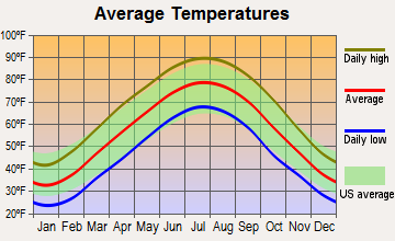
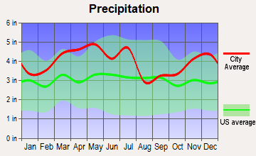
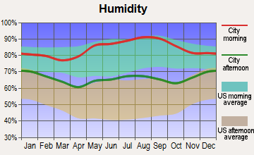
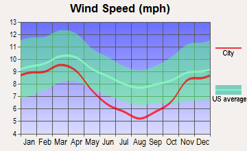
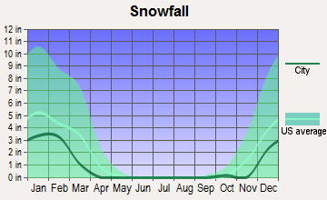
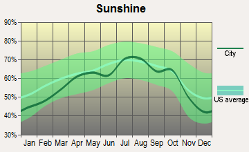
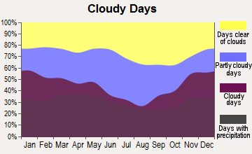
Average climate in Salem, Kentucky
Based on data reported by over 4,000 weather stations
(lower is better)

Air Quality Index (AQI) level in 2022 was 70.9. This is about average.
| City: | 70.9 |
| U.S.: | 72.6 |

Carbon Monoxide (CO) [ppm] level in 2000 was 0.102. This is significantly better than average. Closest monitor was 23.2 miles away from the city center.
| City: | 0.102 |
| U.S.: | 0.251 |

Nitrogen Dioxide (NO2) [ppb] level in 2022 was 5.10. This is about average. Closest monitor was 13.4 miles away from the city center.
| City: | 5.10 |
| U.S.: | 5.11 |

Sulfur Dioxide (SO2) [ppb] level in 2022 was 0.675. This is significantly better than average. Closest monitor was 11.3 miles away from the city center.
| City: | 0.675 |
| U.S.: | 1.515 |

Ozone [ppb] level in 2022 was 32.1. This is about average. Closest monitor was 23.2 miles away from the city center.
| City: | 32.1 |
| U.S.: | 33.3 |

Particulate Matter (PM2.5) [µg/m3] level in 2022 was 9.30. This is about average. Closest monitor was 23.2 miles away from the city center.
| City: | 9.30 |
| U.S.: | 8.11 |
Tornado activity:
Salem-area historical tornado activity is slightly above Kentucky state average. It is 63% greater than the overall U.S. average.
On 5/6/2003, a category F4 (max. wind speeds 207-260 mph) tornado 15.4 miles away from the Salem city center killed 2 people and injured 33 people and caused $16 million in damages.
On 3/4/1964, a category F4 tornado 26.7 miles away from the city center killed 3 people and injured 24 people and caused between $50,000 and $500,000 in damages.
Earthquake activity:
Salem-area historical earthquake activity is significantly above Kentucky state average. It is 277% greater than the overall U.S. average.On 4/18/2008 at 09:36:59, a magnitude 5.4 (5.1 MB, 4.8 MS, 5.4 MW, 5.2 MW, Class: Moderate, Intensity: VI - VII) earthquake occurred 84.4 miles away from the city center
On 4/18/2008 at 09:36:59, a magnitude 5.2 (5.2 MW, Depth: 8.9 mi) earthquake occurred 84.3 miles away from Salem center
On 6/18/2002 at 17:37:15, a magnitude 5.0 (4.3 MB, 4.6 MW, 5.0 LG) earthquake occurred 56.0 miles away from Salem center
On 9/26/1990 at 13:18:51, a magnitude 5.0 (4.7 MB, 4.8 LG, 5.0 LG, Depth: 7.7 mi) earthquake occurred 71.6 miles away from Salem center
On 6/10/1987 at 23:48:54, a magnitude 5.1 (4.9 MB, 4.4 MS, 4.6 MS, 5.1 LG) earthquake occurred 109.4 miles away from the city center
On 5/4/1991 at 01:18:54, a magnitude 5.0 (4.4 MB, 4.6 LG, 5.0 LG, Depth: 3.1 mi) earthquake occurred 100.0 miles away from Salem center
Magnitude types: regional Lg-wave magnitude (LG), body-wave magnitude (MB), surface-wave magnitude (MS), moment magnitude (MW)
Natural disasters:
The number of natural disasters in Livingston County (19) is greater than the US average (15).Major Disasters (Presidential) Declared: 14
Emergencies Declared: 2
Causes of natural disasters: Storms: 13, Floods: 11, Tornadoes: 6, Mudslides: 4, Landslides: 3, Winter Storms: 3, Snows: 2, Winds: 2, Blizzard: 1, Flash Flood: 1, Freeze: 1, Hurricane: 1, Tropical Depression: 1, Other: 1 (Note: some incidents may be assigned to more than one category).

Hospitals and medical centers in Salem:
Heliports located in Salem:
Colleges/universities with over 2000 students nearest to Salem:
- West Kentucky Community and Technical College (about 28 miles; Paducah, KY; Full-time enrollment: 4,107)
- Madisonville Community College (about 41 miles; Madisonville, KY; FT enrollment: 2,082)
- Murray State University (about 46 miles; Murray, KY; FT enrollment: 8,930)
- Hopkinsville Community College (about 49 miles; Hopkinsville, KY; FT enrollment: 2,269)
- John A Logan College (about 58 miles; Carterville, IL; FT enrollment: 3,995)
- University of Southern Indiana (about 58 miles; Evansville, IN; FT enrollment: 9,532)
- Southern Illinois University-Carbondale (about 63 miles; Carbondale, IL; FT enrollment: 14,539)
Points of interest:
Notable location: Salem Community Volunteer Fire Department (A). Display/hide its location on the map
Church in Salem: Mount Zion Church (A). Display/hide its location on the map
Birthplace of: James Henry Dickey Henderson - Politician.
Drinking water stations with addresses in Salem and their reported violations in the past:
CRITTENDEN-LIVINGSTON CO WATER DISTRICT (Population served: 9,079, Surface water):Past health violations:SALEM MUNICIPAL WATER SYSTEM (Population served: 1,241, Purch surface water):Past monitoring violations:
- MCL, Average - Between JUL-2010 and SEP-2010, Contaminant: Total Haloacetic Acids (HAA5). Follow-up actions: St Public Notif requested (NOV-01-2010), St Formal NOV issued (NOV-01-2010), St Public Notif received (DEC-01-2010), St Compliance achieved (FEB-14-2011)
- MCL, Average - Between APR-2010 and JUN-2010, Contaminant: Total Haloacetic Acids (HAA5). Follow-up actions: St Public Notif requested (JUL-29-2010), St Formal NOV issued (JUL-29-2010), St Public Notif received (AUG-31-2010), St Compliance achieved (FEB-14-2011)
- Follow-up Or Routine LCR Tap M/R - In OCT-01-2004, Contaminant: Lead and Copper Rule. Follow-up actions: St Public Notif requested (FEB-24-2005), St Formal NOV issued (FEB-24-2005), St Compliance achieved (SEP-19-2005), St Public Notif received (JUN-21-2006)
- Follow-up Or Routine LCR Tap M/R - In JAN-01-2003, Contaminant: Lead and Copper Rule. Follow-up actions: St Public Notif requested (FEB-25-2004), St Formal NOV issued (FEB-25-2004), St Public Notif received (APR-03-2007), St Compliance achieved (APR-13-2007)
- One regular monitoring violation
Past monitoring violations:
- One minor monitoring violation
| This city: | 2.2 people |
| Kentucky: | 2.5 people |
| This city: | 64.1% |
| Whole state: | 66.9% |
| This city: | 4.1% |
| Whole state: | 6.4% |
Likely homosexual households (counted as self-reported same-sex unmarried-partner households)
- Lesbian couples: 0.6% of all households
- Gay men: 0.3% of all households
People in group quarters in Salem in 2000:
- 72 people in nursing homes
- 6 people in homes for the mentally retarded
- 2 people in religious group quarters
Banks with branches in Salem (2011 data):
- Regions Bank: Salem Branch at 111 East Main Street, branch established on 1902/10/01. Info updated 2011/02/24: Bank assets: $123,368.2 mil, Deposits: $98,301.3 mil, headquarters in Birmingham, AL, positive income, Commercial Lending Specialization, 1778 total offices, Holding Company: Regions Financial Corporation
- Farmers Bank and Trust Company: Salem Branch at 216 West Main Street, branch established on 2003/04/14. Info updated 2008/06/03: Bank assets: $143.3 mil, Deposits: $110.9 mil, headquarters in Marion, KY, positive income, Agricultural Specialization, 3 total offices, Holding Company: Farmers Bancorp, Inc. Of Marion, Kentucky
For population 15 years and over in Salem:

- Never married: 28.9%
- Now married: 39.0%
- Separated: 1.4%
- Widowed: 13.2%
- Divorced: 17.5%
For population 25 years and over in Salem:
- High school or higher: 83.2%
- Bachelor's degree or higher: 11.5%
- Graduate or professional degree: 6.3%
- Unemployed: 4.7%
- Mean travel time to work (commute): 31.9 minutes


| Here: | 10.0 |
| Kentucky average: | 11.7 |


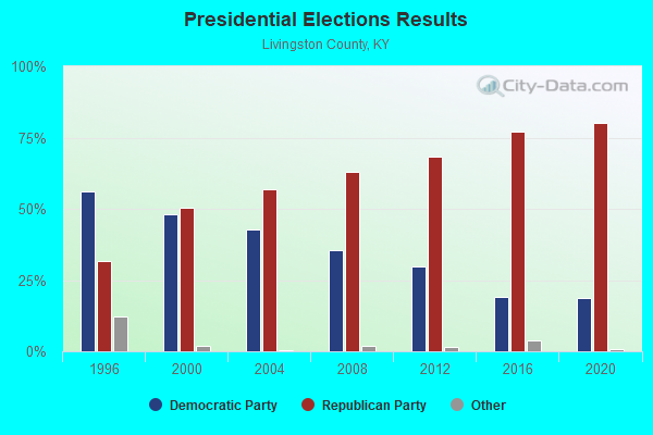
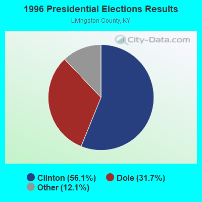
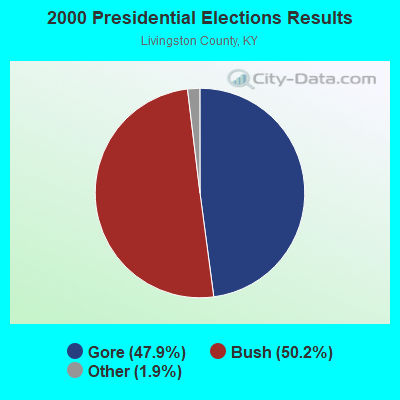
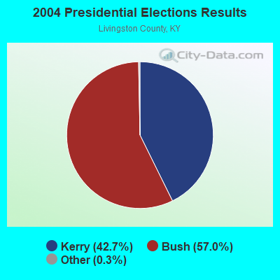
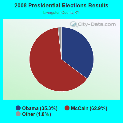
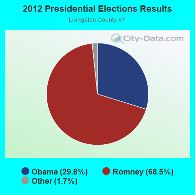
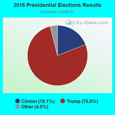
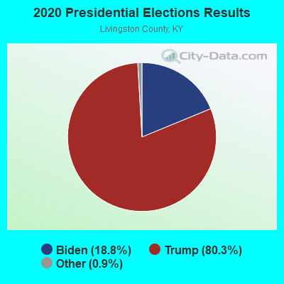
Graphs represent county-level data. Detailed 2008 Election Results
Religion statistics for Salem, KY (based on Livingston County data)
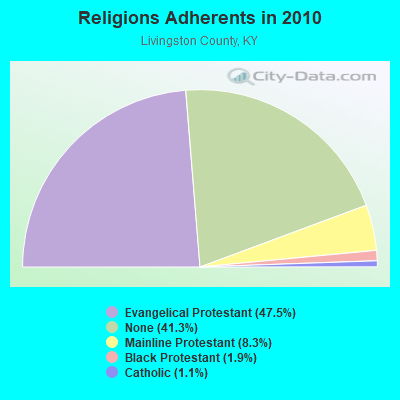
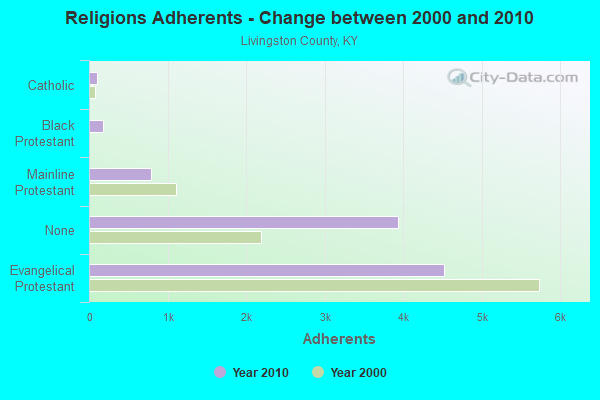
| Religion | Adherents | Congregations |
|---|---|---|
| Evangelical Protestant | 4,519 | 27 |
| Mainline Protestant | 787 | 11 |
| Black Protestant | 178 | 1 |
| Catholic | 101 | 1 |
| Other | 1 | - |
| None | 3,933 | - |
Food Environment Statistics:
| Livingston County: | 2.08 / 10,000 pop. |
| State: | 2.19 / 10,000 pop. |
| Here: | 9.36 / 10,000 pop. |
| Kentucky: | 4.36 / 10,000 pop. |
| Livingston County: | 7.28 / 10,000 pop. |
| Kentucky: | 5.74 / 10,000 pop. |
| Livingston County: | 11.7% |
| State: | 11.0% |
| Livingston County: | 30.5% |
| Kentucky: | 30.0% |
| Here: | 12.3% |
| State: | 15.9% |
Health and Nutrition:
| This city: | 51.2% |
| Kentucky: | 49.9% |
| This city: | 46.4% |
| Kentucky: | 47.0% |
| Salem: | 29.5 |
| Kentucky: | 28.6 |
| This city: | 19.7% |
| Kentucky: | 21.0% |
| Here: | 16.1% |
| Kentucky: | 10.1% |
| Here: | 6.9 |
| Kentucky: | 6.8 |
| Here: | 36.8% |
| Kentucky: | 33.8% |
| Salem: | 55.1% |
| Kentucky: | 56.8% |
| This city: | 73.6% |
| Kentucky: | 78.9% |
More about Health and Nutrition of Salem, KY Residents
| Local government employment and payroll (March 2022) | |||||
| Function | Full-time employees | Monthly full-time payroll | Average yearly full-time wage | Part-time employees | Monthly part-time payroll |
|---|---|---|---|---|---|
| Water Supply | 2 | $952 | $5,712 | 2 | $759 |
| Streets and Highways | 2 | $1,244 | $7,464 | 2 | $253 |
| Solid Waste Management | 2 | $3,884 | $23,304 | 1 | $250 |
| Other Government Administration | 1 | $3,525 | $42,300 | 1 | $549 |
| Judicial and Legal | 1 | $3,321 | $39,852 | 0 | $0 |
| Totals for Government | 8 | $12,927 | $19,391 | 6 | $1,811 |
Salem government finances - Expenditure in 2017 (per resident):
- Current Operations - Sewerage: $224,000 ($310.68)
Central Staff Services: $91,000 ($126.21)
Water Utilities: $75,000 ($104.02)
Regular Highways: $21,000 ($29.13)
- Intergovernmental to Local - Other - General - Other: $71,000 ($98.47)
- Other Capital Outlay - Regular Highways: $48,000 ($66.57)
Sewerage: $16,000 ($22.19)
Water Utilities: $11,000 ($15.26)
- Total Salaries and Wages: $173,000 ($239.94)
- Water Utilities - Interest on Debt: $8,000 ($11.10)
Salem government finances - Revenue in 2017 (per resident):
- Charges - Sewerage: $180,000 ($249.65)
- Local Intergovernmental - Water Utilities: $8,000 ($11.10)
Sewerage: $2,000 ($2.77)
- Miscellaneous - Interest Earnings: $1,000 ($1.39)
- Revenue - Water Utilities: $153,000 ($212.21)
- State Intergovernmental - Other: $48,000 ($66.57)
Highways: $15,000 ($20.80)
- Tax - Property: $83,000 ($115.12)
Public Utilities Sales: $24,000 ($33.29)
Salem government finances - Debt in 2017 (per resident):
- Long Term Debt - Beginning Outstanding - Unspecified Public Purpose: $205,000 ($284.33)
Outstanding Unspecified Public Purpose: $180,000 ($249.65)
Retired Unspecified Public Purpose: $25,000 ($34.67)
Salem government finances - Cash and Securities in 2017 (per resident):
- Other Funds - Cash and Securities: $233,000 ($323.16)
Strongest AM radio stations in Salem:
- WPAD (1560 AM; 10 kW; PADUCAH, KY; Owner: BRISTOL BROADCASTING COMPANY, INC.)
- WSM (650 AM; 50 kW; NASHVILLE, TN; Owner: GAYLORD ENTERTAINMENT COMPANY)
- WCBL (1290 AM; 5 kW; BENTON, KY; Owner: JIM W. FREELAND)
- WDDD (810 AM; 10 kW; JOHNSTON CITY, IL; Owner: CLEAR CHANNEL BROADCASTING LICENSES, INC.)
- WWLK (900 AM; 1 kW; EDDYVILLE, KY; Owner: TILENT, INC.)
- WKDA (1200 AM; 50 kW; NASHVILLE, TN; Owner: RADIO NASHVILLE, INC.)
- WNQM (1300 AM; 50 kW; NASHVILLE, TN; Owner: WNQM. INC.)
- WAMB (1160 AM; 50 kW; DONELSON, TN; Owner: GREAT SOUTHERN BROADCASTING COMPANY, INC.)
- WLAC (1510 AM; 50 kW; NASHVILLE, TN; Owner: CAPSTAR TX LIMITED PARTNERSHIP)
- KXEN (1010 AM; 50 kW; FESTUS-ST. LOUIS, MO; Owner: BDJ RADIO ENTERPRISES, LLC)
- WKYX (570 AM; 1 kW; PADUCAH, KY; Owner: BRISTOL BROADCASTING COMPANY, INC.)
- KMOX (1120 AM; 50 kW; ST. LOUIS, MO; Owner: INFINITY BROADCASTING OPERATIONS, INC.)
- WCRV (640 AM; 50 kW; COLLIERVILLE, TN; Owner: BOTT BROADCASTING COMPANY/TENNESSEE)
Strongest FM radio stations in Salem:
- WCCK (95.7 FM; CALVERT CITY, KY; Owner: JIM W. FREELAND DBA FREELAND BROADCASTING)
- WMJL-FM (102.7 FM; MARION, KY; Owner: JOEMYERS PRODUCTIONS, INC.)
- WLIE-FM (94.3 FM; GOLCONDA, IL; Owner: FOREVER COMMUNICATIONS INC)
- WKYQ (93.3 FM; PADUCAH, KY; Owner: BRISTOL BROADCASTING COMPANY, INC.)
- WVVR (100.3 FM; HOPKINSVILLE, KY; Owner: SAGA COMMUNICATIONS OF TUCKESSEE, LLC)
- WDDJ (96.9 FM; PADUCAH, KY; Owner: BRISTOL BROADCASTING COMPANY, INC.)
- WRIK-FM (98.3 FM; METROPOLIS, IL; Owner: SUN MEDIA, INC.)
- WZZL (106.7 FM; REIDLAND, KY; Owner: W. RUSSELL WITHERS, JR.)
TV broadcast stations around Salem:
- WDKA (Channel 49; PADUCAH, KY; Owner: WDKA ACQUISITION CORPORATION)
- WPSD-TV (Channel 6; PADUCAH, KY; Owner: WPSD-TV, LLC)
- WSIL-TV (Channel 3; HARRISBURG, IL; Owner: WSIL-TV, INC.)
- WKMA-TV (Channel 35; MADISONVILLE, KY; Owner: KENTUCKY AUTHORITY FOR EDUCATIONAL TV)
- W54AE (Channel 54; PADUCAH, KY; Owner: TRI-STATE CHRISTIAN TV, INC.)
- WKPD (Channel 29; PADUCAH, KY; Owner: KENTUCKY AUTHORITY FOR EDUCATIONAL TV)
- WQWQ-LP (Channel 9; PADUCAH, KY; Owner: RAYCOM AMERICA, INC.)
Salem fatal accident list:
May 26, 1992 04:30 PM, 60, Vehicles: 1, Persons: 1, Fatalities: 1
Apr 22, 1988 07:20 PM, 60, Vehicles: 2, Persons: 5, Fatalities: 2, Drunk persons involved: 2
- National Bridge Inventory (NBI) Statistics
- 15Number of bridges
- 98ft / 30.4mTotal length
- $624,000Total costs
- 10,360Total average daily traffic
- 687Total average daily truck traffic
- 14,838Total future (year 2032) average daily traffic

- New bridges - historical statistics
- 21930-1939
- 31940-1949
- 31950-1959
- 11960-1969
- 11980-1989
- 41990-1999
- 12000-2009
FCC Registered Cell Phone Towers:
2 (See the full list of FCC Registered Cell Phone Towers in Salem)FCC Registered Antenna Towers:
14 (See the full list of FCC Registered Antenna Towers)FCC Registered Broadcast Land Mobile Towers:
5- Lockhart Bluff 1 Mi N Hwy 723 (Lat: 37.236722 Lon: -88.294750), Type: Gtower, Structure height: 30.5 m, Call Sign: KVF785,
Assigned Frequencies: 155.655 MHz, Grant Date: 07/07/2015, Expiration Date: 06/04/2025, Registrant: Jackson Purchase Two-Way Radio Svc, Inc, 1201 S Thrid St, Paducah, KY 42003-1612, Phone: (270) 443-6618, Fax: (502) 443-6402, Email:
- Cedar Grove Lookout Twr 3.5 Mi Sw (Lat: 37.237000 Lon: -88.295028), Structure height: 27 m, Call Sign: WPAX912,
Assigned Frequencies: 453.850 MHz, Grant Date: 10/06/2022, Expiration Date: 10/21/2032, Registrant: Kentucky State Police, 1301 Louisville Rd, Frankfort, KY 40601, Phone: (502) 782-2067, Fax: (502) 227-8788, Email:
- Cedar Grove Lookout Tower 3.5 Miles Sowthwest (Lat: 37.237000 Lon: -88.295028), Type: Tower, Structure height: 25 m, Overall height: 27 m, Call Sign: WPXW637, Licensee ID: L00001846,
Assigned Frequencies: 460.087 MHz, 460.237 MHz, Grant Date: 06/23/2003, Expiration Date: 08/31/2003, Cancellation Date: 11/02/2003, Certifier: Brian L O'Reel, Registrant: Kentucky, Commonwealth Of, 1240 Airport Road, Frankfort, KY 40601, Phone: (502) 227-8750, Fax: (502) 227-8788, Email:
- Lat: 37.215556 Lon: -88.253056, Call Sign: WQIG381,
Assigned Frequencies: 159.885 MHz, 160.140 MHz, Grant Date: 11/14/2017, Expiration Date: 01/31/2028, Certifier: Johnathan Gilland, Registrant: Jackson Purchase 2-Way Radio, 1201 S. Third St., Paducah, KY 42003, Phone: (270) 443-5604, Fax: (270) 443-6402, Email:
- 780 Spencer Rd (Lat: 37.197194 Lon: -88.259500), Type: Bant, Structure height: 10 m, Call Sign: WQRR681,
Assigned Frequencies: 150.852 MHz, Grant Date: 07/19/2023, Expiration Date: 07/15/2033, Certifier: Laurie May, Registrant: Mobile Communications America, 1201 S 3rd Street, Paducah, KY 42203, Phone: (270) 443-5604, Fax: (270) 443-6402, Email:
FCC Registered Microwave Towers:
11 (See the full list of FCC Registered Microwave Towers in this town)FCC Registered Amateur Radio Licenses:
20 (See the full list of FCC Registered Amateur Radio Licenses in Salem)FAA Registered Aircraft:
1- Aircraft: CESSNA P210N (Category: Land, Seats: 6, Weight: Up to 12,499 Pounds, Speed: 141 mph), Engine: CONT MOTOR TSIO-520 SER (300 HP) (Reciprocating)
N-Number: 81MT, N81MT, N-81MT, Serial Number: P21000794, Year manufactured: 1981, Airworthiness Date: 01/29/1982, Certificate Issue Date: 09/02/2020
Registrant (LLC): I & S Aviation LLC, 1825 Us Highway 60 E, Salem, KY 42078
2002 - 2018 National Fire Incident Reporting System (NFIRS) incidents
- Fire incident types reported to NFIRS in Salem, KY
- 11043.8%Outside Fires
- 10742.6%Structure Fires
- 187.2%Mobile Property/Vehicle Fires
- 166.4%Other
 According to the data from the years 2002 - 2018 the average number of fires per year is 15. The highest number of reported fire incidents - 41 took place in 2017, and the least - 1 in 2004. The data has a rising trend.
 When looking into fire subcategories, the most incidents belonged to: Outside Fires (43.8%), and Structure Fires (42.6%).
| Most common first names in Salem, KY among deceased individuals | ||
| Name | Count | Lived (average) |
|---|---|---|
| William | 32 | 73.5 years |
| James | 30 | 71.2 years |
| Mary | 23 | 81.1 years |
| John | 16 | 75.0 years |
| Charles | 14 | 72.0 years |
| Henry | 10 | 77.7 years |
| Ruby | 9 | 76.7 years |
| George | 9 | 76.2 years |
| Roy | 9 | 73.8 years |
| Robert | 9 | 61.0 years |
| Most common last names in Salem, KY among deceased individuals | ||
| Last name | Count | Lived (average) |
|---|---|---|
| Croft | 23 | 77.2 years |
| Belt | 18 | 75.2 years |
| Harris | 18 | 74.9 years |
| Kirk | 14 | 73.6 years |
| Watson | 12 | 80.3 years |
| Hardin | 12 | 78.4 years |
| Barnes | 12 | 78.2 years |
| Ramage | 11 | 79.2 years |
| Johnson | 11 | 74.0 years |
| Binkley | 11 | 73.4 years |

- 53.2%Electricity
- 41.4%Bottled, tank, or LP gas
- 4.1%Utility gas
- 1.4%Wood

- 55.8%Electricity
- 29.9%Bottled, tank, or LP gas
- 11.7%Utility gas
- 2.6%Other fuel
Salem compared to Kentucky state average:
- Median house value below state average.
- Unemployed percentage significantly below state average.
- Black race population percentage significantly below state average.
- Hispanic race population percentage above state average.
- Median age significantly above state average.
- Foreign-born population percentage significantly below state average.
- Length of stay since moving in significantly above state average.
- Institutionalized population percentage significantly above state average.
- Percentage of population with a bachelor's degree or higher below state average.

|
Total of 2 patent applications in 2008-2024.