Selma, Alabama
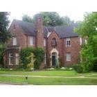
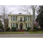
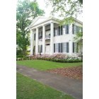
Selma: Historical Home
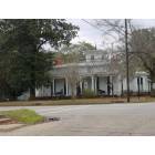
Selma: Corner home with Unusual widow's walk
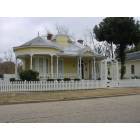
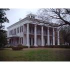
Selma: Unique design in Selma, AL
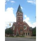
Selma: Church
Selma: Historical Home
Selma: Rare 2nd story bay windows
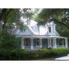
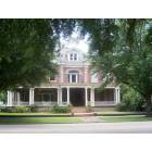
Selma: Historical Home
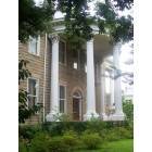
Selma: Sturdivant Hall (Antebellum Home)
Selma: "Parke House" built in 1859, Selma Alabama
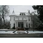
Selma: Snow at 610 Selma Ave
Selma: Historical Home
- see
15
more - add
your


Submit your own pictures of this city and show them to the world
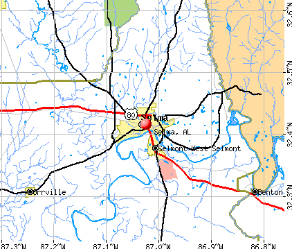
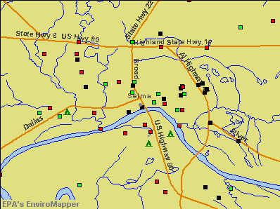
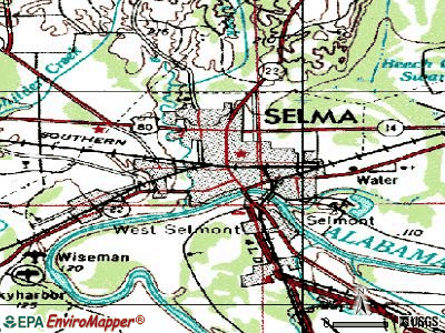
- OSM Map
- General Map
- Google Map
- MSN Map
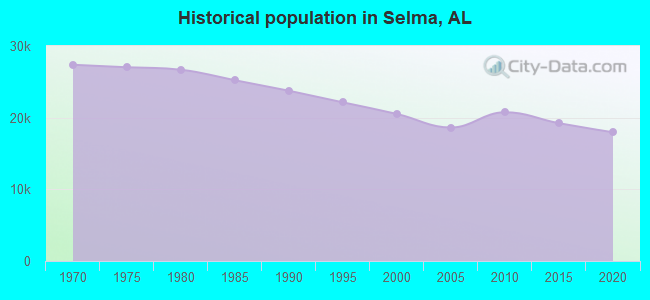
Population change since 2000: -17.0%
 |
| Males: 7,380 | |
| Females: 9,643 |
| Median resident age: | 39.3 years |
| Alabama median age: | 39.6 years |
| Selma: | $31,118 |
| AL: | $59,674 |
Estimated per capita income in 2022: $21,855 (it was $13,369 in 2000)
Selma city income, earnings, and wages data
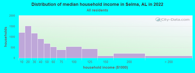
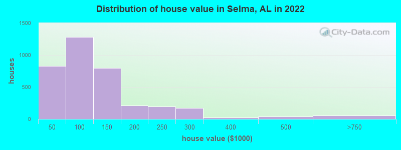
Estimated median house or condo value in 2022: $103,810 (it was $61,800 in 2000)
| Selma: | $103,810 |
| AL: | $200,900 |
Mean prices in 2022: all housing units: $166,934; detached houses: $199,891; townhouses or other attached units: $50,935; in 2-unit structures: $87,751; in 3-to-4-unit structures: $130,889; mobile homes: $78,420
Median gross rent in 2022: $670.
(11.5% for White Non-Hispanic residents, 33.3% for Black residents, 3.1% for Hispanic or Latino residents, 60.4% for American Indian residents, 0.8% for two or more races residents)
Detailed information about poverty and poor residents in Selma, AL


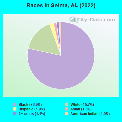
- 13,87976.9%Black alone
- 2,83215.7%White alone
- 3481.9%Hispanic
- 2661.5%Asian alone
- 1961.1%Two or more races
- 1721.0%American Indian alone
- 130.07%Other race alone
According to our research of Alabama and other state lists, there were 78 registered sex offenders living in Selma, Alabama as of April 25, 2024.
The ratio of all residents to sex offenders in Selma is 253 to 1.
Type |
2009 |
2010 |
2011 |
2012 |
2013 |
2014 |
2015 |
2016 |
2017 |
2018 |
2019 |
2020 |
2021 |
2022 |
|---|---|---|---|---|---|---|---|---|---|---|---|---|---|---|
| Murders (per 100,000) | 5 (26.8) | 4 (19.3) | 3 (14.4) | 5 (24.3) | 3 (14.9) | 3 (15.2) | 4 (20.4) | 8 (41.5) | 2 (10.7) | 3 (16.6) | 1 (5.7) | 0 (0.0) | 6 (36.8) | 7 (40.5) |
| Rapes (per 100,000) | 9 (48.2) | 7 (33.7) | 16 (76.7) | 21 (101.9) | 16 (79.6) | 18 (91.3) | 9 (46.0) | 21 (108.9) | 8 (42.8) | 16 (88.6) | 6 (34.2) | 0 (0.0) | 3 (18.4) | 7 (40.5) |
| Robberies (per 100,000) | 48 (257.0) | 28 (134.9) | 71 (340.4) | 61 (296.0) | 42 (209.0) | 70 (355.2) | 28 (143.0) | 79 (409.7) | 38 (203.2) | 36 (199.5) | 8 (45.6) | 0 (0.0) | 8 (49.1) | 11 (63.6) |
| Assaults (per 100,000) | 154 (824.5) | 162 (780.5) | 243 (1,165) | 187 (907.3) | 184 (915.7) | 179 (908.4) | 110 (561.7) | 240 (1,245) | 215 (1,149) | 216 (1,197) | 49 (279.1) | 0 (0.0) | 85 (521.2) | 108 (624.4) |
| Burglaries (per 100,000) | 421 (2,254) | 281 (1,354) | 779 (3,735) | 539 (2,615) | 469 (2,334) | 556 (2,822) | 297 (1,516) | 399 (2,069) | 323 (1,727) | 315 (1,745) | 78 (444.3) | 1 (5.9) | 43 (263.7) | 91 (526.1) |
| Thefts (per 100,000) | 950 (5,086) | 624 (3,006) | 1,547 (7,418) | 1,117 (5,419) | 1,058 (5,265) | 1,394 (7,074) | 731 (3,732) | 988 (5,124) | 821 (4,389) | 704 (3,900) | 221 (1,259) | 3 (17.8) | 143 (876.8) | 166 (959.8) |
| Auto thefts (per 100,000) | 82 (439.0) | 67 (322.8) | 138 (661.7) | 122 (591.9) | 103 (512.6) | 120 (609.0) | 83 (423.8) | 105 (544.5) | 75 (401.0) | 74 (410.0) | 21 (119.6) | 1 (5.9) | 18 (110.4) | 23 (133.0) |
| Arson (per 100,000) | 0 (0.0) | 0 (0.0) | 0 (0.0) | 21 (101.9) | 29 (144.3) | 44 (223.3) | 25 (127.6) | 44 (228.2) | 15 (80.2) | 40 (221.6) | 0 (0.0) | 0 (0.0) | 0 (0.0) | 3 (17.3) |
| City-Data.com crime index | 730.4 | 502.9 | 1036.4 | 847.5 | 754.4 | 921.0 | 522.2 | 935.3 | 675.0 | 714.3 | 199.3 | 1.6 | 269.6 | 343.1 |
The City-Data.com crime index weighs serious crimes and violent crimes more heavily. Higher means more crime, U.S. average is 246.1. It adjusts for the number of visitors and daily workers commuting into cities.
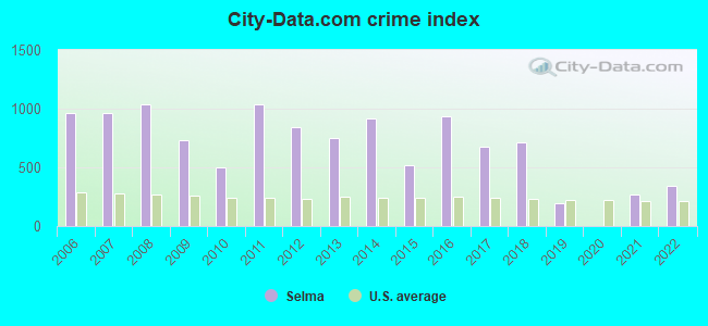
Crime rate in Selma detailed stats: murders, rapes, robberies, assaults, burglaries, thefts, arson
Full-time law enforcement employees in 2021, including police officers: 44 (26 officers - 20 male; 6 female).
| Officers per 1,000 residents here: | 1.59 |
| Alabama average: | 2.40 |
 Recent articles from our blog. Our writers, many of them Ph.D. graduates or candidates, create easy-to-read articles on a wide variety of topics.


 | Selma? (16 replies) |
| My visit to Selma, Alabama and the Peace and Justice Memorial (24 replies) |
| Road Trip to Alabama (31 replies) |
| UPDATED: New and Upcoming Projects. (3716 replies) |
| How would you solve the rural poverty? (193 replies) |
| Cool News (2558 replies) |
Latest news from Selma, AL collected exclusively by city-data.com from local newspapers, TV, and radio stations
Ancestries: American (3.5%), English (2.6%), German (1.3%), African (1.1%).
Current Local Time: CST time zone
Incorporated in 1820
Elevation: 139 feet
Land area: 13.9 square miles.
Population density: 1,228 people per square mile (low).
449 residents are foreign born (1.0% Asia, 0.6% Latin America, 0.5% Europe).
| This city: | 2.5% |
| Alabama: | 3.5% |
Median real estate property taxes paid for housing units with mortgages in 2022: $585 (0.4%)
Median real estate property taxes paid for housing units with no mortgage in 2022: $292 (0.4%)
Nearest city with pop. 50,000+: Montgomery, AL  (43.7 miles , pop. 201,568).
Nearest city with pop. 1,000,000+: Houston, TX (527.8 miles , pop. 1,953,631).
Nearest cities:
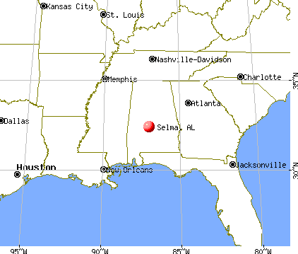
), ), ), ), ), ), )Latitude: 32.42 N, Longitude: 87.02 W
Daytime population change due to commuting: +2,165 (+12.0%)
Workers who live and work in this city: 3,882 (60.7%)
Area code: 334
Selma tourist attractions:
Selma, Alabama accommodation & food services, waste management - Economy and Business Data
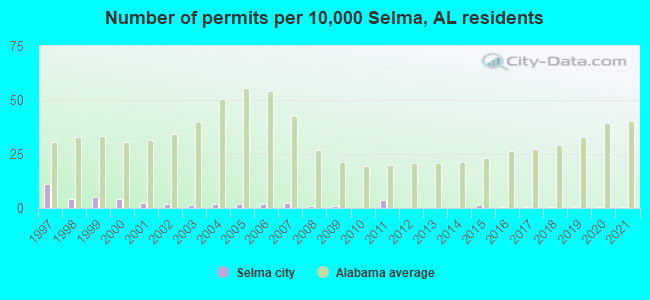
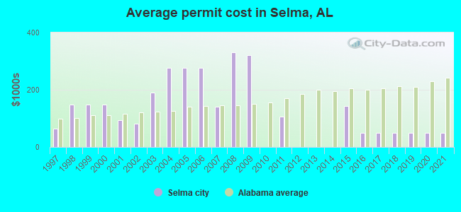
Single-family new house construction building permits:
- 2021: 1 building, cost: $50,000
- 2020: 1 building, cost: $50,000
- 2019: 1 building, cost: $50,000
- 2018: 1 building, cost: $50,000
- 2017: 1 building, cost: $50,000
- 2016: 1 building, cost: $50,000
- 2015: 3 buildings, average cost: $143,000
- 2011: 8 buildings, average cost: $107,400
- 2009: 2 buildings, average cost: $320,500
- 2008: 2 buildings, average cost: $330,700
- 2007: 5 buildings, average cost: $141,100
- 2006: 4 buildings, average cost: $276,300
- 2005: 4 buildings, average cost: $276,300
- 2004: 4 buildings, average cost: $276,300
- 2003: 3 buildings, average cost: $189,700
- 2002: 4 buildings, average cost: $80,500
- 2001: 5 buildings, average cost: $93,200
- 2000: 9 buildings, average cost: $146,800
- 1999: 10 buildings, average cost: $146,800
- 1998: 9 buildings, average cost: $147,200
- 1997: 23 buildings, average cost: $64,600
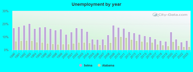
| Here: | 7.2% |
| Alabama: | 2.6% |
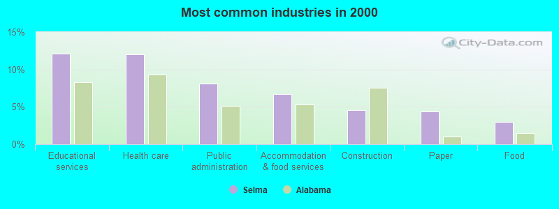
- Educational services (12.1%)
- Health care (12.0%)
- Public administration (8.1%)
- Accommodation & food services (6.7%)
- Construction (4.6%)
- Paper (4.4%)
- Food (3.0%)
- Construction (9.2%)
- Educational services (8.5%)
- Public administration (7.0%)
- Paper (6.7%)
- Health care (5.4%)
- Accommodation & food services (4.6%)
- Machinery (4.1%)
- Health care (18.4%)
- Educational services (15.6%)
- Public administration (9.2%)
- Accommodation & food services (8.6%)
- Social assistance (3.5%)
- Food & beverage stores (2.7%)
- Apparel (2.5%)
- Preschool, kindergarten, elementary, and middle school teachers (5.7%)
- Other production occupations, including supervisors (5.5%)
- Building and grounds cleaning and maintenance occupations (3.7%)
- Other sales and related occupations, including supervisors (3.6%)
- Other management occupations, except farmers and farm managers (3.6%)
- Cooks and food preparation workers (3.5%)
- Electrical equipment mechanics and other installation, maintenance, and repair workers, including supervisors (3.5%)
- Electrical equipment mechanics and other installation, maintenance, and repair workers, including supervisors (7.0%)
- Other production occupations, including supervisors (6.9%)
- Driver/sales workers and truck drivers (5.4%)
- Building and grounds cleaning and maintenance occupations (4.3%)
- Laborers and material movers, hand (3.9%)
- Material recording, scheduling, dispatching, and distributing workers (3.6%)
- Other sales and related occupations, including supervisors (3.0%)
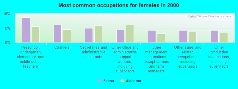
- Preschool, kindergarten, elementary, and middle school teachers (8.6%)
- Cashiers (6.2%)
- Secretaries and administrative assistants (4.9%)
- Other office and administrative support workers, including supervisors (4.3%)
- Other management occupations, except farmers and farm managers (4.3%)
- Other sales and related occupations, including supervisors (4.3%)
- Other production occupations, including supervisors (4.2%)
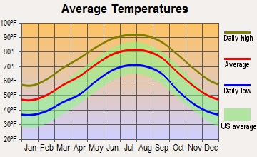
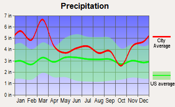
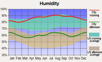
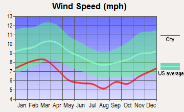
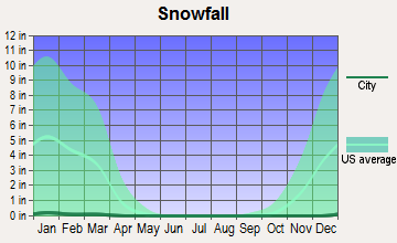
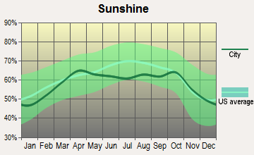
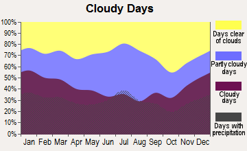
Average climate in Selma, Alabama
Based on data reported by over 4,000 weather stations
|
|

Tornado activity:
Selma-area historical tornado activity is slightly below Alabama state average. It is 40% greater than the overall U.S. average.
On 12/6/1983, a category F3 (max. wind speeds 158-206 mph) tornado 2.9 miles away from the Selma city center killed one person and injured 19 people and caused between $500,000 and $5,000,000 in damages.
On 3/1/2007, a category F4 (max. wind speeds 207-260 mph) tornado 30.5 miles away from the city center killed one person and injured 2 people and caused $2 million in damages.
Earthquake activity:
Selma-area historical earthquake activity is significantly above Alabama state average. It is 92% greater than the overall U.S. average.On 10/24/1997 at 08:35:17, a magnitude 4.9 (4.8 MB, 4.2 MS, 4.9 LG, Depth: 6.2 mi, Class: Light, Intensity: IV - V) earthquake occurred 90.6 miles away from Selma center
On 1/18/1999 at 07:00:53, a magnitude 4.8 (4.8 MB, 4.0 LG, Depth: 0.6 mi) earthquake occurred 69.7 miles away from Selma center
On 4/29/2003 at 08:59:39, a magnitude 4.9 (4.4 MB, 4.6 MW, 4.9 LG) earthquake occurred 164.7 miles away from Selma center
On 11/7/2004 at 11:20:21, a magnitude 4.3 (4.3 MW, Depth: 3.1 mi) earthquake occurred 55.4 miles away from the city center
On 6/24/1975 at 11:11:36, a magnitude 4.5 (4.5 MB) earthquake occurred 101.7 miles away from Selma center
On 4/29/2003 at 08:59:39, a magnitude 4.6 (4.6 MW, Depth: 12.3 mi) earthquake occurred 164.7 miles away from the city center
Magnitude types: regional Lg-wave magnitude (LG), body-wave magnitude (MB), surface-wave magnitude (MS), moment magnitude (MW)
Natural disasters:
The number of natural disasters in Dallas County (19) is greater than the US average (15).Major Disasters (Presidential) Declared: 11
Emergencies Declared: 5
Causes of natural disasters: Storms: 10, Floods: 8, Tornadoes: 7, Hurricanes: 6, Winds: 3, Drought: 1, Snowfall: 1, Winter Storm: 1, Other: 1 (Note: some incidents may be assigned to more than one category).
Hospitals in Selma:
- CAHABA HOSPICE INC (410 CHURCH STERET, SUITE B)
- VAUGHAN REG MED CENTER PARKWAY CAMPUS (Proprietary, 1015 MEDICAL CENTER PARKWAY)
- WIREGRASS HOSPICE SELMA (200 CENTRAL PARK PLACE)
Nursing Homes in Selma:
- LIGHTHOUSE REHABILITATION AND HEALTHCARE CENTER (2911 EARL GOODWIN PARKWAY)
- PARK PLACE NURSING AND REHABILITATION CENTER, LLC (100 PARK PLACE)
- WARREN MANOR HEALTH AND REHABILITATION CENTER (11 BELL ROAD)
Dialysis Facilities in Selma:
- FMC DALLAS COUNTY (200 SOUTH PARK PL)
- FMC SELMA (905 MEDICAL CENTER PARKWAY)
- FMC VALLEY CREEK (201 LINCOLN LANE)
Home Health Centers in Selma:
Airports and heliports located in Selma:
- Craig Field Airport (SEM) (Runways: 1, Air Taxi Ops: 250, Itinerant Ops: 32,000, Local Ops: 2,300, Military Ops: 4,000)
- Vaughan Regional Medical Center Heliport (AL90)
Colleges/Universities in Selma:
- George C Wallace State Community College-Selma (Full-time enrollment: 1,574; Location: 3000 Earl Goodwin Parkway; Public; Website: www.wccs.edu)
- Concordia College Alabama (Full-time enrollment: 515; Location: 1712 Broad Street; Private, not-for-profit; Website: www.ccal.edu/)
- Selma University (Full-time enrollment: 463; Location: 1501 Lapsley St, Dinkins Hall; Private, not-for-profit; Website: selmauniversity.org; Offers Master's degree)
Colleges/universities with over 2000 students nearest to Selma:
- Alabama State University (about 43 miles; Montgomery, AL; Full-time enrollment: 5,457)
- Faulkner University (about 48 miles; Montgomery, AL; FT enrollment: 2,887)
- University of Montevallo (about 49 miles; Montevallo, AL; FT enrollment: 2,826)
- Auburn University at Montgomery (about 50 miles; Montgomery, AL; FT enrollment: 4,092)
- Shelton State Community College (about 58 miles; Tuscaloosa, AL; FT enrollment: 4,106)
- The University of Alabama (about 63 miles; Tuscaloosa, AL; FT enrollment: 30,931)
- University of West Alabama (about 69 miles; Livingston, AL; FT enrollment: 3,394)
Public high schools in Selma:
- SELMA HIGH SCH (Students: 970, Location: 2180 BROAD ST, Grades: 9-12)
- SOUTHSIDE HIGH SCH (Students: 525, Location: 7975 US HIGHWAY 80 E, Grades: 9-12)
- PHOENIX SCH (Students: 61, Location: 501 PLANT ST, Grades: 4-11)
- DALLAS CO CAREER TECH CTR (Location: 1306 ROOSEVELT AVE, Grades: 7-12)
Private high schools in Selma:
Biggest public elementary/middle schools in Selma:
- SELMA MIDDLE CHAT ACAD (Students: 624, Location: 1701 SUMMERFIELD RD, Grades: 7-8)
- SOUTHSIDE PRIMARY SCH (Students: 307, Location: 3104 OLD MONTGOMERY HWY, Grades: KG-2)
- CLARK ELEM SCH (Students: 302, Location: 405 LAWRENCE ST, Grades: PK-5)
- BRUCE K CRAIG ELEM SCH (Students: 301, Location: BUILDING 108 CRAIG IND PARK, Grades: 3-5)
- MEADOWVIEW ELEM SCH (Students: 285, Location: 1816 ORRVILLE RD, Grades: KG-5)
- PAYNE ELEM SCH (Students: 285, Location: 1529 N FRANKLIN ST, Grades: PK-5)
- BRANTLEY ELEM SCH (Students: 269, Location: 5585 WATER AVE, Grades: KG-6)
- SOPHIA P KINGSTON ELEM SCH (Students: 254, Location: 2224 SELMA AVE, Grades: PK-5)
- SCH OF DISCOVERY GENESIS CTR (Students: 248, Location: 400 WASHINGTON ST, Grades: 6)
- KNOX ELEM SCH (Students: 195, Location: 1002 MABRY ST, Grades: PK-5)
Private elementary/middle schools in Selma:
Points of interest:
Notable locations in Selma: Selma Country Club (A), Beech Creek Marina (B), Selma City Marina (C), Dallas County Courthouse (D), Wilson Community Center (E), Warren Manor Nursing Home (F), Old Depot Museum (G), Eastside-Pickard Auditorium (H), Methodist Childrens Home (I), Vaughan Smitherman Museum (J), Selma City Hall (K), Selma Fire Department Station 4 (L), Selma Fire Department Station 2 (M), Selma Fire Department Station 5 (N), Selma Fire Department Station 3 (O). Display/hide their locations on the map
Shopping Centers: Selma Mall Shopping Center (1), Citizens Parkway Plaza Shopping Center (2), Satterfield Plaza Shopping Center (3), Valley Creek Plaza Shopping Center (4). Display/hide their locations on the map
Churches in Selma include: Saint Pauls Christian Methodist Episcopal Church (A), Clinton African Methodist Episcopal Zion Chapel (B), Brown Chapel African Methodist Episcopal Church (C), Alabama Avenue Methodist Church (D), Alabama Avenue Presbyterian Church (E), Assumption Roman Catholic Church (F), Calvary Assembly of God Church (G), Central Baptist Church (H), Church of Christ (I). Display/hide their locations on the map
Cemeteries: Lincoln Cemetery (1), Live Oak Cemetery (2), Fairlawn Memory Gardens (3), Elmwood Cemetery (4), New Live Oak Cemetery (5). Display/hide their locations on the map
Reservoir: Selma Hunting Club Lake (A). Display/hide its location on the map
Streams, rivers, and creeks: Jones Creek (A), Valley Creek (B), Alf Branch (C), Fourmile Branch (D). Display/hide their locations on the map
Parks in Selma include: LaFayette Park (1), Valley Creek Park (2), Bloch Park (3), Icehouse Historic District (4), Old Town Historic District (5), Riverview Historic District (6), Water Avenue Historic District (7), Memorial Stadium (8). Display/hide their locations on the map
Tourist attractions: National Voting Rights Museum & Institute (1012 Water Avenue) (1), Selma Dallas County Friends of the Trail (Cultural Attractions- Events- & Facilities; 816 Selma Avenue) (2), Cahawba Archaelogical Park Old - Director (Historical Places & Services; 719 Tremont Street) (3), Visitor's Information Center (2207 Broad Street) (4). Display/hide their approximate locations on the map
Hotels: Days Inn and Suites Selma (1120 Highland Avenue) (1), Economy Inn (2322 County Road 80) (2), St James Hotel (1200 Water Avenue) (3), Comfort Inn Selma (1812 Highway 14 East) (4), Best Western Inn (1915 West Highland Avenue) (5), Jameson Inn Selma (Sj) (2420 N Broad St) (6), Residence Suites of Selma (2006 West Highland Avenue) (7), Craig Motel (1134 US Highway 80 East) (8), Budget Inn (601 Highland Avenue) (9). Display/hide their approximate locations on the map
Courts: U S Government - U S District Court (908 Alabama Avenue) (1), Tri-County Rental (1807 West Highland Avenue) (2), Dallas County - Courthouse- District Court- Juvenile Probation (105 Lauderdale Street) (3), Dallas County - Courthouse- District Court- Juvenile Judge (105 Lauderdale Street) (4), Dallas County - Courthouse- District Court (105 Lauderdale Street) (5). Display/hide their approximate locations on the map
Birthplace of: Jo Bonner - Alabama Republican politician, Ralph Jordan - College football coach, Jeff Sessions - Senator, Mattie Moss Clark - Gospel singer, Howard W. Gilmore - Navy Medal of Honor recipient, Mia Hamm - (born 1972), soccer player, Benjamin Obomanu - Football wide receiver, Clara Weaver Parrish - Artist, Michael Johnson (defensive end) - Football player, Shwetak Patel - Computer scientist.
Drinking water stations with addresses in Selma and their reported violations in the past:
SELMA WATER WORKS & SEWER BOARD (Population served: 24,039, Groundwater):Past health violations:
- MCL, Monthly (TCR) - In OCT-2008, Contaminant: Coliform. Follow-up actions: St Public Notif requested (NOV-13-2008), St Violation/Reminder Notice (NOV-13-2008), St Compliance achieved (MAY-10-2009)
Drinking water stations with addresses in Selma that have no violations reported:
- DALLAS COUNTY WATER & SEWER AUTHORITY (Population served: 5,292, Primary Water Source Type: Groundwater)
| This city: | 2.5 people |
| Alabama: | 2.5 people |
| This city: | 64.1% |
| Whole state: | 67.8% |
| This city: | 5.2% |
| Whole state: | 4.7% |
Likely homosexual households (counted as self-reported same-sex unmarried-partner households)
- Lesbian couples: 0.3% of all households
- Gay men: 0.2% of all households
People in group quarters in Selma in 2010:
- 284 people in other noninstitutional facilities
- 226 people in nursing facilities/skilled-nursing facilities
- 121 people in college/university student housing
- 26 people in group homes intended for adults
- 12 people in residential treatment centers for adults
People in group quarters in Selma in 2000:
- 201 people in college dormitories (includes college quarters off campus)
- 157 people in nursing homes
- 102 people in other noninstitutional group quarters
- 38 people in homes for the mentally ill
- 30 people in wards in general hospitals for patients who have no usual home elsewhere
- 8 people in homes for the mentally retarded
- 2 people in religious group quarters
Banks with branches in Selma (2011 data):
- BankTrust: Satterfield Plaza Branch, The Peoples Bank & Trust Company Bra, Selma Mall Branch. Info updated 2012/01/30: Bank assets: $2,083.8 mil, Deposits: $1,812.7 mil, headquarters in Mobile, AL, positive income, Commercial Lending Specialization, 50 total offices, Holding Company: Banctrust Financial Group, Inc.
- Regions Bank: North Selma Rdt Branch, Broad Street Branch, Church Street Branch. Info updated 2011/02/24: Bank assets: $123,368.2 mil, Deposits: $98,301.3 mil, headquarters in Birmingham, AL, positive income, Commercial Lending Specialization, 1778 total offices, Holding Company: Regions Financial Corporation
- First Cahawba Bank: Downtown Office Branch at 801 Alabama Ave, branch established on 2008/03/01; at 2610 Citizens Parkway, branch established on 2007/09/10. Info updated 2007/09/19: Bank assets: $85.7 mil, Deposits: $70.6 mil, local headquarters, positive income, Commercial Lending Specialization, 2 total offices
- Wells Fargo Bank, National Association: Main Office Selma at 2605 Citizens Parkway, branch established on 1913/09/22; Downtown Branch at 423 Broad Street, branch established on 1959/11/14. Info updated 2011/04/05: Bank assets: $1,161,490.0 mil, Deposits: $905,653.0 mil, headquarters in Sioux Falls, SD, positive income, 6395 total offices, Holding Company: Wells Fargo & Company
- Marion Bank and Trust Company: Marion Bank And Trust Company-Selma at 2400 Hwy 80 West, branch established on 2008/06/30. Info updated 2011/02/24: Bank assets: $256.8 mil, Deposits: $217.0 mil, headquarters in Marion, AL, positive income, Commercial Lending Specialization, 2 total offices, Holding Company: Marion Bancshares, Inc.
- PNC Bank, National Association: Selma Branch at 9 Broad Street, branch established on 1870/01/01. Info updated 2012/03/20: Bank assets: $263,309.6 mil, Deposits: $197,343.0 mil, headquarters in Wilmington, DE, positive income, Commercial Lending Specialization, 3085 total offices, Holding Company: Pnc Financial Services Group, Inc., The
For population 15 years and over in Selma:
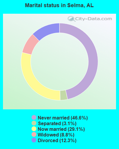
- Never married: 46.6%
- Now married: 29.1%
- Separated: 3.1%
- Widowed: 8.8%
- Divorced: 12.3%
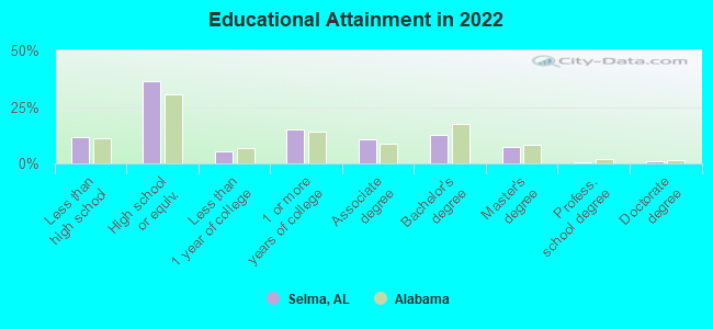
For population 25 years and over in Selma:
- High school or higher: 87.0%
- Bachelor's degree or higher: 19.7%
- Graduate or professional degree: 7.8%
- Unemployed: 12.2%
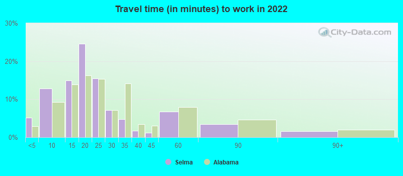
- Mean travel time to work (commute): 22.5 minutes
| Here: | 10.5 |
| Alabama average: | 11.5 |
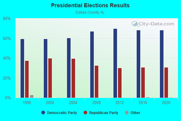
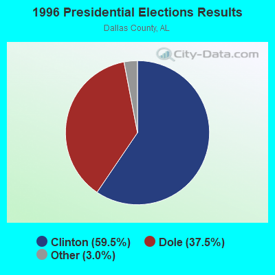
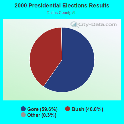
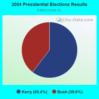

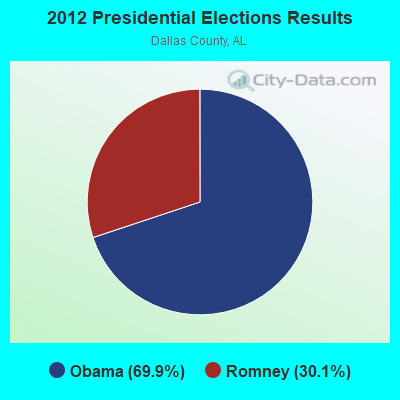
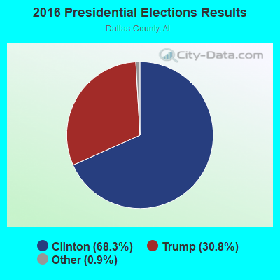
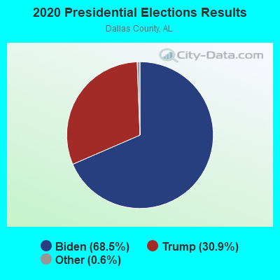
Graphs represent county-level data. Detailed 2008 Election Results
Religion statistics for Selma, AL (based on Dallas County data)
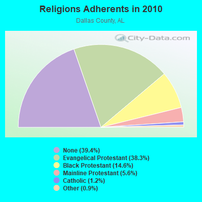
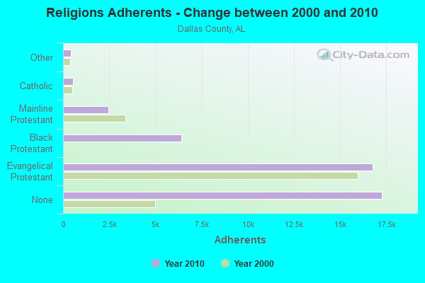
| Religion | Adherents | Congregations |
|---|---|---|
| Evangelical Protestant | 16,764 | 73 |
| Black Protestant | 6,398 | 34 |
| Mainline Protestant | 2,438 | 26 |
| Catholic | 536 | 2 |
| Other | 410 | 5 |
| None | 17,274 | - |
Food Environment Statistics:
| This county: | 2.56 / 10,000 pop. |
| Alabama: | 1.89 / 10,000 pop. |
| Here: | 0.23 / 10,000 pop. |
| Alabama: | 0.20 / 10,000 pop. |
| Dallas County: | 0.93 / 10,000 pop. |
| State: | 0.65 / 10,000 pop. |
| Dallas County: | 9.54 / 10,000 pop. |
| Alabama: | 6.32 / 10,000 pop. |
| Here: | 3.95 / 10,000 pop. |
| Alabama: | 5.75 / 10,000 pop. |
| Here: | 15.1% |
| Alabama: | 11.8% |
| Dallas County: | 41.2% |
| State: | 31.7% |
| Dallas County: | 8.9% |
| Alabama: | 13.5% |
Health and Nutrition:
| Selma: | 47.9% |
| Alabama: | 49.0% |
| This city: | 44.0% |
| Alabama: | 45.7% |
| Selma: | 29.9 |
| Alabama: | 28.9 |
| Here: | 20.8% |
| Alabama: | 20.7% |
| Selma: | 13.9% |
| Alabama: | 11.0% |
| Selma: | 6.7 |
| State: | 6.8 |
| Selma: | 36.0% |
| Alabama: | 34.4% |
| Here: | 52.2% |
| Alabama: | 55.2% |
| Selma: | 80.2% |
| State: | 79.3% |
More about Health and Nutrition of Selma, AL Residents
| Local government employment and payroll (March 2022) | |||||
| Function | Full-time employees | Monthly full-time payroll | Average yearly full-time wage | Part-time employees | Monthly part-time payroll |
|---|---|---|---|---|---|
| Police Protection - Officers | 45 | $144,002 | $38,401 | 0 | $0 |
| Firefighters | 45 | $102,028 | $27,207 | 0 | $0 |
| Solid Waste Management | 41 | $54,453 | $15,937 | 0 | $0 |
| Water Supply | 38 | $119,560 | $37,756 | 2 | $3,662 |
| Sewerage | 17 | $36,804 | $25,979 | 0 | $0 |
| Police - Other | 15 | $21,686 | $17,349 | 0 | $0 |
| Housing and Community Development (Local) | 15 | $13,345 | $10,676 | 0 | $0 |
| Streets and Highways | 15 | $33,411 | $26,729 | 0 | $0 |
| Parks and Recreation | 12 | $15,802 | $15,802 | 0 | $0 |
| Financial Administration | 10 | $22,037 | $26,444 | 0 | $0 |
| Other Government Administration | 8 | $19,891 | $29,837 | 0 | $0 |
| Local Libraries | 8 | $13,155 | $19,733 | 0 | $0 |
| Fire - Other | 6 | $15,554 | $31,108 | 0 | $0 |
| Correction | 5 | $6,288 | $15,091 | 0 | $0 |
| Judicial and Legal | 5 | $9,793 | $23,503 | 0 | $0 |
| Health | 4 | $6,074 | $18,222 | 0 | $0 |
| Other and Unallocable | 0 | $0 | 1 | $722 | |
| Totals for Government | 289 | $633,883 | $26,320 | 3 | $4,384 |
Selma government finances - Expenditure in 2021 (per resident):
- Construction - General - Other: $497,000 ($29.20)
Sewerage: $349,000 ($20.50)
Water Utilities: $302,000 ($17.74)
- Current Operations - General - Other: $6,518,000 ($382.89)
Police Protection: $4,912,000 ($288.55)
Local Fire Protection: $3,069,000 ($180.29)
Regular Highways: $2,323,000 ($136.46)
Sewerage: $2,038,000 ($119.72)
Water Utilities: $1,984,000 ($116.55)
Central Staff Services: $1,492,000 ($87.65)
Parks and Recreation: $853,000 ($50.11)
Judicial and Legal Services: $800,000 ($47.00)
Financial Administration: $589,000 ($34.60)
General Public Buildings: $579,000 ($34.01)
Miscellaneous Commercial Activities - Other: $490,000 ($28.78)
Protective Inspection and Regulation - Other: $332,000 ($19.50)
Solid Waste Management: $204,000 ($11.98)
Health - Other: $173,000 ($10.16)
- General - Interest on Debt: $1,192,000 ($70.02)
- Intergovernmental to Local - Other - Correctional Institutions: $200,000 ($11.75)
Other - Libraries: $184,000 ($10.81)
Other - Health - Other: $42,000 ($2.47)
- Other Capital Outlay - Local Fire Protection: $171,000 ($10.05)
Sewerage: $96,000 ($5.64)
Water Utilities: $93,000 ($5.46)
General - Other: $86,000 ($5.05)
Police Protection: $42,000 ($2.47)
Solid Waste Management: $25,000 ($1.47)
Regular Highways: $24,000 ($1.41)
Miscellaneous Commercial Activities - Other: $20,000 ($1.17)
- Water Utilities - Interest on Debt: $260,000 ($15.27)
Selma government finances - Revenue in 2021 (per resident):
- Charges - Sewerage: $2,655,000 ($155.97)
Solid Waste Management: $93,000 ($5.46)
Other: $38,000 ($2.23)
Miscellaneous Commercial Activities: $17,000 ($1.00)
- Miscellaneous - General Revenue - Other: $942,000 ($55.34)
Fines and Forfeits: $351,000 ($20.62)
Interest Earnings: $17,000 ($1.00)
- Revenue - Water Utilities: $2,751,000 ($161.60)
- State Intergovernmental - Other: $1,634,000 ($95.99)
General Local Government Support: $343,000 ($20.15)
Health and Hospitals: $161,000 ($9.46)
- Tax - General Sales and Gross Receipts: $13,364,000 ($785.06)
Other License: $3,634,000 ($213.48)
Property: $2,979,000 ($175.00)
Motor Fuels Sales: $997,000 ($58.57)
Other Selective Sales: $443,000 ($26.02)
Tobacco Products Sales: $282,000 ($16.57)
Alcoholic Beverage Sales: $124,000 ($7.28)
Selma government finances - Debt in 2021 (per resident):
- Long Term Debt - Beginning Outstanding - Unspecified Public Purpose: $21,210,000 ($1245.96)
Outstanding Unspecified Public Purpose: $20,035,000 ($1176.94)
Retired Unspecified Public Purpose: $1,175,000 ($69.02)
Selma government finances - Cash and Securities in 2021 (per resident):
- Bond Funds - Cash and Securities: $3,525,000 ($207.07)
- Other Funds - Cash and Securities: $8,920,000 ($524.00)
- Sinking Funds - Cash and Securities: $3,770,000 ($221.47)
| Businesses in Selma, AL | ||||
| Name | Count | Name | Count | |
|---|---|---|---|---|
| AT&T | 2 | KFC | 1 | |
| Advance Auto Parts | 1 | La-Z-Boy | 1 | |
| AutoZone | 1 | Lane Furniture | 1 | |
| Burger King | 1 | Little Caesars Pizza | 1 | |
| CVS | 1 | McDonald's | 2 | |
| Chevrolet | 1 | Nike | 8 | |
| Church's Chicken | 1 | Papa John's Pizza | 1 | |
| Comfort Inn | 1 | Payless | 1 | |
| Domino's Pizza | 1 | Pizza Hut | 1 | |
| FedEx | 2 | Popeyes | 1 | |
| Firestone Complete Auto Care | 1 | RadioShack | 1 | |
| Foot Locker | 1 | SONIC Drive-In | 1 | |
| Ford | 1 | Sears | 1 | |
| GNC | 1 | Subway | 4 | |
| GameStop | 1 | Taco Bell | 1 | |
| Goodwill | 6 | True Value | 1 | |
| H&R Block | 1 | U-Haul | 4 | |
| Hardee's | 1 | UPS | 2 | |
| Hilton | 1 | Vans | 1 | |
| Holiday Inn | 1 | Walgreens | 1 | |
| Honda | 1 | Walmart | 1 | |
| JCPenney | 1 | YMCA | 2 | |
Strongest AM radio stations in Selma:
- WHBB (1490 AM; 1 kW; SELMA, AL; Owner: BROADSOUTH COMMUNICATIONS, INC.)
- WMRK (1340 AM; 1 kW; SELMA, AL; Owner: ALEXANDER B/C CO. INC.)
- WJOX (690 AM; 50 kW; BIRMINGHAM, AL; Owner: CITADEL BROADCASTING COMPANY)
- WJUS (1310 AM; 5 kW; MARION, AL; Owner: GRACE BAPTIST TEMPLE CHURCH)
- WDJC (850 AM; 50 kW; BIRMINGHAM, AL; Owner: KIMTRON, INC.)
- WAPI (1070 AM; 50 kW; BIRMINGHAM, AL; Owner: CITADEL BROADCASTING COMPANY)
- WMSP (740 AM; 10 kW; MONTGOMERY, AL; Owner: CUMULUS LICENSING CORP.)
- WACV (1170 AM; 10 kW; MONTGOMERY, AL; Owner: MONTGOMERY BROADCAST PROPERTIES, LTD)
- WASG (550 AM; 25 kW; ATMORE, AL; Owner: 550 AM, INC)
- WNSI (810 AM; 50 kW; JACKSONVILLE, AL; Owner: UNITED BROADCASTING NETWORK, INC.)
- WKNG (1060 AM; daytime; 50 kW; TALLAPOOSA, GA; Owner: WKNG, INC.)
- WGST (640 AM; 50 kW; ATLANTA, GA; Owner: CITICASTERS LICENSES, L.P.)
- WSJC (810 AM; 50 kW; MAGEE, MS; Owner: FAMILY TALK RADIO)
Strongest FM radio stations in Selma:
- WALX (100.9 FM; SELMA, AL; Owner: ALEXANDER BROADCASTING COMPANY, INC.)
- WDXX (100.1 FM; SELMA, AL; Owner: BROADSOUTH COMMUNICATIONS, INC.)
- WAQU (91.1 FM; SELMA, AL; Owner: AMERICAN FAMILY ASSOCIATION)
- W232AN (94.3 FM; SELMA, AL; Owner: THE MOODY BIBLE INSTITUTE OF CHICAGO)
- WJAM-FM (97.3 FM; ORRVILLE, AL; Owner: SCOTT COMMUNICATIONS, INC.)
- WAPR (88.3 FM; SELMA, AL; Owner: UA-ASU-TSU EDUCATIONAL RADIO CORP.)
- WBFZ (105.3 FM; SELMA, AL; Owner: IMANI COMMUNICATIONS CORPORATION, INC)
- WLWI-FM (92.3 FM; MONTGOMERY, AL; Owner: CUMULUS LICENSING CORP.)
- WQLD (104.3 FM; LUVERNE, AL; Owner: CAPSTAR TX LIMITED PARTNERSHIP)
- WZHT (105.7 FM; TROY, AL; Owner: CAPSTAR TX LIMITED PARTNERSHIP)
- WMXS (103.3 FM; MONTGOMERY, AL; Owner: CUMULUS LICENSING CORP.)
- WVFG (107.5 FM; UNIONTOWN, AL; Owner: CHARLES E. JONES, JR.)
TV broadcast stations around Selma:
- WBIH (Channel 29; SELMA, AL; Owner: FLINN BROADCASTING CORPORATION)
- WAKA (Channel 8; SELMA, AL; Owner: ALABAMA BROADCASTING PARTNERS)
- W24CK (Channel 24; SELMA, AL; Owner: TRINITY BROADCASTING NETWORK)
- WNCF (Channel 32; MONTGOMERY, AL; Owner: CHANNEL 32 MONTGOMERY LLC)
- WRJM-TV (Channel 67; TROY, AL; Owner: JOSIE PARK BROADCASTING, INC.)
- WSFA (Channel 12; MONTGOMERY, AL; Owner: LIBCO, INC.)
Medal of Honor Recipients
Medal of Honor Recipient born in Selma: Howard Walter Gilmore.
- National Bridge Inventory (NBI) Statistics
- 37Number of bridges
- 574ft / 175mTotal length
- $65,024,000Total costs
- 237,433Total average daily traffic
- 27,280Total average daily truck traffic
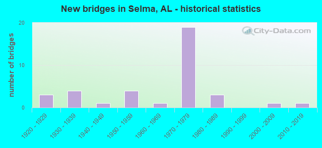
- New bridges - historical statistics
- 31920-1929
- 41930-1939
- 11940-1949
- 41950-1959
- 11960-1969
- 191970-1979
- 31980-1989
- 12000-2009
- 12010-2019
FCC Registered Antenna Towers: 278 (See the full list of FCC Registered Antenna Towers)
FCC Registered Commercial Land Mobile Towers: 5 (See the full list of FCC Registered Commercial Land Mobile Towers in Selma, AL)
FCC Registered Private Land Mobile Towers: 8 (See the full list of FCC Registered Private Land Mobile Towers)
FCC Registered Broadcast Land Mobile Towers: 53 (See the full list of FCC Registered Broadcast Land Mobile Towers)
FCC Registered Microwave Towers: 41 (See the full list of FCC Registered Microwave Towers in this town)
FCC Registered Paging Towers: 5 (See the full list of FCC Registered Paging Towers)
FCC Registered Maritime Coast & Aviation Ground Towers: 6 (See the full list of FCC Registered Maritime Coast & Aviation Ground Towers)
FCC Registered Amateur Radio Licenses: 46 (See the full list of FCC Registered Amateur Radio Licenses in Selma)
FAA Registered Aircraft: 12 (See the full list of FAA Registered Aircraft in Selma)
2003 - 2018 National Fire Incident Reporting System (NFIRS) incidents
- Fire incident types reported to NFIRS in Selma, AL
- 1,26742.1%Structure Fires
- 1,01033.5%Outside Fires
- 70323.3%Mobile Property/Vehicle Fires
- 331.1%Other
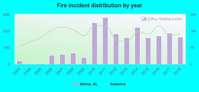 Based on the data from the years 2003 - 2018 the average number of fire incidents per year is 188. The highest number of fires - 421 took place in 2011, and the least - 0 in 2004. The data has a rising trend.
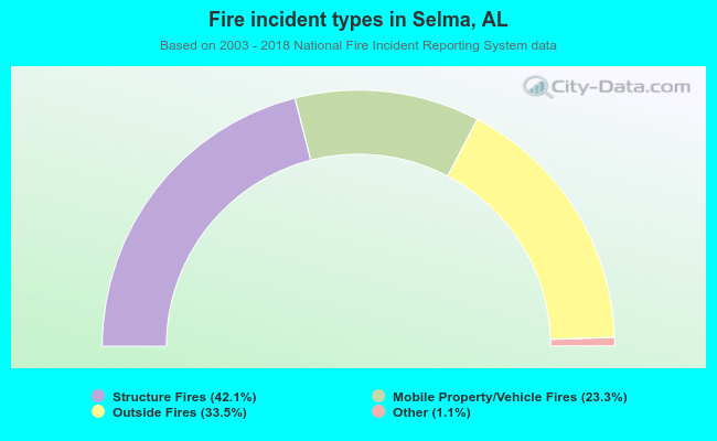 When looking into fire subcategories, the most reports belonged to: Structure Fires (42.1%), and Outside Fires (33.5%).
Fire-safe hotels and motels in Selma, Alabama:
- America's Best Value Inn, 1915 W Highland Ave, Selma, Alabama 36701 , Phone: (334) 872-1900, Fax: (334) 872-6635
- Craig Motel, 1134 Hwy 80 E, Selma, Alabama 36071 , Phone: (334) 875-3150
- Travelers Inn Of Selma Inc, 2006 W Highland Ave, Selma, Alabama 36701 , Phone: (334) 875-1200
- Budget Inn, 601 Highland Ave, Selma, Alabama 36701 , Phone: (334) 872-3451
- Comfort Inn, 1812 Hwy 14 E, Selma, Alabama 36701 , Phone: (334) 875-5700, Fax: (334) 874-7955
- Ramada Inn Selma, 1710 W Highland Ave, Selma, Alabama 36701 , Phone: (334) 872-0461, Fax: (334) 872-0461
- St James Hotel, 1200 Water Ave, Selma, Alabama 36701 , Phone: (334) 872-3234, Fax: (334) 872-7275
- Hampton Inn, 2200 W Highland Ave, Selma, Alabama 36701 , Phone: (334) 876-9995, Fax: (334) 876-9993
- 3 other hotels and motels
| Most common first names in Selma, AL among deceased individuals | ||
| Name | Count | Lived (average) |
|---|---|---|
| Mary | 433 | 78.2 years |
| James | 368 | 71.4 years |
| Willie | 312 | 72.1 years |
| John | 307 | 73.6 years |
| William | 296 | 72.2 years |
| Robert | 210 | 70.7 years |
| Annie | 200 | 76.0 years |
| George | 140 | 73.4 years |
| Henry | 127 | 72.0 years |
| Charles | 106 | 66.1 years |
| Most common last names in Selma, AL among deceased individuals | ||
| Last name | Count | Lived (average) |
|---|---|---|
| Smith | 306 | 73.9 years |
| Johnson | 208 | 71.7 years |
| Williams | 195 | 74.7 years |
| Jones | 179 | 75.3 years |
| Moore | 153 | 73.3 years |
| Brown | 151 | 74.2 years |
| Harris | 143 | 74.3 years |
| Jackson | 139 | 71.1 years |
| Davis | 136 | 73.3 years |
| Thomas | 122 | 73.3 years |
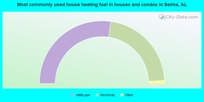
- 54.5%Utility gas
- 44.1%Electricity
- 1.2%Bottled, tank, or LP gas
- 0.3%No fuel used
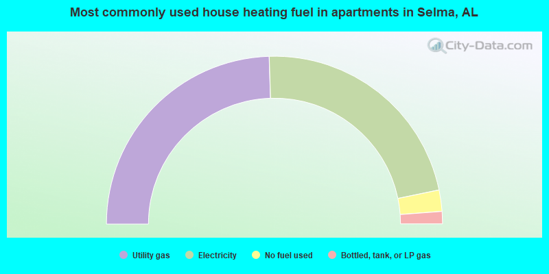
- 49.0%Utility gas
- 44.5%Electricity
- 4.1%No fuel used
- 2.4%Bottled, tank, or LP gas
Selma compared to Alabama state average:
- Median household income below state average.
- Median house value below state average.
- Black race population percentage above state average.
- Hispanic race population percentage below state average.
- Median age significantly below state average.
- Foreign-born population percentage below state average.
- Renting percentage above state average.
- Length of stay since moving in significantly above state average.
- House age above state average.
Selma on our top lists:
- #25 on the list of "Top 101 cities with the highest percentage of single-parent households, population 5,000+"
- #27 on the list of "Top 101 cities with largest percentage of females in occupations: installation, maintenance, and repair occupations (population 5,000+)"
- #43 on the list of "Top 101 cities with the highest city-data.com crime index, excludes tourist destinations and others with a lot of outsiders visiting based on city industries data (population 5,000+)"
- #49 on the list of "Top 101 cities with the highest number of burglaries per 100,000 residents, excludes tourist destinations and others with a lot of outsiders visiting based on city industries data (population 5,000+)"
- #80 on the list of "Top 101 cities with largest percentage of males in industries: other services, except public administration (population 5,000+)"
- #83 on the list of "Top 100 cities with the largest percentage of females (pop. 5,000+)"
- #84 on the list of "Top 100 least-safe cities (highest city-data.com crime index) (pop. 5,000+)"

|
|
Total of 7 patent applications in 2008-2024.