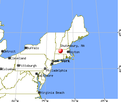
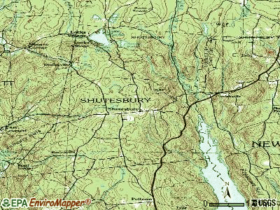
Shutesbury, Massachusetts
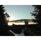
Submit your own pictures of this town and show them to the world
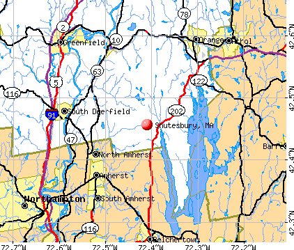
- OSM Map
- General Map
- Google Map
- MSN Map
Population change since 2000: -2.2%
 |
| Males: 845 | |
| Females: 926 |
| Median resident age: | 45.6 years |
| Massachusetts median age: | 39.2 years |
Zip codes: 01072.
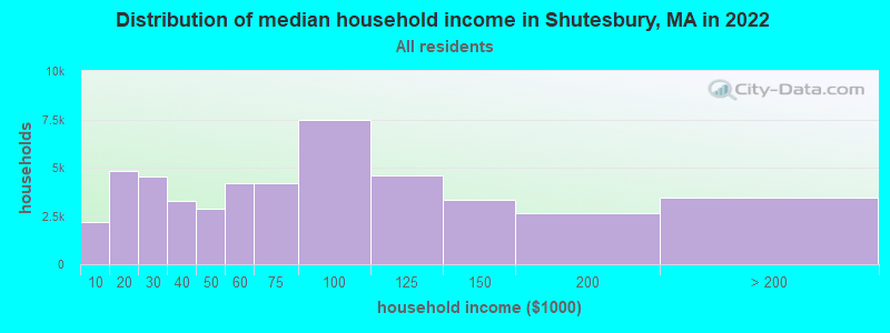
| Shutesbury: | $104,228 |
| MA: | $94,488 |
Estimated per capita income in 2022: $47,844 (it was $26,260 in 2000)
Shutesbury town income, earnings, and wages data
Estimated median house or condo value in 2022: $402,847 (it was $162,100 in 2000)
| Shutesbury: | $402,847 |
| MA: | $534,700 |
Mean prices in 2022: all housing units: $313,377; detached houses: $324,224; townhouses or other attached units: $284,225; in 2-unit structures: $287,978; in 3-to-4-unit structures: $183,938; in 5-or-more-unit structures: $249,762; mobile homes: $62,200
Detailed information about poverty and poor residents in Shutesbury, MA


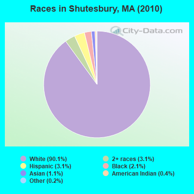
- 1,59590.1%White alone
- 553.1%Two or more races
- 553.1%Hispanic
- 372.1%Black alone
- 191.1%Asian alone
- 70.4%American Indian alone
- 30.2%Other race alone
Races in Shutesbury detailed stats: ancestries, foreign born residents, place of birth
 Recent articles from our blog. Our writers, many of them Ph.D. graduates or candidates, create easy-to-read articles on a wide variety of topics.


 | Massachusetts is America's Smartest State (104 replies) |
| Ugliest or most annoying billboards in the region (34 replies) |
| Pioneer Valley: Wood Stoves + Well/Spring Water? (31 replies) |
| Winter Commute to Northampton (24 replies) |
| Which Franklin county town for young family? (12 replies) |
| How Much Massachusetts Households Make Per Year: Census Data (37 replies) |
Latest news from Shutesbury, MA collected exclusively by city-data.com from local newspapers, TV, and radio stations
Ancestries: English (22.6%), Irish (18.6%), German (14.0%), Polish (11.3%), Italian (8.3%), French (6.6%).
Current Local Time: EST time zone
Incorporated in 1761
Elevation: 1225 feet
Land area: 26.6 square miles.
Population density: 67 people per square mile (very low).
50 residents are foreign born (0.9% Europe, 0.6% North America, 0.5% Asia, 0.4% Latin America).
| This town: | 2.8% |
| Massachusetts: | 12.2% |
| Shutesbury town: | 1.9% ($3,120) |
| Massachusetts: | 1.3% ($2,336) |
Nearest city with pop. 50,000+: Chicopee, MA  (21.0 miles , pop. 54,653).
Nearest city with pop. 200,000+: Boston, MA (69.1 miles , pop. 589,141).
Nearest city with pop. 1,000,000+: Bronx, NY (133.6 miles , pop. 1,332,650).
Nearest cities:
), ), ), )Latitude: 42.45 N, Longitude: 72.43 W
Area code commonly used in this area: 413

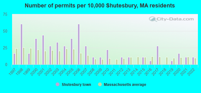
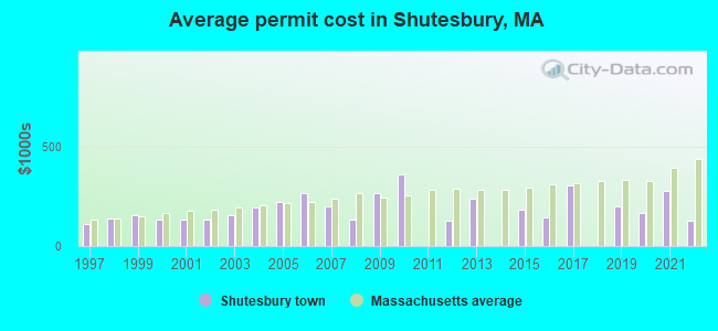
Single-family new house construction building permits:
- 2022: 2 buildings, average cost: $125,000
- 2021: 2 buildings, average cost: $275,000
- 2020: 3 buildings, average cost: $166,700
- 2019: 1 building, cost: $200,000
- 2017: 5 buildings, average cost: $303,000
- 2016: 1 building, cost: $142,000
- 2015: 2 buildings, average cost: $183,500
- 2013: 2 buildings, average cost: $237,500
- 2012: 2 buildings, average cost: $125,000
- 2010: 4 buildings, average cost: $362,300
- 2009: 2 buildings, average cost: $262,700
- 2008: 2 buildings, average cost: $131,700
- 2007: 5 buildings, average cost: $196,900
- 2006: 11 buildings, average cost: $264,500
- 2005: 7 buildings, average cost: $220,000
- 2004: 5 buildings, average cost: $193,200
- 2003: 6 buildings, average cost: $157,300
- 2002: 5 buildings, average cost: $129,800
- 2001: 8 buildings, average cost: $130,600
- 2000: 7 buildings, average cost: $134,200
- 1999: 3 buildings, average cost: $155,900
- 1998: 11 buildings, average cost: $136,800
- 1997: 3 buildings, average cost: $109,400
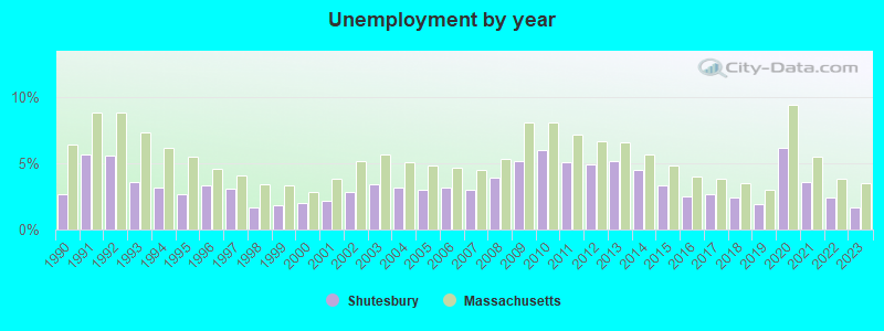
| Here: | 1.7% |
| Massachusetts: | 3.5% |
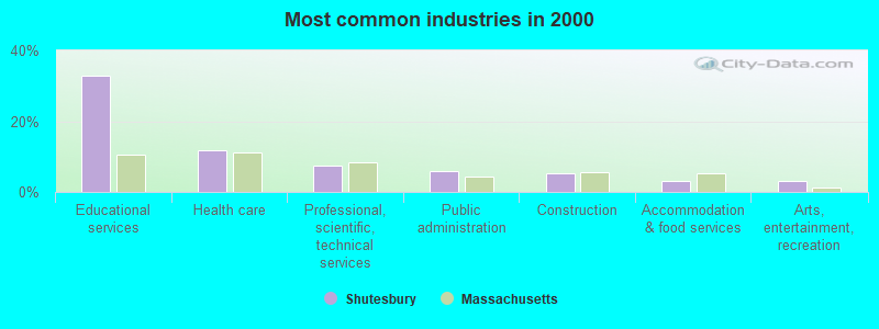
- Educational services (32.7%)
- Health care (11.9%)
- Professional, scientific, technical services (7.3%)
- Public administration (5.8%)
- Construction (5.4%)
- Accommodation & food services (3.0%)
- Arts, entertainment, recreation (3.0%)
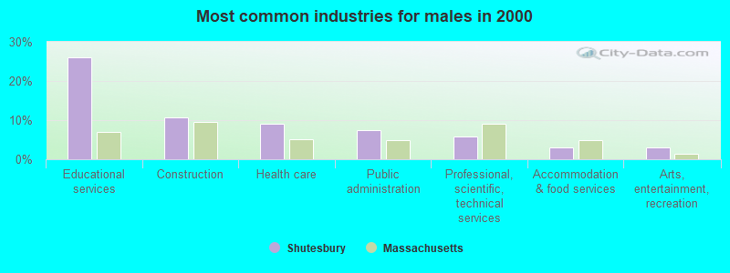
- Educational services (26.0%)
- Construction (10.6%)
- Health care (9.1%)
- Public administration (7.5%)
- Professional, scientific, technical services (5.9%)
- Accommodation & food services (2.9%)
- Arts, entertainment, recreation (2.9%)
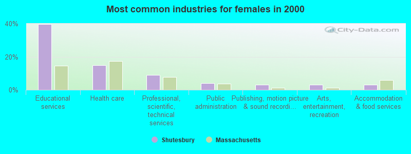
- Educational services (39.8%)
- Health care (14.8%)
- Professional, scientific, technical services (8.9%)
- Public administration (4.0%)
- Publishing, motion picture & sound recording industries (3.0%)
- Arts, entertainment, recreation (3.0%)
- Accommodation & food services (3.0%)
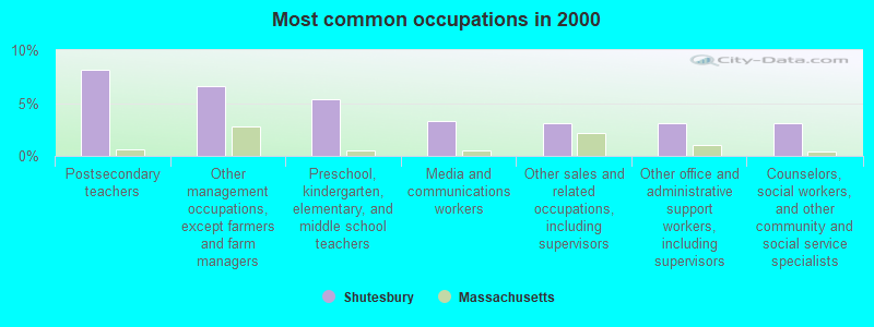
- Postsecondary teachers (8.1%)
- Other management occupations, except farmers and farm managers (6.6%)
- Preschool, kindergarten, elementary, and middle school teachers (5.4%)
- Media and communications workers (3.3%)
- Other sales and related occupations, including supervisors (3.1%)
- Other office and administrative support workers, including supervisors (3.1%)
- Counselors, social workers, and other community and social service specialists (3.1%)
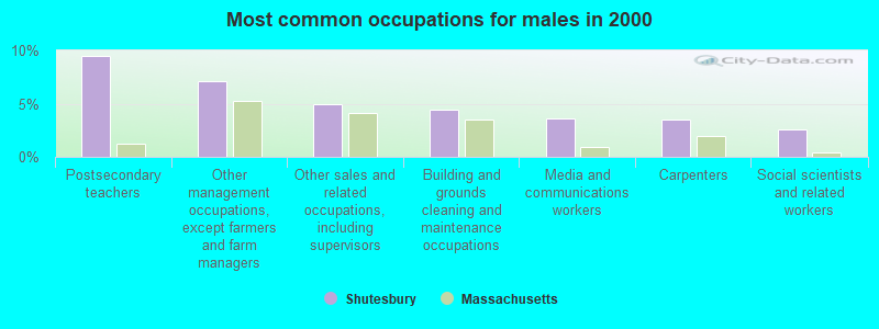
- Postsecondary teachers (9.5%)
- Other management occupations, except farmers and farm managers (7.1%)
- Other sales and related occupations, including supervisors (4.9%)
- Building and grounds cleaning and maintenance occupations (4.4%)
- Media and communications workers (3.7%)
- Carpenters (3.5%)
- Social scientists and related workers (2.6%)
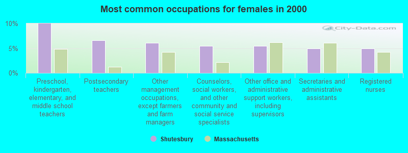
- Preschool, kindergarten, elementary, and middle school teachers (10.0%)
- Postsecondary teachers (6.6%)
- Other management occupations, except farmers and farm managers (6.1%)
- Counselors, social workers, and other community and social service specialists (5.5%)
- Other office and administrative support workers, including supervisors (5.5%)
- Secretaries and administrative assistants (4.9%)
- Registered nurses (4.9%)
Average climate in Shutesbury, Massachusetts
Based on data reported by over 4,000 weather stations


(lower is better)
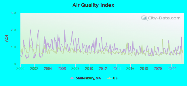
Air Quality Index (AQI) level in 2022 was 74.4. This is about average.
| City: | 74.4 |
| U.S.: | 72.6 |
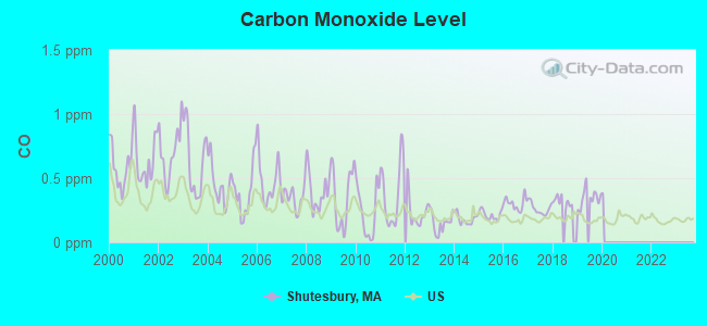
Carbon Monoxide (CO) [ppm] level in 2019 was 0.346. This is worse than average. Closest monitor was 20.1 miles away from the city center.
| City: | 0.346 |
| U.S.: | 0.251 |
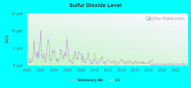
Sulfur Dioxide (SO2) [ppb] level in 2022 was 0.203. This is significantly better than average. Closest monitor was 10.5 miles away from the city center.
| City: | 0.203 |
| U.S.: | 1.515 |
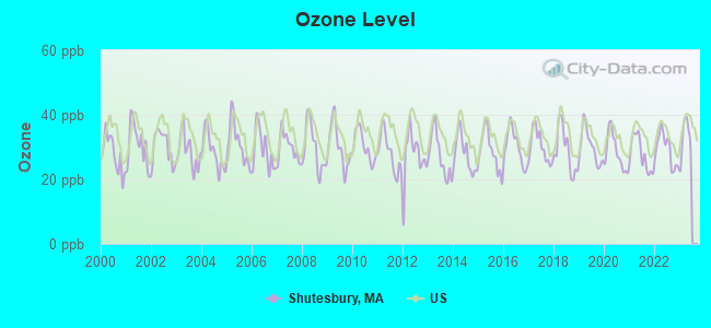
Ozone [ppb] level in 2022 was 29.1. This is about average. Closest monitor was 5.8 miles away from the city center.
| City: | 29.1 |
| U.S.: | 33.3 |
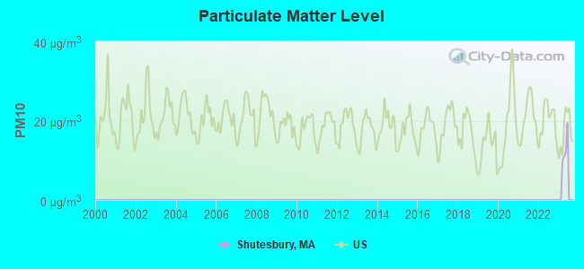
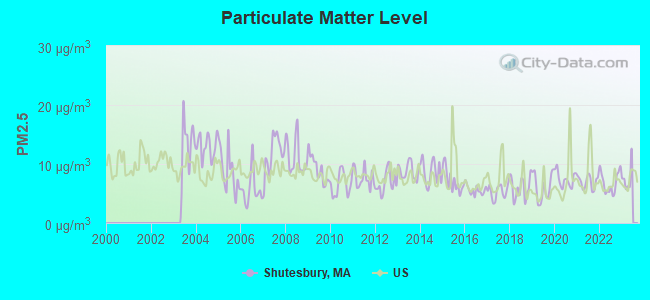
Particulate Matter (PM2.5) [µg/m3] level in 2022 was 6.88. This is about average. Closest monitor was 11.6 miles away from the city center.
| City: | 6.88 |
| U.S.: | 8.11 |
Tornado activity:
Shutesbury-area historical tornado activity is above Massachusetts state average. It is 9% smaller than the overall U.S. average.
On 6/9/1953, a category F4 (max. wind speeds 207-260 mph) tornado 13.4 miles away from the Shutesbury town center killed 90 people and injured 1228 people and caused between $50,000,000 and $500,000,000 in damages.
On 10/3/1979, a category F4 tornado 30.9 miles away from the town center killed 3 people and injured 500 people and caused between $50,000,000 and $500,000,000 in damages.
Earthquake activity:
Shutesbury-area historical earthquake activity is significantly above Massachusetts state average. It is 70% smaller than the overall U.S. average.On 10/7/1983 at 10:18:46, a magnitude 5.3 (5.1 MB, 5.3 LG, 5.1 ML, Class: Moderate, Intensity: VI - VII) earthquake occurred 141.7 miles away from the city center
On 4/20/2002 at 10:50:47, a magnitude 5.3 (5.3 ML, Depth: 3.0 mi) earthquake occurred 156.1 miles away from the city center
On 4/20/2002 at 10:50:47, a magnitude 5.2 (5.2 MB, 4.2 MS, 5.2 MW, 5.0 MW) earthquake occurred 155.0 miles away from Shutesbury center
On 1/19/1982 at 00:14:42, a magnitude 4.7 (4.5 MB, 4.7 MD, 4.5 LG, Class: Light, Intensity: IV - V) earthquake occurred 83.9 miles away from Shutesbury center
On 10/16/2012 at 23:12:25, a magnitude 4.7 (4.7 ML, Depth: 10.0 mi) earthquake occurred 119.8 miles away from Shutesbury center
On 10/2/1994 at 11:27:22, a magnitude 3.7 (3.5 LG, 3.7 LG, Depth: 6.2 mi, Class: Light, Intensity: II - III) earthquake occurred 10.6 miles away from the city center
Magnitude types: regional Lg-wave magnitude (LG), body-wave magnitude (MB), duration magnitude (MD), local magnitude (ML), surface-wave magnitude (MS), moment magnitude (MW)
Natural disasters:
The number of natural disasters in Franklin County (20) is greater than the US average (15).Major Disasters (Presidential) Declared: 9
Emergencies Declared: 10
Causes of natural disasters: Floods: 5, Storms: 5, Hurricanes: 4, Snowstorms: 4, Winter Storms: 3, Blizzards: 2, Snows: 2, Snowfall: 1, Tropical Storm: 1, Wind: 1, Other: 1 (Note: some incidents may be assigned to more than one category).
Hospitals and medical centers near Shutesbury:
- HOSPICE OF THE FISHER HOME (Hospital, about 6 miles away; AMHERST, MA)
- CENTER FOR EXTENDED CARE AT AMHERST (Nursing Home, about 8 miles away; AMHERST, MA)
- COZY CORNER NURSING AND REHABILITATION CENTER (Nursing Home, about 8 miles away; SUNDERLAND, MA)
- HADLEY AT ELAINE CARE AND REHABILITATION CENTER (Nursing Home, about 9 miles away; HADLEY, MA)
- QUABBIN VALLEY HEALTHCARE (Nursing Home, about 12 miles away; ATHOL, MA)
- GENTIVA HEALTH SERVICES (Home Health Center, about 13 miles away; GREENFIELD, MA)
- HOME CARE PRN INC (Home Health Center, about 13 miles away; GREENFIELD, MA)
Colleges/universities with over 2000 students nearest to Shutesbury:
- University of Massachusetts-Amherst (about 7 miles; Amherst, MA; Full-time enrollment: 26,583)
- Smith College (about 14 miles; Northampton, MA; FT enrollment: 3,549)
- Mount Holyoke College (about 16 miles; South Hadley, MA; FT enrollment: 2,573)
- Holyoke Community College (about 21 miles; Holyoke, MA; FT enrollment: 4,911)
- Western New England University (about 24 miles; Springfield, MA; FT enrollment: 3,477)
- American International College (about 25 miles; Springfield, MA; FT enrollment: 2,733)
- Springfield College (about 25 miles; Springfield, MA; FT enrollment: 3,144)
Public elementary/middle school in Shutesbury:
- SHUTESBURY ELEMENTARY (Students: 155, Location: 23 WEST PELHAM RD, Grades: PK-6)
Points of interest:
Notable location: Shutesbury Fire Department (A). Display/hide its location on the map
Churches in Shutesbury include: Shutesbury Community Church (A), North Leverett Baptist Church (B). Display/hide their locations on the map
Cemeteries: Shutesbury Cemetery (1), West Cemetery (2). Display/hide their locations on the map
Lakes and reservoirs: Lake Wyola (A), Dudleys Pond (B), Leonards Pond (C), Ames Pond (D), Atkins Reservoir (E), Baker Reservoir (F), Lake Wyola Reservoir (G). Display/hide their locations on the map
Streams, rivers, and creeks: Town Farm Brook (A), Tyler Brook (B), Baker Brook (C), Cobb Brook (D), Dean Brook (E), Keyup Brook (F), Nurse Brook (G), Osgood Brook (H), Rocky Run (I). Display/hide their locations on the map
Birthplace of: Herbert Baxter Adams - Educator and historian, Paul Dillingham - Politician.
| This town: | 2.5 people |
| Massachusetts: | 2.5 people |
| This town: | 67.6% |
| Whole state: | 63.0% |
| This town: | 9.4% |
| Whole state: | 7.0% |
Likely homosexual households (counted as self-reported same-sex unmarried-partner households)
- Lesbian couples: 2.5% of all households
- Gay men: 0.0% of all households
| This town: | 3.8% |
| Whole state: | 9.3% |
| This town: | 2.0% |
| Whole state: | 4.4% |
For population 15 years and over in Shutesbury:
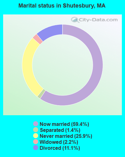
- Never married: 25.9%
- Now married: 59.4%
- Separated: 1.4%
- Widowed: 2.2%
- Divorced: 11.1%
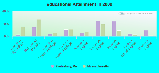
For population 25 years and over in Shutesbury:
- High school or higher: 97.5%
- Bachelor's degree or higher: 62.7%
- Graduate or professional degree: 38.1%
- Unemployed: 2.7%
- Mean travel time to work (commute): 29.2 minutes
| Here: | 10.5 |
| Massachusetts average: | 13.1 |


Graphs represent county-level data. Detailed 2008 Election Results
Religion statistics for Shutesbury, MA (based on Franklin County data)


| Religion | Adherents | Congregations |
|---|---|---|
| Catholic | 16,509 | 15 |
| Mainline Protestant | 4,617 | 38 |
| Evangelical Protestant | 2,079 | 20 |
| Other | 1,580 | 21 |
| None | 46,587 | - |
Food Environment Statistics:
| Franklin County: | 3.63 / 10,000 pop. |
| Massachusetts: | 1.98 / 10,000 pop. |
| Franklin County: | 0.14 / 10,000 pop. |
| Massachusetts: | 0.05 / 10,000 pop. |
| This county: | 1.67 / 10,000 pop. |
| Massachusetts: | 2.22 / 10,000 pop. |
| Franklin County: | 3.21 / 10,000 pop. |
| Massachusetts: | 1.77 / 10,000 pop. |
| This county: | 8.10 / 10,000 pop. |
| Massachusetts: | 8.76 / 10,000 pop. |
| This county: | 7.5% |
| Massachusetts: | 8.1% |
| Franklin County: | 22.2% |
| Massachusetts: | 22.5% |
| This county: | 15.1% |
| Massachusetts: | 16.5% |
Strongest AM radio stations in Shutesbury:
- WNNZ (640 AM; 50 kW; WESTFIELD, MA; Owner: CLEAR CHANNEL BROADCASTING LICENSES, INC.)
- WPNI (1430 AM; 5 kW; AMHERST, MA; Owner: WESTERN MASSACHUSETTS RADIO COMPANY)
- WCRN (830 AM; 50 kW; WORCESTER, MA; Owner: CARTER BROADCASTING CORPORATION)
- WVNE (760 AM; daytime; 25 kW; LEICESTER, MA; Owner: BLOUNT MASSCOM, INC.)
- WIZZ (1520 AM; daytime; 10 kW; GREENFIELD, MA; Owner: P. & M. RADIO, LLC)
- WCAT (700 AM; daytime; 2 kW; ORANGE-ATHOL, MA; Owner: CITADEL BROADCASTING COMPANY)
- WTIC (1080 AM; 50 kW; HARTFORD, CT; Owner: INFINITY RADIO OPERATIONS INC.)
- WRKO (680 AM; 50 kW; BOSTON, MA; Owner: ENTERCOM BOSTON LICENSE, LLC)
- WHYN (560 AM; 5 kW; SPRINGFIELD, MA; Owner: CLEAR CHANNEL BROADCASTING LICENSES, INC.)
- WALE (990 AM; 50 kW; GREENVILLE, RI; Owner: NORTH AMERICAN BROADCASTING CO., INC.)
- WEEI (850 AM; 50 kW; BOSTON, MA; Owner: ENTERCOM BOSTON LICENSE, LLC)
- WKOX (1200 AM; 50 kW; FRAMINGHAM, MA; Owner: CAPSTAR TX LIMITED PARTNERSHIP)
- WBIX (1060 AM; 40 kW; NATICK, MA; Owner: LANGER BROADCASTING CORPORATION)
Strongest FM radio stations in Shutesbury:
- WFCR (88.5 FM; AMHERST, MA; Owner: UNIVERSITY OF MASSACHUSETTS)
- WAMH (89.3 FM; AMHERST, MA; Owner: TRUSTEES OF AMHERST COLLEGE)
- W246AM (97.1 FM; AMHERST, MA; Owner: GREAT NORTHERN RADIO, LLC)
- WHYN-FM (93.1 FM; SPRINGFIELD, MA; Owner: CLEAR CHANNEL BROADCASTING LICENSES, INC.)
- WRNX (100.9 FM; AMHERST, MA; Owner: WESTERN MASSACHUSETTS RADIO COMPANY)
- WPVQ (95.3 FM; GREENFIELD, MA; Owner: GREAT NORTHERN RADIO, L.L.C.)
- WHAI (98.3 FM; GREENFIELD, MA; Owner: SAGA COMMUNICATIONS OF NEW ENGLAND, LLC)
- WAMC-FM (90.3 FM; ALBANY, NY; Owner: WAMC)
- WGAJ (91.7 FM; DEERFIELD, MA; Owner: TRUATEES OF DEERFIELD ACADEMY)
- WLZX (99.3 FM; NORTHAMPTON, MA; Owner: SAGA COMMUNICATIONS OF NEW ENGLAND, LLC)
- WAAF (107.3 FM; WORCESTER, MA; Owner: ENTERCOM BOSTON LICENSE, LLC)
- WRSI (93.9 FM; TURNERS FALLS, MA; Owner: GREAT NORTHERN RADIO, LLC)
- WJDF (97.3 FM; ORANGE, MA; Owner: DEANE BROTHERS BROADCASTING CORP.)
- WMUA (91.1 FM; AMHERST, MA; Owner: UNIVERSITY OF MASSACHUSETTS)
- WAHL (99.9 FM; ATHOL, MA; Owner: CITADEL BROADCASTING COMPANY)
- WYRY (104.9 FM; HINSDALE, NH; Owner: TRI-VALLEY BROADCASTING CORPORATION)
- WEQX (102.7 FM; MANCHESTER, VT; Owner: NORTHSHIRE COMMUNICATIONS, INC.)
- WFEX (92.1 FM; PETERBOROUGH, NH; Owner: FNX BROADCASTING OF NEW HAMPSHIRE LLC)
- WJAN (95.1 FM; SUNDERLAND, VT; Owner: 6 JOHNSON ROAD LICENSES, INC.)
- WSRS (96.1 FM; WORCESTER, MA; Owner: CAPSTAR TX LIMITED PARTNERSHIP)
TV broadcast stations around Shutesbury:
- WYDN (Channel 48; WORCESTER, MA; Owner: EDUCATIONAL PUBLIC TV CORPORATION)
- WUNI (Channel 27; WORCESTER, MA; Owner: ENTRAVISION HOLDINGS, LLC)
- WTIC-TV (Channel 61; HARTFORD, CT; Owner: TRIBUNE TELEVISION COMPANY)
- WUTF (Channel 66; MARLBOROUGH, MA; Owner: TELEFUTURA BOSTON LLC)
- WWLP (Channel 22; SPRINGFIELD, MA; Owner: WWLP BROADCASTING, LLC)
- W67DF (Channel 67; SPRINGFIELD, MA; Owner: TRINITY BROADCASTING NETWORK)
- WGGB-TV (Channel 40; SPRINGFIELD, MA; Owner: WGGB LICENSEE, LLC)
- WGBY-TV (Channel 57; SPRINGFIELD, MA; Owner: WGBH EDUCATIONAL FOUNDATION)
Shutesbury fatal accident list:
Jul 22, 1995 00:41 AM, Prescott, Vehicles: 1, Persons: 2, Fatalities: 1
Oct 26, 1976 04:15 AM, Vehicles: 1, Persons: 1, Fatalities: 1, Drunk persons involved: 1
Oct 26, 1975 04:15 AM, Vehicles: 1, Persons: 1, Fatalities: 1, Drunk persons involved: 1
- National Bridge Inventory (NBI) Statistics
- 1Number of bridges
- 3ft / 0.8mTotal length
- $625,000Total costs
- 200Total average daily traffic
- 2Total average daily truck traffic
- 0Total future (year 21) average daily traffic
FCC Registered Antenna Towers:
4- Ashley Pittman, West Of Wendell Road, Between Ladyslipper Ln And Carver Rd E. (Lat: 42.477750 Lon: -72.417278), Type: 48.8, Structure height: 25011 m, Overall height: 45.7 m, Registrant: Vertex Towers, LLC., Stephen@vertextowers.Com, Suite 205, Wrent-ham, Phone: (617) 817-8564
- Ashley Pittman, West Of Wendell Road, Between Ladyslipper Ln And Carver Rd E. (Lat: 42.477750 Lon: -72.417278), Type: 48.8, Structure height: 25011 m, Overall height: 45.7 m, Registrant: Vertex Towers, LLC., Stephen@vertextowers.Com, Suite 205, Wrent-ham, Phone: (617) 817-8564
- Justin S Wagner, West Of Wendell Road, Between Ladyslipper Ln And Carver Rd E. (Lat: 42.477750 Lon: -72.417278), Type: 48.8, Structure height: 25011 m, Overall height: 45.7 m, Registrant: Vertex Towers, LLC., Stephen@vertextowers.Com, Suite 205, Wrent-ham, Phone: (617) 817-8564
- Justin Wagner, West Of Wendell Road, Between Ladyslipper Ln And Carver Rd E. (Lat: 42.477750 Lon: -72.417278), Type: 48.8, Structure height: 25011 m, Overall height: 45.7 m, Registrant: Vertex Towers, LLC., Stephen@vertextowers.Com, , Sharo-n, Phone: (617) 817-8564
FCC Registered Microwave Towers:
1- SHUTESBURY, Near Intersection Of Wendle & Leverett Road (Lat: 42.451750 Lon: -72.409250), Type: Tower, Structure height: 18 m, Call Sign: WQDI992,
Assigned Frequencies: 942.775 MHz, Grant Date: 09/08/2005, Expiration Date: 09/08/2015, Cancellation Date: 11/14/2015, Certifier: Russell Sienkiewcz, Registrant: New England Communications Systems, Inc., 15 Industrial Park Place, Middletown, CT 06457, Phone: (860) 632-2678, Fax: (860) 613-0559, Email:
FCC Registered Amateur Radio Licenses:
15 (See the full list of FCC Registered Amateur Radio Licenses in Shutesbury)2002 - 2018 National Fire Incident Reporting System (NFIRS) incidents
- Fire incident types reported to NFIRS in Shutesbury, MA
- 8372.2%Structure Fires
- 1613.9%Outside Fires
- 1412.2%Mobile Property/Vehicle Fires
- 21.7%Other
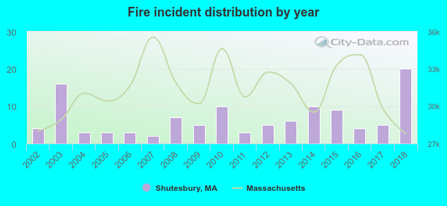 Based on the data from the years 2002 - 2018 the average number of fire incidents per year is 7. The highest number of reported fire incidents - 20 took place in 2018, and the least - 2 in 2007. The data has a rising trend.
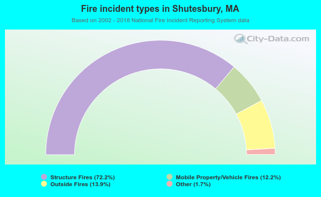 When looking into fire subcategories, the most reports belonged to: Structure Fires (72.2%), and Outside Fires (13.9%).
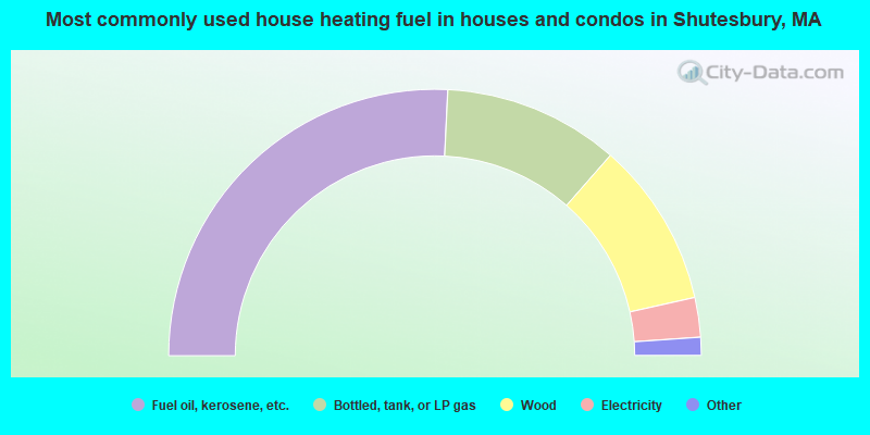
- 51.6%Fuel oil, kerosene, etc.
- 21.4%Bottled, tank, or LP gas
- 20.1%Wood
- 4.8%Electricity
- 1.1%Coal or coke
- 0.7%Other fuel
- 0.4%Solar energy
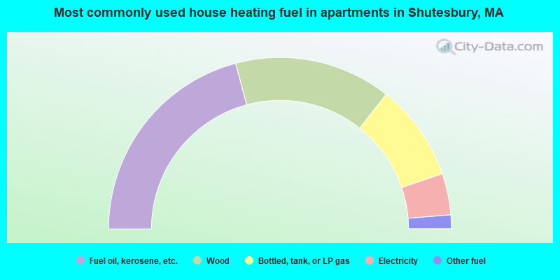
- 41.7%Fuel oil, kerosene, etc.
- 29.6%Wood
- 18.3%Bottled, tank, or LP gas
- 7.8%Electricity
- 2.6%Other fuel
Shutesbury compared to Massachusetts state average:
- Unemployed percentage significantly below state average.
- Black race population percentage significantly below state average.
- Hispanic race population percentage significantly below state average.
- Median age above state average.
- Foreign-born population percentage significantly below state average.
- Renting percentage significantly below state average.
- Length of stay since moving in significantly above state average.
- Number of rooms per house significantly below state average.
- House age significantly below state average.
- Percentage of population with a bachelor's degree or higher above state average.

|
|
Total of 22 patent applications in 2008-2024.