Smyrna, Maine
Submit your own pictures of this town and show them to the world
- OSM Map
- Google Map
- MSN Map
Population change since 2000: +6.5%
 |
| Males: 218 | |
| Females: 224 |
| Median resident age: | 36.8 years |
| Maine median age: | 43.0 years |
Zip codes: 04763.
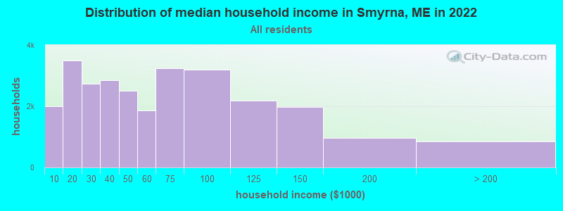
| Smyrna: | $45,670 |
| ME: | $69,543 |
Estimated per capita income in 2022: $24,252 (it was $11,751 in 2000)
Smyrna town income, earnings, and wages data
Estimated median house or condo value in 2022: $129,778 (it was $53,600 in 2000)
| Smyrna: | $129,778 |
| ME: | $290,600 |
Mean prices in 2022: all housing units: $179,108; detached houses: $185,023; townhouses or other attached units: $218,327; in 2-unit structures: $262,505; in 3-to-4-unit structures: $121,406; in 5-or-more-unit structures: $185,084; mobile homes: $117,009; occupied boats, rvs, vans, etc.: $12,682
Detailed information about poverty and poor residents in Smyrna, ME
Compare current foreclosures near Smyrna, ME:
| Photo | Address | Area | Beds / Baths | Price | Details |
|---|---|---|---|---|---|

|
#1
Pleasant St
Houlton, ME 04730
|
1,977 sq. feet
|
1 baths 4 beds |
show details | |

|
#2
Watson Ave
Houlton, ME 04730
|
1 sq. feet
|
1 baths 3 beds |
show details | |

|
#3
Pine Grove Ter
Oakfield, ME 04763
|
- sq. feet
|
- baths - beds |
show details | |

|
#4
High St # 2
Houlton, ME 04730
|
- sq. feet
|
- baths - beds |
show details | |

|
Check over 1 million property listings on Foreclosure.com!
|
browse all offers | |||

- 43398.0%White alone
- 51.1%American Indian alone
- 20.5%Two or more races
- 10.2%Asian alone
- 10.2%Hispanic
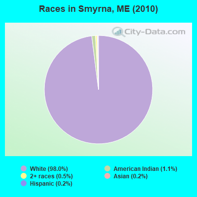
Races in Smyrna detailed stats: ancestries, foreign born residents, place of birth
 Recent articles from our blog. Our writers, many of them Ph.D. graduates or candidates, create easy-to-read articles on a wide variety of topics.

Ancestries: English (27.7%), French (21.9%), Irish (20.2%), United States (14.2%), German (9.6%), Scotch-Irish (5.3%).
Current Local Time: EST time zone
Incorporated on 03/07/1839
Land area: 35.2 square miles.
Population density: 13 people per square mile (very low).
9 residents are foreign born (2.2% North America).
| This town: | 2.2% |
| Maine: | 2.9% |
| Smyrna town: | 1.2% ($659) |
| Maine: | 1.5% ($1,417) |
Nearest city with pop. 50,000+: Portland, ME  (201.3 miles , pop. 64,249).
Nearest city with pop. 200,000+: Boston, MA (302.6 miles , pop. 589,141).
Nearest city with pop. 1,000,000+: Bronx, NY (466.5 miles , pop. 1,332,650).
Nearest cities:
), ), ), Latitude: 46.14 N, Longitude: 68.10 W
Area code commonly used in this area: 207
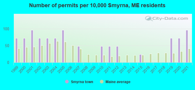
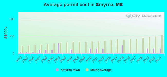
Single-family new house construction building permits:
- 2021: 4 buildings, average cost: $75,000
- 2020: 3 buildings, average cost: $75,000
- 2019: 3 buildings, average cost: $75,000
- 2015: 1 building, cost: $120,000
- 2012: 2 buildings, average cost: $75,000
- 2011: 2 buildings, average cost: $75,000
- 2010: 2 buildings, average cost: $75,000
- 2007: 2 buildings, average cost: $60,000
- 2005: 4 buildings, average cost: $150,200
- 2004: 3 buildings, average cost: $55,000
- 2003: 3 buildings, average cost: $55,000
- 2002: 3 buildings, average cost: $55,000
- 2001: 4 buildings, average cost: $16,700
- 2000: 3 buildings, average cost: $16,700
- 1999: 3 buildings, average cost: $16,700
| Here: | 2.5% |
| Maine: | 3.4% |

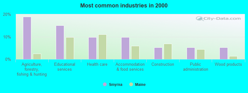
- Agriculture, forestry, fishing & hunting (19.0%)
- Educational services (15.0%)
- Health care (9.8%)
- Accommodation & food services (9.8%)
- Construction (5.2%)
- Public administration (5.2%)
- Wood products (5.2%)
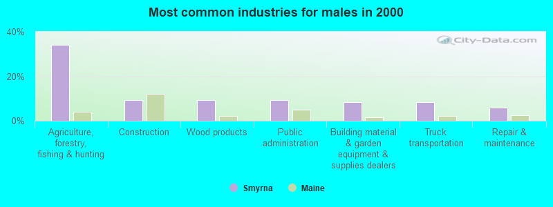
- Agriculture, forestry, fishing & hunting (34.1%)
- Construction (9.4%)
- Wood products (9.4%)
- Public administration (9.4%)
- Building material & garden equipment & supplies dealers (8.2%)
- Truck transportation (8.2%)
- Repair & maintenance (5.9%)

- Educational services (33.8%)
- Health care (22.1%)
- Accommodation & food services (17.6%)
- Finance & insurance (8.8%)
- Department & other general merchandise stores (5.9%)
- Social assistance (4.4%)
- Religious, grantmaking, civic, professional, similar organizations (4.4%)

- Preschool, kindergarten, elementary, and middle school teachers (9.8%)
- Nursing, psychiatric, and home health aides (6.5%)
- Driver/sales workers and truck drivers (6.5%)
- Fishing, hunting, and forestry occupations (5.9%)
- Farmers and farm managers (5.9%)
- Vehicle and mobile equipment mechanics, installers, and repairers (5.2%)
- Other management occupations, except farmers and farm managers (4.6%)

- Driver/sales workers and truck drivers (11.8%)
- Farmers and farm managers (10.6%)
- Fishing, hunting, and forestry occupations (10.6%)
- Vehicle and mobile equipment mechanics, installers, and repairers (9.4%)
- Other management occupations, except farmers and farm managers (5.9%)
- Agricultural workers, including supervisors (5.9%)
- Fire fighting and prevention workers, including supervisors (4.7%)

- Preschool, kindergarten, elementary, and middle school teachers (22.1%)
- Nursing, psychiatric, and home health aides (14.7%)
- Waiters and waitresses (7.4%)
- Cooks and food preparation workers (7.4%)
- Other teachers, instructors, education, training, and library occupations (5.9%)
- Other financial specialists (4.4%)
- Counselors, social workers, and other community and social service specialists (4.4%)
Average climate in Smyrna, Maine
Based on data reported by over 4,000 weather stations


(lower is better)
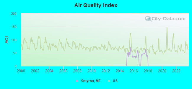
Air Quality Index (AQI) level in 2017 was 46.0. This is significantly better than average.
| City: | 46.0 |
| U.S.: | 72.6 |
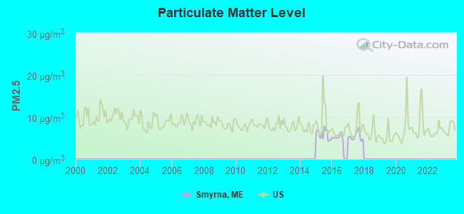
Particulate Matter (PM2.5) [µg/m3] level in 2017 was 5.39. This is significantly better than average. There were 0 monitors within city limits.
| City: | 5.39 |
| U.S.: | 8.11 |
Earthquake activity:
Smyrna-area historical earthquake activity is above Maine state average. It is 85% smaller than the overall U.S. average.On 4/20/2002 at 10:50:47, a magnitude 5.3 (5.3 ML, Depth: 3.0 mi, Class: Moderate, Intensity: VI - VII) earthquake occurred 294.5 miles away from Smyrna center
On 4/20/2002 at 10:50:47, a magnitude 5.2 (5.2 MB, 4.2 MS, 5.2 MW, 5.0 MW) earthquake occurred 296.1 miles away from Smyrna center
On 10/16/2012 at 23:12:25, a magnitude 4.7 (4.7 ML, Depth: 10.0 mi, Class: Light, Intensity: IV - V) earthquake occurred 215.8 miles away from Smyrna center
On 7/14/2006 at 09:34:48, a magnitude 3.9 (3.9 MD, Depth: 8.6 mi, Class: Light, Intensity: II - III) earthquake occurred 58.4 miles away from the city center
On 10/7/1983 at 10:18:46, a magnitude 5.3 (5.1 MB, 5.3 LG, 5.1 ML) earthquake occurred 340.3 miles away from Smyrna center
On 1/19/1982 at 00:14:42, a magnitude 4.7 (4.5 MB, 4.7 MD, 4.5 LG) earthquake occurred 250.5 miles away from Smyrna center
Magnitude types: regional Lg-wave magnitude (LG), body-wave magnitude (MB), duration magnitude (MD), local magnitude (ML), surface-wave magnitude (MS), moment magnitude (MW)
Natural disasters:
The number of natural disasters in Aroostook County (22) is greater than the US average (15).Major Disasters (Presidential) Declared: 13
Emergencies Declared: 9
Causes of natural disasters: Floods: 10, Storms: 8, Snows: 7, Heavy Rains: 2, Blizzard: 1, Hurricane: 1, Ice Storm: 1, Snowfall: 1, Snowstorm: 1, Wind: 1, Winter Storm: 1, Other: 2 (Note: some incidents may be assigned to more than one category).
Hospitals and medical centers near Smyrna:
- HOULTON REGIONAL HOSPITAL Critical Access Hospitals (about 13 miles away; HOULTON, ME)
- THE HOULTON REG PROG CARE FAC (Nursing Home, about 13 miles away; HOULTON, ME)
- FOREST SPRINGS (Hospital, about 13 miles away; HOULTON, ME)
- HARMONY (Hospital, about 13 miles away; HOULTON, ME)
- MADIGAN HOME HEALTH CARE, INC. (Home Health Center, about 13 miles away; HOULTON, ME)
- MADIGAN ESTATES (Nursing Home, about 13 miles away; HOULTON, ME)
Colleges/universities with over 2000 students nearest to Smyrna:
- University of Maine (about 91 miles; Orono, ME; Full-time enrollment: 8,931)
- Husson University (about 97 miles; Bangor, ME; FT enrollment: 2,421)
- University of Maine at Farmington (about 143 miles; Farmington, ME; FT enrollment: 2,036)
- University of Maine at Augusta (about 150 miles; Augusta, ME; FT enrollment: 3,204)
- Saint Joseph's College of Maine (about 198 miles; Standish, ME; FT enrollment: 2,010)
- Southern Maine Community College (about 202 miles; South Portland, ME; FT enrollment: 4,666)
- University of Southern Maine (about 202 miles; Portland, ME; FT enrollment: 6,647)
Points of interest:
Notable location: Emerson Siding (A). Display/hide its location on the map
Church in Smyrna: Smyrna Mills United Methodist Church (A). Display/hide its location on the map
Cemeteries: Yerxa Cemetery (1), Amish Cemetery (2), Smyrna Mills Cemetery (3), Stewart Cemetery (4). Display/hide their locations on the map
Lakes and swamps: White Lake (A), Duck Pond (B), Half Moon Pond (C), Innes Beaver Pond (D). Display/hide their locations on the map
Streams, rivers, and creeks: Soule Brook (A), Little Mill Brook (B), Marley Brook (C), Dunn Brook (D), Dudley Brook (E), Duck Pond Outlet (F), Moose Brook (G), Limestone Brook (H). Display/hide their locations on the map
Drinking water stations with addresses in Smyrna and their reported violations in the past:
BROOKSIDE INN (Population served: 176, Groundwater):Past monitoring violations:
- 3 routine major monitoring violations
- 2 regular monitoring violations
| This town: | 2.9 people |
| Maine: | 2.3 people |
| This town: | 69.7% |
| Whole state: | 62.9% |
| This town: | 9.0% |
| Whole state: | 9.4% |
Likely homosexual households (counted as self-reported same-sex unmarried-partner households)
- Lesbian couples: 0.6% of all households
- Gay men: 0.6% of all households
| This town: | 20.3% |
| Whole state: | 10.9% |
| This town: | 9.0% |
| Whole state: | 4.1% |
For population 15 years and over in Smyrna:
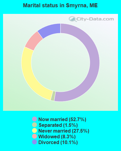
- Never married: 27.5%
- Now married: 52.7%
- Separated: 1.5%
- Widowed: 8.3%
- Divorced: 10.1%
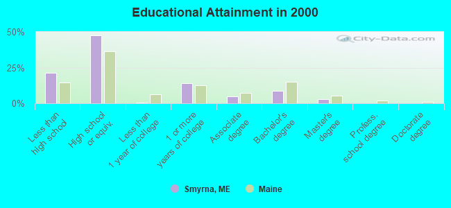
For population 25 years and over in Smyrna:
- High school or higher: 78.5%
- Bachelor's degree or higher: 11.7%
- Graduate or professional degree: 3.0%
- Unemployed: 11.0%
- Mean travel time to work (commute): 24.7 minutes
| Here: | 10.4 |
| Maine average: | 11.2 |


Graphs represent county-level data. Detailed 2008 Election Results
Religion statistics for Smyrna, ME (based on Aroostook County data)


| Religion | Adherents | Congregations |
|---|---|---|
| Catholic | 22,200 | 27 |
| Mainline Protestant | 5,845 | 40 |
| Evangelical Protestant | 4,411 | 51 |
| Other | 957 | 7 |
| Orthodox | 10 | 1 |
| None | 38,447 | - |
Food Environment Statistics:
| Here: | 4.03 / 10,000 pop. |
| Maine: | 2.80 / 10,000 pop. |
| Aroostook County: | 0.14 / 10,000 pop. |
| Maine: | 0.14 / 10,000 pop. |
| Here: | 2.22 / 10,000 pop. |
| State: | 2.20 / 10,000 pop. |
| Here: | 7.78 / 10,000 pop. |
| Maine: | 5.75 / 10,000 pop. |
| This county: | 9.17 / 10,000 pop. |
| State: | 11.02 / 10,000 pop. |
| Aroostook County: | 11.7% |
| Maine: | 8.2% |
| Aroostook County: | 27.6% |
| Maine: | 25.0% |
Strongest AM radio stations in Smyrna:
- WREM (710 AM; daytime; 5 kW; MONTICELLO, ME; Owner: ALLAN H WEINER)
- WFST (600 AM; 5 kW; CARIBOU, ME; Owner: NORTHERN BROADCAST MINISTRIES, INC.)
- WEGP (1390 AM; 5 kW; PRESQUE ISLE, ME; Owner: DECELLES/SMITH MEDIA, INC.)
- WZON (620 AM; 5 kW; BANGOR, ME; Owner: THE ZONE CORPORATION)
- WRKO (680 AM; 50 kW; BOSTON, MA; Owner: ENTERCOM BOSTON LICENSE, LLC)
- WCHP (760 AM; 35 kW; CHAMPLAIN, NY; Owner: CHAMPLAIN RADIO, INC.)
- WEEI (850 AM; 50 kW; BOSTON, MA; Owner: ENTERCOM BOSTON LICENSE, LLC)
- WNNZ (640 AM; 50 kW; WESTFIELD, MA; Owner: CLEAR CHANNEL BROADCASTING LICENSES, INC.)
- WSKW (1160 AM; 10 kW; SKOWHEGAN, ME; Owner: MOUNTAIN WIRELESS, INCORPORATED)
- WABI (910 AM; 5 kW; BANGOR, ME; Owner: CLEAR CHANNEL BROADCASTING LICENSES, INC.)
- WCRN (830 AM; 50 kW; WORCESTER, MA; Owner: CARTER BROADCASTING CORPORATION)
- WBZ (1030 AM; 50 kW; BOSTON, MA; Owner: INFINITY BROADCASTING OPERATIONS, INC.)
- WTME (780 AM; 10 kW; RUMFORD, ME; Owner: MOUNTAIN VALLEY BROADCASTING, INC.)
Strongest FM radio stations in Smyrna:
- WHOU-FM (100.1 FM; HOULTON, ME; Owner: COUNTY COMMUNICATIONS, INC.)
- WQHR (96.1 FM; PRESQUE ISLE, ME; Owner: CITADEL BROADCASTING COMPANY)
- WOZI (101.9 FM; PRESQUE ISLE, ME; Owner: CITADEL BROADCASTING COMPANY)
- WMEM (106.1 FM; PRESQUE ISLE, ME; Owner: MAINE PUBLIC BROADCASTING CORPORATION)
- WBPW (96.9 FM; PRESQUE ISLE, ME; Owner: CITADEL BROADCASTING COMPANY)
- W274AF (102.7 FM; PRESQUE ISLE, ME; Owner: BANGOR BAPTIST CHURCH)
- National Bridge Inventory (NBI) Statistics
- 7Number of bridges
- 89ft / 27.4mTotal length
- 13,644Total average daily traffic
- 680Total average daily truck traffic
- 19,281Total future (year 2036) average daily traffic
FCC Registered Antenna Towers:
4- Alyse Brussard, 62 Cadbury Lane (Atc 204554) (Lat: 46.143083 Lon: -68.111778), Type: 106.7, Structure height: 23003 m, Overall height: 106.7 m, Registrant: American Towers LLC, Faa-Fcc@americantower.Com, , Wobur-n, Phone: (781) 926-4500
- Alyse Brussard, 62 Cadbury Lane (Atc 204554) (Lat: 46.143083 Lon: -68.111778), Type: 106.7, Structure height: 23003 m, Overall height: 106.7 m, Registrant: American Towers LLC, Faa-Fcc@americantower.Com, , Wobur-n, Phone: (781) 926-4500
- Bridget Carter, 62 Cadbury Lane (Atc 204554) (Lat: 46.143083 Lon: -68.111778), Type: 106.7, Structure height: 23003 m, Overall height: 105.2 m, Registrant: American Towers LLC, Faa-Fcc@americantower.Com, , Wobur-n, Phone: (781) 926-4500
- Bridget Carter, 62 Cadbury Lane (Atc 204554) (Lat: 46.143083 Lon: -68.111778), Type: 106.7, Structure height: 23003 m, Overall height: 105.2 m, Registrant: American Towers LLC, Faa-Fcc@americantower.Com, , Wobur-n, Phone: (781) 926-4500
FCC Registered Broadcast Land Mobile Towers:
2- Smyrna Center (Lat: 46.162000 Lon: -68.096417), Call Sign: WGT437,
Assigned Frequencies: 452.875 MHz, Grant Date: 03/30/2005, Expiration Date: 06/26/2015, Cancellation Date: 05/11/2011, Registrant: Aroostook County Emergency Management Agency, 158 Sweden Street, Caribou, ME 04736, Phone: (207) 493-4328, Fax: (207) 493-4357, Email:
- Smyrna Center (Lat: 46.162000 Lon: -68.096417), Call Sign: KNDK998, Licensee ID: L00099376,
Assigned Frequencies: 463.850 MHz, Grant Date: 05/17/2022, Expiration Date: 08/12/2032, Certifier: Gerard E Ouellette, Registrant: Atlantic Communications, Inc.
FCC Registered Microwave Towers:
1- Smyrna, 62 Cadbury Ave (Lat: 46.143083 Lon: -68.111778), Type: Ltower, Structure height: 105.2 m, Overall height: 106.4 m, Call Sign: WQUS302,
Assigned Frequencies: 11265.0 MHz, 11265.0 MHz, 11265.0 MHz, 11265.0 MHz, 11265.0 MHz, 11265.0 MHz, 11265.0 MHz, 11265.0 MHz, 11265.0 MHz, 11385.0 MHz... (+8 more), Grant Date: 09/25/2014, Expiration Date: 09/25/2024, Cancellation Date: 10/22/2020, Certifier: Jessica B Lyons, Registrant: At&t Services, Inc., 208 S. Akard Street, Room 2100, Dallas, TX 75202, Phone: (855) 699-7073, Email:
FCC Registered Paging Towers:
1- 4 Miles Ne Of Smyrna Mills (Lat: 46.161972 Lon: -68.096389), Call Sign: KKB660,
Assigned Frequencies: 158.700 MHz, Grant Date: 04/23/2019, Expiration Date: 04/01/2029, Registrant: Wilkinson Barker Knauer, LLP, 1800 M Street, N.W., Suite 800n, Washington, DC 20036, Phone: (202) 783-4141, Fax: (202) 783-5851, Email:
FCC Registered Amateur Radio Licenses:
2- Call Sign: KB1LOG, Licensee ID: L00906737, Grant Date: 08/17/2004, Expiration Date: 08/17/2014, Cancellation Date: 05/19/2006, Certifier: Herb F Boutilier, Registrant: Herb F Boutilier, Smyrna, ME 04780
- Call Sign: K1LOG, Previous Call Sign: KB1LOG, Licensee ID: L00906737, Grant Date: 05/03/2016, Expiration Date: 05/19/2026, Certifier: Herb F Boutilier, Registrant: Herb F Boutilier, Smyrna, ME 04780
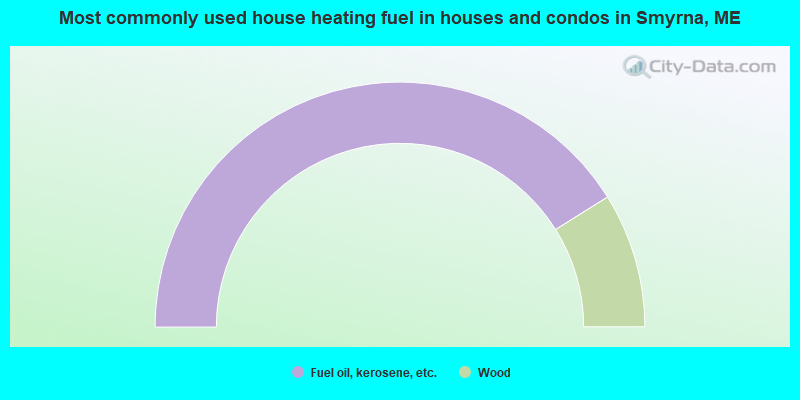
- 82.2%Fuel oil, kerosene, etc.
- 17.8%Wood
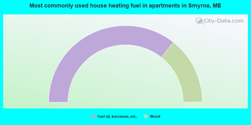
- 71.4%Fuel oil, kerosene, etc.
- 28.6%Wood
Smyrna compared to Maine state average:
- Median household income below state average.
- Median house value below state average.
- Black race population percentage significantly below state average.
- Hispanic race population percentage significantly below state average.
- Median age below state average.
- Foreign-born population percentage below state average.
- Renting percentage below state average.
- Length of stay since moving in significantly above state average.
- Number of rooms per house significantly below state average.
- House age significantly below state average.
- Percentage of population with a bachelor's degree or higher significantly below state average.