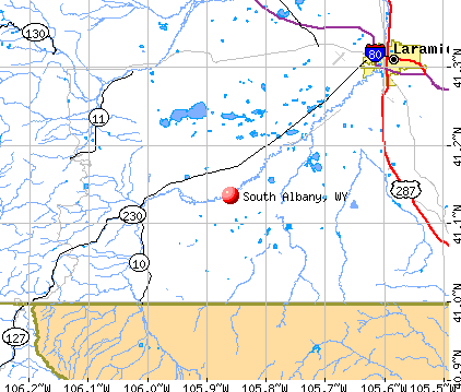
South Albany, Wyoming
Submit your own pictures of this place and show them to the world
- OSM Map
- General Map
- Google Map
- MSN Map
| Males: 650 | |
| Females: 610 |
| Median resident age: | 46.6 years |
| Wyoming median age: | 36.2 years |
Zip code: 82070
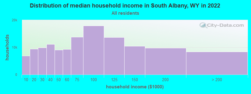
| South Albany: | $76,026 |
| WY: | $70,042 |
Estimated per capita income in 2022: $52,933 (it was $26,239 in 2000)
South Albany CCD income, earnings, and wages data
Estimated median house or condo value in 2022: $473,114 (it was $167,100 in 2000)
| South Albany: | $473,114 |
| WY: | $292,300 |
Mean prices in 2022: all housing units: $352,624; detached houses: $410,057; townhouses or other attached units: $256,671; in 2-unit structures: $322,055; in 3-to-4-unit structures: $409,873; mobile homes: $42,771
Detailed information about poverty and poor residents in South Albany, WY


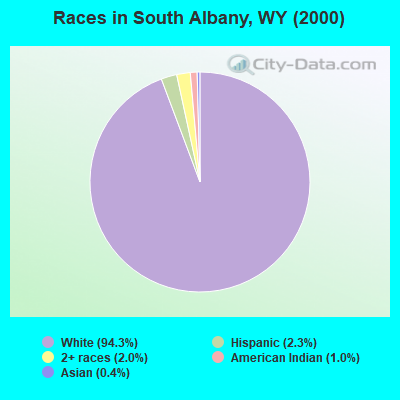
- 1,16894.3%White alone
- 282.3%Hispanic
- 252.0%Two or more races
- 121.0%American Indian alone
- 50.4%Asian alone
- 10.08%Black alone
Races in South Albany detailed stats: ancestries, foreign born residents, place of birth
 Recent articles from our blog. Our writers, many of them Ph.D. graduates or candidates, create easy-to-read articles on a wide variety of topics.

Current Local Time: MST time zone
Land area: 1175.3 square miles.
Population density: 1.1 people per square mile (very low).

| South Albany CCD: | 0.4% ($691) |
| Wyoming: | 0.7% ($627) |
Nearest city with pop. 50,000+: Cheyenne, WY  (55.1 miles , pop. 53,011).
Nearest city with pop. 200,000+: West Adams, CO (98.4 miles , pop. 259,628).
Nearest city with pop. 1,000,000+: Phoenix, AZ (627.1 miles , pop. 1,321,045).
Nearest cities:
Latitude: 41.14 N, Longitude: 105.86 W

| Here: | 2.1% |
| Wyoming: | 2.5% |
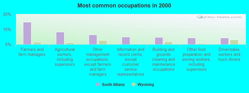
- Farmers and farm managers (14.9%)
- Agricultural workers, including supervisors (8.2%)
- Other management occupations, except farmers and farm managers (6.4%)
- Information and record clerks, except customer service representatives (5.0%)
- Building and grounds cleaning and maintenance occupations (4.7%)
- Other food preparation and serving workers, including supervisors (4.3%)
- Driver/sales workers and truck drivers (4.3%)
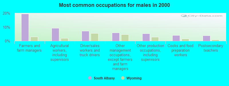
- Farmers and farm managers (19.7%)
- Agricultural workers, including supervisors (9.3%)
- Driver/sales workers and truck drivers (7.3%)
- Other management occupations, except farmers and farm managers (6.0%)
- Other production occupations, including supervisors (5.4%)
- Cooks and food preparation workers (4.1%)
- Postsecondary teachers (3.9%)
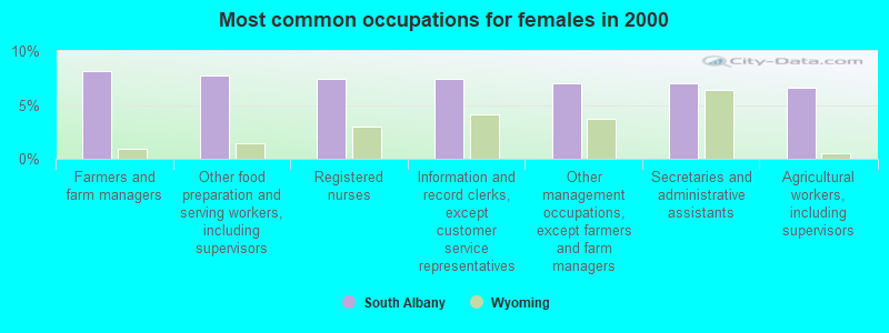
- Farmers and farm managers (8.1%)
- Other food preparation and serving workers, including supervisors (7.7%)
- Registered nurses (7.4%)
- Information and record clerks, except customer service representatives (7.4%)
- Other management occupations, except farmers and farm managers (7.0%)
- Secretaries and administrative assistants (7.0%)
- Agricultural workers, including supervisors (6.6%)
Average climate in South Albany, Wyoming
Based on data reported by over 4,000 weather stations


(lower is better)
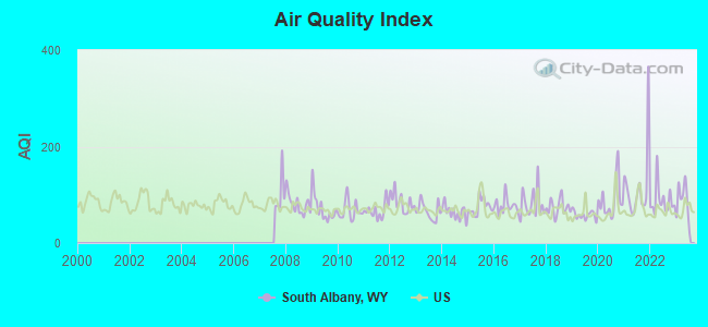
Air Quality Index (AQI) level in 2023 was 87.6. This is worse than average.
| City: | 87.6 |
| U.S.: | 72.6 |
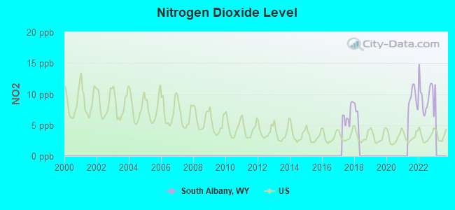
Nitrogen Dioxide (NO2) [ppb] level in 2022 was 9.54. This is significantly worse than average. Closest monitor was 18.2 miles away from the city center.
| City: | 9.54 |
| U.S.: | 5.11 |
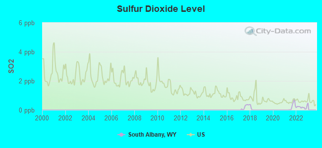
Sulfur Dioxide (SO2) [ppb] level in 2022 was 0.184. This is significantly better than average. Closest monitor was 18.2 miles away from the city center.
| City: | 0.184 |
| U.S.: | 1.515 |
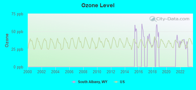
Ozone [ppb] level in 2022 was 34.1. This is about average. Closest monitor was 18.2 miles away from the city center.
| City: | 34.1 |
| U.S.: | 33.3 |
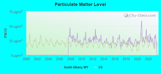
Particulate Matter (PM10) [µg/m3] level in 2022 was 25.2. This is worse than average. Closest monitor was 16.5 miles away from the city center.
| City: | 25.2 |
| U.S.: | 19.2 |
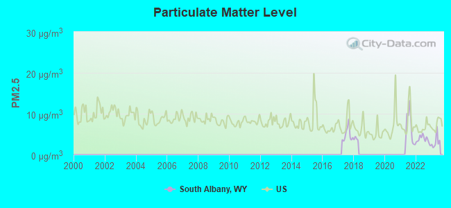
Particulate Matter (PM2.5) [µg/m3] level in 2023 was 3.16. This is significantly better than average. Closest monitor was 18.2 miles away from the city center.
| City: | 3.16 |
| U.S.: | 8.11 |
Tornado activity:
South Albany-area historical tornado activity is above Wyoming state average. It is 70% smaller than the overall U.S. average.
On 4/23/1960, a category F3 (max. wind speeds 158-206 mph) tornado 34.2 miles away from the South Albany place center injured one person and caused between $5000 and $50,000 in damages.
On 5/22/2008, a category F2 (max. wind speeds 113-157 mph) tornado 28.0 miles away from the place center injured one person.
Earthquake activity:
South Albany-area historical earthquake activity is significantly above Wyoming state average. It is 736% greater than the overall U.S. average.On 8/18/1959 at 06:37:13, a magnitude 7.7 (7.7 UK, Class: Major, Intensity: VIII - XII) earthquake occurred 339.6 miles away from the city center, causing $26,000,000 total damage
On 10/18/1984 at 15:30:23, a magnitude 5.5 (5.4 MB, 5.1 MS, 5.5 ML, Class: Moderate, Intensity: VI - VII) earthquake occurred 88.4 miles away from the city center
On 10/28/1983 at 14:06:06, a magnitude 7.3 (6.2 MB, 7.3 MS, 7.0 MW) earthquake occurred 452.3 miles away from the city center, causing 2 deaths (2 shaking deaths) and 3 injuries, causing $15,000,000 total damage
On 3/28/1975 at 02:31:05, a magnitude 6.2 (6.1 MB, 6.0 MS, 6.2 ML, Class: Strong, Intensity: VII - IX) earthquake occurred 347.5 miles away from South Albany center
On 2/3/1994 at 09:05:04, a magnitude 5.8 (5.4 MB, 5.5 MS, 5.8 MW, 5.8 ML, Depth: 4.9 mi) earthquake occurred 286.0 miles away from South Albany center
On 6/30/1975 at 18:54:13, a magnitude 6.1 (5.6 MB, 5.9 MS, 6.1 UK, 6.1 ML) earthquake occurred 347.6 miles away from South Albany center
Magnitude types: body-wave magnitude (MB), local magnitude (ML), surface-wave magnitude (MS), moment magnitude (MW)
Natural disasters:
The number of natural disasters in Albany County (7) is smaller than the US average (15).Major Disasters (Presidential) Declared: 2
Causes of natural disasters: Fires: 4, Floods: 2, Storms: 2, Landslide: 1, Other: 1 (Note: some incidents may be assigned to more than one category).
Colleges/universities with over 2000 students nearest to South Albany:
- University of Wyoming (about 20 miles; Laramie, WY; Full-time enrollment: 10,810)
- Wyotech-Laramie (about 20 miles; Laramie, WY; FT enrollment: 2,765)
- Laramie County Community College (about 57 miles; Cheyenne, WY; FT enrollment: 3,288)
- Colorado State University-Fort Collins (about 57 miles; Fort Collins, CO; FT enrollment: 25,099)
- Aims Community College (about 77 miles; Greeley, CO; FT enrollment: 3,598)
- University of Northern Colorado (about 80 miles; Greeley, CO; FT enrollment: 11,469)
- University of Colorado Boulder (about 85 miles; Boulder, CO; FT enrollment: 28,328)
Points of interest:
Notable locations in South Albany: Leroy Bridge (A), Lewis Lake Campground (B), Libby Creek Picnic Ground (C), Loban Ranch (D), Markley Ranch (E), May Ranch (F), McCue Ranch (G), McGill Ranch (H), Medicine Bow Ski Area (I), Miller Ranch (J), Dry Park (K), Nash Fork Picnic Ground (L), Boswell Ranch (M), Nelson Park (N), Douglas Creek Campground (O), North Fork Campground (P), Olson Ranch (Q), Riverside Ranch (R), Robertson Ranch (S), Russell Ranch (T). Display/hide their locations on the map
Church in South Albany: Open Air Chapel (A). Display/hide its location on the map
Lakes and reservoirs: Hanging Lake (A), Crescent Lake (B), Glacier Lakes (C), Towner Lake (D), Hardigan Lake (E), Soda Lake (F), Mortenson Lake (G), Pilger Lake (H). Display/hide their locations on the map
Streams, rivers, and creeks: Boswell Creek (A), Running Water Creek (B), Lone Tree Creek (C), Shell Creek (D), Bull Run Creek (E), Stink Creek (F), Antelope Creek (G), Hecht Creek (H), Little Fish Creek (I). Display/hide their locations on the map
Parks in South Albany include: Pelton Park (1), Hutton Lake National Wildlife Refuge (2). Display/hide their locations on the map
| This place: | 2.2 people |
| Wyoming: | 2.4 people |
| This place: | 66.8% |
| Whole state: | 64.6% |
| This place: | 7.2% |
| Whole state: | 7.1% |
Likely homosexual households (counted as self-reported same-sex unmarried-partner households)
- Lesbian couples: 0.4% of all households
- Gay men: 0.3% of all households
| This place: | 9.9% |
| Whole state: | 11.4% |
| This place: | 4.7% |
| Whole state: | 4.5% |
For population 15 years and over in South Albany:
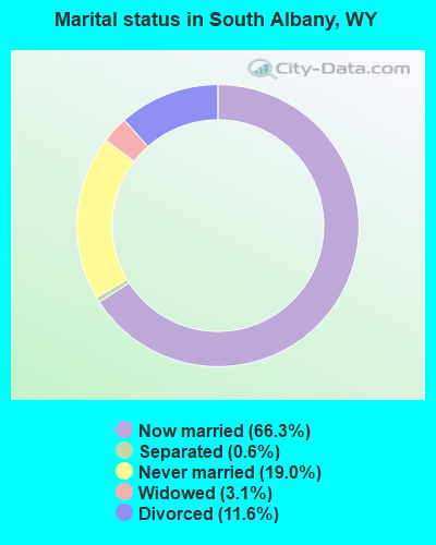
- Never married: 19.0%
- Now married: 66.3%
- Separated: 0.6%
- Widowed: 3.1%
- Divorced: 11.6%
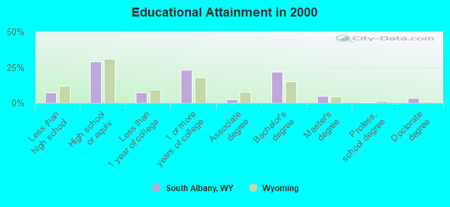
For population 25 years and over in South Albany:
- High school or higher: 92.7%
- Bachelor's degree or higher: 30.4%
- Graduate or professional degree: 8.6%
- Unemployed: 4.6%
- Mean travel time to work (commute): 31.6 minutes
| Here: | 9.5 |
| Wyoming average: | 10.0 |
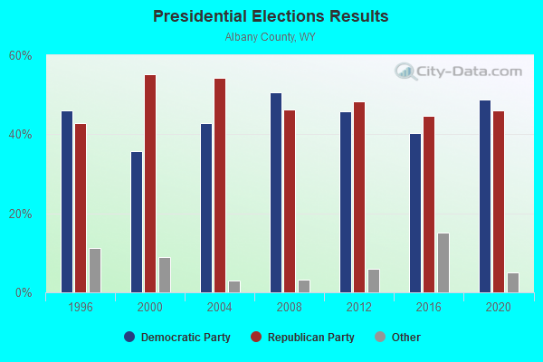
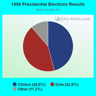
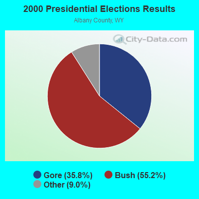
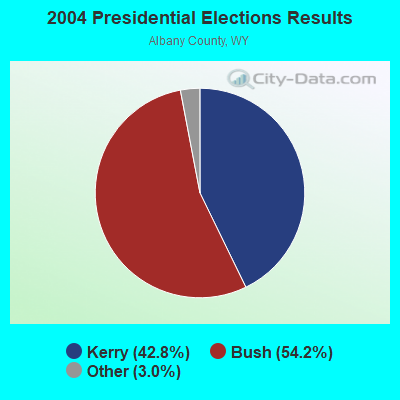
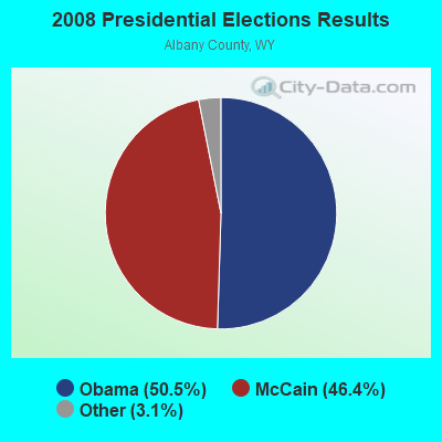
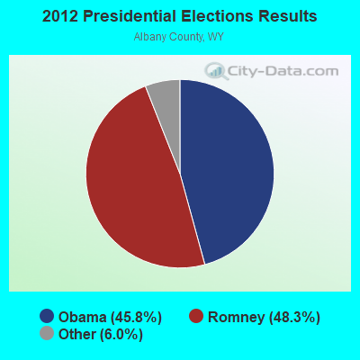
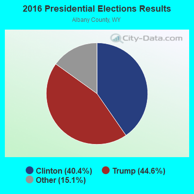
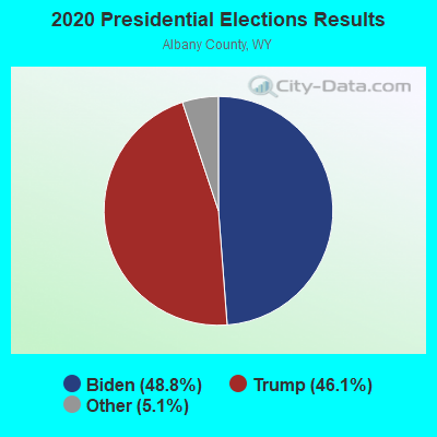
Graphs represent county-level data. Detailed 2008 Election Results
Religion statistics for South Albany, WY (based on Albany County data)
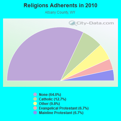
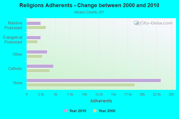
| Religion | Adherents | Congregations |
|---|---|---|
| Catholic | 4,627 | 2 |
| Other | 3,570 | 16 |
| Evangelical Protestant | 2,441 | 26 |
| Mainline Protestant | 2,434 | 9 |
| None | 23,227 | - |
Food Environment Statistics:
| This county: | 0.62 / 10,000 pop. |
| Wyoming: | 2.10 / 10,000 pop. |
| This county: | 0.31 / 10,000 pop. |
| Wyoming: | 0.27 / 10,000 pop. |
| Albany County: | 0.93 / 10,000 pop. |
| Wyoming: | 0.65 / 10,000 pop. |
| Albany County: | 2.79 / 10,000 pop. |
| Wyoming: | 5.36 / 10,000 pop. |
| This county: | 9.60 / 10,000 pop. |
| Wyoming: | 10.08 / 10,000 pop. |
| Albany County: | 4.5% |
| State: | 7.1% |
| Albany County: | 18.6% |
| Wyoming: | 24.4% |
Strongest AM radio stations in South Albany:
- KKHI (1210 AM; 10 kW; LARAMIE, WY; Owner: LARAMIE MOUNTAIN BROADCASTING, L.L.C.)
- KOWB (1290 AM; 5 kW; LARAMIE, WY; Owner: CLEAR CHANNEL BROADCASTING LICENSES, INC.)
- KKZN (760 AM; 50 kW; THORNTON, CO; Owner: JACOR BROADCASTING OF COLORADO, INC.)
- KLTT (670 AM; 50 kW; COMMERCE CITY, CO; Owner: KLZ RADIO, INC.)
- KLMO (1060 AM; 30 kW; LONGMONT, CO; Owner: PILGRIM COMMUNICATIONS, INC.)
- KGAB (650 AM; 8 kW; ORCHARD VALLEY, WY; Owner: CITICASTERS LICENSES, L.P.)
- KOA (850 AM; 50 kW; DENVER, CO; Owner: JACOR BROADCASTING OF COLORADO, INC.)
- KTWO (1030 AM; 50 kW; CASPER, WY; Owner: CITICASTERS LICENSES, L.P.)
- KMXA (1090 AM; 50 kW; AURORA, CO; Owner: ENTRAVISION HOLDINGS, LLC)
- KIMB (1260 AM; 50 kW; KIMBALL, NE; Owner: G & L INVESTMENTS, LLC)
- KCOL (600 AM; 5 kW; WELLINGTON, CO; Owner: JACOR BROADCASTING OF COLORADO, INC.)
- KJJL (1370 AM; 10 kW; CHEYENNE, WY; Owner: CHRISTUS BROADCASTING, INC.)
- KKWY (1630 AM; 10 kW; FOX FARM, WY; Owner: CHRISTUS BROADCASTING, INC.)
Strongest FM radio stations in South Albany:
- KARS-FM (102.9 FM; LARAMIE, WY; Owner: AGM-NEVADA LLC)
- KIMX (105.5 FM; LARAMIE, WY; Owner: LARAMIE MOUNTAIN BROADCASTING, L.L.C.)
- KRQU (104.5 FM; LARAMIE, WY; Owner: LARAMIE MOUNTAIN BROADCASTING, LLC)
- KUWR (91.9 FM; LARAMIE, WY; Owner: UNIVERSITY OF WYOMING)
- K298AE (107.5 FM; LARAMIE, WY; Owner: WESTERN INSPIRATIONAL BROADCASTERS, INC)
- KCGY (95.1 FM; LARAMIE, WY; Owner: CLEAR CHANNEL BROADCASTING LICENSES, INC.)
- KHAT (96.7 FM; LARAMIE, WY; Owner: RULE COMMUNICATIONS)
- K205EL (88.9 FM; LARAMIE, WY; Owner: EDUCATIONAL MEDIA FOUNDATION)
- K296BO (107.1 FM; LARAMIE, WY; Owner: LARAMIE PLAINS ANT. TV ASSOC. INC.)
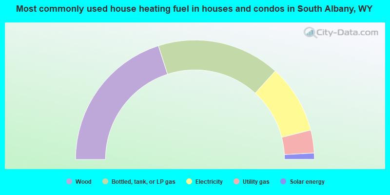
- 40.1%Wood
- 33.4%Bottled, tank, or LP gas
- 18.6%Electricity
- 6.2%Utility gas
- 1.7%Solar energy
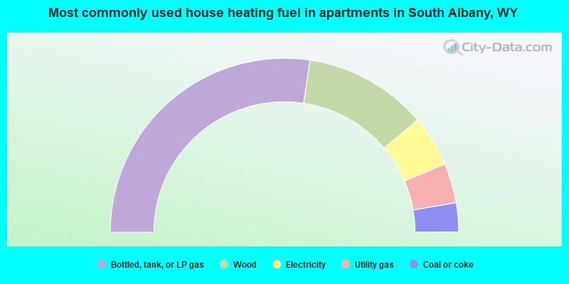
- 54.7%Bottled, tank, or LP gas
- 23.0%Wood
- 9.5%Electricity
- 7.4%Utility gas
- 5.4%Coal or coke
South Albany compared to Wyoming state average:
- Median house value above state average.
- Unemployed percentage significantly below state average.
- Black race population percentage significantly below state average.
- Hispanic race population percentage significantly below state average.
- Median age above state average.
- Foreign-born population percentage significantly below state average.
- Renting percentage below state average.
- Length of stay since moving in significantly above state average.
- Number of rooms per house significantly below state average.
- House age significantly below state average.