South Bannock, Idaho
Submit your own pictures of this place and show them to the world
- OSM Map
- General Map
- Google Map
- MSN Map

| Males: 2,804 | |
| Females: 3,055 |
| Median resident age: | 37.2 years |
| Idaho median age: | 33.2 years |
Zip code: 83214
| South Bannock: | $61,553 |
| ID: | $72,785 |
Estimated per capita income in 2022: $26,137 (it was $14,652 in 2000)
South Bannock CCD income, earnings, and wages data
Estimated median house or condo value in 2022: $317,317 (it was $88,200 in 2000)
| South Bannock: | $317,317 |
| ID: | $432,500 |
Mean prices in 2022: all housing units: $338,815; detached houses: $360,125; townhouses or other attached units: $282,569; in 2-unit structures: $300,564; in 3-to-4-unit structures: $208,638; in 5-or-more-unit structures: $635,187; mobile homes: $60,431; occupied boats, rvs, vans, etc.: $59,400
Detailed information about poverty and poor residents in South Bannock, ID
Compare current foreclosures near South Bannock, ID:
| Photo | Address | Area | Beds / Baths | Price | Details |
|---|---|---|---|---|---|

|
#1
E Bowman Rd
Downey, ID 83234
|
- sq. feet
|
- baths - beds |
show details | |

|
#2
S 4th St E
Downey, ID 83234
|
- sq. feet
|
- baths - beds |
show details | |

|
#3
S Dempsey Creek Rd
Lava Hot Springs, ID 83246
|
- sq. feet
|
- baths - beds |
show details | |

|
#4
S 4th W # 2
Lava Hot Springs, ID 83246
|
- sq. feet
|
- baths - beds |
show details | |

|
#5
W Walker Creek Rd
Mccammon, ID 83250
|
- sq. feet
|
- baths - beds |
show details | |

|
#6
Elm St
Lava Hot Springs, ID 83246
|
- sq. feet
|
- baths - beds |
show details | |

|
Check over 1 million property listings on Foreclosure.com!
|
browse all offers | |||

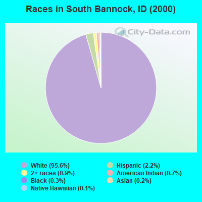
- 5,28695.6%White alone
- 1192.2%Hispanic
- 500.9%Two or more races
- 400.7%American Indian alone
- 140.3%Black alone
- 120.2%Asian alone
- 60.1%Native Hawaiian and Other
Pacific Islander alone - 10.02%Other race alone
Races in South Bannock detailed stats: ancestries, foreign born residents, place of birth
 Recent articles from our blog. Our writers, many of them Ph.D. graduates or candidates, create easy-to-read articles on a wide variety of topics.

Current Local Time: MST time zone
Land area: 764.9 square miles.
Population density: 7.7 people per square mile (very low).

| South Bannock CCD: | 0.9% ($767) |
| Idaho: | 1.0% ($1,007) |
Nearest city with pop. 50,000+: Pocatello, ID  (28.0 miles , pop. 51,466).
Nearest city with pop. 200,000+: Northeast Jefferson, CO (414.2 miles , pop. 450,166).
Nearest city with pop. 1,000,000+: Phoenix, AZ (623.0 miles , pop. 1,321,045).
Nearest cities:
), Latitude: 42.54 N, Longitude: 112.15 W
Area code commonly used in this area: 208

| Here: | 3.0% |
| Idaho: | 3.1% |
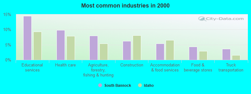
- Educational services (14.5%)
- Health care (9.8%)
- Agriculture, forestry, fishing & hunting (8.0%)
- Construction (6.2%)
- Accommodation & food services (5.3%)
- Food & beverage stores (4.3%)
- Truck transportation (3.6%)
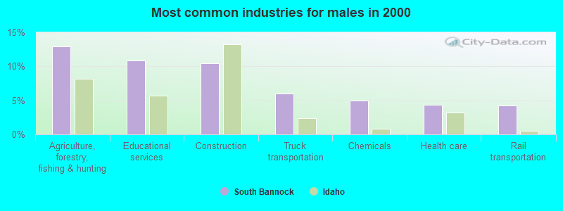
- Agriculture, forestry, fishing & hunting (13.0%)
- Educational services (10.9%)
- Construction (10.5%)
- Truck transportation (6.0%)
- Chemicals (4.9%)
- Health care (4.4%)
- Rail transportation (4.2%)
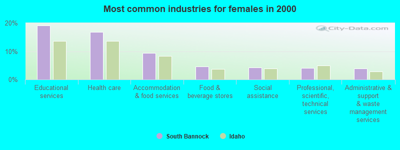
- Educational services (19.1%)
- Health care (16.9%)
- Accommodation & food services (9.5%)
- Food & beverage stores (4.7%)
- Social assistance (4.3%)
- Professional, scientific, technical services (4.1%)
- Administrative & support & waste management services (4.0%)

- Other sales and related occupations, including supervisors (5.0%)
- Building and grounds cleaning and maintenance occupations (5.0%)
- Preschool, kindergarten, elementary, and middle school teachers (4.7%)
- Driver/sales workers and truck drivers (4.3%)
- Farmers and farm managers (4.3%)
- Agricultural workers, including supervisors (3.9%)
- Cashiers (3.5%)

- Driver/sales workers and truck drivers (7.7%)
- Farmers and farm managers (7.3%)
- Other sales and related occupations, including supervisors (5.9%)
- Vehicle and mobile equipment mechanics, installers, and repairers (5.5%)
- Agricultural workers, including supervisors (5.1%)
- Building and grounds cleaning and maintenance occupations (4.5%)
- Electrical equipment mechanics and other installation, maintenance, and repair workers, including supervisors (3.7%)

- Preschool, kindergarten, elementary, and middle school teachers (6.7%)
- Cashiers (5.9%)
- Building and grounds cleaning and maintenance occupations (5.5%)
- Waiters and waitresses (5.5%)
- Information and record clerks, except customer service representatives (4.8%)
- Other healthcare support occupations (4.4%)
- Other teachers, instructors, education, training, and library occupations (3.9%)
Average climate in South Bannock, Idaho
Based on data reported by over 4,000 weather stations


Earthquake activity:
South Bannock-area historical earthquake activity is significantly above Idaho state average. It is 1902% greater than the overall U.S. average.On 8/18/1959 at 06:37:13, a magnitude 7.7 (7.7 UK, Class: Major, Intensity: VIII - XII) earthquake occurred 159.1 miles away from the city center, causing $26,000,000 total damage
On 10/28/1983 at 14:06:06, a magnitude 7.3 (6.2 MB, 7.3 MS, 7.0 MW) earthquake occurred 135.3 miles away from the city center, causing 2 deaths (2 shaking deaths) and 3 injuries, causing $15,000,000 total damage
On 10/3/1915 at 06:52:48, a magnitude 7.6 (7.6 UK) earthquake occurred 310.8 miles away from the city center
On 3/28/1975 at 02:31:05, a magnitude 6.2 (6.1 MB, 6.0 MS, 6.2 ML, Class: Strong, Intensity: VII - IX) earthquake occurred 39.9 miles away from the city center
On 3/31/2020 at 23:52:30, a magnitude 6.5 (6.5 MW, Depth: 7.5 mi) earthquake occurred 200.0 miles away from South Bannock center
On 2/3/1994 at 09:05:04, a magnitude 5.8 (5.4 MB, 5.5 MS, 5.8 MW, 5.8 ML, Depth: 4.9 mi, Class: Moderate, Intensity: VI - VII) earthquake occurred 62.4 miles away from South Bannock center
Magnitude types: body-wave magnitude (MB), local magnitude (ML), surface-wave magnitude (MS), moment magnitude (MW)
Natural disasters:
The number of natural disasters in Bannock County (4) is a lot smaller than the US average (15).Major Disasters (Presidential) Declared: 2
Emergencies Declared: 1
Causes of natural disasters: Fire: 1, Flood: 1, Heavy Rain: 1, Hurricane: 1, Other: 1 (Note: some incidents may be assigned to more than one category).
Colleges/universities with over 2000 students nearest to South Bannock:
- Idaho State University (about 27 miles; Pocatello, ID; Full-time enrollment: 10,350)
- Utah State University (about 58 miles; Logan, UT; FT enrollment: 21,131)
- Brigham Young University-Idaho (about 91 miles; Rexburg, ID; FT enrollment: 30,522)
- Weber State University (about 94 miles; Ogden, UT; FT enrollment: 17,655)
- College of Southern Idaho (about 119 miles; Twin Falls, ID; FT enrollment: 5,051)
- Latter-day Saints Business College (about 123 miles; Salt Lake City, UT; FT enrollment: 2,059)
- University of Utah (about 124 miles; Salt Lake City, UT; FT enrollment: 28,454)
Points of interest:
Notable locations in South Bannock: Scout Mountain Campground (A), Camp Tendoy (B), Lower Portneuf Access Area (C), Cherry Creek Campground (D), Cherry Springs Campground (E), Cherry Springs Campground Picnic Area (F), Summit Campground (G), Summit Guard Station (H), Coulam (I), Bannock Guard Station (J), Blaser Station (K), Upper Portneuf Access Area (L), Wiregrass Reservoir Access Area (M), Yago Creek Access Area (N), Marsh Center (O), Pebble Creek Ski Area (P), Onyx (Q), Arimo Fire Department (R), Lava Hot Springs Volunteer Fire District (S), Downey Volunteer Fire Department (T). Display/hide their locations on the map
Cemeteries: Marsh Valley Cemetery (1), Marsh Center Cemetery (2), Woodland Cemetery (3), Grant Ward Cemetery (4), Robin Cemetery (5), Downey Cemetery (6), Lava Hot Springs Cemetery (7). Display/hide their locations on the map
Lakes and reservoirs: Swan Lake (A), Horse Lake (B), Wiregrass Reservoir (C), Hawkins Reservoir (D). Display/hide their locations on the map
Streams, rivers, and creeks: Arkansas Creek (A), Chimney Creek (B), Beaverdam Creek (C), Chicken Creek (D), Cherry Creek (E), Blue Creek (F), Brush Creek (G), Deer Creek (H), Dempsey Creek (I). Display/hide their locations on the map
Parks in South Bannock include: Big Fir Picnic Area (1), Indian Rocks State Park (2), Pocatello Game Preserve (3), Pocatello Elk Refuge (4). Display/hide their locations on the map
| This place: | 2.6 people |
| Idaho: | 2.7 people |
| This place: | 72.9% |
| Whole state: | 69.6% |
| This place: | 4.4% |
| Whole state: | 6.3% |
Likely homosexual households (counted as self-reported same-sex unmarried-partner households)
- Lesbian couples: 0.3% of all households
- Gay men: 0.7% of all households
| This place: | 10.3% |
| Whole state: | 11.8% |
| This place: | 3.7% |
| Whole state: | 4.6% |
People in group quarters in South Bannock in 2000:
- 271 people in state prisons
- 24 people in other noninstitutional group quarters
- 6 people in homes for the mentally retarded
For population 15 years and over in South Bannock:

- Never married: 18.8%
- Now married: 66.8%
- Separated: 1.2%
- Widowed: 6.7%
- Divorced: 7.7%
For population 25 years and over in South Bannock:
- High school or higher: 85.6%
- Bachelor's degree or higher: 16.8%
- Graduate or professional degree: 5.1%
- Unemployed: 6.8%
- Mean travel time to work (commute): 24.4 minutes


| Here: | 9.6 |
| Idaho average: | 11.1 |
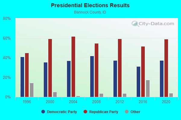
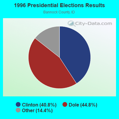
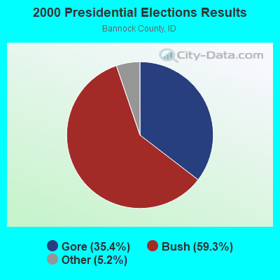
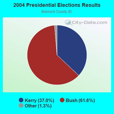
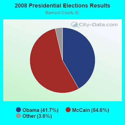

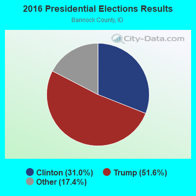
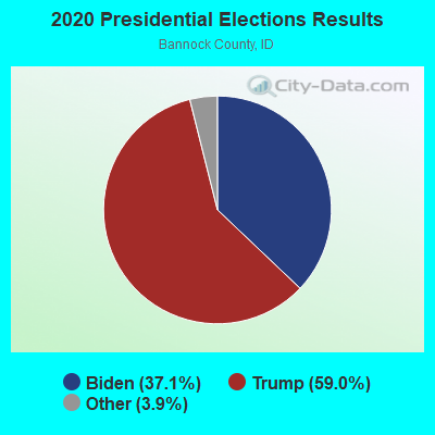
Graphs represent county-level data. Detailed 2008 Election Results
Religion statistics for South Bannock, ID (based on Bannock County data)
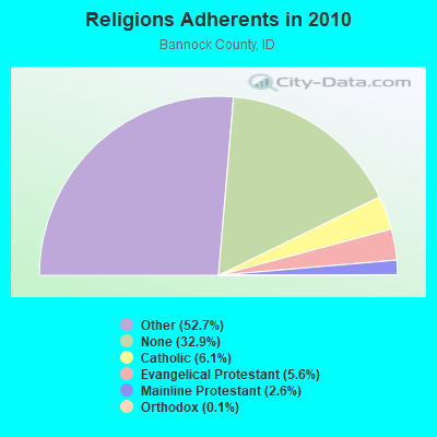
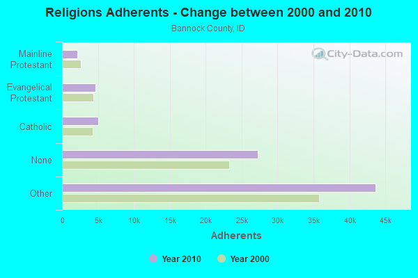
| Religion | Adherents | Congregations |
|---|---|---|
| Other | 43,667 | 121 |
| Catholic | 5,061 | 5 |
| Evangelical Protestant | 4,630 | 25 |
| Mainline Protestant | 2,152 | 10 |
| Orthodox | 85 | 1 |
| None | 27,244 | - |
Food Environment Statistics:
| Bannock County: | 1.13 / 10,000 pop. |
| Idaho: | 1.88 / 10,000 pop. |
| Bannock County: | 0.25 / 10,000 pop. |
| State: | 0.28 / 10,000 pop. |
| Bannock County: | 0.38 / 10,000 pop. |
| Idaho: | 0.53 / 10,000 pop. |
| Here: | 3.63 / 10,000 pop. |
| Idaho: | 3.87 / 10,000 pop. |
| Bannock County: | 5.88 / 10,000 pop. |
| Idaho: | 7.75 / 10,000 pop. |
| This county: | 7.2% |
| Idaho: | 7.7% |
| Bannock County: | 27.4% |
| Idaho: | 25.7% |
| Here: | 10.7% |
| State: | 11.7% |
Strongest AM radio stations in South Bannock:
- KBRV (790 AM; 5 kW; SODA SPRINGS, ID; Owner: CARIBOU BROADCASTING INC.)
- KZNR (690 AM; 10 kW; BLACKFOOT, ID; Owner: WESTERN COMMUNICATIONS, INC.)
- KALL (700 AM; 50 kW; NORTH SALT LAKE CITY, UT; Owner: CITICASTERS LICENSES, L.P.)
- KSEI (930 AM; 5 kW; POCATELLO, ID; Owner: PACIFIC EMPIRE COMMUNICATIONS CORP.)
- KIQN (1010 AM; 50 kW; TOOELE, UT)
- KBLI (1620 AM; 10 kW; BLACKFOOT, ID; Owner: WESTERN COMMUNICATIONS, INC.)
- KSL (1160 AM; 50 kW; SALT LAKE CITY, UT; Owner: BONNEVILLE HOLDING COMPANY)
- KSOS (800 AM; 10 kW; BRIGHAM CITY, UT; Owner: SIMMONS-SLC, LS, LLC)
- KVNU (610 AM; 5 kW; LOGAN, UT; Owner: SUN VALLEY RADIO,INC.)
- KID (590 AM; 5 kW; IDAHO FALLS, ID; Owner: CITICASTERS LICENSES, L.P.)
- KBOI (670 AM; 50 kW; BOISE, ID; Owner: CITADEL BROADCASTING COMPANY)
- KLGN (1390 AM; 5 kW; LOGAN, UT; Owner: SUN VALLEY RADIO, INC.)
- KRSV (1210 AM; 5 kW; AFTON, WY; Owner: WESTERN WYOMING RADIO, INC.)
Strongest FM radio stations in South Bannock:
- K299AH (107.7 FM; POCATELLO, ID; Owner: UNIVERSITY OF UTAH)
- KISU-FM (91.1 FM; POCATELLO, ID; Owner: IDAHO STATE UNIVERSITY)
- KLLP (98.5 FM; CHUBBUCK, ID; Owner: CITICASTERS LICENSES, L.P.)
- KRAR (106.9 FM; BRIGHAM CITY, UT; Owner: MERCURY BROADCASTING COMPANY, INC.)
- KMGI (102.5 FM; POCATELLO, ID; Owner: PACIFIC EMPIRE COMMUNICATIONS CORP.)
- KJQN (100.7 FM; BRIGHAM CITY, UT; Owner: SIMMONS-SLC, LS, LLC)
- KZBQ (93.7 FM; POCATELLO, ID; Owner: IDAHO WIRELESS CORPORATION)
- KPKY (94.9 FM; POCATELLO, ID; Owner: CITICASTERS LICENSES, L.P.)
- K249CM (97.7 FM; POCATELLO, ID; Owner: WESTERN COMMUNICATIONS, INC.)
- K266AF (101.1 FM; POCATELLO, ID; Owner: WESTERN COMMUNICATIONS, INC.)
- KORR (104.1 FM; AMERICAN FALLS, ID; Owner: IDAHO WIRELESS CORPORATION)
- K275AB (102.9 FM; FREEDOM, WY; Owner: LOWER STAR VALLEY TV ASSOCIATION)
- K220HI (91.9 FM; CLARKSTON, UT; Owner: CALVARY CHAPEL OF TWIN FALLS, INC.)
- KVFX (94.5 FM; LOGAN, UT; Owner: SUN VALLEY RADIO,INC.)
- KUSU-FM (91.5 FM; LOGAN, UT; Owner: UTAH STATE UNIV. OF AGRI. & APP. SCI)
- KLZX (95.9 FM; WESTON, ID; Owner: SUN VALLEY RADIO INC)
TV broadcast stations around South Bannock:
- K59BV (Channel 59; LAVA HOT SPRINGS, ID; Owner: STATE BOARD OF EDUCATION (IEPBS))
- KPVI (Channel 6; POCATELLO, ID; Owner: OREGON TRAIL BROADCASTING COMPANY)
- KFXP (Channel 31; POCATELLO, ID; Owner: COMPASS COMMUNICATION OF IDAHO, INC.)
- K13CO (Channel 13; FISH CREEK, ETC., ID; Owner: THE POST COMPANY)
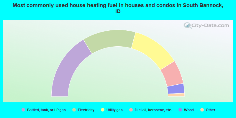
- 32.6%Bottled, tank, or LP gas
- 26.0%Electricity
- 23.7%Utility gas
- 11.5%Fuel oil, kerosene, etc.
- 4.7%Wood
- 0.8%Coal or coke
- 0.8%Other fuel
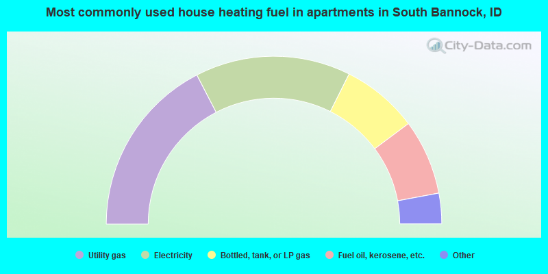
- 34.8%Utility gas
- 30.0%Electricity
- 14.8%Bottled, tank, or LP gas
- 14.5%Fuel oil, kerosene, etc.
- 3.4%Wood
- 2.1%Other fuel
- 0.3%No fuel used
South Bannock compared to Idaho state average:
- Unemployed percentage below state average.
- Black race population percentage below state average.
- Hispanic race population percentage significantly below state average.
- Median age below state average.
- Foreign-born population percentage significantly below state average.
- Renting percentage below state average.
- Length of stay since moving in significantly above state average.
- Number of rooms per house significantly below state average.
- House age significantly below state average.
- Institutionalized population percentage significantly above state average.
South Bannock on our top lists:
- #3 on the list of "Top 101 cities with largest percentage of females in occupations: other healthcare support occupations (population 5,000+)"
- #4 on the list of "Top 101 cities with largest percentage of males in occupations: secondary school teachers (population 5,000+)"
- #4 on the list of "Top 101 cities with largest percentage of males in industries: gasoline stations (population 5,000+)"
- #8 on the list of "Top 101 cities with largest percentage of males in industries: rail transportation (population 5,000+)"
- #9 on the list of "Top 101 cities with largest percentage of females in industries: gasoline stations (population 5,000+)"
- #13 on the list of "Top 101 cities with largest percentage of males in occupations: rail and water transportation workers (population 5,000+)"
- #16 on the list of "Top 101 cities with largest percentage of males in occupations: farmers and farm managers (population 5,000+)"
- #17 on the list of "Top 101 cities with largest percentage of females in occupations: extraction workers (population 5,000+)"
- #17 on the list of "Top 101 cities with largest percentage of males in occupations: preschool, kindergarten, elementary and middle school teachers (population 5,000+)"
- #30 on the list of "Top 101 cities with largest percentage of females in industries: farm supplies merchant wholesalers (population 5,000+)"
- #42 on the list of "Top 101 cities with largest percentage of males in industries: truck transportation (population 5,000+)"
- #44 on the list of "Top 101 cities with largest percentage of males in industries: chemicals (population 5,000+)"
- #68 on the list of "Top 100 cities with largest land areas (pop. 5,000+)"
- #75 on the list of "Top 101 cities with largest percentage of females in industries: petroleum and coal products (population 5,000+)"
- #81 on the list of "Top 101 cities with largest percentage of females in industries: food (population 5,000+)"
- #95 on the list of "Top 101 cities with largest percentage of males in industries: food and beverage stores (population 5,000+)"
- #96 on the list of "Top 101 cities with largest percentage of females in industries: computer and electronic products (population 5,000+)"
- #37 on the list of "Top 101 counties with highest percentage of residents voting for 3rd party candidates in the 2012 Presidential Election (pop. 50,000+)"
- #42 on the list of "Top 101 counties with the most Other congregations"
- #56 on the list of "Top 101 counties with the highest Particulate Matter (PM10) Annual air pollution readings in 2012 (µg/m3)"
- #57 on the list of "Top 101 counties with the most Other adherents"