South El Dorado, California
Submit your own pictures of this place and show them to the world
- OSM Map
- General Map
- Google Map
- MSN Map

| Males: 43,136 | |
| Females: 44,436 |
| Median resident age: | 39.7 years |
| California median age: | 33.3 years |
Zip code: 95667
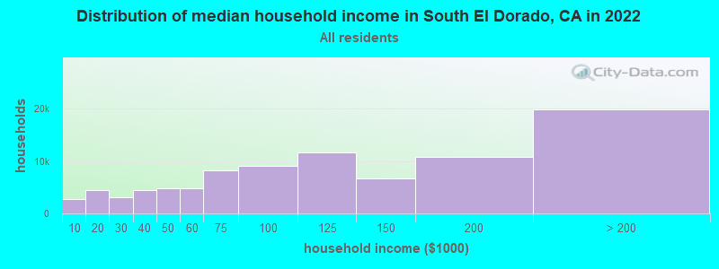
| South El Dorado: | $129,015 |
| CA: | $91,551 |
Estimated per capita income in 2022: $66,271 (it was $29,348 in 2000)
South El Dorado CCD income, earnings, and wages data
Estimated median house or condo value in 2022: $716,156 (it was $209,700 in 2000)
| South El Dorado: | $716,156 |
| CA: | $715,900 |
Mean prices in 2022: all housing units: $720,516; detached houses: $764,681; townhouses or other attached units: $549,812; in 2-unit structures: $512,382; in 3-to-4-unit structures: $311,556; in 5-or-more-unit structures: $365,271; mobile homes: $185,601; occupied boats, rvs, vans, etc.: over $1,000,000
South El Dorado, CA residents, houses, and apartments details
Detailed information about poverty and poor residents in South El Dorado, CA
Compare current foreclosures near South El Dorado, CA:
| Photo | Address | Area | Beds / Baths | Price | Details |
|---|---|---|---|---|---|

|
#1
Meadow Creek Rd
Placerville, CA 95667
|
1,359 sq. feet
|
2 baths 3 beds |
show details | |

|
#2
Windwalker Trl
Georgetown, CA 95634
|
- sq. feet
|
2 baths 3 beds |
show details | |

|
#3
Pollock Ave
Pollock Pines, CA 95726
|
1,331 sq. feet
|
2 baths 3 beds |
show details | |

|
#4
Stellar Ln
Pollock Pines, CA 95726
|
- sq. feet
|
1 baths 2 beds |
show details | |

|
#5
Allan Rd W
Volcano, CA 95689
|
1,680 sq. feet
|
2 baths 3 beds |
show details | |

|
#6
Pony Express Trl
Camino, CA 95709
|
1,320 sq. feet
|
1 baths 3 beds |
show details | |

|
#7
Westley Rd
Placerville, CA 95667
|
1,540 sq. feet
|
2 baths 3 beds |
show details | |

|
#8
Ponderosa Annex Rd
Sutter Creek, CA 95685
|
1,890 sq. feet
|
2 baths 3 beds |
show details | |

|
#9
Fallen Oak Trl
Pollock Pines, CA 95726
|
1,590 sq. feet
|
2 baths 2 beds |
show details | |

|
#10
Sly Park Rd
Pollock Pines, CA 95726
|
1,252 sq. feet
|
2 baths 4 beds |
show details |
| Photo | Address | Area | Beds / Baths | Price | Details |
|---|---|---|---|---|---|

|
#11
Marjorie Way
Pollock Pines, CA 95726
|
1,350 sq. feet
|
2 baths 2 beds |
show details | |

|
#12
Clapboard Road
Volcano, CA 95689
|
- sq. feet
|
2 baths 3 beds |
show details | |

|
#13
Nugget Ln
Placerville, CA 95667
|
1,584 sq. feet
|
2 baths 3 beds |
show details | |

|
#14
Meder Ct
Shingle Springs, CA 95682
|
3,572 sq. feet
|
3 baths 4 beds |
show details | |

|
#15
Fort Jim Rd
Placerville, CA 95667
|
2,300 sq. feet
|
2 baths 3 beds |
show details | |

|
#16
Molinetto Ct
El Dorado Hills, CA 95762
|
3,377 sq. feet
|
3 baths 4 beds |
show details | |

|
#17
Gregory Ln
Placerville, CA 95667
|
1,440 sq. feet
|
2 baths 2 beds |
show details | |

|
#18
Meadow Glen Dr
Grizzly Flats, CA 95636
|
1,260 sq. feet
|
2 baths 3 beds |
show details | |

|
#19
Dusty Ln
Placerville, CA 95667
|
2,357 sq. feet
|
3 baths 3 beds |
show details | |

|
#20
Idle Creek Dr
Shingle Springs, CA 95682
|
1,360 sq. feet
|
2 baths 3 beds |
show details |
| Photo | Address | Area | Beds / Baths | Price | Details |
|---|---|---|---|---|---|

|
#21
Emil Rd
Shingle Springs, CA 95682
|
2,243 sq. feet
|
2 baths 3 beds |
show details | |

|
#22
Woodsman Loop
Placerville, CA 95667
|
3,188 sq. feet
|
2 baths 2 beds |
show details | |

|
#23
Big Branch Rd
Shingle Springs, CA 95682
|
2,194 sq. feet
|
2 baths 3 beds |
show details | |

|
#24
N Shingle Rd
Shingle Springs, CA 95682
|
1,064 sq. feet
|
1 baths 2 beds |
show details | |

|
#25
French Creek Rd
Shingle Springs, CA 95682
|
1,992 sq. feet
|
3 baths 4 beds |
show details | |

|
#26
Idle Creek Dr
Shingle Springs, CA 95682
|
1,360 sq. feet
|
2 baths 3 beds |
show details | |

|
#27
Heagey Hill Rd
Placerville, CA 95667
|
2,396 sq. feet
|
2 baths 4 beds |
show details | |

|
#28
Longs Creek Trl
Pollock Pines, CA 95726
|
2,102 sq. feet
|
2 baths 2 beds |
show details | |

|
#29
Zinc Dr
Pollock Pines, CA 95726
|
1,997 sq. feet
|
2 baths 3 beds |
show details | |

|
#30
Kelsey Rd
Placerville, CA 95667
|
950 sq. feet
|
1 baths 2 beds |
show details |
| Photo | Address | Area | Beds / Baths | Price | Details |
|---|---|---|---|---|---|

|
#31
Springvale Rd
Placerville, CA 95667
|
1,565 sq. feet
|
1 baths 2 beds |
show details | |

|
#32
Swansboro Rd
Placerville, CA 95667
|
2,303 sq. feet
|
2 baths 4 beds |
show details | |

|
#33
Marjorie Way
Pollock Pines, CA 95726
|
621 sq. feet
|
1 baths 2 beds |
show details | |

|
#34
Deer Canyon Ct
Placerville, CA 95667
|
2,508 sq. feet
|
2 baths 2 beds |
show details | |

|
#35
Stope Dr
Placerville, CA 95667
|
2,025 sq. feet
|
2 baths 3 beds |
show details | |

|
#36
Stope Ct
Placerville, CA 95667
|
1,352 sq. feet
|
2 baths 3 beds |
show details | |

|
#37
Grassy Run Rd
Placerville, CA 95667
|
4,213 sq. feet
|
4 baths 5 beds |
show details | |

|
#38
Trotter Ln
Shingle Springs, CA 95682
|
1,700 sq. feet
|
2 baths 3 beds |
show details | |

|
#39
Jacarah Rd
Placerville, CA 95667
|
3,071 sq. feet
|
3 baths 4 beds |
show details | |

|
#40
Highcrest Dr
Shingle Springs, CA 95682
|
3,190 sq. feet
|
4 baths 4 beds |
show details |
| Photo | Address | Area | Beds / Baths | Price | Details |
|---|---|---|---|---|---|

|
#41
La Canada Dr
Shingle Springs, CA 95682
|
1,450 sq. feet
|
2 baths 3 beds |
show details | |

|
#42
Borders Dr
El Dorado Hills, CA 95762
|
2,436 sq. feet
|
2 baths 4 beds |
show details | |

|
#43
W Mitchell Mine Rd
Pine Grove, CA 95665
|
1,620 sq. feet
|
2 baths 3 beds |
show details | |

|
#44
San Marco Pl
El Dorado Hills, CA 95762
|
4,019 sq. feet
|
3 baths 4 beds |
show details | |

|
#45
Century Ln
Sutter Creek, CA 95685
|
2,347 sq. feet
|
3 baths 3 beds |
show details | |

|
#46
Marshall Rd
Garden Valley, CA 95633
|
1,574 sq. feet
|
1 baths 3 beds |
show details | |

|
#47
Mountain View Way
Volcano, CA 95689
|
3,060 sq. feet
|
2 baths 3 beds |
show details | |

|
#48
Gailey Ct
Shingle Springs, CA 95682
|
2,138 sq. feet
|
3 baths 4 beds |
show details | |

|
#49
Gateway Dr
Shingle Springs, CA 95682
|
1,600 sq. feet
|
2 baths 3 beds |
show details | |

|
Check over 1 million property listings on Foreclosure.com!
|
browse all offers | |||

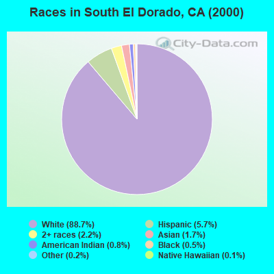
- 69,48288.7%White alone
- 4,5005.7%Hispanic
- 1,7202.2%Two or more races
- 1,3641.7%Asian alone
- 6350.8%American Indian alone
- 3710.5%Black alone
- 1340.2%Other race alone
- 900.1%Native Hawaiian and Other
Pacific Islander alone
 Recent articles from our blog. Our writers, many of them Ph.D. graduates or candidates, create easy-to-read articles on a wide variety of topics.

Current Local Time: PST time zone
Land area: 767.7 square miles.
Population density: 114 people per square mile (very low).
| South El Dorado CCD: | 0.9% ($1,847) |
| California: | 0.8% ($1,564) |
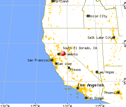
Nearest city with pop. 200,000+: Sacramento, CA  (40.4 miles , pop. 407,018).
Nearest city with pop. 1,000,000+: Los Angeles, CA (342.5 miles , pop. 3,694,820).
Nearest cities:
), ), ), ), ), Latitude: 38.66 N, Longitude: 120.73 W
Area code commonly used in this area: 530

| Here: | 4.4% |
| California: | 5.1% |
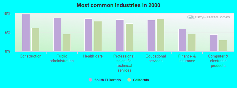
- Construction (9.9%)
- Public administration (8.9%)
- Health care (8.7%)
- Professional, scientific, technical services (8.4%)
- Educational services (8.3%)
- Finance & insurance (5.9%)
- Computer & electronic products (4.5%)
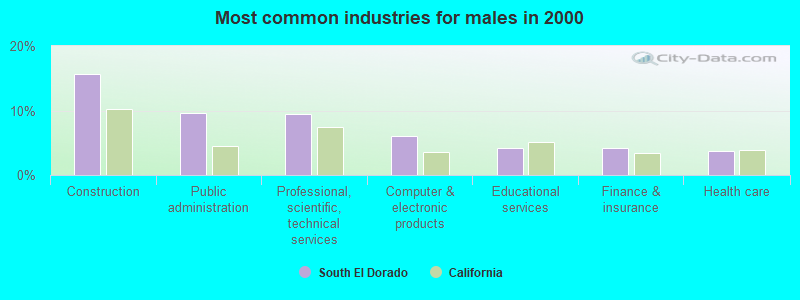
- Construction (15.7%)
- Public administration (9.6%)
- Professional, scientific, technical services (9.5%)
- Computer & electronic products (6.0%)
- Educational services (4.3%)
- Finance & insurance (4.2%)
- Health care (3.8%)
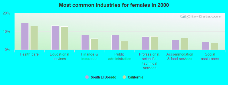
- Health care (14.7%)
- Educational services (13.2%)
- Finance & insurance (8.1%)
- Public administration (8.0%)
- Professional, scientific, technical services (7.1%)
- Accommodation & food services (5.3%)
- Social assistance (4.2%)
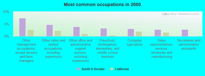
- Other management occupations, except farmers and farm managers (7.4%)
- Other sales and related occupations, including supervisors (4.8%)
- Other office and administrative support workers, including supervisors (3.9%)
- Preschool, kindergarten, elementary, and middle school teachers (3.3%)
- Computer specialists (3.1%)
- Sales representatives, services, wholesale and manufacturing (2.8%)
- Secretaries and administrative assistants (2.7%)
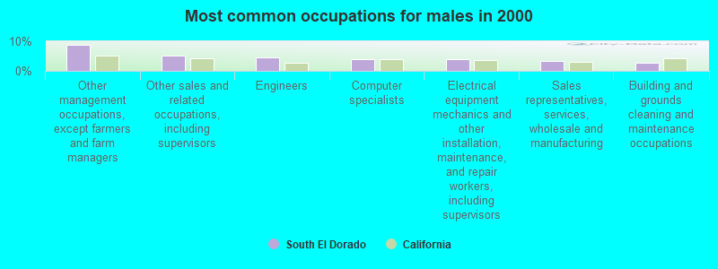
- Other management occupations, except farmers and farm managers (8.7%)
- Other sales and related occupations, including supervisors (5.3%)
- Engineers (4.6%)
- Computer specialists (4.0%)
- Electrical equipment mechanics and other installation, maintenance, and repair workers, including supervisors (3.8%)
- Sales representatives, services, wholesale and manufacturing (3.2%)
- Building and grounds cleaning and maintenance occupations (2.8%)
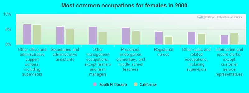
- Other office and administrative support workers, including supervisors (6.7%)
- Secretaries and administrative assistants (6.0%)
- Other management occupations, except farmers and farm managers (5.8%)
- Preschool, kindergarten, elementary, and middle school teachers (5.7%)
- Registered nurses (4.3%)
- Other sales and related occupations, including supervisors (4.2%)
- Information and record clerks, except customer service representatives (3.2%)
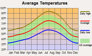
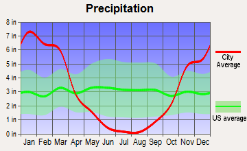
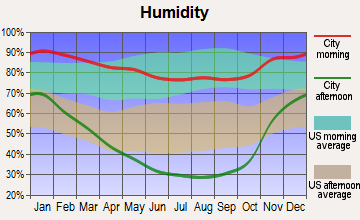
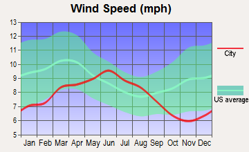
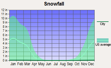
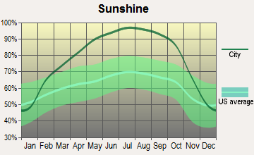
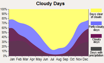
Average climate in South El Dorado, California
Based on data reported by over 4,000 weather stations
(lower is better)
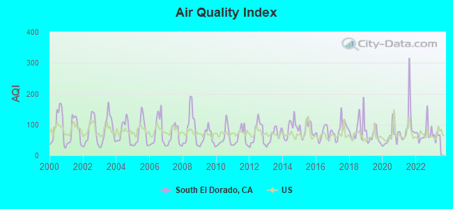
Air Quality Index (AQI) level in 2022 was 72.3. This is about average.
| City: | 72.3 |
| U.S.: | 72.6 |

Carbon Monoxide (CO) [ppm] level in 2005 was 0.183. This is better than average. Closest monitor was 6.6 miles away from the city center.
| City: | 0.183 |
| U.S.: | 0.251 |
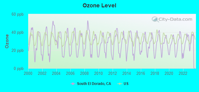
Ozone [ppb] level in 2022 was 27.7. This is better than average. Closest monitor was 6.5 miles away from the city center.
| City: | 27.7 |
| U.S.: | 33.3 |
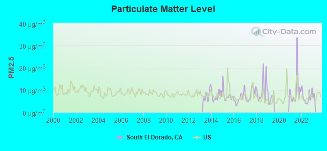
Particulate Matter (PM2.5) [µg/m3] level in 2022 was 6.92. This is about average. Closest monitor was 23.3 miles away from the city center.
| City: | 6.92 |
| U.S.: | 8.11 |
Earthquake activity:
South El Dorado-area historical earthquake activity is significantly above California state average. It is 7687% greater than the overall U.S. average.On 4/18/1906 at 13:12:21, a magnitude 7.9 (7.9 UK, Class: Major, Intensity: VIII - XII) earthquake occurred 131.2 miles away from South El Dorado center, causing $524,000,000 total damage
On 10/3/1915 at 06:52:48, a magnitude 7.6 (7.6 UK) earthquake occurred 214.2 miles away from South El Dorado center
On 12/21/1932 at 06:10:09, a magnitude 7.2 (7.2 UK) earthquake occurred 143.6 miles away from South El Dorado center
On 10/18/1989 at 00:04:15, a magnitude 7.1 (6.5 MB, 7.1 MS, 6.9 MW, 7.0 ML) earthquake occurred 121.3 miles away from the city center, causing 62 deaths (62 shaking deaths) and 3757 injuries, causing $1,305,032,704 total damage
On 7/21/1952 at 11:52:14, a magnitude 7.7 (7.7 UK) earthquake occurred 270.7 miles away from the city center, causing $50,000,000 total damage
On 11/4/1927 at 13:51:53, a magnitude 7.5 (7.5 UK) earthquake occurred 259.6 miles away from the city center
Magnitude types: body-wave magnitude (MB), local magnitude (ML), surface-wave magnitude (MS), moment magnitude (MW)
Natural disasters:
The number of natural disasters in El Dorado County (17) is near the US average (15).Major Disasters (Presidential) Declared: 8
Emergencies Declared: 2
Causes of natural disasters: Floods: 12, Mudslides: 6, Winter Storms: 6, Landslides: 5, Storms: 5, Fires: 2, Drought: 1, Heavy Rain: 1, Hurricane: 1, Other: 1 (Note: some incidents may be assigned to more than one category).
Hospitals and medical centers near South El Dorado:
- WESTERN SLOPE HEALTH CENTER (Nursing Home, about 6 miles away; PLACERVILLE, CA)
- MARSHALL MEDICAL CENTER (1-RH) Acute Care Hospitals (about 6 miles away; PLACERVILLE, CA)
- THE PINES AT PLACERVILLE HEALTHCARE CENTER (Nursing Home, about 6 miles away; PLACERVILLE, CA)
- MARSHALL HOME CARE (Home Health Center, about 6 miles away; PLACERVILLE, CA)
- SNOWLINE HOSPICE OF EL DORADO, INC (Hospital, about 6 miles away; DIAMOND SPRINGS, CA)
- GOLD COUNTRY HEALTH CENTER (Nursing Home, about 6 miles away; PLACERVILLE, CA)
- CAMERON PARK DIALYSIS (Dialysis Facility, about 13 miles away; CAMERON PARK, CA)
Amtrak stations near South El Dorado:
- 6 miles: PLACERVILLE (222 MAIN ST.) - Bus Station . Services: fully wheelchair accessible, public payphones, full-service food facilities, free short-term parking, call for taxi service.
- 13 miles: CAMERON PARK (US HWY. 50 & CAMERON PARK DR.) - Bus Station . Services: fully wheelchair accessible, enclosed waiting area, public restrooms, public payphones, full-service food facilities, free short-term parking.
Colleges/universities with over 2000 students nearest to South El Dorado:
- Folsom Lake College (about 22 miles; Folsom, CA; Full-time enrollment: 5,308)
- Sierra College (about 28 miles; Rocklin, CA; FT enrollment: 11,488)
- American River College (about 34 miles; Sacramento, CA; FT enrollment: 20,452)
- California State University-Sacramento (about 38 miles; Sacramento, CA; FT enrollment: 22,234)
- Cosumnes River College (about 40 miles; Sacramento, CA; FT enrollment: 9,327)
- Sacramento City College (about 42 miles; Sacramento, CA; FT enrollment: 15,963)
- University of Phoenix-Sacramento Valley Campus (about 43 miles; Sacramento, CA; FT enrollment: 2,855)
Points of interest:
Notable locations in South El Dorado: Carson Creek School (A), Cedarville (B), D'Agostini Ranch (C), White (D), Lumberyard Ranger Station (E), Lawrence Mill (F), Sly Park Guard Station (G), Podesta Camp (H), Allen Camp (I), Capps Crossing Campground (J), Rescue (K), Devils Garden Vista (L), Leek Spring Lookout (M), Sly Park Recreation Site (N), Eight Mile House (O), Tuman Mill (P), Sierra Ski Ranch (Q), Thirty-nine Mile Campground (R), Miller Ranch (S), Logtown (T). Display/hide their locations on the map
Shopping Centers: Winery Plaza Shopping Center (1), Shingle Spring Plaza Shopping Center (2), Goldorado Shopping Center (3), French Creek Shopping Center (4), Durock Shopping Center (5), Cameron Oaks Shopping Center (6), Cambridge Plaza Shops Shopping Center (7), Burke Junction Shopping Center (8), El Dorado Hills Village Center Shopping Center (9). Display/hide their locations on the map
Cemeteries: Jayhawk Cemetery (1), Oak Hill Cemetery (2), Clarksville Cemetery (3), Indian Diggings Cemetery (4), Chinese Cemetery (5), Andreason Cemetery (6). Display/hide their locations on the map
Lakes, reservoirs, and swamps: Lake Margaret (A), Shealor Lakes (B), Lake Audrian (C), Cody Lake (D), Bass Lake (E), Twin Gulch Fire Tank (F), Harrel Fire Tank (G), Myers Fire Tank (H). Display/hide their locations on the map
Streams, rivers, and creeks: Clark Creek (A), Crocker Creek (B), Deadman Creek (C), Diamond Creek (D), Fanny Creek (E), Flat Creek (F), French Creek (G), Gilmore Creek (H), Girard Creek (I). Display/hide their locations on the map
Parks in South El Dorado include: Old Fort Jim Historical Marker (1), Art Weisburg Park (2), Browns Ravine Recreation Area (3), Crescent Ridge Park (4), El Dorado Hills Archery Range (5), El Dorado Hills Community Park (6), Pony Express Station Historic Site (7), Ridgeview Park (8), Saint Andrews Park (9). Display/hide their locations on the map
| This place: | 2.7 people |
| California: | 2.9 people |
| This place: | 76.9% |
| Whole state: | 68.7% |
| This place: | 5.1% |
| Whole state: | 7.2% |
Likely homosexual households (counted as self-reported same-sex unmarried-partner households)
- Lesbian couples: 0.4% of all households
- Gay men: 0.3% of all households
| This place: | 5.2% |
| Whole state: | 14.2% |
| This place: | 2.3% |
| Whole state: | 6.3% |
People in group quarters in South El Dorado in 2010:
- 127 people in other noninstitutional facilities
- 99 people in nursing facilities/skilled-nursing facilities
- 19 people in group homes intended for adults
- 19 people in workers' group living quarters and job corps centers
- 17 people in residential treatment centers for juveniles (non-correctional)
- 14 people in emergency and transitional shelters (with sleeping facilities) for people experiencing homelessness
People in group quarters in South El Dorado in 2000:
- 98 people in nursing homes
- 67 people in other noninstitutional group quarters
- 18 people in unknown juvenile institutions
- 17 people in homes for the mentally ill
- 14 people in other group homes
- 7 people in homes or halfway houses for drug/alcohol abuse
For population 15 years and over in South El Dorado:
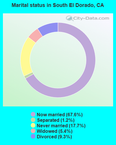
- Never married: 17.7%
- Now married: 67.6%
- Separated: 1.2%
- Widowed: 5.4%
- Divorced: 9.3%
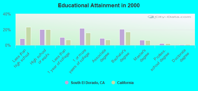
For population 25 years and over in South El Dorado:
- High school or higher: 91.5%
- Bachelor's degree or higher: 30.6%
- Graduate or professional degree: 9.9%
- Unemployed: 4.4%
- Mean travel time to work (commute): 31.8 minutes
| Here: | 9.3 |
| California average: | 16.1 |
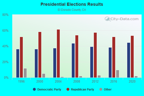
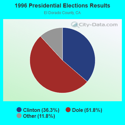
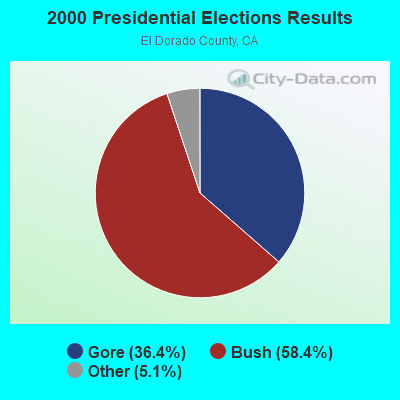
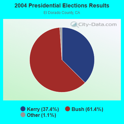
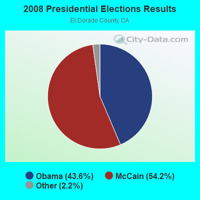
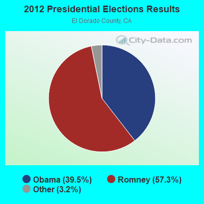
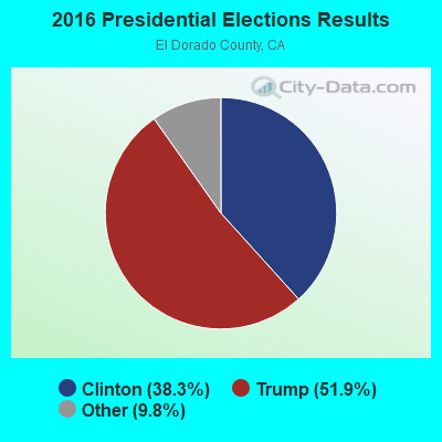
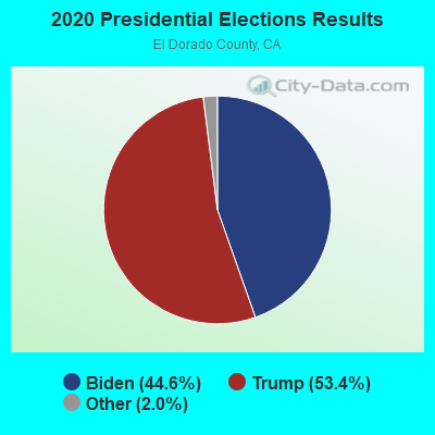
Graphs represent county-level data. Detailed 2008 Election Results
Religion statistics for South El Dorado, CA (based on El Dorado County data)
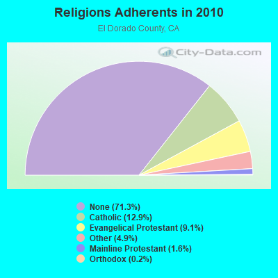

| Religion | Adherents | Congregations |
|---|---|---|
| Catholic | 23,298 | 6 |
| Evangelical Protestant | 16,538 | 69 |
| Other | 8,928 | 30 |
| Mainline Protestant | 2,937 | 11 |
| Orthodox | 315 | 2 |
| None | 129,042 | - |
Food Environment Statistics:
| El Dorado County: | 1.88 / 10,000 pop. |
| State: | 2.14 / 10,000 pop. |
| Here: | 0.06 / 10,000 pop. |
| California: | 0.04 / 10,000 pop. |
| Here: | 0.97 / 10,000 pop. |
| State: | 0.62 / 10,000 pop. |
| El Dorado County: | 2.28 / 10,000 pop. |
| California: | 1.49 / 10,000 pop. |
| El Dorado County: | 9.87 / 10,000 pop. |
| State: | 7.42 / 10,000 pop. |
| El Dorado County: | 6.7% |
| California: | 7.3% |
| El Dorado County: | 19.9% |
| California: | 21.3% |
| El Dorado County: | 13.1% |
| California: | 17.9% |
Strongest AM radio stations in South El Dorado:
- KHTK (1140 AM; 50 kW; SACRAMENTO, CA; Owner: INFINITY RADIO SUBSIDIARY OPERATIONS INC.)
- KSTE (650 AM; 25 kW; RANCHO CORDOVA, CA; Owner: AMFM RADIO LICENSES, L.L.C.)
- KFIA (710 AM; 25 kW; CARMICHAEL, CA; Owner: VISTA BROADCASTING INC.)
- KAHI (950 AM; 10 kW; AUBURN, CA; Owner: IHR EDUCATIONAL BROADCASTING)
- KFBK (1530 AM; 50 kW; SACRAMENTO, CA; Owner: AMFM RADIO LICENSES, L.L.C.)
- KCBC (770 AM; 50 kW; RIVERBANK, CA; Owner: KIERTRON, INC.)
- KLIB (1110 AM; 10 kW; ROSEVILLE, CA; Owner: WAY BROADCASTING, INC.)
- KFSG (1690 AM; 10 kW; ROSEVILLE, CA; Owner: WAY BROADCASTING, INC.)
- KKOH (780 AM; 50 kW; RENO, NV; Owner: CITADEL BROADCASTING COMPANY)
- KEBR (1210 AM; 5 kW; ROCKLIN, CA; Owner: FAMILY STATIONS, INC.)
- KCBS (740 AM; 50 kW; SAN FRANCISCO, CA; Owner: INFINITY BROADCASTING OPERATIONS, INC.)
- KTKZ (1380 AM; 5 kW; SACRAMENTO, CA; Owner: VISTA BROADCASTING, INC.)
- KNBR (680 AM; 50 kW; SAN FRANCISCO, CA; Owner: KNBR LICO, INC.)
Strongest FM radio stations in South El Dorado:
- KCCL-FM (101.9 FM; SHINGLE SPRINGS, CA; Owner: ENTRAVISION HOLDINGS, LLC)
- KZSA (92.1 FM; PLACERVILLE, CA; Owner: FIRST BROADCASTING INVESTMENTS, L.P.)
- KOSL (94.3 FM; JACKSON, CA; Owner: HBC LICENSE CORPORATION)
- KWYL (102.9 FM; SOUTH LAKE TAHOE, CA; Owner: CITADEL BROADCASTING COMPANY)
- KXCL (103.9 FM; YUBA CITY, CA; Owner: HARLAN COMMUNICATIONS, INC.)
- KEDR (88.1 FM; SACRAMENTO, CA; Owner: FAMILY STATIONS, INC.)
- KTHX-FM (100.1 FM; DAYTON, NV; Owner: NM LICENSING, LLC)
- KRNO (106.9 FM; INCLINE VILLAGE, NV; Owner: AMERICOM LAS VEGAS LIMITED PARTNERSHIP)
- KODS (103.7 FM; CARNELIAN BAY, CA; Owner: AMERICOM, A CALIFORNIA LIMITED PARTNERSHIP)
- KLCA (96.5 FM; TAHOE CITY, CA; Owner: AMERICOM LAS VEGAS LIMITED PARTNERSHIP)
- KKTO (90.5 FM; TAHOE CITY, CA; Owner: CALIFORNIA STATE UNIVERSITY)
- KDOT (104.5 FM; RENO, NV; Owner: LOTUS RADIO CORP.)
- KOZZ-FM (105.7 FM; RENO, NV; Owner: LOTUS RADIO CORP.)
- KTKE (101.5 FM; TRUCKEE, CA; Owner: TRUCKSTER BROADCASTING, INC.)
- KSVL (92.3 FM; SMITH, NV; Owner: DONEGAL ENTERPRISES)
- KHYL (101.1 FM; AUBURN, CA; Owner: AMFM RADIO LICENSES, L.L.C.)
- KNCI (105.1 FM; SACRAMENTO, CA; Owner: INFINITY RADIO SUBSIDIARY OPERATIONS INC.)
- KBYN (95.9 FM; ARNOLD, CA; Owner: KBYN, INC.)
- KRXQ (98.5 FM; SACRAMENTO, CA; Owner: ENTERCOM SACRAMENTO LICENSE, LLC)
- KSRN (107.7 FM; KINGS BEACH, CA; Owner: NM LICENSING, LLC)
TV broadcast stations around South El Dorado:
- KMMK-LP (Channel 14; SACRAMENTO, CA; Owner: CABALLERO TELEVISION TEXAS, L.L.C.)
- KGTN-LP (Channel 62; PLACERVILLE, CA; Owner: PRAISE THE LORD STUDIO CHAPEL)
- KEZT-CA (Channel 23; SACRAMENTO, CA; Owner: TELEFUTURA SACRAMENTO LLC)
- KSPX (Channel 29; SACRAMENTO, CA; Owner: PAXSON SACRAMENTO LICENSE, INC.)
- KTXL (Channel 40; SACRAMENTO, CA; Owner: CHANNEL 40, INC.)
- KQCA (Channel 58; STOCKTON, CA; Owner: KCRA HEARST-ARGYLE TELEVISION, INC.)
- KOVR (Channel 13; STOCKTON, CA; Owner: SCI - SACRAMENTO LICENSEE, LLC)
- KXTV (Channel 10; SACRAMENTO, CA; Owner: KXTV, INC.)
- KCRA-TV (Channel 3; SACRAMENTO, CA; Owner: KCRA HEARST-ARGYLE TELEVISION, INC.)
- KUVS (Channel 19; MODESTO, CA; Owner: KUVS LICENSE PARTNERSHIP, G.P.)
- KVIE (Channel 6; SACRAMENTO, CA; Owner: KVIE, INC.)
- KMAX-TV (Channel 31; SACRAMENTO, CA; Owner: UPN STATIONS GROUP INC.)
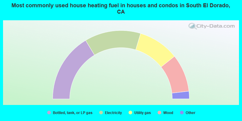
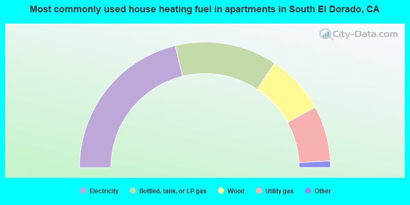
- 32.7%Bottled, tank, or LP gas
- 26.6%Electricity
- 19.3%Utility gas
- 17.8%Wood
- 2.3%Other fuel
- 1.1%Fuel oil, kerosene, etc.
- 0.1%No fuel used
- 42.4%Electricity
- 26.3%Bottled, tank, or LP gas
- 15.4%Wood
- 14.2%Utility gas
- 1.1%Fuel oil, kerosene, etc.
- 0.7%Other fuel
South El Dorado compared to California state average:
- Unemployed percentage significantly below state average.
- Black race population percentage significantly below state average.
- Hispanic race population percentage significantly below state average.
- Median age above state average.
- Foreign-born population percentage significantly below state average.
- Renting percentage below state average.
- Length of stay since moving in significantly above state average.
- Number of rooms per house significantly below state average.
- House age significantly below state average.
South El Dorado on our top lists:
- #2 on the list of "Top 101 cities with largest percentage of females in industries: pharmacies and drug stores (population 50,000+)"
- #3 on the list of "Top 101 cities with largest percentage of females in occupations: other management occupations except farmers and farm managers (population 50,000+)"
- #4 on the list of "Top 101 cities with largest percentage of females in occupations: mathematical science occupations (population 50,000+)"
- #5 on the list of "Top 101 cities with largest percentage of females in industries: office supplies and stationery stores (population 50,000+)"
- #5 on the list of "Top 101 cities with largest percentage of males in industries: sewing, needlework, and piece goods stores (population 50,000+)"
- #5 on the list of "Top 101 cities with largest percentage of males in occupations: special education teachers (population 50,000+)"
- #6 on the list of "Top 101 cities with largest percentage of females in occupations: judges, magistrates, and other judicial workers (population 50,000+)"
- #6 on the list of "Top 101 cities with largest percentage of males in industries: computer and electronic products (population 50,000+)"
- #6 on the list of "Top 101 cities with largest percentage of females in occupations: electricians (population 50,000+)"
- #6 on the list of "Top 101 cities with largest percentage of males in industries: wood products (population 50,000+)"
- #7 on the list of "Top 101 cities with largest percentage of males in occupations: mathematical science occupations (population 50,000+)"
- #9 on the list of "Top 100 cities with largest land areas (pop. 50,000+)"
- #10 on the list of "Top 101 cities with largest percentage of females in industries: computer and electronic products (population 50,000+)"
- #13 on the list of "Top 101 cities with largest percentage of females in industries: beverage and tobacco products (population 50,000+)"
- #15 on the list of "Top 101 cities with largest percentage of males in industries: miscellaneous nondurable goods merchant wholesalers (population 50,000+)"
- #15 on the list of "Top 101 cities with largest percentage of females in industries: electronic shopping and mail-order houses (population 50,000+)"
- #16 on the list of "Top 101 cities with largest percentage of males in industries: rail transportation (population 50,000+)"
- #17 on the list of "Top 101 cities with largest percentage of females in industries: recyclable material merchant wholesalers (population 50,000+)"
- #18 on the list of "Top 101 cities with largest percentage of females in industries: fuel dealers (population 50,000+)"
- #18 on the list of "Top 101 cities with largest percentage of females in industries: building material and garden equipment and supplies dealers (population 50,000+)"
- #19 on the list of "Top 101 counties with the lowest number of births per 1000 residents 2007-2013"
- #54 on the list of "Top 101 counties with the largest decrease in the number of births per 1000 residents 2000-2006 to 2007-2013 (pop 50,000+)"
- #84 on the list of "Top 101 counties with highest percentage of residents voting for 3rd party candidates in the 2012 Presidential Election (pop. 50,000+)"