South Sutter, California
Submit your own pictures of this place and show them to the world
- OSM Map
- General Map
- Google Map
- MSN Map

| Males: 1,649 | |
| Females: 1,475 |
| Median resident age: | 39.6 years |
| California median age: | 33.3 years |
Zip code: 95668
| South Sutter: | $72,585 |
| CA: | $91,551 |
Estimated per capita income in 2022: $36,693 (it was $19,490 in 2000)
South Sutter CCD income, earnings, and wages data
Estimated median house or condo value in 2022: $594,203 (it was $164,500 in 2000)
| South Sutter: | $594,203 |
| CA: | $715,900 |
Mean prices in 2022: all housing units: $477,964; detached houses: $500,791; townhouses or other attached units: $492,332; in 2-unit structures: over $1,000,000; in 3-to-4-unit structures: $172,512; in 5-or-more-unit structures: $165,844; mobile homes: $158,826; occupied boats, rvs, vans, etc.: $69,481
Detailed information about poverty and poor residents in South Sutter, CA
Compare current foreclosures near South Sutter, CA:
| Photo | Address | Area | Beds / Baths | Price | Details |
|---|---|---|---|---|---|

|
#1
Camp Far West Rd
Sheridan, CA 95681
|
1,404 sq. feet
|
2 baths 3 beds |
$330,000
|
show details |

|
#2
San Marin Ln
Sacramento, CA 95835
|
1,399 sq. feet
|
2 baths 2 beds |
show details | |

|
#3
Pinehurst Dr
Roseville, CA 95747
|
4,723 sq. feet
|
3 baths 5 beds |
show details | |

|
#4
Black Eagle Dr
Antelope, CA 95843
|
1,256 sq. feet
|
2 baths 3 beds |
show details | |

|
#5
Oslo Ct
Antelope, CA 95843
|
1,765 sq. feet
|
3 baths 4 beds |
show details | |

|
#6
Norby Ct
Olivehurst, CA 95961
|
3,210 sq. feet
|
3 baths 5 beds |
show details | |

|
#7
Greg Thatch Cir
Sacramento, CA 95835
|
- sq. feet
|
- baths - beds |
$500,000
|
show details |

|
#8
Erle Rd
Marysville, CA 95901
|
1,224 sq. feet
|
1 baths 3 beds |
show details | |

|
#9
Hunters Glen Pl
Antelope, CA 95843
|
2,244 sq. feet
|
3 baths 4 beds |
show details | |

|
#10
Red Clover Way
Lincoln, CA 95648
|
1,343 sq. feet
|
2 baths 3 beds |
show details |
| Photo | Address | Area | Beds / Baths | Price | Details |
|---|---|---|---|---|---|

|
#11
Vinci Ave
Sacramento, CA 95838
|
- sq. feet
|
2 baths 4 beds |
show details | |

|
#12
Jack London Ct
Roseville, CA 95747
|
2,015 sq. feet
|
3 baths 4 beds |
show details | |

|
#13
Centinella Dr
North Highlands, CA 95660
|
1,286 sq. feet
|
2 baths 4 beds |
show details | |

|
#14
246 Lariat
Lincoln, CA 95648
|
1,815 sq. feet
|
2 baths 2 beds |
show details | |

|
#15
Perrara Ct
Roseville, CA 95747
|
- sq. feet
|
2 baths 4 beds |
show details | |

|
#16
Moonstone Ave
Sacramento, CA 95835
|
2,069 sq. feet
|
2 baths 4 beds |
show details | |

|
#17
K St
Rio Linda, CA 95673
|
999 sq. feet
|
1 baths 2 beds |
show details | |

|
#18
Zachis Way
Antelope, CA 95843
|
1,577 sq. feet
|
2 baths 3 beds |
show details | |

|
#19
Zenith Dr
Citrus Heights, CA 95621
|
1,232 sq. feet
|
2 baths 3 beds |
show details | |

|
#20
Barnwood Ln
Roseville, CA 95747
|
3,120 sq. feet
|
3 baths 5 beds |
show details |
| Photo | Address | Area | Beds / Baths | Price | Details |
|---|---|---|---|---|---|

|
#21
Bainbridge Dr
North Highlands, CA 95660
|
901 sq. feet
|
1 baths 3 beds |
show details | |

|
#22
Long Warf Pl
Sacramento, CA 95835
|
1,722 sq. feet
|
3 baths 3 beds |
show details | |

|
#23
Talon Rd
Rocklin, CA 95765
|
1,806 sq. feet
|
2 baths 4 beds |
show details | |

|
#24
Mount Darwin Ct
Roseville, CA 95747
|
2,573 sq. feet
|
2 baths 4 beds |
show details | |

|
#25
Pine Nut Way
Sacramento, CA 95838
|
1,409 sq. feet
|
2 baths 3 beds |
show details | |

|
#26
Woodside Dr
Rocklin, CA 95677
|
1,080 sq. feet
|
1 baths 2 beds |
show details | |

|
#27
G St
Rio Linda, CA 95673
|
1,328 sq. feet
|
1 baths 3 beds |
show details | |

|
#28
Calleystone Way
Antelope, CA 95843
|
1,513 sq. feet
|
2 baths 3 beds |
show details | |

|
#29
Acacia Way
Olivehurst, CA 95961
|
1,187 sq. feet
|
2 baths 4 beds |
show details | |

|
#30
6th St
Rio Linda, CA 95673
|
1,030 sq. feet
|
1 baths 2 beds |
show details |
| Photo | Address | Area | Beds / Baths | Price | Details |
|---|---|---|---|---|---|

|
#31
Walerga Rd Unit 1097
Antelope, CA 95843
|
836 sq. feet
|
2 baths 2 beds |
show details | |

|
#32
Walerga Rd Unit 1146
Antelope, CA 95843
|
836 sq. feet
|
2 baths 2 beds |
show details | |

|
#33
Hidalgo Cir
Roseville, CA 95747
|
1,283 sq. feet
|
2 baths 3 beds |
show details | |

|
#34
Gibson Dr Apt 1611
Roseville, CA 95678
|
851 sq. feet
|
1 baths 1 beds |
show details | |

|
#35
Lilac Ln
Rio Linda, CA 95673
|
1,120 sq. feet
|
1 baths 3 beds |
show details | |

|
#36
Walerga Rd Unit 1217
Antelope, CA 95843
|
1,193 sq. feet
|
2 baths 3 beds |
show details | |

|
#37
La Cadena Way
Sacramento, CA 95835
|
2,222 sq. feet
|
2 baths 4 beds |
show details | |

|
#38
Trehowell Dr
Roseville, CA 95678
|
2,140 sq. feet
|
3 baths 4 beds |
show details | |

|
#39
Golden Ring Way
Antelope, CA 95843
|
2,131 sq. feet
|
3 baths 4 beds |
show details | |

|
#40
Winthrop Ct
North Highlands, CA 95660
|
1,338 sq. feet
|
2 baths 4 beds |
show details |
| Photo | Address | Area | Beds / Baths | Price | Details |
|---|---|---|---|---|---|

|
#41
Oregon Way
Yuba City, CA 95991
|
- sq. feet
|
2 baths 4 beds |
show details | |

|
#42
Summit Dr
Rocklin, CA 95765
|
2,113 sq. feet
|
2 baths 4 beds |
show details | |

|
#43
Miners Cir
Rocklin, CA 95765
|
1,578 sq. feet
|
2 baths 3 beds |
show details | |

|
#44
Parker St
Rocklin, CA 95765
|
1,793 sq. feet
|
2 baths 4 beds |
show details | |

|
#45
N Country Dr
Antelope, CA 95843
|
1,428 sq. feet
|
2 baths 3 beds |
show details | |

|
#46
Butte View Ct
Rocklin, CA 95765
|
1,626 sq. feet
|
2 baths 3 beds |
show details | |

|
#47
Falcon View Dr
Antelope, CA 95843
|
1,465 sq. feet
|
2 baths 3 beds |
show details | |

|
#48
Falcon View Dr
Antelope, CA 95843
|
1,681 sq. feet
|
2 baths 3 beds |
show details | |

|
#49
Falcon View Dr
Antelope, CA 95843
|
1,137 sq. feet
|
2 baths 3 beds |
show details | |

|
Check over 1 million property listings on Foreclosure.com!
|
browse all offers | |||

- 2,08777.2%White alone
- 43216.0%Hispanic
- 702.6%Two or more races
- 582.1%Asian alone
- 381.4%American Indian alone
- 140.5%Black alone
- 20.07%Native Hawaiian and Other
Pacific Islander alone - 20.07%Other race alone

 Recent articles from our blog. Our writers, many of them Ph.D. graduates or candidates, create easy-to-read articles on a wide variety of topics.

Current Local Time: PST time zone
Land area: 131.9 square miles.
Population density: 24 people per square mile (very low).

| South Sutter CCD: | 0.7% ($1,094) |
| California: | 0.8% ($1,564) |
Nearest city with pop. 50,000+: Roseville, CA  (15.6 miles , pop. 79,921).
Nearest city with pop. 200,000+: Sacramento, CA (23.6 miles , pop. 407,018).
Nearest city with pop. 1,000,000+: Los Angeles, CA (375.5 miles , pop. 3,694,820).
Nearest cities:
), ), ), ), ), ), )Latitude: 38.89 N, Longitude: 121.51 W
Area code commonly used in this area: 530


| Here: | 8.7% |
| California: | 5.1% |

- Agriculture, forestry, fishing & hunting (19.1%)
- Construction (11.3%)
- Educational services (10.1%)
- Public administration (7.1%)
- Health care (4.3%)
- Professional, scientific, technical services (3.7%)
- Administrative & support & waste management services (2.9%)

- Agriculture, forestry, fishing & hunting (27.0%)
- Construction (17.3%)
- Public administration (5.9%)
- Administrative & support & waste management services (3.9%)
- Educational services (3.4%)
- Professional, scientific, technical services (3.4%)
- Groceries & related products merchant wholesalers (2.7%)

- Educational services (20.5%)
- Health care (9.0%)
- Public administration (9.0%)
- Agriculture, forestry, fishing & hunting (6.8%)
- Finance & insurance (4.6%)
- Professional, scientific, technical services (4.2%)
- Accommodation & food services (2.4%)

- Farmers and farm managers (8.6%)
- Agricultural workers, including supervisors (7.2%)
- Other sales and related occupations, including supervisors (5.6%)
- Other management occupations, except farmers and farm managers (4.1%)
- Other office and administrative support workers, including supervisors (3.8%)
- Other production occupations, including supervisors (3.8%)
- Electrical equipment mechanics and other installation, maintenance, and repair workers, including supervisors (3.2%)

- Farmers and farm managers (12.7%)
- Agricultural workers, including supervisors (10.2%)
- Other management occupations, except farmers and farm managers (5.3%)
- Other sales and related occupations, including supervisors (4.9%)
- Electrical equipment mechanics and other installation, maintenance, and repair workers, including supervisors (4.7%)
- Vehicle and mobile equipment mechanics, installers, and repairers (4.6%)
- Laborers and material movers, hand (4.3%)

- Other office and administrative support workers, including supervisors (8.1%)
- Other sales and related occupations, including supervisors (6.6%)
- Bookkeeping, accounting, and auditing clerks (5.5%)
- Preschool, kindergarten, elementary, and middle school teachers (4.6%)
- Secretaries and administrative assistants (4.6%)
- Material recording, scheduling, dispatching, and distributing workers (4.6%)
- Other production occupations, including supervisors (3.7%)
Average climate in South Sutter, California
Based on data reported by over 4,000 weather stations


(lower is better)

Air Quality Index (AQI) level in 2023 was 71.0. This is about average.
| City: | 71.0 |
| U.S.: | 72.6 |

Carbon Monoxide (CO) [ppm] level in 2021 was 0.194. This is better than average. Closest monitor was 13.0 miles away from the city center.
| City: | 0.194 |
| U.S.: | 0.251 |

Nitrogen Dioxide (NO2) [ppb] level in 2022 was 6.52. This is worse than average. Closest monitor was 13.0 miles away from the city center.
| City: | 6.52 |
| U.S.: | 5.11 |

Sulfur Dioxide (SO2) [ppb] level in 2022 was 0.207. This is significantly better than average. Closest monitor was 14.5 miles away from the city center.
| City: | 0.207 |
| U.S.: | 1.515 |

Ozone [ppb] level in 2023 was 29.9. This is about average. Closest monitor was 3.2 miles away from the city center.
| City: | 29.9 |
| U.S.: | 33.3 |

Particulate Matter (PM10) [µg/m3] level in 2022 was 19.4. This is about average. Closest monitor was 11.1 miles away from the city center.
| City: | 19.4 |
| U.S.: | 19.2 |

Particulate Matter (PM2.5) [µg/m3] level in 2023 was 5.83. This is better than average. Closest monitor was 16.8 miles away from the city center.
| City: | 5.83 |
| U.S.: | 8.11 |

Lead (Pb) [µg/m3] level in 2023 was 0.00140. This is significantly better than average. Closest monitor was 16.8 miles away from the city center.
| City: | 0.00140 |
| U.S.: | 0.00931 |
Earthquake activity:
South Sutter-area historical earthquake activity is significantly above California state average. It is 7470% greater than the overall U.S. average.On 4/18/1906 at 13:12:21, a magnitude 7.9 (7.9 UK, Class: Major, Intensity: VIII - XII) earthquake occurred 101.6 miles away from South Sutter center, causing $524,000,000 total damage
On 10/3/1915 at 06:52:48, a magnitude 7.6 (7.6 UK) earthquake occurred 240.7 miles away from South Sutter center
On 10/18/1989 at 00:04:15, a magnitude 7.1 (6.5 MB, 7.1 MS, 6.9 MW, 7.0 ML) earthquake occurred 124.2 miles away from the city center, causing 62 deaths (62 shaking deaths) and 3757 injuries, causing $1,305,032,704 total damage
On 1/31/1922 at 13:17:28, a magnitude 7.6 (7.6 UK) earthquake occurred 248.3 miles away from South Sutter center
On 4/25/1992 at 18:06:04, a magnitude 7.2 (6.3 MB, 7.1 MS, 7.2 MW, 7.1 MW, Depth: 9.4 mi) earthquake occurred 169.3 miles away from the city center, causing $75,000,000 total damage
On 12/21/1932 at 06:10:09, a magnitude 7.2 (7.2 UK) earthquake occurred 187.0 miles away from South Sutter center
Magnitude types: body-wave magnitude (MB), local magnitude (ML), surface-wave magnitude (MS), moment magnitude (MW)
Natural disasters:
The number of natural disasters in Sutter County (15) is near the US average (15).Major Disasters (Presidential) Declared: 10
Emergencies Declared: 2
Causes of natural disasters: Floods: 11, Storms: 5, Winter Storms: 5, Landslides: 3, Mudslides: 3, Drought: 1, Freeze: 1, Heavy Rain: 1, Hurricane: 1, Tornado: 1, Other: 1 (Note: some incidents may be assigned to more than one category).
Hospitals and medical centers near South Sutter:
- WRS INC MARSHALL PROGRAM (Hospital, about 13 miles away; WOODLAND, CA)
- RCCA - PHOENIX (Hospital, about 15 miles away; ANTELOPE, CA)
- ANTELOPE HILLS MANOR ICF DDN (Hospital, about 16 miles away; ANTELOPE, CA)
- RCCA - CHIMANGO (Hospital, about 16 miles away; ANTELOPE, CA)
- RAI FAIRWAY ROCKLIN (Dialysis Facility, about 16 miles away; ROCKLIN, CA)
Amtrak stations near South Sutter:
- 16 miles: ROSEVILLE (201 PACIFIC ST.) . Services: partially wheelchair accessible, public payphones, free short-term parking, free long-term parking, taxi stand, intercity bus service.
- 17 miles: ROCKLIN (ROCKLIN RD. & RAILROAD AVE.) - Bus Station . Services: partially wheelchair accessible, free short-term parking.
- 18 miles: MARYSVILLE (6TH & A STS.) - Bus Station
Colleges/universities with over 2000 students nearest to South Sutter:
- Yuba College (about 17 miles; Marysville, CA; Full-time enrollment: 4,737)
- Universal Technical Institute of Northern California Inc (about 18 miles; Sacramento, CA; FT enrollment: 3,193)
- Sierra College (about 18 miles; Rocklin, CA; FT enrollment: 11,488)
- University of Phoenix-Sacramento Valley Campus (about 19 miles; Sacramento, CA; FT enrollment: 2,855)
- American River College (about 20 miles; Sacramento, CA; FT enrollment: 20,452)
- California State University-Sacramento (about 24 miles; Sacramento, CA; FT enrollment: 22,234)
- Sacramento City College (about 25 miles; Sacramento, CA; FT enrollment: 15,963)
Points of interest:
Notable locations in South Sutter: Pleasant Grove (A), Joes Landing (B), East Nicolaus Fire Department (C), Pleasant Grove Fire Department (D). Display/hide their locations on the map
Church in South Sutter: Fairview Church (A). Display/hide its location on the map
Cemeteries: Fairview Cemetery (1), Pleasant Grove Cemetery (2), Nicolaus Cemetery (3). Display/hide their locations on the map
Streams, rivers, and creeks: Coon Creek (A), Curry Creek (B), Feather River (C), King Slough (D), Yankee Slough (E), Pleasant Grove Creek (F), Ping Slough (G). Display/hide their locations on the map
| This place: | 2.7 people |
| California: | 2.9 people |
| This place: | 72.7% |
| Whole state: | 68.7% |
| This place: | 6.1% |
| Whole state: | 7.2% |
Likely homosexual households (counted as self-reported same-sex unmarried-partner households)
- Lesbian couples: 0.2% of all households
- Gay men: 0.6% of all households
| This place: | 14.4% |
| Whole state: | 14.2% |
| This place: | 4.5% |
| Whole state: | 6.3% |
For population 15 years and over in South Sutter:

- Never married: 23.3%
- Now married: 62.4%
- Separated: 1.3%
- Widowed: 7.2%
- Divorced: 7.1%
For population 25 years and over in South Sutter:
- High school or higher: 79.2%
- Bachelor's degree or higher: 18.2%
- Graduate or professional degree: 3.4%
- Unemployed: 7.9%
- Mean travel time to work (commute): 23.1 minutes


| Here: | 13.1 |
| California average: | 16.1 |
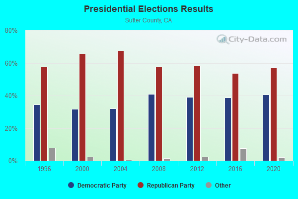
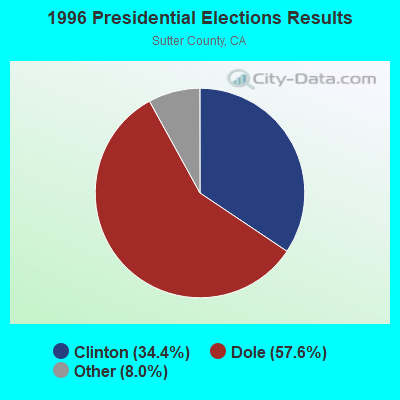
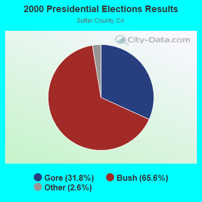
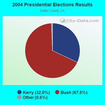
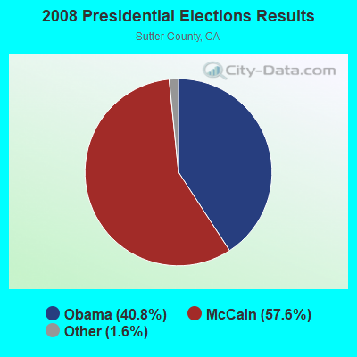
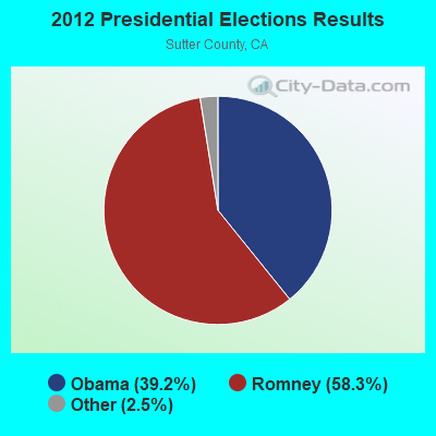
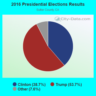
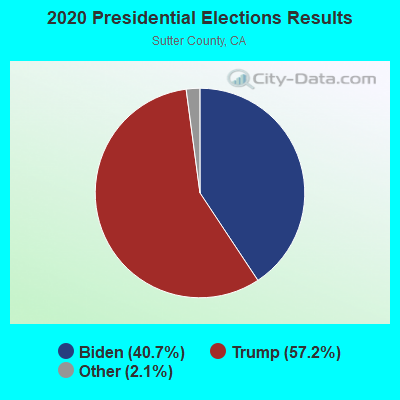
Graphs represent county-level data. Detailed 2008 Election Results
Religion statistics for South Sutter, CA (based on Sutter County data)
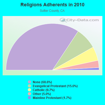
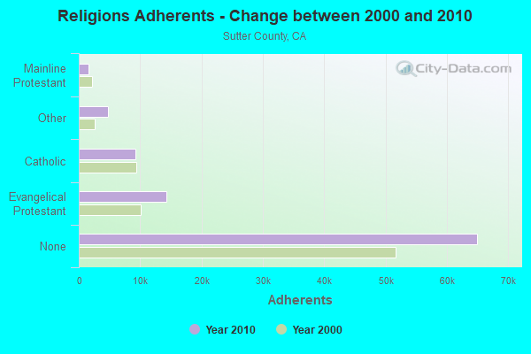
| Religion | Adherents | Congregations |
|---|---|---|
| Evangelical Protestant | 14,212 | 43 |
| Catholic | 9,181 | 3 |
| Other | 4,765 | 17 |
| Mainline Protestant | 1,624 | 7 |
| None | 64,955 | - |
Food Environment Statistics:
| Here: | 2.29 / 10,000 pop. |
| California: | 2.14 / 10,000 pop. |
| This county: | 0.11 / 10,000 pop. |
| State: | 0.04 / 10,000 pop. |
| This county: | 1.42 / 10,000 pop. |
| State: | 0.62 / 10,000 pop. |
| Here: | 2.08 / 10,000 pop. |
| California: | 1.49 / 10,000 pop. |
| Here: | 6.66 / 10,000 pop. |
| California: | 7.42 / 10,000 pop. |
| Sutter County: | 7.4% |
| California: | 7.3% |
| Sutter County: | 24.5% |
| State: | 21.3% |
| This county: | 16.2% |
| California: | 17.9% |
Strongest AM radio stations in South Sutter:
- KFBK (1530 AM; 50 kW; SACRAMENTO, CA; Owner: AMFM RADIO LICENSES, L.L.C.)
- KFIA (710 AM; 25 kW; CARMICHAEL, CA; Owner: VISTA BROADCASTING INC.)
- KSTE (650 AM; 25 kW; RANCHO CORDOVA, CA; Owner: AMFM RADIO LICENSES, L.L.C.)
- KHTK (1140 AM; 50 kW; SACRAMENTO, CA; Owner: INFINITY RADIO SUBSIDIARY OPERATIONS INC.)
- KLIB (1110 AM; 10 kW; ROSEVILLE, CA; Owner: WAY BROADCASTING, INC.)
- KFSG (1690 AM; 10 kW; ROSEVILLE, CA; Owner: WAY BROADCASTING, INC.)
- KAHI (950 AM; 10 kW; AUBURN, CA; Owner: IHR EDUCATIONAL BROADCASTING)
- KSMH (1620 AM; 10 kW; WEST SACRAMENTO, CA; Owner: IHR EDUCATIONAL BROADCASTING)
- KMYC (1410 AM; 5 kW; MARYSVILLE, CA; Owner: THOMAS F. HUTH)
- KUBA (1600 AM; 5 kW; YUBA CITY, CA; Owner: HARLAN COMMUNICATIONS, INC.)
- KCTC (1320 AM; 5 kW; SACRAMENTO, CA; Owner: ENTERCOM SACRAMENTO LICENSE, LLC)
- KCBS (740 AM; 50 kW; SAN FRANCISCO, CA; Owner: INFINITY BROADCASTING OPERATIONS, INC.)
- KCBC (770 AM; 50 kW; RIVERBANK, CA; Owner: KIERTRON, INC.)
Strongest FM radio stations in South Sutter:
- KXCL (103.9 FM; YUBA CITY, CA; Owner: HARLAN COMMUNICATIONS, INC.)
- KRCX-FM (99.9 FM; MARYSVILLE, CA; Owner: ENTRAVISION HOLDINGS, LLC)
- KMJE (101.5 FM; GRIDLEY, CA; Owner: RESULTS RADIO LICENSEE, LLC)
- K213BZ (90.5 FM; RICHVALE, CA; Owner: FAMILY STATIONS, INC.)
- KKCY (103.1 FM; COLUSA, CA; Owner: RESULTS RADIO LICENSEE, LLC)
- KXPR (90.9 FM; SACRAMENTO, CA; Owner: CALIFORNIA STATE UNIVERSITY)
- KGBY (92.5 FM; SACRAMENTO, CA; Owner: AMFM RADIO LICENSES, L.L.C.)
- KDND (107.9 FM; SACRAMENTO, CA; Owner: ENTERCOM SACRAMENTO LICENSE, LLC)
- KNDL (89.9 FM; ANGWIN, CA; Owner: HOWELL MOUNTAIN BROADCASTING COMPANY)
- KLVR (91.9 FM; SANTA ROSA, CA; Owner: EDUCATIONAL MEDIA FOUNDATION)
- KUIC (95.3 FM; VACAVILLE, CA; Owner: KUIC, INC.)
- KXTS (100.9 FM; CALISTOGA, CA; Owner: SINCLAIR TELECABLE, INC.)
- KQEI-FM (89.3 FM; NORTH HIGHLANDS, CA; Owner: KQED, INC.)
- KBBF (89.1 FM; SANTA ROSA, CA; Owner: BILINGUAL B/CING. FOUNDATION, INC.)
- KSEG (96.9 FM; SACRAMENTO, CA; Owner: ENTERCOM SACRAMENTO LICENSE, LLC)
- KKSF-FM1 (103.7 FM; PLEASANTON, ETC., CA; Owner: AMFM RADIO LICENSES, L.L.C.)
- K284AG (104.7 FM; WOODLAND, CA; Owner: EDUCATIONAL MEDIA FOUNDATION)
- KYMX (96.1 FM; SACRAMENTO, CA; Owner: INFINITY RADIO OPERATIONS INC.)
- KBLX-FM2 (102.9 FM; PLEASANTON, CA; Owner: ICBC BROADCAST HOLDINGS -CA, INC.)
- KSOL-FM3 (98.9 FM; PLEASANTON, CA; Owner: TMS LICENSE CALIFORNIA, INC)
TV broadcast stations around South Sutter:
- KEZT-CA (Channel 23; SACRAMENTO, CA; Owner: TELEFUTURA SACRAMENTO LLC)
- KMMK-LP (Channel 14; SACRAMENTO, CA; Owner: CABALLERO TELEVISION TEXAS, L.L.C.)
- K17EH (Channel 17; EUREKA, CA; Owner: MS COMMUNICATIONS, LLC)
- KSAO-LP (Channel 49; SACRAMENTO, CA; Owner: GARY M. COCOLA FAMILY TRUST, GARY M. COCOLA TRUSTEE)
- KBTV-LP (Channel 8; SACRAMENTO, CA; Owner: INCISOR COMMUNICATIONS, L.L.C.)
- KMUM-CA (Channel 15; SACRAMENTO, CA; Owner: CABALLERO TELEVISION TEXAS, L.L.C.)
- KSPX (Channel 29; SACRAMENTO, CA; Owner: PAXSON SACRAMENTO LICENSE, INC.)
- KTXL (Channel 40; SACRAMENTO, CA; Owner: CHANNEL 40, INC.)
- KQCA (Channel 58; STOCKTON, CA; Owner: KCRA HEARST-ARGYLE TELEVISION, INC.)
- KCRA-TV (Channel 3; SACRAMENTO, CA; Owner: KCRA HEARST-ARGYLE TELEVISION, INC.)
- KOVR (Channel 13; STOCKTON, CA; Owner: SCI - SACRAMENTO LICENSEE, LLC)
- KXTV (Channel 10; SACRAMENTO, CA; Owner: KXTV, INC.)
- KVIE (Channel 6; SACRAMENTO, CA; Owner: KVIE, INC.)
- K27FX (Channel 27; EUREKA, CA; Owner: MS COMMUNICATIONS, LLC)
- KUVS (Channel 19; MODESTO, CA; Owner: KUVS LICENSE PARTNERSHIP, G.P.)
- KMAX-TV (Channel 31; SACRAMENTO, CA; Owner: UPN STATIONS GROUP INC.)
- K69FB (Channel 69; SACRAMENTO, CA; Owner: TRINITY BROADCASTING NETWORK)
- K22FR (Channel 22; SACRAMENTO, CA; Owner: NATIONAL MINORITY T.V., INC.)
- KCSO-LP (Channel 33; SACRAMENTO, CA; Owner: SAINTE 51, L.P.)
- K27EU (Channel 27; SACRAMENTO, CA; Owner: ABUNDANT LIFE BROADCASTING, INC.)
- KRJR-LP (Channel 47; SACRAMENTO, CA; Owner: WORD OF GOD FELLOWSHIP, INC.)

- 57.3%Bottled, tank, or LP gas
- 19.1%Electricity
- 16.8%Wood
- 2.3%Fuel oil, kerosene, etc.
- 2.2%Utility gas
- 1.0%Other fuel
- 0.9%No fuel used
- 0.4%Coal or coke

- 50.7%Bottled, tank, or LP gas
- 20.2%Wood
- 19.9%Electricity
- 7.0%Utility gas
- 2.2%Other fuel
South Sutter compared to California state average:
- Unemployed percentage below state average.
- Black race population percentage significantly below state average.
- Hispanic race population percentage below state average.
- Median age above state average.
- Foreign-born population percentage significantly below state average.
- Length of stay since moving in significantly above state average.
- Number of rooms per house significantly below state average.
- House age significantly below state average.