Southeastern El Paso, Colorado
Submit your own pictures of this place and show them to the world
- OSM Map
- General Map
- Google Map
- MSN Map

| Males: 6,567 | |
| Females: 6,183 |
| Median resident age: | 31.3 years |
| Colorado median age: | 34.3 years |
Zip code: 80928
| Southeastern El Paso: | $81,562 |
| CO: | $89,302 |
Estimated per capita income in 2022: $30,990 (it was $16,155 in 2000)
Southeastern El Paso CCD income, earnings, and wages data
Estimated median house or condo value in 2022: $425,177 (it was $131,500 in 2000)
| Southeastern El Paso: | $425,177 |
| CO: | $531,100 |
Mean prices in 2022: all housing units: $503,275; detached houses: $535,696; townhouses or other attached units: $381,161; in 2-unit structures: $406,006; in 3-to-4-unit structures: $554,292; in 5-or-more-unit structures: $266,423; mobile homes: $79,761; occupied boats, rvs, vans, etc.: $4,596
Southeastern El Paso, CO residents, houses, and apartments details
Detailed information about poverty and poor residents in Southeastern El Paso, CO
Compare current foreclosures near Southeastern El Paso, CO:
| Photo | Address | Area | Beds / Baths | Price | Details |
|---|---|---|---|---|---|

|
#1
Pipestem Ave
Colorado Springs, CO 80928
|
1,512 sq. feet
|
2 baths 4 beds |
show details | |

|
#2
Hanover Rd
Colorado Springs, CO 80928
|
1,539 sq. feet
|
2 baths 3 beds |
show details | |

|
#3
Wando Dr
Colorado Springs, CO 80925
|
- sq. feet
|
2 baths 4 beds |
show details | |

|
#4
Shining Star Dr
Colorado Springs, CO 80925
|
2,745 sq. feet
|
4 baths 4 beds |
show details | |

|
#5
Sage Crest Rd
Peyton, CO 80831
|
1,782 sq. feet
|
2 baths 4 beds |
show details | |

|
#6
Gunbarrel Dr
Colorado Springs, CO 80925
|
1,628 sq. feet
|
3 baths 3 beds |
show details | |

|
#7
Sahara Dr
Peyton, CO 80831
|
1,038 sq. feet
|
1 baths 3 beds |
show details | |

|
#8
S Yoder Rd
Yoder, CO 80864
|
1,296 sq. feet
|
2 baths 3 beds |
show details | |

|
#9
S Yoder Rd
Yoder, CO 80864
|
- sq. feet
|
2 baths 3 beds |
show details | |

|
#10
Gunbarrel Dr
Colorado Springs, CO 80925
|
1,700 sq. feet
|
2 baths 3 beds |
show details |
| Photo | Address | Area | Beds / Baths | Price | Details |
|---|---|---|---|---|---|

|
#11
Deer Meadow Cir
Colorado Springs, CO 80925
|
1,908 sq. feet
|
2 baths 4 beds |
show details | |

|
#12
Judge Orr Rd
Calhan, CO 80808
|
2,226 sq. feet
|
2 baths 4 beds |
show details | |

|
#13
Diamond E Rd
Fountain, CO 80817
|
1,110 sq. feet
|
1 baths 3 beds |
show details | |

|
#14
John Ross Ct
Peyton, CO 80831
|
1,510 sq. feet
|
2 baths 3 beds |
show details | |

|
#15
Diamond E Rd
Fountain, CO 80817
|
1,110 sq. feet
|
1 baths 3 beds |
show details | |

|
#16
Mulberry Rd
Calhan, CO 80808
|
2,095 sq. feet
|
2 baths 3 beds |
show details | |

|
#17
Rio Rd
Peyton, CO 80831
|
1,890 sq. feet
|
2 baths 3 beds |
show details | |

|
#18
Double D Rd
Fountain, CO 80817
|
1,676 sq. feet
|
2 baths 3 beds |
show details | |

|
#19
Deer Trl
Colorado Springs, CO 80911
|
1,732 sq. feet
|
1 baths 2 beds |
show details | |

|
#20
Mccandlish Rd
Peyton, CO 80831
|
1,120 sq. feet
|
2 baths 3 beds |
show details |
| Photo | Address | Area | Beds / Baths | Price | Details |
|---|---|---|---|---|---|

|
#21
Sand Pl
Peyton, CO 80831
|
1,620 sq. feet
|
2 baths 3 beds |
show details | |

|
#22
Willowick Ct
Colorado Springs, CO 80925
|
3,096 sq. feet
|
3 baths 5 beds |
show details | |

|
#23
Coral Ridge Dr
Colorado Springs, CO 80925
|
2,530 sq. feet
|
3 baths 4 beds |
show details | |

|
#24
Falling Star Rd
Fountain, CO 80817
|
2,238 sq. feet
|
2 baths 2 beds |
show details | |

|
#25
Candelabra Dr
Colorado Springs, CO 80925
|
2,425 sq. feet
|
3 baths 5 beds |
show details | |

|
#26
Brook Forest Dr
Colorado Springs, CO 80911
|
1,208 sq. feet
|
2 baths 3 beds |
show details | |

|
#27
Finch Rd
Colorado Springs, CO 80928
|
2,591 sq. feet
|
3 baths 5 beds |
show details | |

|
#28
S Yoder Rd
Yoder, CO 80864
|
1,296 sq. feet
|
2 baths 3 beds |
show details | |

|
#29
Big Springs Rd
Yoder, CO 80864
|
2,142 sq. feet
|
2 baths 3 beds |
show details | |

|
#30
Edison Rd
Yoder, CO 80864
|
2,027 sq. feet
|
3 baths 5 beds |
show details |
| Photo | Address | Area | Beds / Baths | Price | Details |
|---|---|---|---|---|---|

|
#31
Edison Rd
Yoder, CO 80864
|
2,027 sq. feet
|
3 baths 5 beds |
show details | |

|
#32
Storybook Ln
Colorado Springs, CO 80928
|
1,976 sq. feet
|
3 baths 4 beds |
show details | |

|
#33
Darroll Rd
Yoder, CO 80864
|
1,802 sq. feet
|
2 baths 4 beds |
show details | |

|
#34
Wagon Train Loop
Peyton, CO 80831
|
2,128 sq. feet
|
2 baths 4 beds |
show details | |

|
#35
S Peyton Hwy
Colorado Springs, CO 80928
|
2,052 sq. feet
|
2 baths 4 beds |
show details | |

|
#36
Oasis Ave
Peyton, CO 80831
|
2,126 sq. feet
|
2 baths 4 beds |
show details | |

|
#37
Sanborn Rd
Calhan, CO 80808
|
1,809 sq. feet
|
2 baths 4 beds |
show details | |

|
#38
Awesome Vw
Yoder, CO 80864
|
1,736 sq. feet
|
2 baths 3 beds |
show details | |

|
#39
Desert Lily Cir
Colorado Springs, CO 80925
|
- sq. feet
|
- baths - beds |
show details | |

|
#40
Sage Crest Road
Colorado Springs, CO Array
|
- sq. feet
|
- baths - beds |
show details |
| Photo | Address | Area | Beds / Baths | Price | Details |
|---|---|---|---|---|---|

|
#41
Flying Hawk Vw # 43
Calhan, CO 80808
|
- sq. feet
|
- baths - beds |
show details | |

|
#42
Chia Dr
Colorado Springs, CO 80925
|
- sq. feet
|
- baths - beds |
show details | |

|
#43
Meadow Brook Dr
Colorado Springs, CO 80928
|
- sq. feet
|
- baths - beds |
show details | |

|
#44
Alpine Daisy Dr
Colorado Springs, CO 80925
|
- sq. feet
|
- baths - beds |
show details | |

|
#45
Sunny View Ln
Colorado Springs, CO 80911
|
- sq. feet
|
- baths - beds |
show details | |

|
#46
Big Johnson Dr
Colorado Springs, CO 80925
|
- sq. feet
|
- baths - beds |
show details | |

|
#47
Campground Dr
Fountain, CO 80817
|
- sq. feet
|
- baths - beds |
show details | |

|
#48
Truckton Rd
Rush, CO 80833
|
- sq. feet
|
- baths - beds |
show details | |

|
#49
S Yoder Rd
Colorado Springs, CO Array
|
- sq. feet
|
- baths - beds |
show details | |

|
Check over 1 million property listings on Foreclosure.com!
|
browse all offers | |||

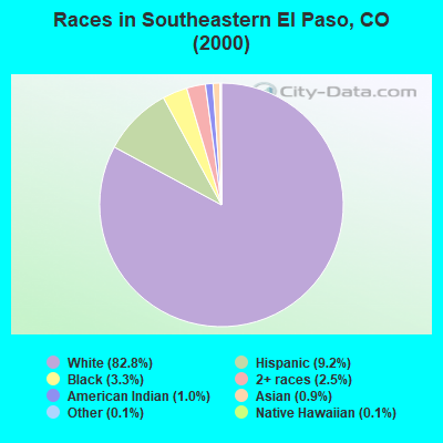
- 9,37082.8%White alone
- 1,0399.2%Hispanic
- 3773.3%Black alone
- 2782.5%Two or more races
- 1131.0%American Indian alone
- 1060.9%Asian alone
- 130.1%Native Hawaiian and Other
Pacific Islander alone - 160.1%Other race alone
 Recent articles from our blog. Our writers, many of them Ph.D. graduates or candidates, create easy-to-read articles on a wide variety of topics.

Current Local Time: MST time zone
Land area: 906.1 square miles.
Population density: 14 people per square mile (very low).

| Southeastern El Paso CCD: | 0.6% ($731) |
| Colorado: | 0.7% ($1,132) |
Nearest city with pop. 50,000+: Colorado Springs, CO  (23.8 miles , pop. 360,890).
Nearest city with pop. 1,000,000+: Phoenix, AZ (561.4 miles , pop. 1,321,045).
Nearest cities:
), ), ), ), )Latitude: 38.75 N, Longitude: 104.37 W
Area code commonly used in this area: 719

| Here: | 3.3% |
| Colorado: | 3.2% |
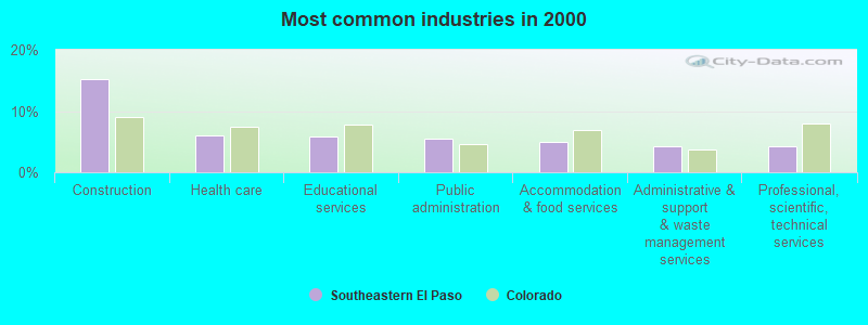
- Construction (15.3%)
- Health care (6.1%)
- Educational services (5.8%)
- Public administration (5.5%)
- Accommodation & food services (4.9%)
- Administrative & support & waste management services (4.2%)
- Professional, scientific, technical services (4.2%)
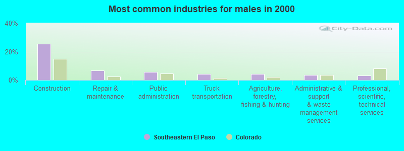
- Construction (25.6%)
- Repair & maintenance (6.6%)
- Public administration (5.6%)
- Truck transportation (4.4%)
- Agriculture, forestry, fishing & hunting (4.3%)
- Administrative & support & waste management services (3.5%)
- Professional, scientific, technical services (3.1%)
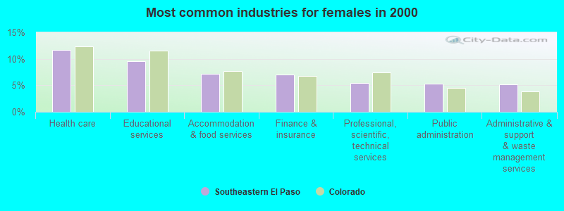
- Health care (11.6%)
- Educational services (9.5%)
- Accommodation & food services (7.2%)
- Finance & insurance (7.0%)
- Professional, scientific, technical services (5.5%)
- Public administration (5.3%)
- Administrative & support & waste management services (5.1%)
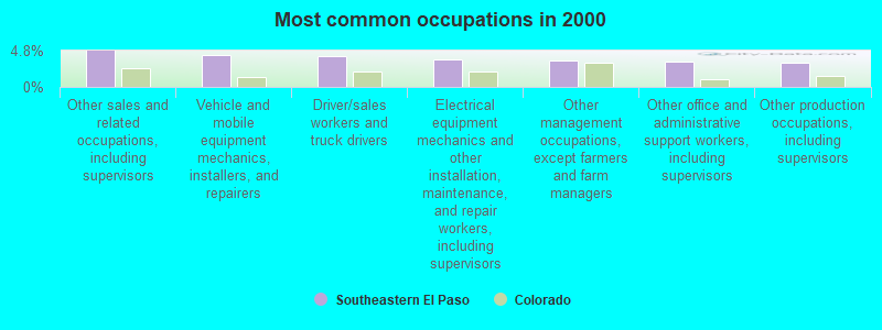
- Other sales and related occupations, including supervisors (4.8%)
- Vehicle and mobile equipment mechanics, installers, and repairers (4.2%)
- Driver/sales workers and truck drivers (4.1%)
- Electrical equipment mechanics and other installation, maintenance, and repair workers, including supervisors (3.7%)
- Other management occupations, except farmers and farm managers (3.5%)
- Other office and administrative support workers, including supervisors (3.3%)
- Other production occupations, including supervisors (3.3%)
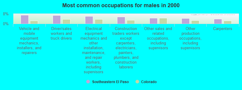
- Vehicle and mobile equipment mechanics, installers, and repairers (7.1%)
- Driver/sales workers and truck drivers (6.8%)
- Electrical equipment mechanics and other installation, maintenance, and repair workers, including supervisors (6.1%)
- Construction traders workers except carpenters, electricians, painters, plumbers, and construction laborers (5.5%)
- Other sales and related occupations, including supervisors (4.5%)
- Other production occupations, including supervisors (4.4%)
- Carpenters (4.0%)
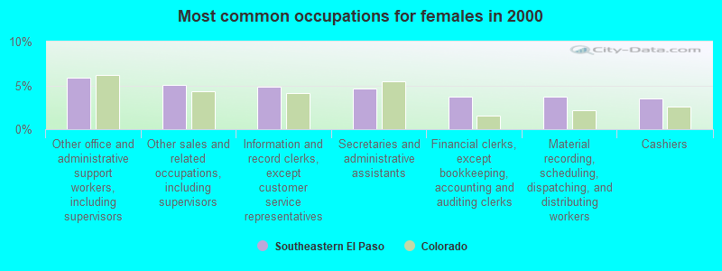
- Other office and administrative support workers, including supervisors (5.9%)
- Other sales and related occupations, including supervisors (5.1%)
- Information and record clerks, except customer service representatives (4.9%)
- Secretaries and administrative assistants (4.6%)
- Financial clerks, except bookkeeping, accounting and auditing clerks (3.7%)
- Material recording, scheduling, dispatching, and distributing workers (3.7%)
- Cashiers (3.5%)
Average climate in Southeastern El Paso, Colorado
Based on data reported by over 4,000 weather stations


(lower is better)
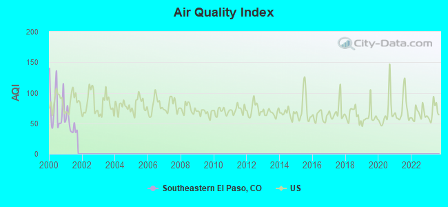
Air Quality Index (AQI) level in 2001 was 47.7. This is significantly better than average.
| City: | 47.7 |
| U.S.: | 72.6 |
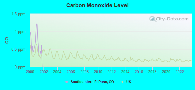
Carbon Monoxide (CO) [ppm] level in 2001 was 0.574. This is significantly worse than average. Closest monitor was 19.4 miles away from the city center.
| City: | 0.574 |
| U.S.: | 0.251 |
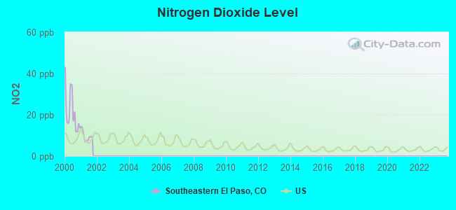
Nitrogen Dioxide (NO2) [ppb] level in 2001 was 9.69. This is significantly worse than average. Closest monitor was 19.4 miles away from the city center.
| City: | 9.69 |
| U.S.: | 5.11 |
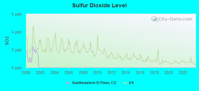
Sulfur Dioxide (SO2) [ppb] level in 2001 was 1.76. This is about average. Closest monitor was 18.9 miles away from the city center.
| City: | 1.76 |
| U.S.: | 1.51 |
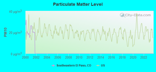
Particulate Matter (PM10) [µg/m3] level in 2001 was 22.1. This is about average. Closest monitor was 19.4 miles away from the city center.
| City: | 22.1 |
| U.S.: | 19.2 |
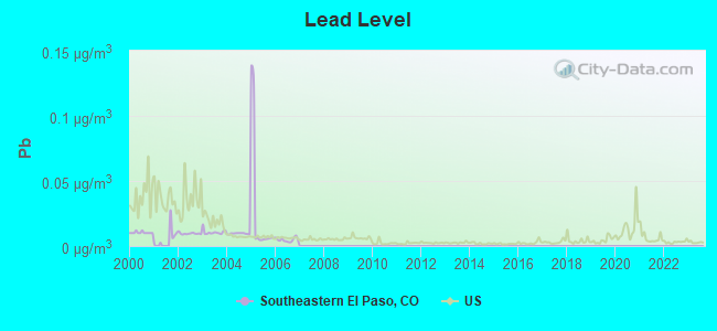
Lead (Pb) [µg/m3] level in 2006 was 0.00479. This is significantly better than average. Closest monitor was 23.7 miles away from the city center.
| City: | 0.00479 |
| U.S.: | 0.00931 |
Tornado activity:
Southeastern El Paso-area historical tornado activity is slightly above Colorado state average. It is 21% smaller than the overall U.S. average.
On 6/24/1979, a category F3 (max. wind speeds 158-206 mph) tornado 25.1 miles away from the Southeastern El Paso place center injured one person and caused between $50,000 and $500,000 in damages.
On 6/13/1977, a category F3 tornado 31.6 miles away from the place center .
Earthquake activity:
Southeastern El Paso-area historical earthquake activity is significantly above Colorado state average. It is 682% greater than the overall U.S. average.On 8/18/1959 at 06:37:13, a magnitude 7.7 (7.7 UK, Class: Major, Intensity: VIII - XII) earthquake occurred 516.4 miles away from Southeastern El Paso center, causing $26,000,000 total damage
On 8/23/2011 at 05:46:18, a magnitude 5.3 (5.3 MW, Depth: 2.5 mi, Class: Moderate, Intensity: VI - VII) earthquake occurred 118.2 miles away from the city center
On 8/10/2005 at 22:08:22, a magnitude 5.0 (5.0 MW, Depth: 3.1 mi) earthquake occurred 127.3 miles away from the city center
On 8/10/2005 at 22:08:22, a magnitude 5.0 (5.0 MB, 4.7 MS, 5.0 MW) earthquake occurred 128.5 miles away from Southeastern El Paso center
On 10/18/1984 at 15:30:23, a magnitude 5.5 (5.4 MB, 5.1 MS, 5.5 ML) earthquake occurred 259.7 miles away from Southeastern El Paso center
On 8/22/2011 at 23:30:19, a magnitude 4.7 (4.7 MW, Depth: 3.1 mi, Class: Light, Intensity: IV - V) earthquake occurred 119.4 miles away from Southeastern El Paso center
Magnitude types: body-wave magnitude (MB), local magnitude (ML), surface-wave magnitude (MS), moment magnitude (MW)
Natural disasters:
The number of natural disasters in El Paso County (17) is near the US average (15).Major Disasters (Presidential) Declared: 10
Emergencies Declared: 5
Causes of natural disasters: Floods: 7, Storms: 7, Fires: 4, Landslides: 4, Mudslides: 4, Snows: 2, Tornadoes: 2, Drought: 1, Flash Flood: 1, Heavy Rain: 1, Hurricane: 1, Snowstorm: 1, Other: 1 (Note: some incidents may be assigned to more than one category).
Colleges/universities with over 2000 students nearest to Southeastern El Paso:
- Pikes Peak Community College (about 23 miles; Colorado Springs, CO; Full-time enrollment: 10,395)
- University of Colorado Colorado Springs (about 25 miles; Colorado Springs, CO; FT enrollment: 8,700)
- Colorado College (about 26 miles; Colorado Springs, CO; FT enrollment: 2,199)
- Colorado Technical University-Colorado Springs (about 27 miles; Colorado Springs, CO; FT enrollment: 2,049)
- Colorado Technical University-Online (about 27 miles; Colorado Springs, CO; FT enrollment: 22,771)
- Colorado State University-Pueblo (about 33 miles; Pueblo, CO; FT enrollment: 5,993)
- United States Air Force Academy (about 34 miles; USAFA, CO; FT enrollment: 5,088)
Points of interest:
Notable locations in Southeastern El Paso: Novak Ranch (A), Murr Ranch (B), Garrett Ranch (C), Fulsos Ranch (D), Big Springs Ranch (E), Alger Ranch (F), Book Ranch (G), Hammer Ranch (H), Benedict Ranch (I), Polo Ranch (J), Guitman Ranch (K), Dentan Ranch (L), Gieck Ranch (M), Slocum Ranch (N), Davis Ranch (O), Balser Ranch (P), Boucher Ranch (Q), Haegler Ranch (R), Hook and Line Ranch (S), Solberg Ranch (T). Display/hide their locations on the map
Churches in Southeastern El Paso include: Llader Church (A), Hanover Church (B). Display/hide their locations on the map
Cemeteries: Saint Lukes Cemetery (1), Antioch Cemetery (2), Leader Church Cemetery (3), Lone Memorial (4), Chico Basin Cemetery (5), Crescent Cemetery (6). Display/hide their locations on the map
Reservoirs: Banning Lewis Reservoir Number 8 (A), Charles Golding Reservoir (B), Curiton Reservoir (C), Youngs Puddle (D). Display/hide their locations on the map
Creeks: Brackett Creek (A), Big Springs Creek (B). Display/hide their locations on the map
| This place: | 2.8 people |
| Colorado: | 2.5 people |
| This place: | 78.2% |
| Whole state: | 63.9% |
| This place: | 5.3% |
| Whole state: | 6.5% |
Likely homosexual households (counted as self-reported same-sex unmarried-partner households)
- Lesbian couples: 0.4% of all households
- Gay men: 0.3% of all households
| This place: | 10.1% |
| Whole state: | 9.3% |
| This place: | 4.2% |
| Whole state: | 4.1% |
5 people in other group homes in 2000
For population 15 years and over in Southeastern El Paso:
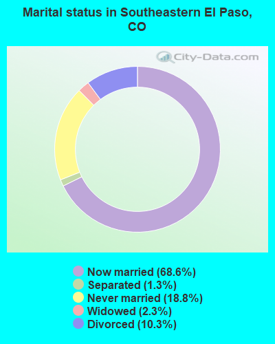
- Never married: 18.8%
- Now married: 68.6%
- Separated: 1.3%
- Widowed: 2.3%
- Divorced: 10.3%
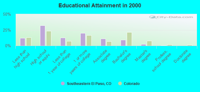
For population 25 years and over in Southeastern El Paso:
- High school or higher: 88.0%
- Bachelor's degree or higher: 12.4%
- Graduate or professional degree: 3.0%
- Unemployed: 4.9%
- Mean travel time to work (commute): 36.4 minutes
| Here: | 8.7 |
| Colorado average: | 11.8 |
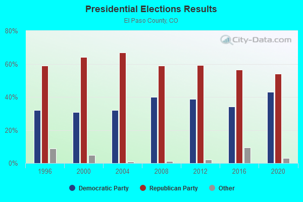
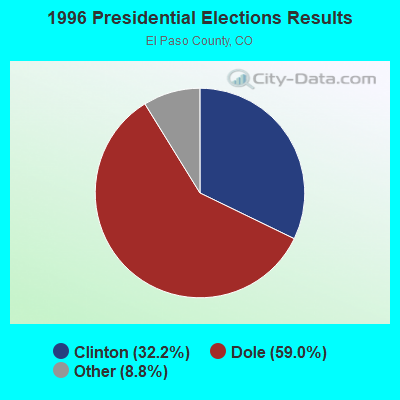
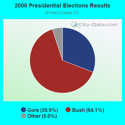
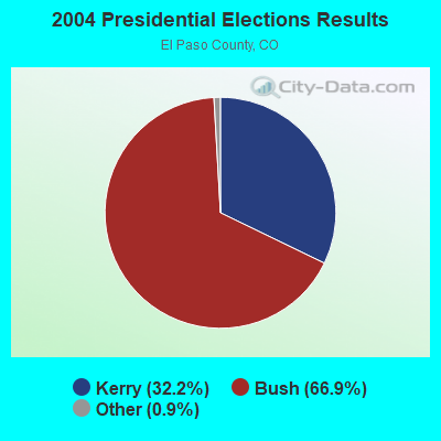
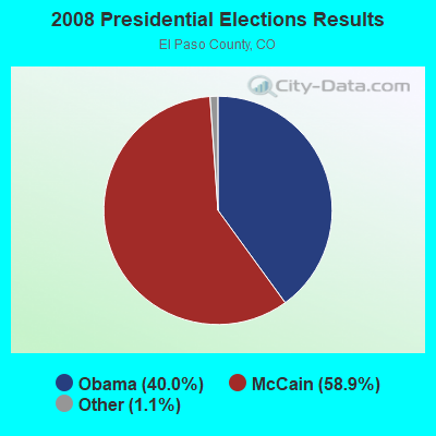
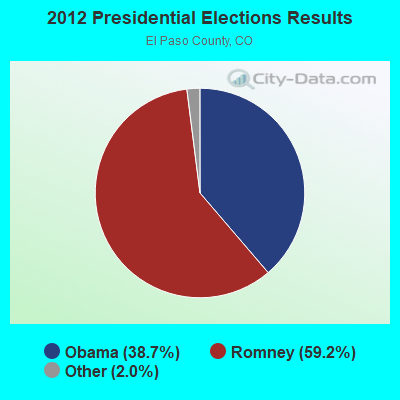
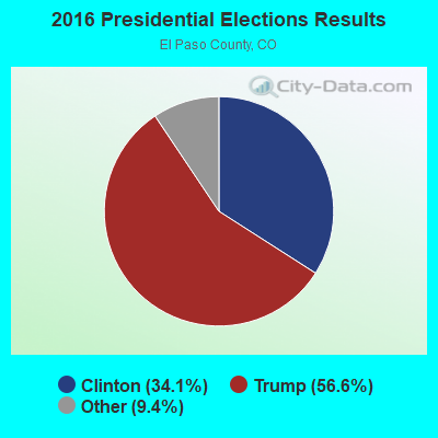
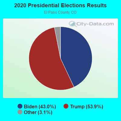
Graphs represent county-level data. Detailed 2008 Election Results
Religion statistics for Southeastern El Paso, CO (based on El Paso County data)
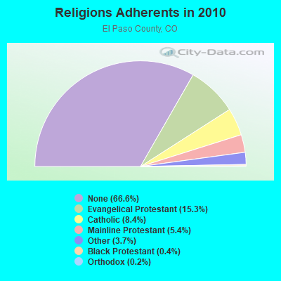
| Religion | Adherents | Congregations |
|---|---|---|
| Evangelical Protestant | 95,284 | 265 |
| Catholic | 52,310 | 23 |
| Mainline Protestant | 33,697 | 61 |
| Other | 22,775 | 62 |
| Black Protestant | 2,686 | 11 |
| Orthodox | 947 | 4 |
| None | 414,564 | - |
Food Environment Statistics:
| This county: | 0.97 / 10,000 pop. |
| Colorado: | 1.50 / 10,000 pop. |
| El Paso County: | 0.15 / 10,000 pop. |
| State: | 0.15 / 10,000 pop. |
| This county: | 0.34 / 10,000 pop. |
| State: | 0.45 / 10,000 pop. |
| This county: | 2.87 / 10,000 pop. |
| State: | 3.13 / 10,000 pop. |
| El Paso County: | 6.64 / 10,000 pop. |
| Colorado: | 8.99 / 10,000 pop. |
| Here: | 5.5% |
| State: | 5.3% |
| This county: | 19.8% |
| Colorado: | 18.4% |
| This county: | 7.0% |
| Colorado: | 9.6% |
9.81% of this county's 2021 resident taxpayers lived in other counties in 2020 ($64,463 average adjusted gross income)
| Here: | 9.81% |
| Colorado average: | 11.28% |
0.28% of residents moved from foreign countries ($1,844 average AGI)
El Paso County: 0.28% Colorado average: 0.05%
Top counties from which taxpayers relocated into this county between 2020 and 2021:
| from Arapahoe County, CO | |
| from Douglas County, CO | |
| from Denver County, CO |
9.66% of this county's 2020 resident taxpayers moved to other counties in 2021 ($62,154 average adjusted gross income)
| Here: | 9.66% |
| Colorado average: | 11.05% |
0.19% of residents moved to foreign countries ($1,409 average AGI)
El Paso County: 0.19% Colorado average: 0.03%
Top counties to which taxpayers relocated from this county between 2020 and 2021:
| to Pueblo County, CO | |
| to Denver County, CO | |
| to Douglas County, CO |
Strongest AM radio stations in Southeastern El Paso:
- KCBR (1040 AM; daytime; 15 kW; MONUMENT, CO; Owner: KLZ RADIO, INC.)
- KCMN (1530 AM; 15 kW; COLORADO SPRINGS, CO)
- KWYD (1580 AM; 10 kW; COLORADO SPRINGS, CO; Owner: PILGRIM COMMUNICATIONS, INC.)
- KOA (850 AM; 50 kW; DENVER, CO; Owner: JACOR BROADCASTING OF COLORADO, INC.)
- KMXA (1090 AM; 50 kW; AURORA, CO; Owner: ENTRAVISION HOLDINGS, LLC)
- KLTT (670 AM; 50 kW; COMMERCE CITY, CO; Owner: KLZ RADIO, INC.)
- KKCS (1460 AM; 5 kW; COLORADO SPRINGS, CO; Owner: WALTON STATIONS - COLORADO, INC.)
- KKZN (760 AM; 50 kW; THORNTON, CO; Owner: JACOR BROADCASTING OF COLORADO, INC.)
- KBZC (1300 AM; 5 kW; COLORADO SPRINGS, CO; Owner: CITADEL BROADCASTING COMPANY)
- KVOR (740 AM; 3 kW; COLORADO SPRINGS, CO; Owner: CITADEL BROADCASTING COMPANY)
- KCUV (1510 AM; 25 kW; LITTLETON, CO; Owner: PEOPLE WIRELESS, INC.)
- KGHF (1350 AM; 5 kW; PUEBLO, CO; Owner: CLEAR CHANNEL BROADCASTING LICENSES, INC.)
- KLMO (1060 AM; 30 kW; LONGMONT, CO; Owner: PILGRIM COMMUNICATIONS, INC.)
Strongest FM radio stations in Southeastern El Paso:
- KCCY (96.9 FM; PUEBLO, CO; Owner: CAPSTAR TX LIMITED PARTNERSHIP)
- KKMG (98.9 FM; PUEBLO, CO; Owner: CITADEL BROADCASTING COMPANY)
- KYZX (103.9 FM; PUEBLO WEST, CO; Owner: COLORADO SPRINGS RADIO B/CASTRS, INC)
- KKFM (98.1 FM; COLORADO SPRINGS, CO; Owner: CITADEL BROADCASTING COMPANY)
- KBIQ (102.7 FM; MANITOU SPRINGS, CO; Owner: BISON MEDIA, INC.)
- KKCS-FM (101.9 FM; COLORADO SPRINGS, CO; Owner: WALTON STATIONS - COLORADO, INC.)
- KRCC (91.5 FM; COLORADO SPRINGS, CO; Owner: THE COLORADO COLLEGE)
- KSKX (105.5 FM; SECURITY, CO; Owner: OPTIMA COMMUNICATIONS, INC.)
- KGFT (100.7 FM; PUEBLO, CO; Owner: BISON MEDIA, INC)
- KKLI (106.3 FM; WIDEFIELD, CO; Owner: CAPSTAR TX LIMITED PARTNERSHIP)
- KTLF (90.5 FM; COLORADO SPRINGS, CO; Owner: EDUCATIONAL COMMUNICATIONS OF COLORADO SPRINGS, INC.)
- KMOM (96.1 FM; FOUNTAIN, CO; Owner: AMFM TEXAS LICENSES LIMITED PARTNERSHIP)
- KSPZ (92.9 FM; COLORADO SPRINGS, CO; Owner: CITADEL BROADCASTING COMPANY)
- KVUU (99.9 FM; PUEBLO, CO; Owner: CAPSTAR TX LIMITED PARTNERSHIP)
- KCME (88.7 FM; MANITOU SPRINGS, CO; Owner: CHEYENNE MOUNTAIN PUBLIC BROADCAST HOUSE, INC)
- KILO (94.3 FM; COLORADO SPRINGS, CO; Owner: COLORADO SPRINGS RADIO BCSTERS, INC.)
- KRDO-FM (95.1 FM; COLORADO SPRINGS, CO; Owner: THE PIKES PEAK BROADCASTING CO.)
- KEPC (89.7 FM; COLORADO SPRINGS, CO; Owner: PIKES PEAK COMMUNITY COLLEGE)
- KAVD (103.1 FM; LIMON, CO; Owner: THE MEADOWLARK GROUP, INC.)
- KJMN (92.1 FM; CASTLE ROCK, CO; Owner: ENTRAVISION HOLDINGS, LLC)
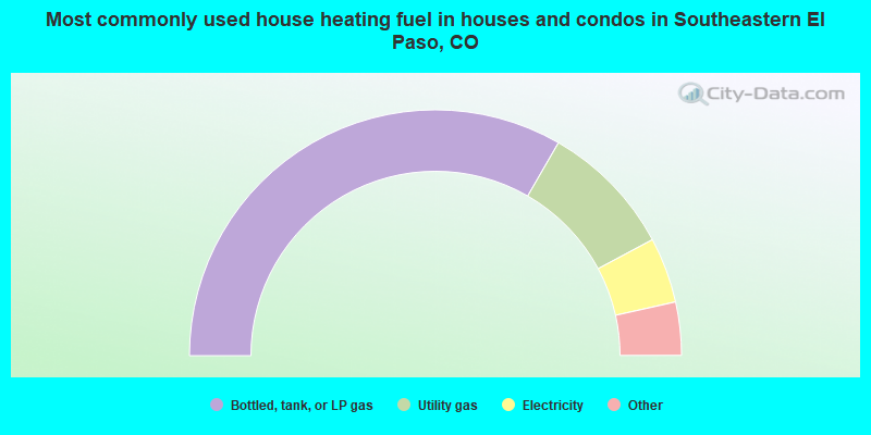
- 66.6%Bottled, tank, or LP gas
- 17.7%Utility gas
- 8.6%Electricity
- 3.9%Wood
- 1.8%Other fuel
- 0.6%Fuel oil, kerosene, etc.
- 0.3%No fuel used
- 0.2%Coal or coke
- 0.1%Solar energy
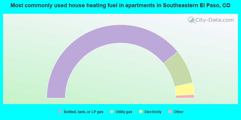
- 78.3%Bottled, tank, or LP gas
- 15.0%Utility gas
- 5.2%Electricity
- 1.0%Wood
- 0.5%No fuel used
Southeastern El Paso compared to Colorado state average:
- Unemployed percentage below state average.
- Hispanic race population percentage below state average.
- Median age below state average.
- Foreign-born population percentage significantly below state average.
- Renting percentage below state average.
- Length of stay since moving in significantly above state average.
- Number of rooms per house significantly below state average.
- House age significantly below state average.
- Percentage of population with a bachelor's degree or higher significantly below state average.
Southeastern El Paso on our top lists:
- #14 on the list of "Top 101 cities with largest percentage of females in industries: electronic shopping and mail-order houses (population 5,000+)"
- #17 on the list of "Top 101 cities with largest percentage of males in industries: repair and maintenance (population 5,000+)"
- #26 on the list of "Top 101 cities with largest percentage of males in occupations: pipelayers, plumbers, pipefitters, and steamfitters (population 5,000+)"
- #41 on the list of "Top 101 cities with largest percentage of males in occupations: vehicle and mobile equipment mechanics, installers, and repairers (population 5,000+)"
- #47 on the list of "Top 101 cities with largest percentage of females in occupations: communications equipment operators (population 5,000+)"
- #48 on the list of "Top 101 cities with largest percentage of females in occupations: financial clerks except bookkeeping, accounting, and auditing clerks (population 5,000+)"
- #48 on the list of "Top 101 cities with largest percentage of females in occupations: vehicle and mobile equipment mechanics, installers, and repairers (population 5,000+)"
- #51 on the list of "Top 101 cities with largest percentage of females in occupations: other protective service workers including supervisors (population 5,000+)"
- #55 on the list of "Top 100 highest located cities"
- #56 on the list of "Top 100 cities with largest land areas (pop. 5,000+)"
- #58 on the list of "Top 101 cities with largest percentage of females in industries: vending machine operators (population 5,000+)"
- #70 on the list of "Top 101 cities with the most cars per house, population 5,000+"
- #73 on the list of "Top 101 cities with largest percentage of females in industries: farm supplies merchant wholesalers (population 5,000+)"
- #82 on the list of "Top 101 cities with largest percentage of females in industries: printing and related support activities (population 5,000+)"
- #92 on the list of "Top 101 cities with largest percentage of females in industries: department and other general merchandise stores (population 5,000+)"
- #97 on the list of "Top 101 cities with largest percentage of males in industries: hardware, plumbing and heating equipment, and supplies merchant wholesalers (population 5,000+)"
- #30 on the list of "Top 101 counties with the highest percentage of residents relocating from foreign countries between 2010 and 2011 (pop. 50,000+)"
- #32 on the list of "Top 101 counties with the lowest average weight of females"
- #39 on the list of "Top 101 counties with the highest percentage of residents that exercised in the past month"
- #42 on the list of "Top 101 counties with the highest percentage of residents relocating to foreign countries in 2011 (pop. 50,000+)"
- #43 on the list of "Top 101 counties with the highest Particulate Matter (PM10) Annual air pollution readings in 2012 (µg/m3)"