Southwest Pontotoc, Oklahoma
Submit your own pictures of this place and show them to the world
- OSM Map
- General Map
- Google Map
- MSN Map

| Males: 709 | |
| Females: 764 |
| Median resident age: | 36.6 years |
| Oklahoma median age: | 35.5 years |
Zip code: 74865
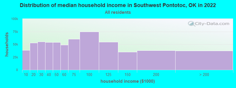
| Southwest Pontotoc: | $54,966 |
| OK: | $59,673 |
Estimated per capita income in 2022: $26,511 (it was $12,901 in 2000)
Southwest Pontotoc CCD income, earnings, and wages data
Estimated median house or condo value in 2022: $104,935 (it was $36,100 in 2000)
| Southwest Pontotoc: | $104,935 |
| OK: | $191,700 |
Mean prices in 2022: all housing units: $207,584; detached houses: $218,520; townhouses or other attached units: $155,914; mobile homes: $86,598; occupied boats, rvs, vans, etc.: $5,420
Southwest Pontotoc, OK residents, houses, and apartments details
Detailed information about poverty and poor residents in Southwest Pontotoc, OK
Compare current foreclosures near Southwest Pontotoc, OK:
| Photo | Address | Area | Beds / Baths | Price | Details |
|---|---|---|---|---|---|

|
#1
Governor Harris Dr
Ada, OK 74820
|
1,592 sq. feet
|
1 baths 3 beds |
$44,900
|
show details |

|
#2
Millennium Jct
Sulphur, OK 73086
|
1,665 sq. feet
|
2 baths 2 beds |
$257,900
|
show details |

|
#3
County Road 3552
Ada, OK 74820
|
1,486 sq. feet
|
1 baths 3 beds |
show details | |

|
#4
S Cherry St
Ada, OK 74820
|
1,080 sq. feet
|
1 baths 2 beds |
show details | |

|
#5
County Road 1528
Ada, OK 74820
|
1,860 sq. feet
|
2 baths 3 beds |
show details | |

|
#6
County Road 3588
Ada, OK 74820
|
1,350 sq. feet
|
1 baths 3 beds |
show details | |

|
#7
Webb Ave
Ada, OK 74820
|
1,509 sq. feet
|
1 baths 3 beds |
show details | |

|
#8
Centennial Blvd
Sulphur, OK 73086
|
1,284 sq. feet
|
2 baths 2 beds |
show details | |

|
#9
Augusta Dr
Ada, OK 74820
|
2,449 sq. feet
|
3 baths 5 beds |
show details | |

|
#10
County Road 1570
Ada, OK 74820
|
2,396 sq. feet
|
2 baths 4 beds |
show details |
| Photo | Address | Area | Beds / Baths | Price | Details |
|---|---|---|---|---|---|

|
#11
W Tishomingo Ave
Sulphur, OK 73086
|
1,698 sq. feet
|
2 baths 3 beds |
show details | |

|
#12
W Wyandotte Ave
Sulphur, OK 73086
|
1,404 sq. feet
|
1 baths 2 beds |
show details | |

|
#13
W 13th St
Sulphur, OK 73086
|
720 sq. feet
|
1 baths 2 beds |
show details | |

|
#14
Whispering Hills St
Ada, OK 74820
|
1,919 sq. feet
|
2 baths 3 beds |
show details | |

|
#15
W 22nd St
Ada, OK 74820
|
1,910 sq. feet
|
1 baths 3 beds |
show details | |

|
#16
W 20th St
Ada, OK 74820
|
1,456 sq. feet
|
1 baths 3 beds |
show details | |

|
#17
S Cherry St
Ada, OK 74820
|
1,179 sq. feet
|
1 baths 2 beds |
show details | |

|
#18
E 1st St
Sulphur, OK 73086
|
1,788 sq. feet
|
2 baths 3 beds |
show details | |

|
#19
E Vinita Ave
Sulphur, OK 73086
|
1,233 sq. feet
|
1 baths 2 beds |
show details | |

|
#20
County Road 1575
Ada, OK 74820
|
1,233 sq. feet
|
1 baths - beds |
show details |
| Photo | Address | Area | Beds / Baths | Price | Details |
|---|---|---|---|---|---|

|
#21
Wolfe Ln
Ada, OK 74820
|
- sq. feet
|
- baths - beds |
show details | |

|
#22
SW Powell 10119 Ct, Cr 3552
Ada, OK 74820
|
- sq. feet
|
- baths - beds |
show details | |

|
#23
S Broadway
Stonewall, OK 74871
|
- sq. feet
|
- baths - beds |
show details | |

|
#24
County Road 1560
Ada, OK 74820
|
- sq. feet
|
- baths - beds |
show details | |

|
#25
N County Road 3370
Stratford, OK 74872
|
- sq. feet
|
- baths - beds |
show details | |

|
#26
County Road 1566
Ada, OK 74820
|
- sq. feet
|
- baths - beds |
show details | |

|
#27
N Us Hwy 377
Connerville, OK 74836
|
- sq. feet
|
- baths - beds |
show details | |

|
#28
County Road 1560
Ada, OK 74820
|
- sq. feet
|
- baths - beds |
show details | |

|
#29
E 1st St
Stratford, OK 74872
|
- sq. feet
|
- baths - beds |
show details | |

|
#30
County Road 3490
Ada, OK 74820
|
- sq. feet
|
- baths - beds |
show details |
| Photo | Address | Area | Beds / Baths | Price | Details |
|---|---|---|---|---|---|

|
#31
Stonebridge
Ada, OK 74820
|
- sq. feet
|
- baths - beds |
show details | |

|
#32
S Hyden
Stratford, OK 74872
|
- sq. feet
|
- baths - beds |
show details | |

|
#33
Williams St
Ada, OK 74820
|
- sq. feet
|
- baths - beds |
show details | |

|
#34
N Cherry St
Ada, OK 74820
|
- sq. feet
|
- baths - beds |
show details | |

|
#35
County Road 1600
Stonewall, OK 74871
|
- sq. feet
|
- baths - beds |
show details | |

|
#36
County Road 3540
Ada, OK 74820
|
- sq. feet
|
- baths - beds |
show details | |

|
#37
E Ardmore Ave
Sulphur, OK 73086
|
- sq. feet
|
- baths - beds |
show details | |

|
#38
W Division
Roff, OK 74865
|
- sq. feet
|
- baths - beds |
show details | |

|
#39
W Wynnewood Ave
Sulphur, OK 73086
|
- sq. feet
|
- baths - beds |
show details | |

|
Check over 1 million property listings on Foreclosure.com!
|
browse all offers | |||

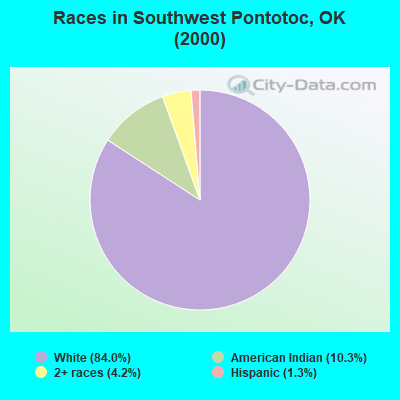
- 1,19684.0%White alone
- 14710.3%American Indian alone
- 604.2%Two or more races
- 191.3%Hispanic
- 10.07%Black alone
Races in Southwest Pontotoc detailed stats: ancestries, foreign born residents, place of birth
 Recent articles from our blog. Our writers, many of them Ph.D. graduates or candidates, create easy-to-read articles on a wide variety of topics.

Current Local Time: CST time zone
Land area: 116.1 square miles.
Population density: 13 people per square mile (very low).

| Southwest Pontotoc CCD: | 0.6% ($199) |
| Oklahoma: | 0.8% ($523) |
Nearest city with pop. 50,000+: Norman, OK  (54.0 miles , pop. 95,694).
Nearest city with pop. 200,000+: Oklahoma City, OK (72.4 miles , pop. 506,132).
Nearest city with pop. 1,000,000+: Dallas, TX (125.8 miles , pop. 1,188,580).
Nearest cities:
), ), ), ), Latitude: 34.62 N, Longitude: 96.81 W
Area code commonly used in this area: 580

| Here: | 3.0% |
| Oklahoma: | 3.2% |
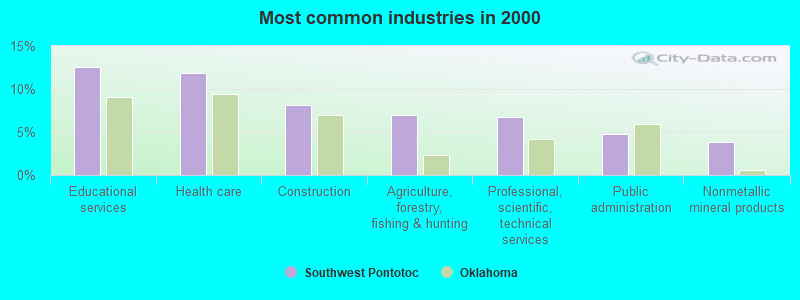
- Educational services (12.6%)
- Health care (11.9%)
- Construction (8.1%)
- Agriculture, forestry, fishing & hunting (6.9%)
- Professional, scientific, technical services (6.8%)
- Public administration (4.8%)
- Nonmetallic mineral products (3.8%)
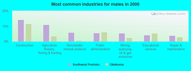
- Construction (14.3%)
- Agriculture, forestry, fishing & hunting (11.0%)
- Nonmetallic mineral products (6.0%)
- Public administration (5.7%)
- Mining, quarrying, oil & gas extraction (5.4%)
- Educational services (4.2%)
- Repair & maintenance (3.9%)
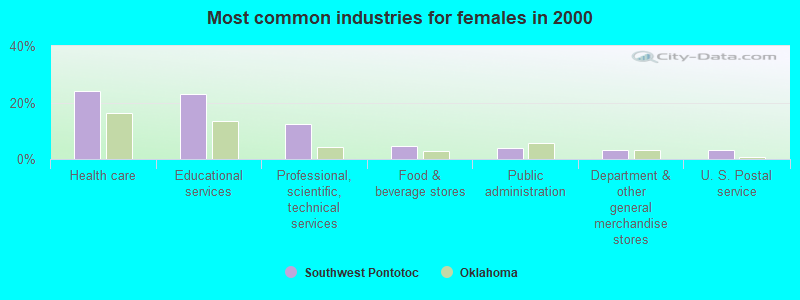
- Health care (24.2%)
- Educational services (23.0%)
- Professional, scientific, technical services (12.3%)
- Food & beverage stores (4.5%)
- Public administration (3.7%)
- Department & other general merchandise stores (3.3%)
- U. S. Postal service (3.3%)
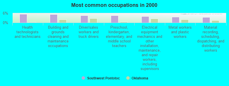
- Health technologists and technicians (5.5%)
- Building and grounds cleaning and maintenance occupations (5.3%)
- Driver/sales workers and truck drivers (4.5%)
- Preschool, kindergarten, elementary, and middle school teachers (4.5%)
- Electrical equipment mechanics and other installation, maintenance, and repair workers, including supervisors (4.0%)
- Metal workers and plastic workers (3.6%)
- Material recording, scheduling, dispatching, and distributing workers (3.5%)
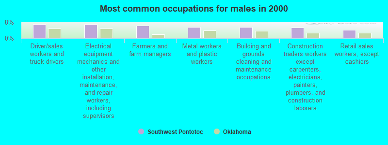
- Driver/sales workers and truck drivers (7.1%)
- Electrical equipment mechanics and other installation, maintenance, and repair workers, including supervisors (7.1%)
- Farmers and farm managers (6.2%)
- Metal workers and plastic workers (5.7%)
- Building and grounds cleaning and maintenance occupations (5.7%)
- Construction traders workers except carpenters, electricians, painters, plumbers, and construction laborers (5.4%)
- Retail sales workers, except cashiers (4.2%)

- Health technologists and technicians (10.8%)
- Preschool, kindergarten, elementary, and middle school teachers (8.2%)
- Accountants and auditors (5.6%)
- Other office and administrative support workers, including supervisors (5.2%)
- Information and record clerks, except customer service representatives (4.8%)
- Building and grounds cleaning and maintenance occupations (4.8%)
- Other teachers, instructors, education, training, and library occupations (4.5%)
Average climate in Southwest Pontotoc, Oklahoma
Based on data reported by over 4,000 weather stations


Tornado activity:
Southwest Pontotoc-area historical tornado activity is slightly above Oklahoma state average. It is 187% greater than the overall U.S. average.
On 5/9/1959, a category F4 (max. wind speeds 207-260 mph) tornado 13.3 miles away from the Southwest Pontotoc place center killed 7 people and injured 12 people and caused between $50,000 and $500,000 in damages.
On 4/19/1972, a category F4 tornado 21.4 miles away from the place center killed 5 people and injured 6 people and caused between $5000 and $50,000 in damages.
Earthquake activity:
Southwest Pontotoc-area historical earthquake activity is significantly above Oklahoma state average. It is 706% greater than the overall U.S. average.On 11/6/2011 at 03:53:10, a magnitude 5.7 (5.7 MW, Depth: 3.2 mi, Class: Moderate, Intensity: VI - VII) earthquake occurred 63.3 miles away from Southwest Pontotoc center
On 9/3/2016 at 12:02:44, a magnitude 5.8 (5.8 MW, Depth: 3.5 mi) earthquake occurred 125.1 miles away from the city center
On 11/7/2016 at 01:44:24, a magnitude 5.0 (5.0 MW, Depth: 2.8 mi) earthquake occurred 94.9 miles away from Southwest Pontotoc center
On 11/8/2011 at 02:46:57, a magnitude 4.8 (4.8 MW, Depth: 3.1 mi, Class: Light, Intensity: IV - V) earthquake occurred 63.1 miles away from Southwest Pontotoc center
On 11/5/2011 at 07:12:45, a magnitude 4.8 (4.8 MW, Depth: 1.9 mi) earthquake occurred 64.5 miles away from the city center
On 9/6/1997 at 23:38:00, a magnitude 4.5 (4.5 LG, 4.2 LG, Depth: 3.1 mi) earthquake occurred 21.8 miles away from the city center
Magnitude types: regional Lg-wave magnitude (LG), moment magnitude (MW)
Natural disasters:
The number of natural disasters in Pontotoc County (20) is greater than the US average (15).Major Disasters (Presidential) Declared: 12
Emergencies Declared: 6
Causes of natural disasters: Floods: 8, Storms: 8, Tornadoes: 8, Winter Storms: 8, Winds: 2, Fire: 1, Heavy Rain: 1, Hurricane: 1, Snow: 1, Other: 1 (Note: some incidents may be assigned to more than one category).
Hospitals and medical centers near Southwest Pontotoc:
- SOONER HEALTH SERVICES, INC (Home Health Center, about 13 miles away; SULPHUR, OK)
- ARTESIAN HOME (Nursing Home, about 13 miles away; SULPHUR, OK)
- CALLAWAY NURSING HOME (Nursing Home, about 13 miles away; SULPHUR, OK)
- ARBUCKLE MEMORIAL HOSPITAL Critical Access Hospitals (about 13 miles away; SULPHUR, OK)
- COMPANIONS IN CARING HOSPICE (Hospital, about 14 miles away; ADA, OK)
- BALLARD NURSING CENTER (Nursing Home, about 14 miles away; ADA, OK)
- MAYS HOUSECALL HOME HEALTH, INC (Home Health Center, about 14 miles away; ADA, OK)
Colleges/universities with over 2000 students nearest to Southwest Pontotoc:
- East Central University (about 14 miles; Ada, OK; Full-time enrollment: 4,030)
- Southeastern Oklahoma State University (about 50 miles; Durant, OK; FT enrollment: 3,365)
- University of Oklahoma-Norman Campus (about 55 miles; Norman, OK; FT enrollment: 22,496)
- Grayson College (about 64 miles; Denison, TX; FT enrollment: 2,496)
- Rose State College (about 67 miles; Midwest City, OK; FT enrollment: 4,896)
- Mid-America Christian University (about 67 miles; Oklahoma City, OK; FT enrollment: 2,869)
- Oklahoma City Community College (about 69 miles; Oklahoma City, OK; FT enrollment: 8,904)
Points of interest:
Notable locations in Southwest Pontotoc: Horseshoe Ranch (A), Roff Fire Department Station 2 (B), Fitzhugh Volunteer Fire Department (C), Roff Fire Department Station 1 (D). Display/hide their locations on the map
Church in Southwest Pontotoc: Dolberg Baptist Church (A). Display/hide its location on the map
Cemeteries: East Hill Cemetery (1), West Hill Cemetery (2), Colley Cemetery (3), Dolberg Baptist Cemetery (4). Display/hide their locations on the map
Reservoirs: Sandy Creek Site 12 Reservoir (A), Sandy Creek Site 11 Reservoir (B). Display/hide their locations on the map
Creek: Limestone Creek (A). Display/hide its location on the map
| This place: | 2.6 people |
| Oklahoma: | 2.5 people |
| This place: | 76.2% |
| Whole state: | 66.8% |
| This place: | 3.8% |
| Whole state: | 5.9% |
Likely homosexual households (counted as self-reported same-sex unmarried-partner households)
- Lesbian couples: 0.5% of all households
- Gay men: 0.4% of all households
| This place: | 18.0% |
| Whole state: | 14.7% |
| This place: | 3.8% |
| Whole state: | 6.1% |
For population 15 years and over in Southwest Pontotoc:
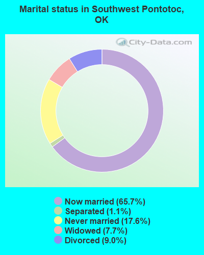
- Never married: 17.6%
- Now married: 65.7%
- Separated: 1.1%
- Widowed: 7.7%
- Divorced: 9.0%
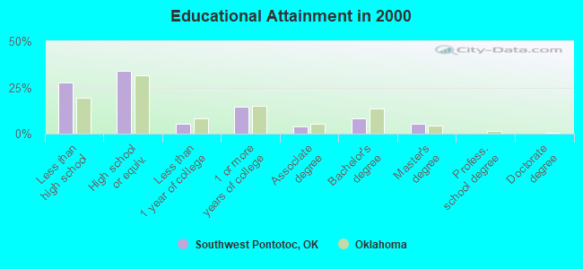
For population 25 years and over in Southwest Pontotoc:
- High school or higher: 72.2%
- Bachelor's degree or higher: 14.2%
- Graduate or professional degree: 5.7%
- Unemployed: 5.0%
- Mean travel time to work (commute): 23.2 minutes
| Here: | 12.8 |
| Oklahoma average: | 11.7 |
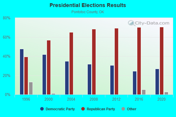
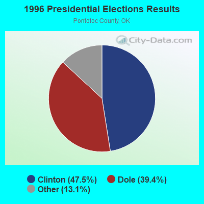
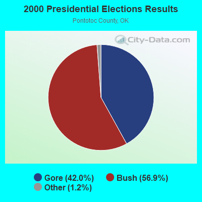


Graphs represent county-level data. Detailed 2008 Election Results
Religion statistics for Southwest Pontotoc, OK (based on Pontotoc County data)
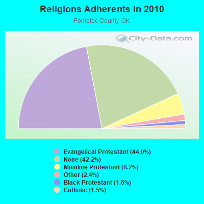
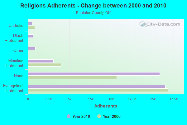
| Religion | Adherents | Congregations |
|---|---|---|
| Evangelical Protestant | 16,504 | 85 |
| Mainline Protestant | 3,076 | 11 |
| Other | 890 | 4 |
| Black Protestant | 613 | 2 |
| Catholic | 574 | 1 |
| None | 15,835 | - |
Food Environment Statistics:
| Pontotoc County: | 1.10 / 10,000 pop. |
| Oklahoma: | 1.97 / 10,000 pop. |
| Pontotoc County: | 0.27 / 10,000 pop. |
| Oklahoma: | 0.20 / 10,000 pop. |
| Pontotoc County: | 0.55 / 10,000 pop. |
| Oklahoma: | 0.76 / 10,000 pop. |
| Pontotoc County: | 4.93 / 10,000 pop. |
| Oklahoma: | 4.35 / 10,000 pop. |
| Pontotoc County: | 7.12 / 10,000 pop. |
| Oklahoma: | 6.89 / 10,000 pop. |
| Here: | 10.2% |
| Oklahoma: | 10.3% |
| Pontotoc County: | 31.2% |
| Oklahoma: | 29.2% |
Strongest AM radio stations in Southwest Pontotoc:
- KOMA (1520 AM; 50 kW; OKLAHOMA CITY, OK; Owner: RENDA BROADCASTING CORP. OF NEVADA)
- KRMG (740 AM; 50 kW; TULSA, OK; Owner: CXR HOLDINGS, INC.)
- KADA (1230 AM; 1 kW; ADA, OK; Owner: THE CHICKASAW NATION)
- KRLD (1080 AM; 50 kW; DALLAS, TX; Owner: TEXAS INFINITY BROADCASTING L.P.)
- KEOR (1110 AM; daytime; 5 kW; ATOKA, OK; Owner: DALLAS AM RADIO PARTNERS, L.P.)
- WBAP (820 AM; 50 kW; FORT WORTH, TX; Owner: WBAP-KSCS OPERATING, LTD.)
- KFAQ (1170 AM; 50 kW; TULSA, OK; Owner: JOURNAL BROADCAST CORPORATION)
- KFXR (1190 AM; 50 kW; DALLAS, TX; Owner: CLEAR CHANNEL BROADCASTING LICENSES, INC.)
- KYNG (950 AM; 10 kW; DENISON-SHERMAN, TX; Owner: KRBE LICO, INC.)
- KESS (1270 AM; 50 kW; FORT WORTH, TX; Owner: KESS-AM LICENSE CORP.)
- KAHZ (1360 AM; 50 kW; HURST, TX)
- KZMP (1540 AM; 50 kW; UNIVERSITY PARK, TX; Owner: ENTRAVISION HOLDINGS, LLC)
- WWLS (640 AM; 5 kW; MOORE, OK; Owner: CITADEL BROADCASTING COMPANY)
Strongest FM radio stations in Southwest Pontotoc:
- KIXO (106.1 FM; SULPHUR, OK; Owner: DFWU, INC.)
- KADA-FM (99.3 FM; ADA, OK; Owner: THE CHICKASAW NATION)
- K209AZ (89.7 FM; ADA, OK; Owner: CREATIVE EDUCATIONAL MEDIA CORP. INC)
- KAZC (88.3 FM; TISHOMINGO, OK; Owner: SOUTH CENTRAL OKLAHOMA CHRISTIAN BROADCASTING, INC.)
- KFXT (90.7 FM; SULPHUR, OK; Owner: SISTER SHERRY LYNN FOUNDATION, INC.)
- KYKC (100.1 FM; BYNG, OK; Owner: CENTRAL OKLAHOMA COMMUNICATIONS CO.)
- KQCV-FM (95.1 FM; SHAWNEE, OK; Owner: COMMUNITY BROADCASTING, INC)
- K204BX (88.7 FM; ADA, OK; Owner: AMERICAN FAMILY ASSOCIATION)
- KTGS (89.9 FM; ADA, OK; Owner: S CENTRAL OK CHRISTIAN BROADC/G INC)
- KMAD-FM (102.5 FM; WHITESBORO, TX; Owner: NM LICENSING, LLC)
TV broadcast stations around Southwest Pontotoc:
- KTEN (Channel 10; ADA, OK; Owner: CHANNEL 49 ACQUISITION CORPORATION)
- K35CU (Channel 35; ADA, OK; Owner: LOCKE SUPPLY CO.)
- KXII (Channel 12; SHERMAN, TX; Owner: KXII LICENSEE CORP.)
- K44BQ (Channel 44; ARDMORE, OK; Owner: TRINITY BROADCASTING NETWORK)
- K32EK (Channel 32; ARDMORE, OK; Owner: LOCKE SUPPLY COMPANY)
- KOKT-LP (Channel 20; SULPHUR, OK; Owner: EQUITY BROADCASTING CORPORATION)
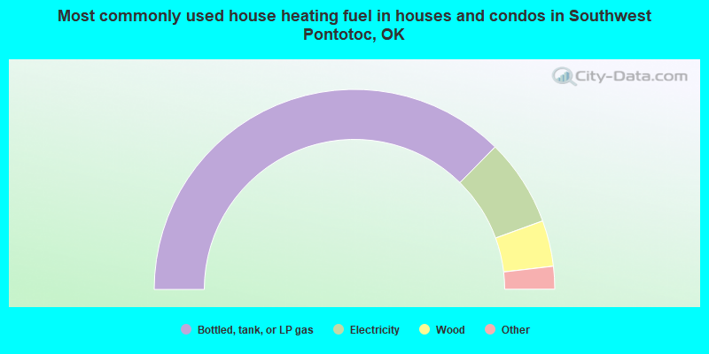
- 74.8%Bottled, tank, or LP gas
- 14.1%Electricity
- 7.4%Wood
- 2.0%Utility gas
- 1.7%Other fuel
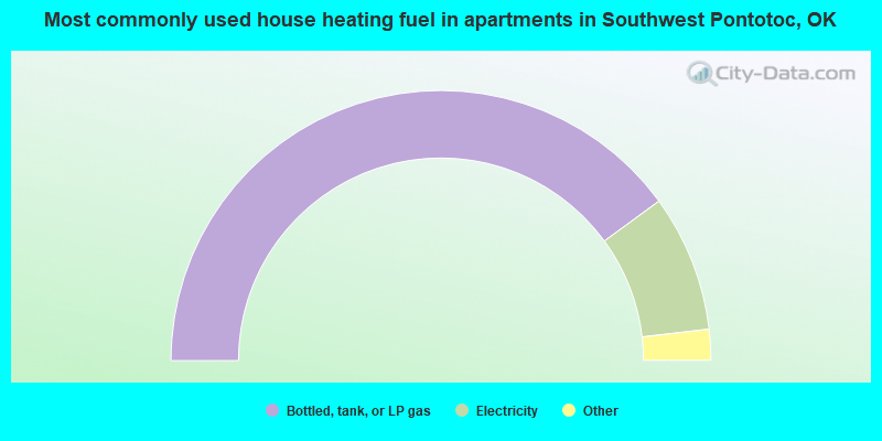
- 79.9%Bottled, tank, or LP gas
- 16.4%Electricity
- 2.2%No fuel used
- 1.5%Utility gas
Southwest Pontotoc compared to Oklahoma state average:
- Median house value below state average.
- Unemployed percentage below state average.
- Black race population percentage significantly below state average.
- Hispanic race population percentage significantly below state average.
- Foreign-born population percentage significantly below state average.
- Length of stay since moving in significantly above state average.
- Number of rooms per house significantly below state average.
- House age significantly below state average.