Tongue River, Montana
Submit your own pictures of this place and show them to the world
- OSM Map
- General Map
- Google Map
- MSN Map

| Males: 73 | |
| Females: 73 |
| Median resident age: | 41.5 years |
| Montana median age: | 37.5 years |
Zip code: 59025
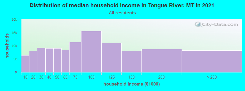
| Tongue River: | $39,444 |
| MT: | $67,631 |
Estimated per capita income in 2022: $24,496 (it was $11,944 in 2000)
Estimated median house or condo value in 2022: $152,676 (it was $47,300 in 2000)
| Tongue River: | $152,676 |
| MT: | $366,400 |
Mean prices in 2022: all housing units: $207,922; detached houses: $239,562; townhouses or other attached units: $150,967; mobile homes: $58,448
Detailed information about poverty and poor residents in Tongue River, MT


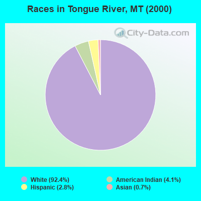
- 13492.4%White alone
- 64.1%American Indian alone
- 42.8%Hispanic
- 10.7%Asian alone
 Recent articles from our blog. Our writers, many of them Ph.D. graduates or candidates, create easy-to-read articles on a wide variety of topics.

Current Local Time: MST time zone
Land area: 607.1 square miles.
Population density: 0.2 people per square mile (very low).
| Tongue River CCD: | 0.0% ($0) |
| Montana: | 1.3% ($1,212) |
Nearest city with pop. 50,000+: Billings, MT  (98.5 miles , pop. 89,847).
Nearest city with pop. 200,000+: West Adams, CO (373.6 miles , pop. 259,628).
Nearest city with pop. 1,000,000+: Phoenix, AZ (850.5 miles , pop. 1,321,045).
Nearest cities:
), ), ), Latitude: 45.12 N, Longitude: 106.74 W

| Here: | 5.7% |
| Montana: | 3.8% |
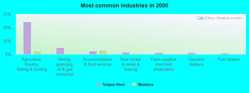
- Agriculture, forestry, fishing & hunting (61.3%)
- Mining, quarrying, oil & gas extraction (12.9%)
- Accommodation & food services (6.5%)
- Real estate & rental & leasing (4.3%)
- Farm supplies merchant wholesalers (3.2%)
- Gasoline stations (3.2%)
- Fuel dealers (2.2%)
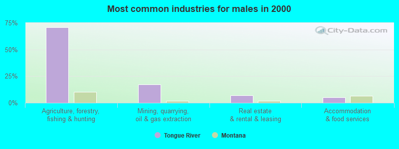
- Agriculture, forestry, fishing & hunting (70.7%)
- Mining, quarrying, oil & gas extraction (17.2%)
- Real estate & rental & leasing (6.9%)
- Accommodation & food services (5.2%)
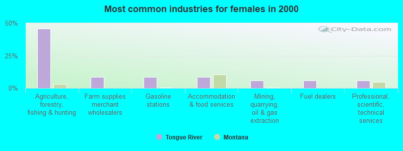
- Agriculture, forestry, fishing & hunting (45.7%)
- Farm supplies merchant wholesalers (8.6%)
- Gasoline stations (8.6%)
- Accommodation & food services (8.6%)
- Mining, quarrying, oil & gas extraction (5.7%)
- Fuel dealers (5.7%)
- Professional, scientific, technical services (5.7%)
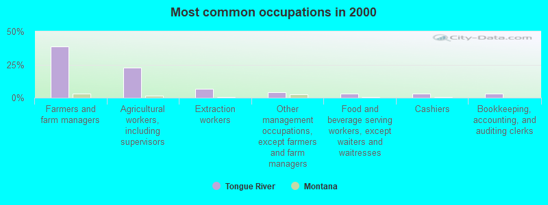
- Farmers and farm managers (38.7%)
- Agricultural workers, including supervisors (22.6%)
- Extraction workers (6.5%)
- Other management occupations, except farmers and farm managers (4.3%)
- Food and beverage serving workers, except waiters and waitresses (3.2%)
- Cashiers (3.2%)
- Bookkeeping, accounting, and auditing clerks (3.2%)
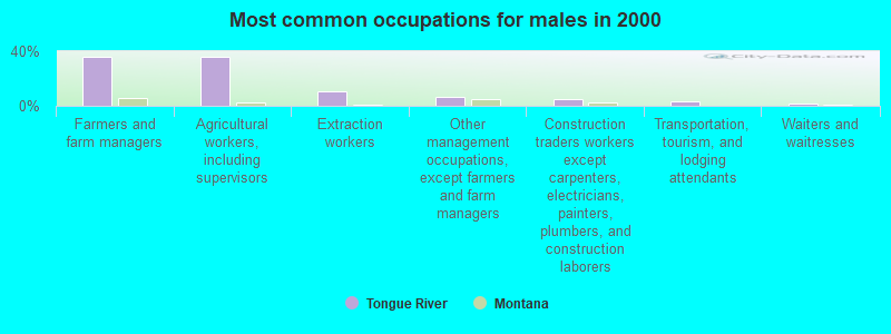
- Farmers and farm managers (36.2%)
- Agricultural workers, including supervisors (36.2%)
- Extraction workers (10.3%)
- Other management occupations, except farmers and farm managers (6.9%)
- Construction traders workers except carpenters, electricians, painters, plumbers, and construction laborers (5.2%)
- Transportation, tourism, and lodging attendants (3.4%)
- Waiters and waitresses (1.7%)
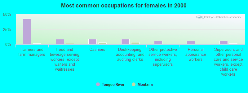
- Farmers and farm managers (42.9%)
- Food and beverage serving workers, except waiters and waitresses (8.6%)
- Cashiers (8.6%)
- Bookkeeping, accounting, and auditing clerks (8.6%)
- Other protective service workers, including supervisors (5.7%)
- Personal appearance workers (5.7%)
- Supervisors and other personal care and service workers, except child care workers (5.7%)
Average climate in Tongue River, Montana
Based on data reported by over 4,000 weather stations


(lower is better)
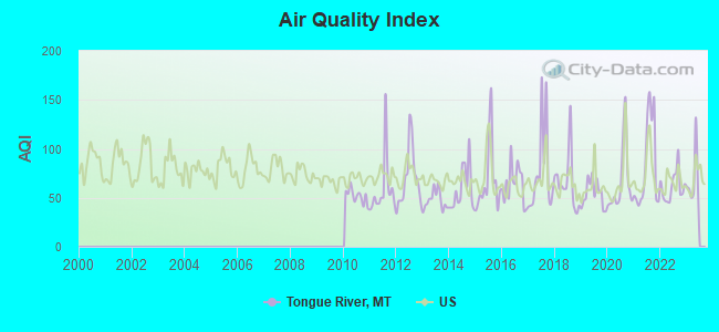
Air Quality Index (AQI) level in 2022 was 61.4. This is about average.
| City: | 61.4 |
| U.S.: | 72.6 |
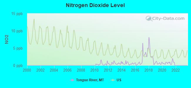
Nitrogen Dioxide (NO2) [ppb] level in 2021 was 0.800. This is significantly better than average. Closest monitor was 21.1 miles away from the city center.
| City: | 0.800 |
| U.S.: | 5.109 |
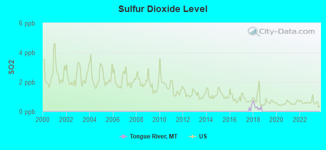
Sulfur Dioxide (SO2) [ppb] level in 2018 was 0.324. This is significantly better than average. Closest monitor was 13.8 miles away from the city center.
| City: | 0.324 |
| U.S.: | 1.515 |
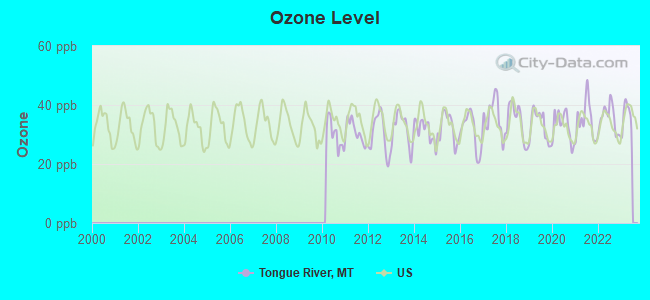
Ozone [ppb] level in 2022 was 35.5. This is about average. Closest monitor was 13.8 miles away from the city center.
| City: | 35.5 |
| U.S.: | 33.3 |
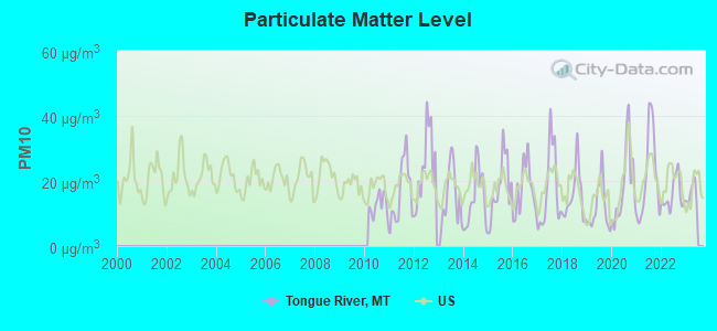
Particulate Matter (PM10) [µg/m3] level in 2022 was 15.7. This is better than average. Closest monitor was 4.4 miles away from the city center.
| City: | 15.7 |
| U.S.: | 19.2 |
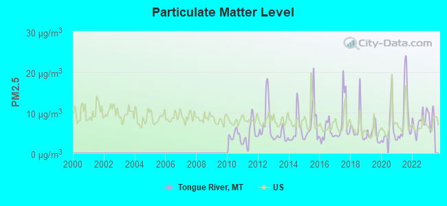
Particulate Matter (PM2.5) [µg/m3] level in 2022 was 7.60. This is about average. Closest monitor was 21.1 miles away from the city center.
| City: | 7.60 |
| U.S.: | 8.11 |
Earthquake activity:
Tongue River-area historical earthquake activity is significantly above Montana state average. It is 475% greater than the overall U.S. average.On 8/18/1959 at 06:37:13, a magnitude 7.7 (7.7 UK, Class: Major, Intensity: VIII - XII) earthquake occurred 195.6 miles away from Tongue River center, causing $26,000,000 total damage
On 10/28/1983 at 14:06:06, a magnitude 7.3 (6.2 MB, 7.3 MS, 7.0 MW) earthquake occurred 354.9 miles away from the city center, causing 2 deaths (2 shaking deaths) and 3 injuries, causing $15,000,000 total damage
On 6/30/1975 at 18:54:13, a magnitude 6.1 (5.6 MB, 5.9 MS, 6.1 UK, 6.1 ML, Class: Strong, Intensity: VII - IX) earthquake occurred 198.0 miles away from Tongue River center
On 9/8/1984 at 00:59:31, a magnitude 5.1 (5.1 MB, Class: Moderate, Intensity: VI - VII) earthquake occurred 73.6 miles away from Tongue River center
On 5/29/1984 at 20:18:32, a magnitude 5.0 (5.0 MB) earthquake occurred 72.4 miles away from Tongue River center
On 10/18/1984 at 15:30:23, a magnitude 5.5 (5.4 MB, 5.1 MS, 5.5 ML) earthquake occurred 197.4 miles away from the city center
Magnitude types: body-wave magnitude (MB), local magnitude (ML), surface-wave magnitude (MS), moment magnitude (MW)
Natural disasters:
The number of natural disasters in Big Horn County (6) is a lot smaller than the US average (15).Major Disasters (Presidential) Declared: 4
Emergencies Declared: 1
Causes of natural disasters: Storms: 3, Floods: 2, Fire: 1, Hurricane: 1, Other: 1 (Note: some incidents may be assigned to more than one category).
Colleges/universities with over 2000 students nearest to Tongue River:
- Sheridan College (about 27 miles; Sheridan, WY; Full-time enrollment: 2,070)
- Montana State University-Billings (about 99 miles; Billings, MT; FT enrollment: 4,319)
- Black Hills State University (about 148 miles; Spearfish, SD; FT enrollment: 3,166)
- Casper College (about 160 miles; Casper, WY; FT enrollment: 2,770)
- South Dakota School of Mines and Technology (about 189 miles; Rapid City, SD; FT enrollment: 2,102)
- Montana State University (about 213 miles; Bozeman, MT; FT enrollment: 12,942)
- Chadron State College (about 245 miles; Chadron, NE; FT enrollment: 2,374)
Points of interest:
Notable locations in Tongue River: Brewster Camp (A), OW Ranch (B), Forks Ranch (C), Tongue River Reservoir Campground (D), Holmes Ranch (E), Monument Hill (F), Hosford Camp (G), Decker (H), Jordan Ranch (I), Porter Ranch (J). Display/hide their locations on the map
Church in Tongue River: Saint Francis Church (A). Display/hide its location on the map
Reservoirs: Lower Indian Creek Reservoir (A), Tongue River Reservoir (B). Display/hide their locations on the map
Streams, rivers, and creeks: Wrench Creek (A), Anderson Creek (B), Cache Creek (C), Clarks Fork Canyon Creek (D), Coal Bank Creek (E), Dale Creek (F), Deep Creek (G), Deer Creek (H), Elk Creek (I). Display/hide their locations on the map
Parks in Tongue River include: Tongue River Reservoir State Park (1), Rosebud Battlefield State Park (2). Display/hide their locations on the map
| This place: | 2.2 people |
| Montana: | 2.5 people |
| This place: | 43.1% |
| Whole state: | 66.6% |
| This place: | 4.6% |
| Whole state: | 5.0% |
No gay or lesbian households reported
| This place: | 12.2% |
| Whole state: | 14.6% |
| This place: | 6.5% |
| Whole state: | 5.8% |
For population 15 years and over in Tongue River:
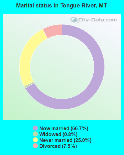
- Never married: 25.0%
- Now married: 66.7%
- Separated: 0.0%
- Widowed: 0.8%
- Divorced: 7.5%
For population 25 years and over in Tongue River:
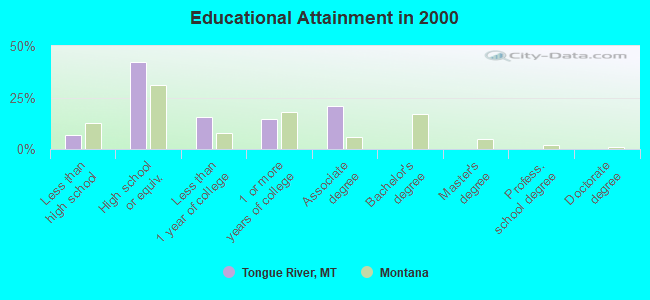
- High school or higher: 93.3%
- Bachelor's degree or higher: 0.0%
- Graduate or professional degree: 0.0%
- Unemployed: 5.1%
- Mean travel time to work (commute): 27.8 minutes
| Here: | 4.5 |
| Montana average: | 10.4 |
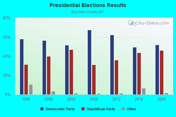
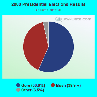
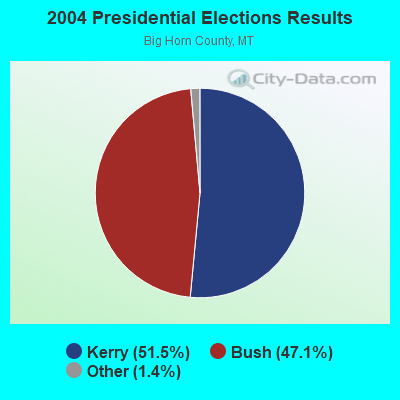
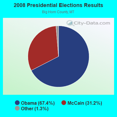
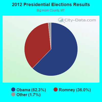
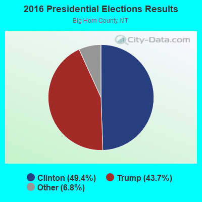
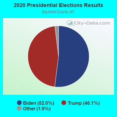
Graphs represent county-level data. Detailed 2008 Election Results
Religion statistics for Tongue River, MT (based on Big Horn County data)
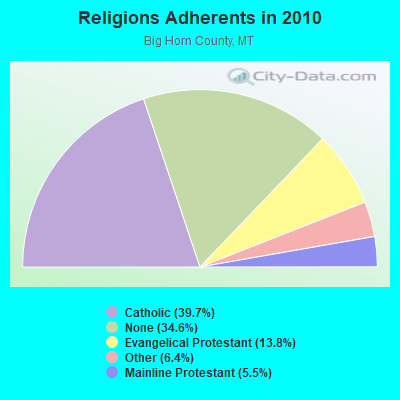
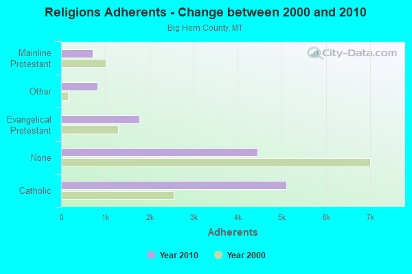
| Religion | Adherents | Congregations |
|---|---|---|
| Catholic | 5,102 | 6 |
| Evangelical Protestant | 1,770 | 21 |
| Other | 825 | 4 |
| Mainline Protestant | 711 | 8 |
| None | 4,457 | - |
Food Environment Statistics:
| This county: | 2.35 / 10,000 pop. |
| Montana: | 2.55 / 10,000 pop. |
| Big Horn County: | 0.78 / 10,000 pop. |
| Montana: | 0.48 / 10,000 pop. |
| This county: | 10.18 / 10,000 pop. |
| Montana: | 4.69 / 10,000 pop. |
| This county: | 5.48 / 10,000 pop. |
| Montana: | 10.38 / 10,000 pop. |
| This county: | 11.6% |
| State: | 7.2% |
| Big Horn County: | 32.4% |
| Montana: | 23.1% |
| Big Horn County: | 19.8% |
| State: | 10.7% |
Strongest AM radio stations in Tongue River:
- KROE (930 AM; 5 kW; SHERIDAN, WY; Owner: LOVCOM, INC.)
- KWYO (1410 AM; 5 kW; SHERIDAN, WY; Owner: KWYO AM, LLC)
- KTWO (1030 AM; 50 kW; CASPER, WY; Owner: CITICASTERS LICENSES, L.P.)
- KZMQ (1140 AM; daytime; 10 kW; GREYBULL, WY; Owner: LEGEND COMMUNICATIONS OF WYOMING LLC)
- KATL (770 AM; 10 kW; MILES CITY, MT; Owner: STAR PRINTING COMPANY)
- KUYO (830 AM; daytime; 25 kW; EVANSVILLE, WY; Owner: WYOMING CHRISTIAN BROADCASTING COMPANY)
- KBHB (810 AM; 25 kW; STURGIS, SD; Owner: MONTEREY LICENSES, LLC)
- KMTA (1050 AM; 10 kW; MILES CITY, MT; Owner: SENGER BROADCASTING CORPORATION)
- KURL (730 AM; 5 kW; BILLINGS, MT; Owner: ELENBAAS MEDIA, INC.)
- KXMR (710 AM; 50 kW; BISMARCK, ND; Owner: RADIO BISMARCK MANDAN, LLC)
- KIKC (1250 AM; 5 kW; FORSYTH, MT; Owner: MILES CITY, FORSYTH B/DCSTG, INC.)
- KGHL (790 AM; 5 kW; BILLINGS, MT; Owner: NEW NORTHWEST BROADCASTERS, LLC)
- KIML (1270 AM; 5 kW; GILLETTE, WY; Owner: GILLETTE BROADCASTING CO.)
Strongest FM radio stations in Tongue River:
- KZZS (98.3 FM; STORY, WY; Owner: LEGEND COMMUNICATIONS OF WYOMING, L.L.C.)
- K244CK (96.7 FM; COWLEY, ETC., WY; Owner: CONNECTION COMMUNICATIONS ASSOC., INC.)
- KZMQ-FM (100.3 FM; GREYBULL, WY; Owner: LEGEND COMMUNICATIONS OF WYOMING LLC)
- KSUW (91.3 FM; SHERIDAN, WY; Owner: UNIVERSITY OF WYOMING)
- KYTI (93.7 FM; SHERIDAN, WY; Owner: LOVCOM, INC.)
- KZWY (94.9 FM; SHERIDAN, WY; Owner: LOVCOM, INC.)
- KLGT (92.9 FM; BUFFALO, WY; Owner: LEGEND COMMUNICATIONS OF WYOMING, L.L.C.)
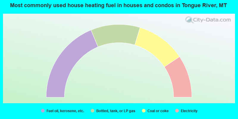
- 37.5%Fuel oil, kerosene, etc.
- 21.9%Bottled, tank, or LP gas
- 21.9%Coal or coke
- 18.8%Electricity
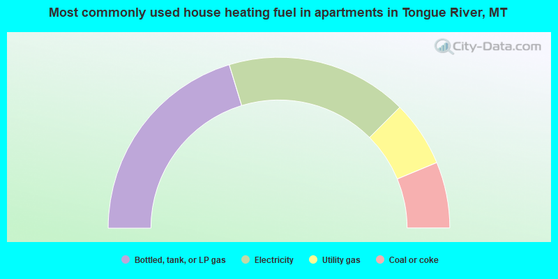
- 40.6%Bottled, tank, or LP gas
- 34.4%Electricity
- 12.5%Utility gas
- 12.5%Coal or coke
Tongue River compared to Montana state average:
- Median household income below state average.
- Median house value significantly below state average.
- Unemployed percentage below state average.
- Black race population percentage significantly below state average.
- Foreign-born population percentage significantly below state average.
- Renting percentage significantly below state average.
- Length of stay since moving in significantly above state average.
- Number of rooms per house significantly below state average.
- House age significantly below state average.
- Number of college students significantly below state average.
- Percentage of population with a bachelor's degree or higher significantly below state average.