Turkeytown, Alabama
Submit your own pictures of this place and show them to the world
- OSM Map
- General Map
- Google Map
- MSN Map

| Males: 1,889 | |
| Females: 1,903 |
| Median resident age: | 37.9 years |
| Alabama median age: | 35.8 years |
Zip code: 35901
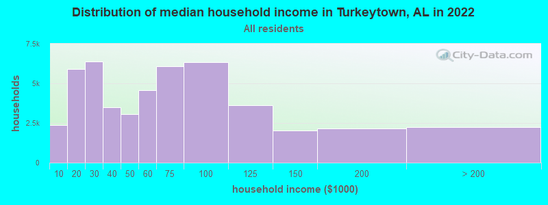
| Turkeytown: | $68,985 |
| AL: | $59,674 |
Estimated per capita income in 2022: $27,079 (it was $15,964 in 2000)
Turkeytown CCD income, earnings, and wages data
Estimated median house or condo value in 2022: $176,966 (it was $70,300 in 2000)
| Turkeytown: | $176,966 |
| AL: | $200,900 |
Mean prices in 2022: all housing units: $187,963; detached houses: $194,719; townhouses or other attached units: $281,506; in 2-unit structures: $137,818; mobile homes: $100,707; occupied boats, rvs, vans, etc.: $9,829
Detailed information about poverty and poor residents in Turkeytown, AL
Compare current foreclosures near Turkeytown, AL:
| Photo | Address | Area | Beds / Baths | Price | Details |
|---|---|---|---|---|---|

|
#1
Sibert Dr
Gadsden, AL 35905
|
3,094 sq. feet
|
3 baths 3 beds |
$394,900
|
show details |

|
#2
Edgar Rd
Gadsden, AL 35905
|
1,765 sq. feet
|
2 baths 3 beds |
$99,900
|
show details |

|
#3
Ponderosa Rd
Attalla, AL 35954
|
1,396 sq. feet
|
2 baths 3 beds |
$234,500
|
show details |

|
#4
E Tomahawk Trl
Gadsden, AL 35903
|
- sq. feet
|
1 baths 3 beds |
$64,000
|
show details |

|
#5
Al Hwy 9 S
Piedmont, AL 36272
|
3,200 sq. feet
|
- baths 4 beds |
$329,900
|
show details |

|
#6
Laura Ln
Gadsden, AL 35907
|
2,531 sq. feet
|
2 baths 3 beds |
show details | |

|
#7
County Road 51
Collinsville, AL 35961
|
3,099 sq. feet
|
3 baths 3 beds |
show details | |

|
#8
S Hawk Dr
Rainbow City, AL 35906
|
3,070 sq. feet
|
3 baths 4 beds |
show details | |

|
#9
Us Highway 278 E
Gadsden, AL 35903
|
1,171 sq. feet
|
1 baths 3 beds |
show details | |

|
#10
Mintwood Way
Gadsden, AL 35905
|
1,928 sq. feet
|
1 baths 4 beds |
show details |
| Photo | Address | Area | Beds / Baths | Price | Details |
|---|---|---|---|---|---|

|
#11
Mountain Dr
Gadsden, AL 35904
|
2,700 sq. feet
|
2 baths 3 beds |
show details | |

|
#12
Colvin Cir N
Gadsden, AL 35907
|
1,950 sq. feet
|
2 baths 3 beds |
show details | |

|
#13
Dogwood Ln
Piedmont, AL 36272
|
2,010 sq. feet
|
2 baths 3 beds |
show details | |

|
#14
Goss Ave
Gadsden, AL 35903
|
1,164 sq. feet
|
2 baths 3 beds |
show details | |

|
#15
Lookout St
Gadsden, AL 35904
|
1,772 sq. feet
|
2 baths 3 beds |
show details | |

|
#16
Co Rd 162
Crossville, AL 35962
|
- sq. feet
|
3 baths 3 beds |
show details | |

|
#17
Piedmont Ave
Gadsden, AL 35904
|
1,434 sq. feet
|
1 baths - beds |
show details | |

|
#18
Beale St NW
Attalla, AL 35954
|
2,109 sq. feet
|
1 baths - beds |
show details | |

|
#19
Mountain Creek Dr
Gadsden, AL 35901
|
2,720 sq. feet
|
2 baths - beds |
show details | |

|
#20
County Road 69
Centre, AL 35960
|
1,805 sq. feet
|
2 baths 3 beds |
show details |
| Photo | Address | Area | Beds / Baths | Price | Details |
|---|---|---|---|---|---|

|
#21
Green Valley Rd
Gadsden, AL 35907
|
- sq. feet
|
2 baths 3 beds |
show details | |

|
#22
2nd Ave NW
Attalla, AL 35954
|
1,286 sq. feet
|
1 baths - beds |
show details | |

|
#23
Florida Ave
Gadsden, AL 35903
|
1,271 sq. feet
|
1 baths - beds |
show details | |

|
#24
Herzberg Cir
Gadsden, AL 35903
|
1,354 sq. feet
|
1 baths - beds |
show details | |

|
#25
Randolph St SE
Attalla, AL 35954
|
1,885 sq. feet
|
1 baths - beds |
show details | |

|
#26
Tuckahoe Cir
Gadsden, AL 35904
|
1,888 sq. feet
|
1 baths - beds |
show details | |

|
#27
Mountain Brook Dr
Gadsden, AL 35901
|
1,512 sq. feet
|
1 baths - beds |
show details | |

|
#28
Meadow Wood Rd
Gadsden, AL 35901
|
2,392 sq. feet
|
1 baths - beds |
show details | |

|
#29
Bill Jon Dr
Rainbow City, AL 35906
|
1,458 sq. feet
|
1 baths - beds |
show details | |

|
#30
N 32nd St
Gadsden, AL 35904
|
1,897 sq. feet
|
1 baths - beds |
show details |
| Photo | Address | Area | Beds / Baths | Price | Details |
|---|---|---|---|---|---|

|
#31
Monte Vista Dr
Gadsden, AL 35904
|
1,473 sq. feet
|
1 baths - beds |
show details | |

|
#32
Rosser Blvd
Boaz, AL 35956
|
3,639 sq. feet
|
1 baths - beds |
show details | |

|
#33
Windsor St
Gadsden, AL 35903
|
2,117 sq. feet
|
1 baths - beds |
show details | |

|
#34
Hill Ave
Gadsden, AL 35904
|
1,272 sq. feet
|
1 baths - beds |
show details | |

|
#35
Country Club Dr
Gadsden, AL 35901
|
3,142 sq. feet
|
1 baths - beds |
show details | |

|
#36
Rainbow Dr
Rainbow City, AL 35906
|
2,800 sq. feet
|
1 baths - beds |
show details | |

|
#37
Kenwood Cir
Gadsden, AL 35904
|
2,050 sq. feet
|
1 baths - beds |
show details | |

|
#38
Anna Dr
Attalla, AL 35954
|
2,240 sq. feet
|
1 baths - beds |
show details | |

|
#39
Geurin Rd
Gadsden, AL 35905
|
1,312 sq. feet
|
1 baths - beds |
show details | |

|
#40
Padenreich Ave
Gadsden, AL 35903
|
3,559 sq. feet
|
1 baths - beds |
show details |
| Photo | Address | Area | Beds / Baths | Price | Details |
|---|---|---|---|---|---|

|
#41
Rolling Hills Rd
Gadsden, AL 35901
|
1,152 sq. feet
|
1 baths - beds |
show details | |

|
#42
Oakdale Dr
Gadsden, AL 35903
|
2,092 sq. feet
|
1 baths - beds |
show details | |

|
#43
Robertson St W
Gadsden, AL 35907
|
1,826 sq. feet
|
1 baths - beds |
show details | |

|
#44
Johnson Rd
Gadsden, AL 35901
|
1,712 sq. feet
|
1 baths - beds |
show details | |

|
#45
Berkley Hills Dr E
Gadsden, AL 35907
|
2,458 sq. feet
|
1 baths - beds |
show details | |

|
#46
Laura Ln
Attalla, AL 35954
|
1,152 sq. feet
|
1 baths - beds |
show details | |

|
#47
Argyle Cir
Gadsden, AL 35901
|
2,540 sq. feet
|
1 baths - beds |
show details | |

|
#48
W Sunset Dr
Gadsden, AL 35904
|
1,869 sq. feet
|
1 baths - beds |
show details | |

|
#49
Hawthorne Cir
Gadsden, AL 35907
|
1,958 sq. feet
|
1 baths - beds |
show details | |

|
Check over 1 million property listings on Foreclosure.com!
|
browse all offers | |||

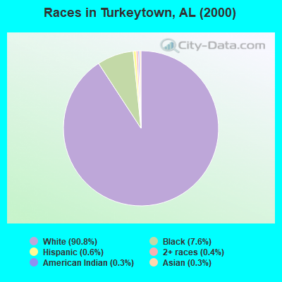
- 3,44590.8%White alone
- 2887.6%Black alone
- 240.6%Hispanic
- 170.4%Two or more races
- 120.3%American Indian alone
- 100.3%Asian alone
 Recent articles from our blog. Our writers, many of them Ph.D. graduates or candidates, create easy-to-read articles on a wide variety of topics.

Current Local Time: CST time zone
Elevation: 547 feet
Land area: 33.8 square miles.
Population density: 112 people per square mile (very low).

| Turkeytown CCD: | 0.3% ($221) |
| Alabama: | 0.4% ($289) |
Nearest city with pop. 50,000+: Huntsville, AL  (59.7 miles , pop. 158,216).
Nearest city with pop. 200,000+: Birmingham, AL (64.8 miles , pop. 242,820).
Nearest city with pop. 1,000,000+: Chicago, IL (546.1 miles , pop. 2,896,016).
Nearest cities:
), ), ), ), )Latitude: 34.07 N, Longitude: 85.90 W
Area code commonly used in this area: 256

| Here: | 2.9% |
| Alabama: | 2.6% |
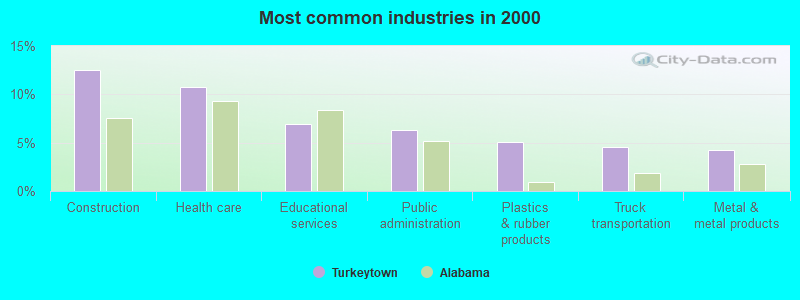
- Construction (12.6%)
- Health care (10.7%)
- Educational services (6.9%)
- Public administration (6.3%)
- Plastics & rubber products (5.0%)
- Truck transportation (4.6%)
- Metal & metal products (4.2%)
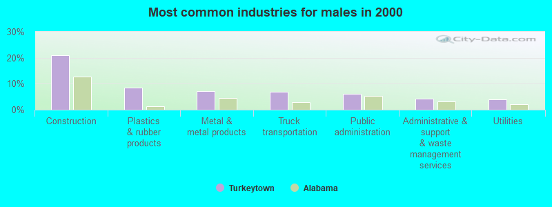
- Construction (21.0%)
- Plastics & rubber products (8.4%)
- Metal & metal products (7.1%)
- Truck transportation (6.9%)
- Public administration (6.2%)
- Administrative & support & waste management services (4.1%)
- Utilities (3.9%)
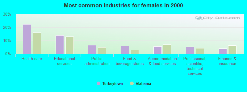
- Health care (22.4%)
- Educational services (14.0%)
- Public administration (6.5%)
- Food & beverage stores (6.1%)
- Accommodation & food services (5.6%)
- Professional, scientific, technical services (5.4%)
- Finance & insurance (3.9%)
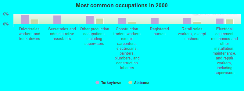
- Driver/sales workers and truck drivers (5.5%)
- Secretaries and administrative assistants (5.3%)
- Other production occupations, including supervisors (5.0%)
- Construction traders workers except carpenters, electricians, painters, plumbers, and construction laborers (3.9%)
- Registered nurses (3.7%)
- Retail sales workers, except cashiers (3.7%)
- Electrical equipment mechanics and other installation, maintenance, and repair workers, including supervisors (3.5%)
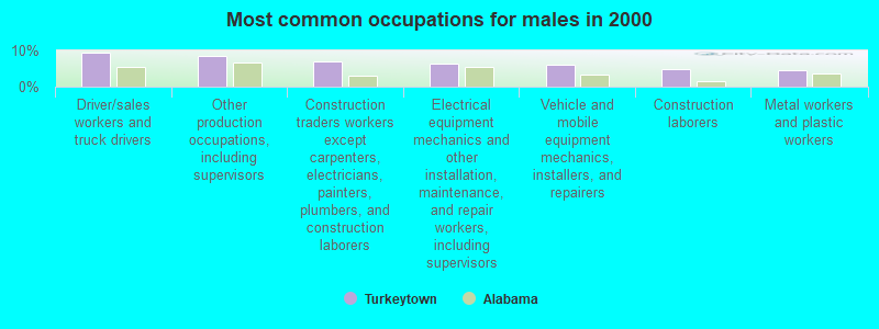
- Driver/sales workers and truck drivers (9.3%)
- Other production occupations, including supervisors (8.5%)
- Construction traders workers except carpenters, electricians, painters, plumbers, and construction laborers (7.0%)
- Electrical equipment mechanics and other installation, maintenance, and repair workers, including supervisors (6.3%)
- Vehicle and mobile equipment mechanics, installers, and repairers (6.2%)
- Construction laborers (4.8%)
- Metal workers and plastic workers (4.5%)

- Secretaries and administrative assistants (10.6%)
- Registered nurses (8.3%)
- Preschool, kindergarten, elementary, and middle school teachers (7.7%)
- Other sales and related occupations, including supervisors (6.1%)
- Health technologists and technicians (5.1%)
- Cashiers (3.8%)
- Customer service representatives (3.8%)
Average climate in Turkeytown, Alabama
Based on data reported by over 4,000 weather stations


(lower is better)
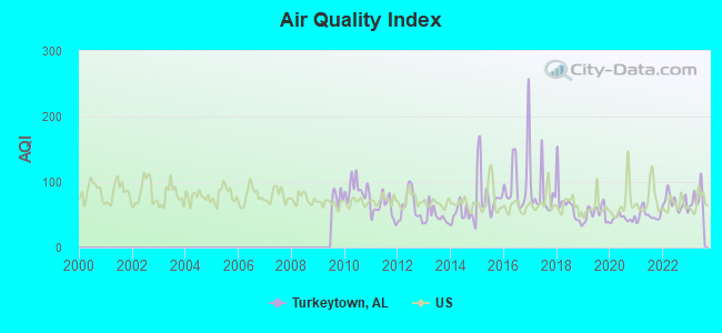
Air Quality Index (AQI) level in 2023 was 74.1. This is about average.
| City: | 74.1 |
| U.S.: | 72.6 |
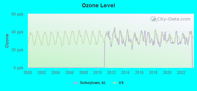
Ozone [ppb] level in 2023 was 35.5. This is about average. Closest monitor was 15.6 miles away from the city center.
| City: | 35.5 |
| U.S.: | 33.3 |
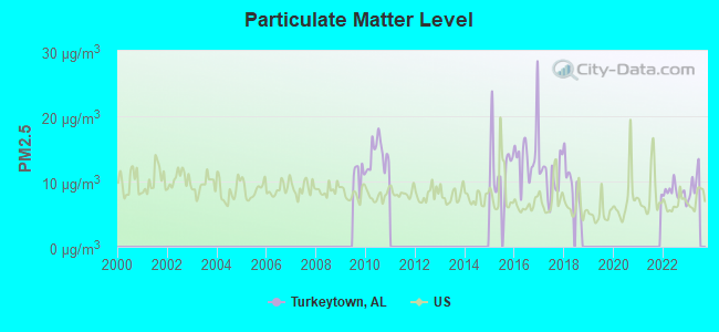
Particulate Matter (PM2.5) [µg/m3] level in 2022 was 8.35. This is about average. Closest monitor was 7.8 miles away from the city center.
| City: | 8.35 |
| U.S.: | 8.11 |
Tornado activity:
Turkeytown-area historical tornado activity is slightly above Alabama state average. It is 142% greater than the overall U.S. average.
On 11/18/1957, a category F4 (max. wind speeds 207-260 mph) tornado 23.1 miles away from the Turkeytown place center killed 3 people and injured 12 people and caused between $50,000 and $500,000 in damages.
On 11/24/2001, a category F4 tornado 23.3 miles away from the place center injured 22 people and caused $1 million in damages.
Earthquake activity:
Turkeytown-area historical earthquake activity is significantly above Alabama state average. It is 114% greater than the overall U.S. average.On 4/29/2003 at 08:59:39, a magnitude 4.9 (4.4 MB, 4.6 MW, 4.9 LG, Class: Light, Intensity: IV - V) earthquake occurred 33.0 miles away from the city center
On 4/29/2003 at 08:59:39, a magnitude 4.6 (4.6 MW, Depth: 12.3 mi) earthquake occurred 33.0 miles away from Turkeytown center
On 1/18/1999 at 07:00:53, a magnitude 4.8 (4.8 MB, 4.0 LG, Depth: 0.6 mi) earthquake occurred 90.7 miles away from the city center
On 6/24/1975 at 11:11:36, a magnitude 4.5 (4.5 MB) earthquake occurred 114.2 miles away from Turkeytown center
On 8/2/1974 at 08:52:09, a magnitude 4.9 (4.3 MB, 4.9 LG) earthquake occurred 196.0 miles away from Turkeytown center
On 11/30/1973 at 07:48:41, a magnitude 4.7 (4.7 MB, 4.6 ML) earthquake occurred 162.2 miles away from Turkeytown center
Magnitude types: regional Lg-wave magnitude (LG), body-wave magnitude (MB), local magnitude (ML), moment magnitude (MW)
Natural disasters:
The number of natural disasters in Etowah County (25) is a lot greater than the US average (15).Major Disasters (Presidential) Declared: 16
Emergencies Declared: 5
Causes of natural disasters: Storms: 14, Tornadoes: 11, Floods: 10, Hurricanes: 4, Winds: 4, Winter Storms: 2, Drought: 1, Fire: 1, Freeze: 1, Snowfall: 1, Other: 1 (Note: some incidents may be assigned to more than one category).
Hospitals and medical centers near Turkeytown:
- NORTHSIDE HEALTH CARE (Nursing Home, about 5 miles away; GADSDEN, AL)
- MOUNTAIN VIEW HOSPITAL (Hospital, about 6 miles away; GADSDEN, AL)
- GADSDEN REGIONAL MEDICAL CENTER Acute Care Hospitals (about 7 miles away; GADSDEN, AL)
- PCD OF GADSDEN (Dialysis Facility, about 7 miles away; GADSDEN, AL)
- SOUTHERNCARE GADSDEN (Hospital, about 7 miles away; GADSDEN, AL)
- ETOWAH COUNTY HOME CARE (Home Health Center, about 8 miles away; GADSDEN, AL)
- COOSA VALLEY HEALTH CARE (Nursing Home, about 9 miles away; GLENCOE, AL)
Colleges/universities with over 2000 students nearest to Turkeytown:
- Gadsden State Community College (about 8 miles; Gadsden, AL; Full-time enrollment: 4,650)
- Snead State Community College (about 19 miles; Boaz, AL; FT enrollment: 2,023)
- Jacksonville State University (about 19 miles; Jacksonville, AL; FT enrollment: 7,566)
- Northeast Alabama Community College (about 33 miles; Rainsville, AL; FT enrollment: 2,409)
- Georgia Highlands College (about 41 miles; Rome, GA; FT enrollment: 4,071)
- Georgia Northwestern Technical College (about 43 miles; Rome, GA; FT enrollment: 4,629)
- Berry College (about 44 miles; Mount Berry, GA; FT enrollment: 2,102)
Points of interest:
Notable locations in Turkeytown: Mountain View Fish Camp (A), Mountain View Camp (B), Tidmore Bend Volunteer Fire Department (C), Coates Bend Volunteer Fire Department (D). Display/hide their locations on the map
Churches in Turkeytown include: Mount Zion Church (A), Pascal Church (B), Ebenezer Baptist Church (C), Turkeytown Methodist Church (D), Full Gospel Tabernacle (E), Faith Baptist Church (F), Advent Church (G), Lebanon Church (H), Woodland Church (I). Display/hide their locations on the map
Cemeteries: Shepard Cemetery (1), Lebanon Cemetery (2), Croft Cemetery (3), Beulah Cemetery (4). Display/hide their locations on the map
Reservoirs: Estess Lake (A), Thorval Lake (B). Display/hide their locations on the map
Creeks: Dry Creek (A), Turkeytown Creek (B). Display/hide their locations on the map
| This place: | 2.6 people |
| Alabama: | 2.5 people |
| This place: | 74.3% |
| Whole state: | 67.8% |
| This place: | 3.4% |
| Whole state: | 4.7% |
Likely homosexual households (counted as self-reported same-sex unmarried-partner households)
- Lesbian couples: 0.3% of all households
- Gay men: 0.2% of all households
| This place: | 12.7% |
| Whole state: | 16.1% |
| This place: | 2.8% |
| Whole state: | 7.3% |
For population 15 years and over in Turkeytown:
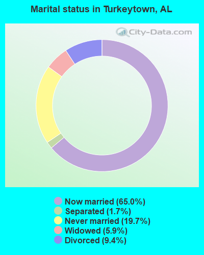
- Never married: 19.7%
- Now married: 65.0%
- Separated: 1.7%
- Widowed: 5.9%
- Divorced: 9.4%
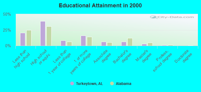
For population 25 years and over in Turkeytown:
- High school or higher: 79.7%
- Bachelor's degree or higher: 10.4%
- Graduate or professional degree: 4.3%
- Unemployed: 5.0%
- Mean travel time to work (commute): 32.3 minutes
| Here: | 10.5 |
| Alabama average: | 13.2 |
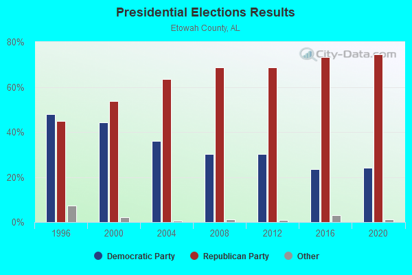
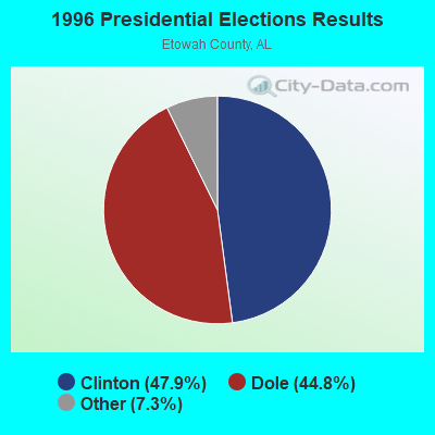
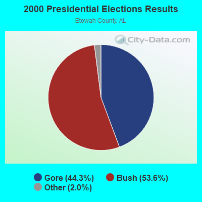
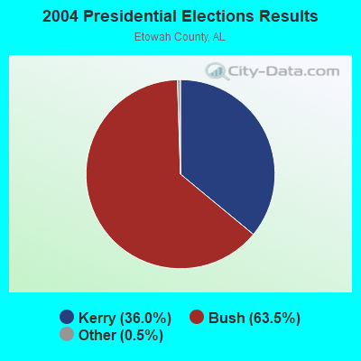
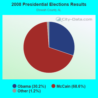


Graphs represent county-level data. Detailed 2008 Election Results
Religion statistics for Turkeytown, AL (based on Etowah County data)
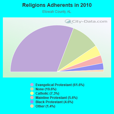
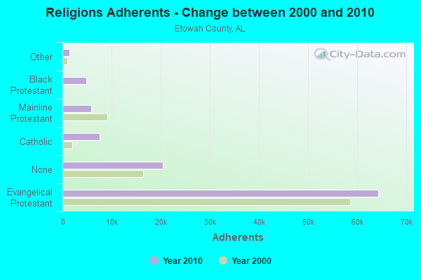
| Religion | Adherents | Congregations |
|---|---|---|
| Evangelical Protestant | 64,316 | 193 |
| Catholic | 7,624 | 1 |
| Mainline Protestant | 5,816 | 35 |
| Black Protestant | 4,813 | 21 |
| Other | 1,437 | 6 |
| None | 20,424 | - |
Food Environment Statistics:
| Etowah County: | 2.43 / 10,000 pop. |
| Alabama: | 1.89 / 10,000 pop. |
| Etowah County: | 0.78 / 10,000 pop. |
| State: | 0.65 / 10,000 pop. |
| Etowah County: | 6.21 / 10,000 pop. |
| State: | 6.32 / 10,000 pop. |
| Etowah County: | 4.95 / 10,000 pop. |
| Alabama: | 5.75 / 10,000 pop. |
| Here: | 10.7% |
| Alabama: | 11.8% |
| Etowah County: | 32.5% |
| State: | 31.7% |
| Etowah County: | 20.2% |
| State: | 13.5% |
Strongest AM radio stations in Turkeytown:
- WNSI (810 AM; 50 kW; JACKSONVILLE, AL; Owner: UNITED BROADCASTING NETWORK, INC.)
- WAAX (570 AM; 5 kW; GADSDEN, AL; Owner: CAPSTAR TX LIMITED PARTNERSHIP)
- WJBY (930 AM; 5 kW; RAINBOW CITY, AL; Owner: GADSDEN BROADCASTING COMPANY, INC.)
- WGAD (1350 AM; 5 kW; GADSDEN, AL; Owner: DEKALB COUNTY COMMUNITY RADIO, INC.)
- WKNG (1060 AM; daytime; 50 kW; TALLAPOOSA, GA; Owner: WKNG, INC.)
- WDJC (850 AM; 50 kW; BIRMINGHAM, AL; Owner: KIMTRON, INC.)
- WJOX (690 AM; 50 kW; BIRMINGHAM, AL; Owner: CITADEL BROADCASTING COMPANY)
- WWAM (820 AM; daytime; 50 kW; JASPER, TN; Owner: SHELTON BROADCASTING SYSTEM)
- WGST (640 AM; 50 kW; ATLANTA, GA; Owner: CITICASTERS LICENSES, L.P.)
- WAPI (1070 AM; 50 kW; BIRMINGHAM, AL; Owner: CITADEL BROADCASTING COMPANY)
- WMGJ (1240 AM; 1 kW; GADSDEN, AL; Owner: FLOYD L. DONALD BROADCASTING CO. INC)
- WFTD (1080 AM; daytime; 50 kW; MARIETTA, GA; Owner: PRIETO ENTERPRISES, INC.)
- WFLI (1070 AM; 50 kW; LOOKOUT MOUNTAIN, TN; Owner: WFLI, INC.)
Strongest FM radio stations in Turkeytown:
- WRHY (105.9 FM; CENTRE, AL; Owner: WILLIAMS COMMUNICATIONS, INC.)
- WTBB (89.9 FM; GADSDEN, AL; Owner: TRINITY CHRISTIAN ACADEMY)
- WQSB (105.1 FM; ALBERTVILLE, AL; Owner: SAND MOUNTAIN BROADCASTING SERVICE, INC.)
- WSGN (91.5 FM; GADSDEN, AL; Owner: GADSDEN STATE COMMUNITY COLLEGE)
- WGMZ (93.1 FM; GLENCOE, AL; Owner: CAPSTAR TX LIMITED PARTNERSHIP)
- WLJS-FM (91.9 FM; JACKSONVILLE, AL; Owner: BD. OF TRUSTEES/JACKSONVILLE STATE UNIVERSITY)
- WKXX (102.9 FM; ATTALLA, AL; Owner: BROADCAST MEDIA LLC)
- WTBJ (91.3 FM; OXFORD, AL; Owner: TRINITY CHRISTIAN ACADEMY)
- WVOK-FM (97.9 FM; OXFORD, AL; Owner: WOODARD BROADCASTING CO. INC.)
- WJCK (88.3 FM; PIEDMONT, AL; Owner: IMMANUEL BROADCASTING NETWORK, INC.)
- WRAX (107.7 FM; BIRMINGHAM, AL; Owner: CITADEL BROADCASTING COMPANY)
- W215BA (90.9 FM; ROME, GA; Owner: PENSACOLA CHRISTIAN COLLEGE, INC.)
- W269AX (101.7 FM; ANNISTON, AL; Owner: BIBLE BROADCASTING NETWORK, INC.)
- WTWX-FM (95.9 FM; GUNTERSVILLE, AL; Owner: GUNTERSVILLE BROADCASTING CO., INC.)
- WGRW (90.7 FM; ANNISTON, AL; Owner: WORD WORKS, INC.)
- WCKS (102.7 FM; FRUITHURST, AL; Owner: WCKS, INC.)
- WKCX (97.7 FM; ROME, GA; Owner: BRIAR CREEK BROADCASTING CORP.)
- WAFN-FM (92.7 FM; ARAB, AL; Owner: FUN MEDIA GROUP, INC.)
- W269AN (101.7 FM; GADSDEN, AL; Owner: JOHN S. LA TOUR/J & J B/C)
TV broadcast stations around Turkeytown:
- WPXH (Channel 44; GADSDEN, AL; Owner: PAXSON COMMUNICATIONS LICENSE COMPANY, LLC)
- W64BJ (Channel 64; SCOTTSBORO, AL; Owner: TRINITY BROADCASTING NETWORK)
- WTJP (Channel 60; GADSDEN, AL; Owner: TRINITY BROADCASTING NETWORK)
- W15AP (Channel 15; GADSDEN, AL; Owner: WBRC LICENSE, INC.)
- National Bridge Inventory (NBI) Statistics
- 1Number of bridges
- 3ft / 0.7mTotal length
- $1,354,000Total costs
- 16,322Total average daily traffic
- 1,305Total average daily truck traffic
- 22,851Total future (year 2039) average daily traffic
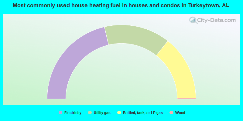
- 42.6%Electricity
- 28.8%Utility gas
- 28.2%Bottled, tank, or LP gas
- 0.4%Wood
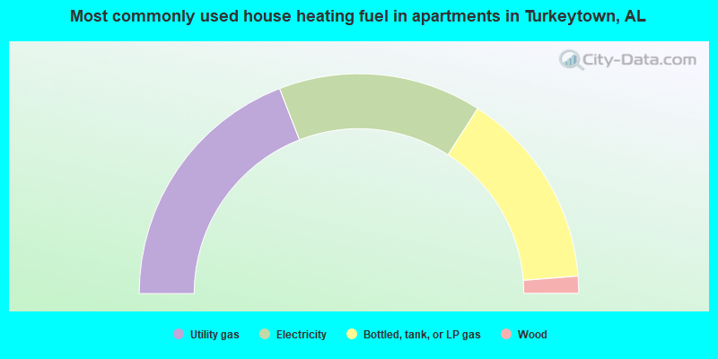
- 38.2%Utility gas
- 29.9%Electricity
- 29.3%Bottled, tank, or LP gas
- 2.5%Wood
Turkeytown compared to Alabama state average:
- Unemployed percentage significantly below state average.
- Black race population percentage significantly below state average.
- Hispanic race population percentage significantly below state average.
- Median age below state average.
- Foreign-born population percentage significantly below state average.
- Renting percentage below state average.
- Length of stay since moving in significantly above state average.
- Number of rooms per house significantly below state average.
- House age significantly below state average.
- Percentage of population with a bachelor's degree or higher below state average.
Turkeytown on our top lists:
- #95 on the list of "Top 101 larger cities with the lowest real estate taxes percentage (population 50,000+)"
- #13 on the list of "Top 101 counties with the highest number of deaths per 1000 residents 2007-2013 (pop. 50,000+)"
- #23 on the list of "Top 101 counties with the smallest number of children under 18 without health insurance coverage in 2000 (pop. 50,000+)"
- #53 on the list of "Top 101 counties with the smallest number of people without health insurance coverage in 2000 (pop. 50,000+)"