Tyngsborough, Massachusetts
Submit your own pictures of this town and show them to the world
- OSM Map
- Google Map
- MSN Map
Population change since 2000: +1.9%
 |
| Males: 5,516 | |
| Females: 5,776 |
| Median resident age: | 40.6 years |
| Massachusetts median age: | 39.2 years |
Zip codes: 01879.
| Tyngsborough: | $136,374 |
| MA: | $94,488 |
Estimated per capita income in 2022: $56,574 (it was $27,249 in 2000)
Tyngsborough town income, earnings, and wages data
Estimated median house or condo value in 2022: $579,153 (it was $204,900 in 2000)
| Tyngsborough: | $579,153 |
| MA: | $534,700 |
Mean prices in 2022: all housing units: $796,617; detached houses: $834,667; townhouses or other attached units: $772,440; in 2-unit structures: $786,250; in 3-to-4-unit structures: $655,835; in 5-or-more-unit structures: $590,321; mobile homes: $144,935
Detailed information about poverty and poor residents in Tyngsborough, MA


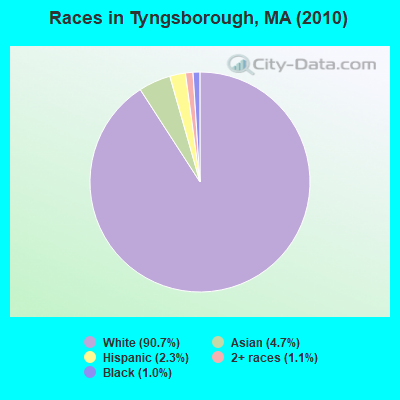
- 10,23790.7%White alone
- 5314.7%Asian alone
- 2652.3%Hispanic
- 1231.1%Two or more races
- 1181.0%Black alone
- 90.08%American Indian alone
- 90.08%Other race alone
Races in Tyngsborough detailed stats: ancestries, foreign born residents, place of birth
According to our research of Massachusetts and other state lists, there were 3 registered sex offenders living in Tyngsborough, Massachusetts as of April 23, 2024.
The ratio of all residents to sex offenders in Tyngsborough is 3,764 to 1.
The ratio of registered sex offenders to all residents in this city is much lower than the state average.
 Recent articles from our blog. Our writers, many of them Ph.D. graduates or candidates, create easy-to-read articles on a wide variety of topics.

Ancestries: Irish (30.8%), French (16.8%), English (15.6%), Italian (11.5%), French Canadian (10.1%), German (6.7%).
Current Local Time: EST time zone
Incorporated in 1809
Land area: 16.9 square miles.
Population density: 670 people per square mile (low).
536 residents are foreign born (1.8% Europe, 1.7% Asia).
| This town: | 4.8% |
| Massachusetts: | 12.2% |
| Tyngsborough town: | 1.6% ($3,191) |
| Massachusetts: | 1.3% ($2,336) |
Nearest city with pop. 50,000+: Lowell, MA  (5.7 miles , pop. 105,167).
Nearest city with pop. 200,000+: Boston, MA (29.4 miles , pop. 589,141).
Nearest city with pop. 1,000,000+: Bronx, NY (178.8 miles , pop. 1,332,650).
Nearest cities:
), ), Latitude: 42.67 N, Longitude: 71.42 W
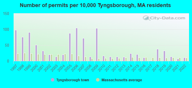
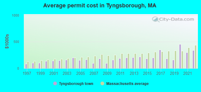
Single-family new house construction building permits:
- 2022: 12 buildings, average cost: $339,100
- 2021: 8 buildings, average cost: $298,000
- 2020: 15 buildings, average cost: $454,100
- 2019: 35 buildings, average cost: $161,600
- 2018: 42 buildings, average cost: $183,400
- 2017: 2 buildings, average cost: $350,000
- 2016: 12 buildings, average cost: $199,500
- 2015: 23 buildings, average cost: $187,000
- 2014: 27 buildings, average cost: $221,000
- 2013: 14 buildings, average cost: $205,800
- 2012: 15 buildings, average cost: $202,300
- 2011: 15 buildings, average cost: $190,600
- 2010: 19 buildings, average cost: $160,800
- 2009: 115 buildings, average cost: $96,700
- 2008: 16 buildings, average cost: $186,100
- 2007: 80 buildings, average cost: $98,800
- 2006: 116 buildings, average cost: $170,100
- 2005: 97 buildings, average cost: $154,700
- 2004: 22 buildings, average cost: $203,900
- 2003: 15 buildings, average cost: $159,900
- 2002: 22 buildings, average cost: $149,000
- 2001: 35 buildings, average cost: $142,200
- 2000: 56 buildings, average cost: $138,300
- 1999: 101 buildings, average cost: $104,300
- 1998: 84 buildings, average cost: $106,200
- 1997: 109 buildings, average cost: $85,500
| Here: | 3.0% |
| Massachusetts: | 3.5% |

- Health care (10.5%)
- Professional, scientific, technical services (9.8%)
- Computer & electronic products (9.1%)
- Construction (8.6%)
- Educational services (7.3%)
- Finance & insurance (4.6%)
- Accommodation & food services (4.6%)
- Construction (14.6%)
- Professional, scientific, technical services (11.7%)
- Computer & electronic products (6.2%)
- Public administration (5.2%)
- Accommodation & food services (4.4%)
- Broadcasting & telecommunications (4.0%)
- Educational services (3.6%)
- Health care (19.0%)
- Computer & electronic products (12.3%)
- Educational services (11.5%)
- Professional, scientific, technical services (7.6%)
- Finance & insurance (5.9%)
- Accommodation & food services (4.9%)
- Administrative & support & waste management services (4.0%)

- Other management occupations, except farmers and farm managers (6.1%)
- Computer specialists (4.9%)
- Other office and administrative support workers, including supervisors (4.2%)
- Other sales and related occupations, including supervisors (3.1%)
- Other production occupations, including supervisors (3.0%)
- Preschool, kindergarten, elementary, and middle school teachers (2.9%)
- Registered nurses (2.9%)
- Other management occupations, except farmers and farm managers (7.0%)
- Computer specialists (5.9%)
- Top executives (4.7%)
- Driver/sales workers and truck drivers (4.4%)
- Sales representatives, services, wholesale and manufacturing (4.3%)
- Other sales and related occupations, including supervisors (4.3%)
- Electrical equipment mechanics and other installation, maintenance, and repair workers, including supervisors (3.8%)

- Other office and administrative support workers, including supervisors (8.4%)
- Registered nurses (5.9%)
- Other management occupations, except farmers and farm managers (5.2%)
- Secretaries and administrative assistants (5.0%)
- Preschool, kindergarten, elementary, and middle school teachers (4.9%)
- Health technologists and technicians (4.0%)
- Other production occupations, including supervisors (3.9%)
Average climate in Tyngsborough, Massachusetts
Based on data reported by over 4,000 weather stations


(lower is better)
Air Quality Index (AQI) level in 2022 was 64.9. This is about average.
| City: | 64.9 |
| U.S.: | 72.6 |
Carbon Monoxide (CO) [ppm] level in 2022 was 0.157. This is significantly better than average. Closest monitor was 5.7 miles away from the city center.
| City: | 0.157 |
| U.S.: | 0.251 |
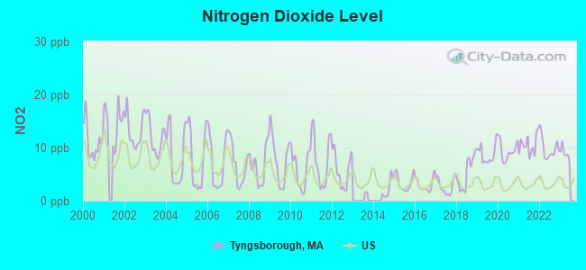
Nitrogen Dioxide (NO2) [ppb] level in 2022 was 9.85. This is significantly worse than average. Closest monitor was 5.6 miles away from the city center.
| City: | 9.85 |
| U.S.: | 5.11 |
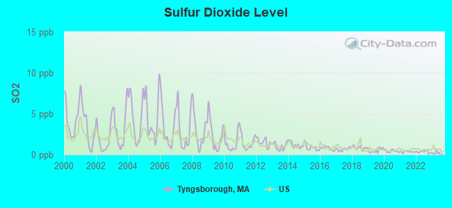
Sulfur Dioxide (SO2) [ppb] level in 2022 was 0.338. This is significantly better than average. Closest monitor was 2.5 miles away from the city center.
| City: | 0.338 |
| U.S.: | 1.515 |
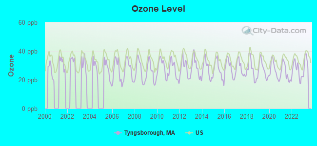
Ozone [ppb] level in 2022 was 26.5. This is better than average. Closest monitor was 2.5 miles away from the city center.
| City: | 26.5 |
| U.S.: | 33.3 |
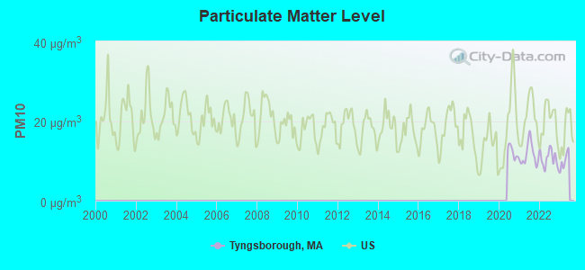
Particulate Matter (PM10) [µg/m3] level in 2022 was 10.6. This is significantly better than average. Closest monitor was 2.5 miles away from the city center.
| City: | 10.6 |
| U.S.: | 19.2 |
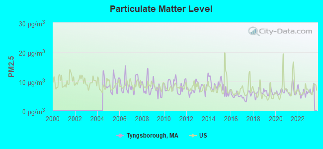
Particulate Matter (PM2.5) [µg/m3] level in 2022 was 6.20. This is better than average. Closest monitor was 2.5 miles away from the city center.
| City: | 6.20 |
| U.S.: | 8.11 |
Tornado activity:
Tyngsborough-area historical tornado activity is slightly above Massachusetts state average. It is 31% smaller than the overall U.S. average.
On 6/9/1953, a category F4 (max. wind speeds 207-260 mph) tornado 26.2 miles away from the Tyngsborough town center killed 90 people and injured 1228 people and caused between $50,000,000 and $500,000,000 in damages.
On 10/3/1970, a category F3 (max. wind speeds 158-206 mph) tornado 8.8 miles away from the town center killed one person and caused between $50,000 and $500,000 in damages.
Earthquake activity:
Tyngsborough-area historical earthquake activity is significantly above Massachusetts state average. It is 72% smaller than the overall U.S. average.On 4/20/2002 at 10:50:47, a magnitude 5.3 (5.3 ML, Depth: 3.0 mi, Class: Moderate, Intensity: VI - VII) earthquake occurred 171.0 miles away from the city center
On 10/7/1983 at 10:18:46, a magnitude 5.3 (5.1 MB, 5.3 LG, 5.1 ML) earthquake occurred 171.8 miles away from the city center
On 1/19/1982 at 00:14:42, a magnitude 4.7 (4.5 MB, 4.7 MD, 4.5 LG, Class: Light, Intensity: IV - V) earthquake occurred 58.0 miles away from the city center
On 4/20/2002 at 10:50:47, a magnitude 5.2 (5.2 MB, 4.2 MS, 5.2 MW, 5.0 MW) earthquake occurred 170.5 miles away from the city center
On 10/16/2012 at 23:12:25, a magnitude 4.7 (4.7 ML, Depth: 10.0 mi) earthquake occurred 74.7 miles away from Tyngsborough center
On 8/22/1992 at 12:20:32, a magnitude 4.8 (4.8 MB, 3.8 MS, 4.7 LG, Depth: 6.2 mi) earthquake occurred 253.2 miles away from the city center
Magnitude types: regional Lg-wave magnitude (LG), body-wave magnitude (MB), duration magnitude (MD), local magnitude (ML), surface-wave magnitude (MS), moment magnitude (MW)
Natural disasters:
The number of natural disasters in Middlesex County (31) is a lot greater than the US average (15).Major Disasters (Presidential) Declared: 17
Emergencies Declared: 14
Causes of natural disasters: Floods: 12, Storms: 9, Hurricanes: 6, Snowstorms: 6, Winter Storms: 5, Blizzards: 2, Snows: 2, Explosion: 1, Heavy Rain: 1, Snowfall: 1, Water Main Break: 1, Wind: 1 (Note: some incidents may be assigned to more than one category).
Hospitals and medical centers near Tyngsborough:
- PERSONAL TOUCH HOME AIDES (Home Health Center, about 3 miles away; N CHELMSFORD, MA)
- D'YOUVILLE TRANSITIONAL CARE, INC (Nursing Home, about 4 miles away; LOWELL, MA)
- NORTHWOOD CONV HME (Nursing Home, about 4 miles away; LOWELL, MA)
- RADIUS NORTHWOOD HEALTHCARE CENTER (Nursing Home, about 4 miles away; LOWELL, MA)
- D'YOUVILLE MANOR NURSING HOME (Nursing Home, about 4 miles away; LOWELL, MA)
- D'YOUVILLE SENIOR CARE (Nursing Home, about 4 miles away; LOWELL, MA)
- GLENWOOD CARE AND REHABILITATION CENTER (Nursing Home, about 4 miles away; LOWELL, MA)
Colleges/universities with over 2000 students nearest to Tyngsborough:
- University of Massachusetts-Lowell (about 5 miles; Lowell, MA; Full-time enrollment: 12,341)
- Middlesex Community College (about 13 miles; Bedford, MA; FT enrollment: 6,040)
- Merrimack College (about 15 miles; North Andover, MA; FT enrollment: 2,734)
- Fitchburg State University (about 20 miles; Fitchburg, MA; FT enrollment: 5,010)
- Northern Essex Community College (about 21 miles; Haverhill, MA; FT enrollment: 4,737)
- Mount Washington College (about 21 miles; Manchester, NH; FT enrollment: 2,187)
- Bentley University (about 22 miles; Waltham, MA; FT enrollment: 5,229)
Public high school in Tyngsborough:
Points of interest:
Notable locations in Tyngsborough: Immaculate Heart Camp (A), Uesper Country Club (B), Tyngsboro Sportsmens Club (C), Tyngsboro Country Club (D), Kiwanis Camp (E), Tyngsborough Business Park (F), Tynsborough Campground (G), Vesper Country Club (H), Westecch Industrial Park (I), Tyngsborough Fire Department Station 3 (J), Tyngsborough Fire Department Station 1 Headquarters (K), Tyngsborough Middle School Library (L), Tyngsborough Elementary School Library (M), Greater Lowell Technical High School Library (N), Tyngsborough Fire Department Station 2 (O), Littlefield Library (P), Tyngsborough Town Hall (Q), Boston University Metropolitan College Corporate Education Center Library (R). Display/hide their locations on the map
Churches in Tyngsborough include: Tyngsborough Evangelical Congregational Church (A), Saint Mary Magdalen Church (B), Massachusetts Baptist Temple (C), Church of Christ (D). Display/hide their locations on the map
Cemeteries: Sherburne Cemetery (1), Flint Cemetery (2), Gould Cemetery (3). Display/hide their locations on the map
Lakes, reservoirs, and swamps: Uptons Pond (A), Althea Lake (B), Flint Pond (C), Locust Pond (D), Mascuppic Lake (E), Upper Massapoag Pond (F), Upper Flint Pond (G), Tyngs Swamp (H). Display/hide their locations on the map
Streams, rivers, and creeks: Limit Brook (A), Bridge Meadow Brook (B), Lawrence Brook (C). Display/hide their locations on the map
Birthplace of: William Adams Richardson - Politician.
Drinking water stations with addresses in Tyngsborough and their reported violations in the past:
BENCHMARK CONDOMINIUMS (Address: C/O CENTURION PROPERTY MANAGEMENT , Population served: 180, Groundwater):Past health violations:COLONY HEIGHTS CONDOMINIUM (Population served: 120, Groundwater):Past monitoring violations:
- OCCT/SOWT Study/Recommendation - In MAR-01-2007, Contaminant: Lead and Copper Rule. Follow-up actions: St AO (w/o penalty) issued (OCT-01-2007), St Compliance achieved (JAN-08-2008), St AO (w/o penalty) issued (FEB-15-2008), St Compliance achieved (JAN-09-2009)
- Follow-up Or Routine LCR Tap M/R - In JAN-01-2013, Contaminant: Lead and Copper Rule
- Follow-up Or Routine LCR Tap M/R - In JUL-01-2007, Contaminant: Lead and Copper Rule. Follow-up actions: St AO (w/o penalty) issued (OCT-01-2007), St Compliance achieved (JAN-08-2008), St AO (w/o penalty) issued (FEB-15-2008), St Compliance achieved (JAN-09-2009)
- 13 regular monitoring violations
Past health violations:CURTIS HILL CONDOMINIUM (Population served: 96, Groundwater):Past monitoring violations:
- MCL, Monthly (TCR) - In JUL-2014, Contaminant: Coliform. Follow-up actions: St AO (w/o penalty) issued (JUL-10-2014)
- MCL, Monthly (TCR) - In SEP-2013, Contaminant: Coliform. Follow-up actions: St AO (w/o penalty) issued (OCT-02-2013)
- MCL, Monthly (TCR) - In AUG-2013, Contaminant: Coliform. Follow-up actions: St AO (w/o penalty) issued (SEP-20-2013)
- MCL, Monthly (TCR) - In JUL-2013, Contaminant: Coliform. Follow-up actions: St AO (w/o penalty) issued (AUG-01-2013)
- MCL, Monthly (TCR) - In SEP-2011, Contaminant: Coliform. Follow-up actions: St AO (w/o penalty) issued (OCT-21-2011)
- MCL, Monthly (TCR) - In JUL-2010, Contaminant: Coliform. Follow-up actions: St AO (w/o penalty) issued (AUG-23-2010)
- MCL, Monthly (TCR) - In NOV-2006, Contaminant: Coliform. Follow-up actions: St AO (w/o penalty) issued (JAN-04-2007)
- One minor monitoring violation
- 2 regular monitoring violations
Past monitoring violations:HAYSTACK ESTATES (Address: 164 WESTFORD RD., SUITE 16 , Population served: 60, Groundwater):
- 63 regular monitoring violations
Past health violations:THE GREENS (Population served: 25, Groundwater):Past monitoring violations:
- MCL, Average - Between OCT-2010 and DEC-2010, Contaminant: Combined Uranium. Follow-up actions: St AO (w/o penalty) issued (JAN-27-2011)
- Monitoring and Reporting (DBP) - Between OCT-2005 and DEC-2005, Contaminant: Chlorine. Follow-up actions: St AO (w/o penalty) issued (FEB-17-2006)
- Monitoring and Reporting (DBP) - Between JAN-2005 and DEC-2005, Contaminant: Total Haloacetic Acids (HAA5). Follow-up actions: St Compliance achieved (SEP-22-2005), St AO (w/o penalty) issued (FEB-17-2006)
- Monitoring and Reporting (DBP) - Between JAN-2005 and DEC-2005, Contaminant: TTHM. Follow-up actions: St Compliance achieved (SEP-22-2005), St AO (w/o penalty) issued (FEB-17-2006)
- 3 regular monitoring violations
Past monitoring violations:
- 15 regular monitoring violations
| This town: | 2.8 people |
| Massachusetts: | 2.5 people |
| This town: | 76.4% |
| Whole state: | 63.0% |
| This town: | 6.5% |
| Whole state: | 7.0% |
Likely homosexual households (counted as self-reported same-sex unmarried-partner households)
- Lesbian couples: 0.6% of all households
- Gay men: 0.2% of all households
| This town: | 4.7% |
| Whole state: | 9.3% |
| This town: | 2.0% |
| Whole state: | 4.4% |
8 people in homes for the physically handicapped in 2000
2 people in religious group quarters in 2000
Banks with branches in Tyngsborough (2011 data):
- TD Bank, National Association: Tyngsborough Branch at 1 Pondview Place, Middlesex Rd, branch established on 1984/12/17. Info updated 2010/10/04: Bank assets: $188,912.6 mil, Deposits: $153,149.8 mil, headquarters in Wilmington, DE, positive income, 1314 total offices, Holding Company: Toronto-Dominion Bank, The
- Washington Savings Bank: Tyngsborough Branch at 253 Middlesex Road, branch established on 1998/10/31. Info updated 2012/03/30: Bank assets: $181.8 mil, Deposits: $141.5 mil, headquarters in Lowell, MA, positive income, 3 total offices
For population 15 years and over in Tyngsborough:
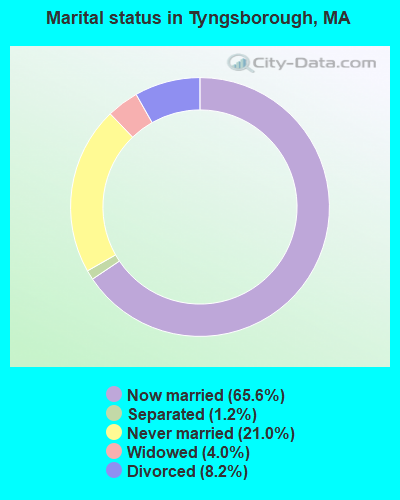
- Never married: 21.0%
- Now married: 65.6%
- Separated: 1.2%
- Widowed: 4.0%
- Divorced: 8.2%
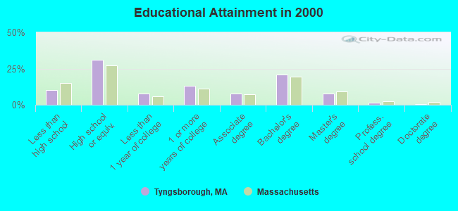
For population 25 years and over in Tyngsborough:
- High school or higher: 90.0%
- Bachelor's degree or higher: 30.6%
- Graduate or professional degree: 10.0%
- Unemployed: 3.2%
- Mean travel time to work (commute): 31.2 minutes
| Here: | 10.3 |
| Massachusetts average: | 13.1 |


Graphs represent county-level data. Detailed 2008 Election Results
Religion statistics for Tyngsborough, MA (based on Middlesex County data)


| Religion | Adherents | Congregations |
|---|---|---|
| Catholic | 718,209 | 107 |
| Mainline Protestant | 70,053 | 269 |
| Other | 68,480 | 199 |
| Evangelical Protestant | 41,270 | 304 |
| Orthodox | 23,641 | 28 |
| Black Protestant | 2,276 | 8 |
| None | 579,156 | - |
Food Environment Statistics:
| Middlesex County: | 1.71 / 10,000 pop. |
| Massachusetts: | 1.98 / 10,000 pop. |
| Middlesex County: | 0.03 / 10,000 pop. |
| State: | 0.05 / 10,000 pop. |
| This county: | 2.14 / 10,000 pop. |
| Massachusetts: | 2.22 / 10,000 pop. |
| Middlesex County: | 1.38 / 10,000 pop. |
| Massachusetts: | 1.77 / 10,000 pop. |
| This county: | 7.84 / 10,000 pop. |
| Massachusetts: | 8.76 / 10,000 pop. |
| This county: | 7.8% |
| Massachusetts: | 8.1% |
| Middlesex County: | 21.5% |
| State: | 22.5% |
| This county: | 18.0% |
| Massachusetts: | 16.5% |
6.91% of this county's 2021 resident taxpayers lived in other counties in 2020 ($102,955 average adjusted gross income)
| Here: | 6.91% |
| Massachusetts average: | 6.35% |
0.01% of residents moved from foreign countries ($137 average AGI)
Middlesex County: 0.01% Massachusetts average: 0.01%
Top counties from which taxpayers relocated into this county between 2020 and 2021:
| from Suffolk County, MA | |
| from Essex County, MA | |
| from Norfolk County, MA |
8.22% of this county's 2020 resident taxpayers moved to other counties in 2021 ($123,369 average adjusted gross income)
| Here: | 8.22% |
| Massachusetts average: | 7.18% |
0.01% of residents moved to foreign countries ($124 average AGI)
Middlesex County: 0.01% Massachusetts average: 0.02%
Top counties to which taxpayers relocated from this county between 2020 and 2021:
| to Suffolk County, MA | |
| to Essex County, MA | |
| to Worcester County, MA |
Strongest AM radio stations in Tyngsborough:
- WCAP (980 AM; 5 kW; LOWELL, MA; Owner: NORTHEAST RADIO, INC.)
- WRKO (680 AM; 50 kW; BOSTON, MA; Owner: ENTERCOM BOSTON LICENSE, LLC)
- WSMN (1590 AM; 5 kW; NASHUA, NH; Owner: 1590 BROADCASTING CORP.)
- WEEI (850 AM; 50 kW; BOSTON, MA; Owner: ENTERCOM BOSTON LICENSE, LLC)
- WWZN (1510 AM; 50 kW; BOSTON, MA; Owner: ROSE CITY RADIO CORPORATION)
- WKOX (1200 AM; 50 kW; FRAMINGHAM, MA; Owner: CAPSTAR TX LIMITED PARTNERSHIP)
- WBIX (1060 AM; 40 kW; NATICK, MA; Owner: LANGER BROADCASTING CORPORATION)
- WCEC (1110 AM; daytime; 5 kW; SALEM, NH; Owner: COSTA-EAGLE RADIO VENTURES LTD PARTNERSHIP)
- WCRN (830 AM; 50 kW; WORCESTER, MA; Owner: CARTER BROADCASTING CORPORATION)
- WRCA (1330 AM; 25 kW; WALTHAM, MA; Owner: WRCA LICENSE, LLC)
- WDER (1320 AM; 10 kW; DERRY, NH; Owner: BLOUNT COMMUNICATIONS, INC. OF NH)
- WBZ (1030 AM; 50 kW; BOSTON, MA; Owner: INFINITY BROADCASTING OPERATIONS, INC.)
- WAMG (890 AM; 25 kW; DEDHAM, MA; Owner: MEGA COMMUNICATIONS OF DEDHAM LICENSEE, LLC)
Strongest FM radio stations in Tyngsborough:
- WHOB (106.3 FM; NASHUA, NH; Owner: TELE-MEDIA COMPANY OF NEW HAMPSHIRE, L.L.C.)
- WKLB-FM (99.5 FM; LOWELL, MA; Owner: GREATER BOSTON RADIO, INC.)
- W227AM (93.3 FM; ANDOVER, MA; Owner: GREATER BOSTON RADIO, INC.)
- WJUL (91.5 FM; LOWELL, MA; Owner: UNIVERSITY OF MASSACHUSETTS, LOWELL)
- WFEX (92.1 FM; PETERBOROUGH, NH; Owner: FNX BROADCASTING OF NEW HAMPSHIRE LLC)
- WXRV (92.5 FM; HAVERHILL, MA; Owner: BEANPOT BROADCASTING CORP.)
- WGIR-FM (101.1 FM; MANCHESTER, NH; Owner: CAPSTAR TX LIMITED PARTNERSHIP)
- WBMX (98.5 FM; BOSTON, MA; Owner: INFINITY RADIO OPERATIONS INC.)
- WQLL (96.5 FM; BEDFORD, NH; Owner: SAGA COMMUNICATIONS OF NEW ENGLAND, LLC)
- WLMW (90.7 FM; MANCHESTER, NH; Owner: KNOWLEDGE FOR LIFE)
- WJMN (94.5 FM; BOSTON, MA; Owner: AMFM RADIO LICENSES, L.L.C.)
- WCRB (102.5 FM; WALTHAM, MA; Owner: CHARLES RIVER BROADCASTING WCRB LICE)
- WTKK (96.9 FM; BOSTON, MA; Owner: GREATER BOSTON RADIO, INC.)
- WROR-FM (105.7 FM; FRAMINGHAM, MA; Owner: GREATER BOSTON RADIO, INC.)
- WBOS (92.9 FM; BROOKLINE, MA; Owner: GREATER BOSTON RADIO, INC.)
- WXKS-FM (107.9 FM; MEDFORD, MA; Owner: AMFM RADIO LICENSES, L.L.C.)
- WZID (95.7 FM; MANCHESTER, NH; Owner: SAGA COMMUNICATIONS OF NEW ENGLAND, LLC)
- WMJX (106.7 FM; BOSTON, MA; Owner: GREATER BOSTON RADIO, INC.)
- WGBH (89.7 FM; BOSTON, MA; Owner: WGBH EDUCATIONAL FOUNDATION)
- WBUR-FM (90.9 FM; BOSTON, MA; Owner: TRUSTEES OF BOSTON UNIVERSITY)
TV broadcast stations around Tyngsborough:
- WNDS (Channel 50; DERRY, NH; Owner: CTV OF DERRY, INC)
- WFXZ-CA (Channel 24; BOSTON, MA; Owner: BOSTON BROADCASTING CORP.)
- WUTF (Channel 66; MARLBOROUGH, MA; Owner: TELEFUTURA BOSTON LLC)
- WCVB-TV (Channel 5; BOSTON, MA; Owner: WCVB HEARST-ARGYLE TV, INC.)
- WGBH-TV (Channel 2; BOSTON, MA; Owner: WGBH EDUCATIONAL FOUNDATION)
- WHDH-TV (Channel 7; BOSTON, MA; Owner: WHDH-TV)
- WMFP (Channel 62; LAWRENCE, MA; Owner: WSAH LICENSE, INC.)
- WBZ-TV (Channel 4; BOSTON, MA; Owner: VIACOM INC.)
- WGBX-TV (Channel 44; BOSTON, MA; Owner: WGBH EDUCATIONAL FOUNDATION)
- WUNI (Channel 27; WORCESTER, MA; Owner: ENTRAVISION HOLDINGS, LLC)
- WSBK-TV (Channel 38; BOSTON, MA; Owner: VIACOM INC.)
- WLVI-TV (Channel 56; CAMBRIDGE, MA; Owner: WLVI, INC.)
- WFXT (Channel 25; BOSTON, MA; Owner: FOX TELEVISION STATIONS INC.)
- WBPX (Channel 68; BOSTON, MA; Owner: PAXSON BOSTON-68 LICENSE, INC.)
- W40BO (Channel 40; BOSTON, MA; Owner: PAXSON COMMUNICATIONS LPTV, INC.)
- W33AK (Channel 33; NASHUA, NH; Owner: CENTER B/CING CORPORATION OF NEW HAMPSHIRE)
- WYCN-LP (Channel 13; NASHUA, NH; Owner: CENTER BROADCASTING CORP. OF NEW HAMPSHIRE)
- WTMU-LP (Channel 32; BOSTON, MA; Owner: ZGS BOSTON, INC.)
- WCEA-LP (Channel 58; BOSTON, MA; Owner: CHANNEL 19 TV CORPORATION)
- WHDN-LP (Channel 26; BOSTON, MA; Owner: GUENTER MARKSTEINER)
- National Bridge Inventory (NBI) Statistics
- 10Number of bridges
- 203ft / 62.1mTotal length
- $24,650,000Total costs
- 431,118Total average daily traffic
- 40,607Total average daily truck traffic
- 603,466Total future (year 2032) average daily traffic
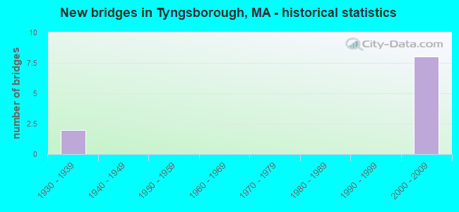
- New bridges - historical statistics
- 21930-1939
- 82000-2009
FCC Registered Antenna Towers:
12 (See the full list of FCC Registered Antenna Towers in Tyngsborough)FCC Registered Broadcast Land Mobile Towers:
6- 10 Kendall Rd (Lat: 42.675639 Lon: -71.423944), Call Sign: KYR950,
Assigned Frequencies: 482.387 MHz, Grant Date: 02/01/2012, Expiration Date: 02/04/2022, Cancellation Date: 04/09/2022, Certifier: Charles Chronopoulos, Registrant: Tyngsborough Police Department, 20 Westford Road, Tyngsboro, MA 01879, Phone: (978) 649-7504, Fax: (978) 649-2324, Email:
- 10 Kendall Rd (Lat: 42.675639 Lon: -71.423944), Call Sign: WBF974,
Assigned Frequencies: 485.512 MHz, 485.637 MHz, 485.687 MHz, Grant Date: 02/01/2012, Expiration Date: 02/04/2022, Cancellation Date: 04/09/2022, Certifier: Charles Chronopoulos, Registrant: Tyngsborough Police Department, 20 Westford Road, Tyngsboro, MA 01879, Phone: (978) 649-7504, Fax: (978) 649-2324, Email:
- Master Metering Station Pheasant Ln (Lat: 42.696667 Lon: -71.436667), Type: Pole, Structure height: 7.6 m, Overall height: 8.5 m, Call Sign: WPUR987,
Assigned Frequencies: 458.487 MHz, Grant Date: 01/28/2022, Expiration Date: 04/22/2032, Certifier: David Denommee, Registrant: Cyber Communications, Inc, 100 Fireworks Circle, Bridgewater, MA 02324, Phone: (508) 880-3294, Fax: (508) 880-6745, Email:
- Tyngsborough Well Fields (Lat: 42.695000 Lon: -71.421389), Type: Pole, Structure height: 12 m, Overall height: 13 m, Call Sign: WPXS304,
Assigned Frequencies: 452.562 MHz, Grant Date: 03/10/2023, Expiration Date: 06/02/2033, Certifier: Gary Mccarthy, Registrant: Tcs Communications Corp, Salisbury, MA 01952-5192, Phone: (978) 465-7932, Fax: (978) 462-8980, Email:
- Lat: 42.653944 Lon: -71.385972, Call Sign: WQVF729,
Assigned Frequencies: 72.1800 MHz, 72.2800 MHz, Grant Date: 01/28/2015, Expiration Date: 01/28/2025, Certifier: George Garabedian, Registrant: Primex Wireless Inc., 965 Wells St., Lake Geneva, WI 53147, Phone: (800) 537-0464
- Lat: 42.697028 Lon: -71.406861, Call Sign: WQWS366,
Assigned Frequencies: 456.562 MHz, 457.837 MHz, 457.662 MHz, 456.637 MHz, 457.687 MHz, Grant Date: 11/04/2015, Expiration Date: 11/04/2025, Certifier: Donald P Ciampa, Registrant: Washington Radio Reports, Gettysburg, PA 17325, Phone: (717) 334-0668, Fax: (717) 334-6440, Email:
FCC Registered Microwave Towers:
4- TYNGSBOROUGH, .2 Mi Sse Of Int Of Dunstable & Westford Rd (Lat: 42.650917 Lon: -71.430056), Type: Tower, Structure height: 54.9 m, Call Sign: WMS409,
Assigned Frequencies: 10755.0 MHz, 10582.5 MHz, Grant Date: 01/11/2011, Expiration Date: 02/01/2021, Cancellation Date: 02/04/2014, Registrant: Verizon Wireless, 1120 Sanctuary Pkwy, #150 Gasa5reg, Alpharetta, GA 30009-7630, Phone: (770) 797-1070, Fax: (770) 797-1036, Email:
- TYNGSBOROUGH, Lat: 42.586111 Lon: -71.547222, Call Sign: WPXY705, Licensee ID: L00479745,
Assigned Frequencies: 956.443 MHz, Grant Date: 06/28/2023, Expiration Date: 07/02/2033, Certifier: David E Denommee, Registrant: Tyngsborough Water District
- Tower Road Site, 15 Tower Road (Lat: 42.651000 Lon: -71.429944), Type: Ltower, Structure height: 51.8 m, Overall height: 54.9 m, Call Sign: WRXP932,
Assigned Frequencies: 19455.0 MHz, 19495.0 MHz, Grant Date: 06/07/2023, Expiration Date: 06/07/2033, Certifier: Richard D Howe, Registrant: Micronet Communications, Inc., 812 Lexington Dr, Plano, TX 75075, Phone: (972) 422-7200, Email:
- Police HQ, 20 Westford Road (Lat: 42.669667 Lon: -71.420361), Type: Gtower, Structure height: 30.5 m, Overall height: 33.5 m, Call Sign: WRXP936,
Assigned Frequencies: 17935.0 MHz, Grant Date: 06/07/2023, Expiration Date: 06/07/2033, Certifier: Richard D Howe, Registrant: Micronet Communications, Inc., 812 Lexington Dr, Plano, TX 75075, Phone: (972) 422-7200, Email:
FCC Registered Amateur Radio Licenses:
12 (See the full list of FCC Registered Amateur Radio Licenses in Tyngsborough)2002 - 2018 National Fire Incident Reporting System (NFIRS) incidents
- Fire incident types reported to NFIRS in Tyngsborough, MA
- 21443.4%Outside Fires
- 13828.0%Structure Fires
- 11122.5%Mobile Property/Vehicle Fires
- 306.1%Other
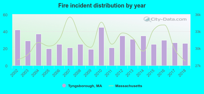 According to the data from the years 2002 - 2018 the average number of fires per year is 29. The highest number of reported fires - 45 took place in 2010, and the least - 19 in 2009. The data has a dropping trend.
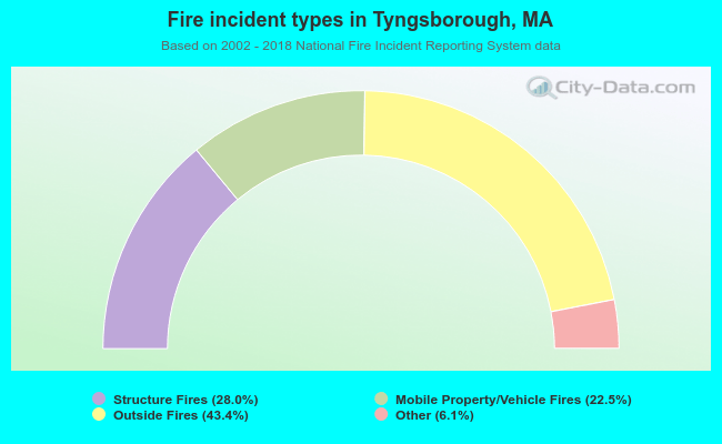 When looking into fire subcategories, the most incidents belonged to: Outside Fires (43.4%), and Structure Fires (28.0%).
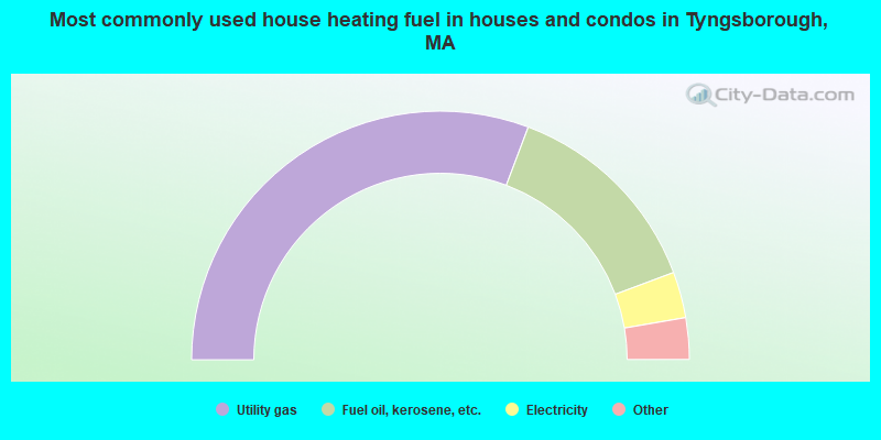
- 61.5%Utility gas
- 27.1%Fuel oil, kerosene, etc.
- 6.0%Electricity
- 3.5%Bottled, tank, or LP gas
- 1.4%Wood
- 0.3%No fuel used
- 0.3%Other fuel
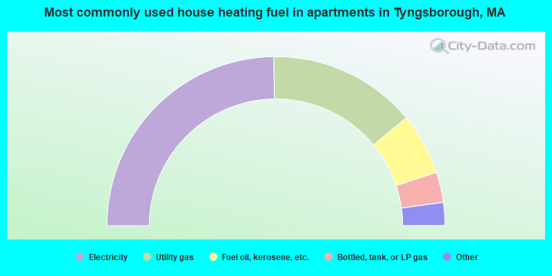
- 49.6%Electricity
- 28.4%Utility gas
- 11.8%Fuel oil, kerosene, etc.
- 5.8%Bottled, tank, or LP gas
- 2.9%No fuel used
- 1.5%Other fuel
Tyngsborough compared to Massachusetts state average:
- Unemployed percentage significantly below state average.
- Black race population percentage significantly below state average.
- Hispanic race population percentage significantly below state average.
- Foreign-born population percentage significantly below state average.
- Renting percentage significantly below state average.
- Length of stay since moving in significantly above state average.
- Number of rooms per house significantly below state average.
- House age significantly below state average.
Tyngsborough on our top lists:
- #3 on the list of "Top 101 cities with largest percentage of females in industries: computer and electronic products (population 5,000+)"
- #20 on the list of "Top 101 cities with largest percentage of females in occupations: engineers (population 5,000+)"
- #20 on the list of "Top 101 cities with largest percentage of males in industries: electrical and electronic goods merchant wholesalers (population 5,000+)"
- #22 on the list of "Top 101 cities with largest percentage of females in occupations: drafters, engineering, and mapping technicians (population 5,000+)"
- #25 on the list of "Top 101 cities with largest percentage of females in occupations: special education teachers (population 5,000+)"
- #39 on the list of "Top 101 cities with largest percentage of males in industries: broadcasting and telecommunications (population 5,000+)"
- #40 on the list of "Top 101 cities with largest percentage of females in occupations: financial managers (population 5,000+)"
- #58 on the list of "Top 101 cities with largest percentage of males in occupations: printing workers (population 5,000+)"
- #62 on the list of "Top 101 cities with largest percentage of females in occupations: computer specialists (population 5,000+)"
- #68 on the list of "Top 101 cities with largest percentage of females in industries: radio, tv, and computer stores (population 5,000+)"
- #78 on the list of "Top 101 cities with largest percentage of males in industries: music stores (population 5,000+)"
- #93 on the list of "Top 101 cities with largest percentage of males in industries: leather and allied products (population 5,000+)"
- #96 on the list of "Top 101 cities with largest percentage of males in industries: computer and electronic products (population 5,000+)"
- #100 on the list of "Top 101 cities with largest percentage of females in industries: office supplies and stationery stores (population 5,000+)"
- #101 on the list of "Top 101 cities with largest percentage of females in industries: printing and related support activities (population 5,000+)"
- #68 (01879) on the list of "Top 101 zip codes with the largest percentage of Greek first ancestries (pop 5,000+)"
- #4 on the list of "Top 101 counties with the most Orthodox adherents"
- #7 on the list of "Top 101 counties with the most Catholic adherents"
- #7 on the list of "Top 101 counties with the most Mainline Protestant congregations"
- #7 on the list of "Top 101 counties with the most Orthodox congregations"
- #8 on the list of "Top 101 counties with the lowest percentage of residents that keep firearms around their homes"

|
|
Total of 88 patent applications in 2008-2024.