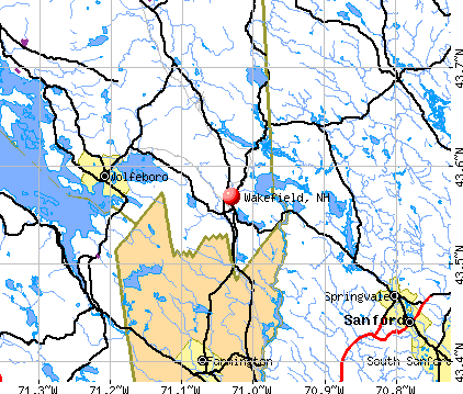
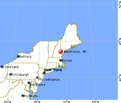
Wakefield, New Hampshire

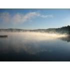
Wakefield: Province Lake sunset
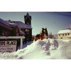
Wakefield: Sanbornville United Methodist Church, 173 Meadow SAt., Sanbornville, NH 03872
Wakefield: Province Lake in the fall
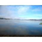
Wakefield: Province Lake
- add
your


Submit your own pictures of this town and show them to the world
- OSM Map
- General Map
- Google Map
- MSN Map
Population change since 2000: +19.4%
 |
| Males: 2,519 | |
| Females: 2,559 |
| Median resident age: | 45.9 years |
| New Hampshire median age: | 43.9 years |
Zip codes: 03830.
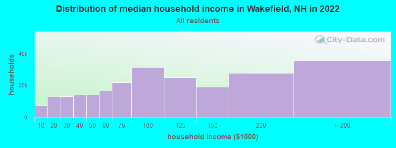
| Wakefield: | $81,116 |
| NH: | $89,992 |
Estimated per capita income in 2022: $48,277 (it was $21,507 in 2000)
Wakefield town income, earnings, and wages data
Estimated median house or condo value in 2022: $330,717 (it was $108,100 in 2000)
| Wakefield: | $330,717 |
| NH: | $384,700 |
Mean prices in 2022: all housing units: $505,201; detached houses: $542,950; townhouses or other attached units: $363,532; in 2-unit structures: $373,773; in 3-to-4-unit structures: $587,160; in 5-or-more-unit structures: $313,992; mobile homes: $113,714; occupied boats, rvs, vans, etc.: $118,400
Detailed information about poverty and poor residents in Wakefield, NH


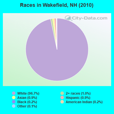
- 4,91096.7%White alone
- 501.0%Two or more races
- 480.9%Asian alone
- 450.9%Hispanic
- 90.2%Black alone
- 90.2%American Indian alone
- 60.1%Other race alone
- 10.02%Native Hawaiian and Other
Pacific Islander alone
Races in Wakefield detailed stats: ancestries, foreign born residents, place of birth
According to our research of New Hampshire and other state lists, there were 10 registered sex offenders living in Wakefield, New Hampshire as of April 23, 2024.
The ratio of all residents to sex offenders in Wakefield is 508 to 1.
The ratio of registered sex offenders to all residents in this city is near the state average.
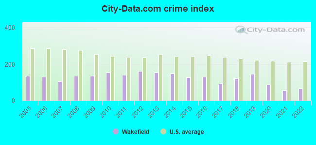
Type |
2009 |
2010 |
2011 |
2012 |
2013 |
2014 |
2015 |
2016 |
2017 |
2018 |
2019 |
2020 |
2021 |
2022 |
|---|---|---|---|---|---|---|---|---|---|---|---|---|---|---|
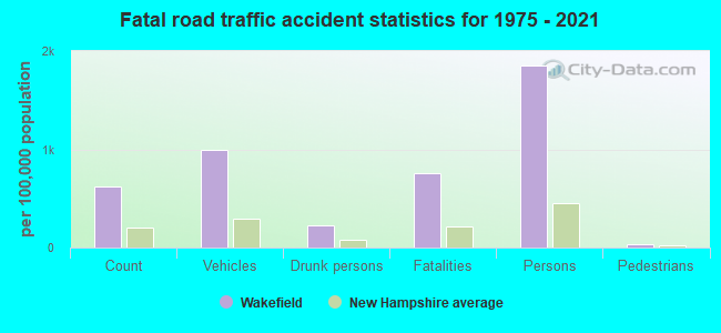
| Murders (per 100,000) | 0 (0.0) | 0 (0.0) | 0 (0.0) | 0 (0.0) | 0 (0.0) | 0 (0.0) | 0 (0.0) | 0 (0.0) | 0 (0.0) | 0 (0.0) | 0 (0.0) | 0 (0.0) | 0 (0.0) | 0 (0.0) |
| Rapes (per 100,000) | 0 (0.0) | 2 (34.5) | 0 (0.0) | 1 (19.7) | 3 (59.8) | 2 (40.0) | 2 (35.4) | 2 (35.5) | 1 (17.8) | 4 (70.1) | 7 (120.9) | 2 (34.5) | 0 (0.0) | 1 (15.8) |
| Robberies (per 100,000) | 2 (36.5) | 0 (0.0) | 0 (0.0) | 1 (19.7) | 0 (0.0) | 0 (0.0) | 0 (0.0) | 2 (35.5) | 0 (0.0) | 0 (0.0) | 0 (0.0) | 0 (0.0) | 0 (0.0) | 0 (0.0) |
| Assaults (per 100,000) | 4 (72.9) | 5 (86.4) | 8 (138.0) | 3 (59.2) | 2 (39.9) | 7 (140.1) | 8 (141.6) | 7 (124.4) | 6 (106.9) | 6 (105.1) | 6 (103.6) | 5 (86.2) | 3 (51.6) | 9 (142.5) |
| Burglaries (per 100,000) | 24 (437.6) | 25 (431.8) | 39 (672.6) | 41 (809.0) | 34 (677.6) | 26 (520.3) | 27 (477.8) | 19 (337.5) | 18 (320.7) | 8 (140.2) | 7 (120.9) | 17 (293.2) | 7 (120.4) | 4 (63.3) |
| Thefts (per 100,000) | 83 (1,513) | 93 (1,606) | 83 (1,432) | 68 (1,342) | 59 (1,176) | 56 (1,121) | 48 (849.4) | 50 (888.3) | 40 (712.6) | 39 (683.3) | 24 (414.6) | 26 (448.4) | 46 (791.5) | 28 (443.4) |
| Auto thefts (per 100,000) | 13 (237.0) | 10 (172.7) | 7 (120.7) | 12 (236.8) | 3 (59.8) | 5 (100.1) | 3 (53.1) | 4 (71.1) | 4 (71.3) | 5 (87.6) | 3 (51.8) | 3 (51.7) | 5 (86.0) | 2 (31.7) |
| Arson (per 100,000) | 1 (18.2) | 0 (0.0) | 1 (17.2) | 1 (19.7) | 0 (0.0) | 0 (0.0) | 2 (35.4) | 0 (0.0) | 1 (17.8) | 0 (0.0) | 1 (17.3) | 0 (0.0) | 1 (17.2) | 0 (0.0) |
| City-Data.com crime index | 135.6 | 153.2 | 141.6 | 162.8 | 155.0 | 149.3 | 128.3 | 128.8 | 92.3 | 121.2 | 146.7 | 87.4 | 57.3 | 65.9 |
The City-Data.com crime index weighs serious crimes and violent crimes more heavily. Higher means more crime, U.S. average is 246.1. It adjusts for the number of visitors and daily workers commuting into cities.
Crime rate in Wakefield detailed stats: murders, rapes, robberies, assaults, burglaries, thefts, arson
Full-time law enforcement employees in 2021, including police officers: 13 (11 officers - 11 male; 0 female).
| Officers per 1,000 residents here: | 1.89 |
| New Hampshire average: | 2.14 |
 Recent articles from our blog. Our writers, many of them Ph.D. graduates or candidates, create easy-to-read articles on a wide variety of topics.


 | Move to NH - Suggested Areas & Towns? (108 replies) |
| New Hampshire is on my short list of locations to move to from Montana (42 replies) |
| Wakefield and Wentworth (7 replies) |
| Moving from Va to NH looking for some advice :) (32 replies) |
| Drinking Water issues in Southern New Hampshire (16 replies) |
| Which of these towns do you think would check our boxes?? (19 replies) |
Latest news from Wakefield, NH collected exclusively by city-data.com from local newspapers, TV, and radio stations
Ancestries: English (21.7%), Irish (18.7%), French (13.2%), United States (11.6%), Italian (6.6%), German (5.8%).
Current Local Time: EST time zone
Incorporated in 1774
Elevation: 681 feet
Land area: 39.3 square miles.
Population density: 129 people per square mile (very low).
95 residents are foreign born (0.9% Europe, 0.7% Asia, 0.5% North America).
| This town: | 2.2% |
| New Hampshire: | 4.4% |
| Wakefield town: | 1.4% ($1,469) |
| New Hampshire: | 2.3% ($2,946) |
Nearest city with pop. 50,000+: Portland, ME  (37.3 miles , pop. 64,249).
Nearest city with pop. 200,000+: Boston, MA (88.4 miles , pop. 589,141).
Nearest city with pop. 1,000,000+: Bronx, NY (240.3 miles , pop. 1,332,650).
Nearest cities:
), ), ), ), ), ), ), )Latitude: 43.60 N, Longitude: 71.01 W
Area code commonly used in this area: 603

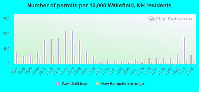
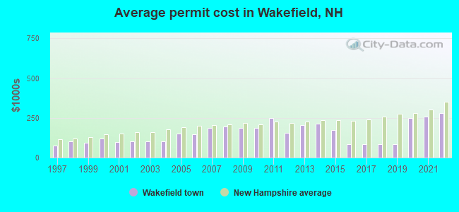
Single-family new house construction building permits:
- 2022: 27 buildings, average cost: $279,200
- 2021: 77 buildings, average cost: $259,200
- 2020: 29 buildings, average cost: $249,800
- 2019: 17 buildings, average cost: $85,100
- 2018: 17 buildings, average cost: $85,100
- 2017: 16 buildings, average cost: $85,100
- 2016: 16 buildings, average cost: $85,100
- 2015: 7 buildings, average cost: $172,600
- 2014: 15 buildings, average cost: $213,100
- 2013: 5 buildings, average cost: $206,000
- 2012: 5 buildings, average cost: $155,200
- 2011: 9 buildings, average cost: $248,800
- 2010: 11 buildings, average cost: $187,500
- 2009: 6 buildings, average cost: $186,200
- 2008: 22 buildings, average cost: $195,000
- 2007: 37 buildings, average cost: $189,400
- 2006: 65 buildings, average cost: $146,700
- 2005: 94 buildings, average cost: $150,200
- 2004: 93 buildings, average cost: $101,100
- 2003: 73 buildings, average cost: $100,900
- 2002: 72 buildings, average cost: $101,700
- 2001: 68 buildings, average cost: $95,900
- 2000: 37 buildings, average cost: $120,600
- 1999: 29 buildings, average cost: $93,900
- 1998: 23 buildings, average cost: $100,900
- 1997: 30 buildings, average cost: $76,600
| Here: | 3.1% |
| New Hampshire: | 2.5% |
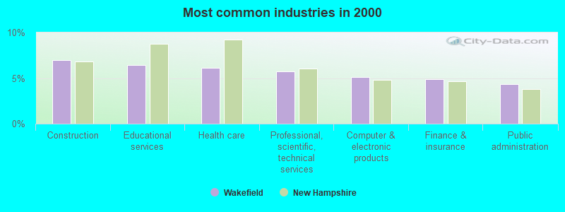
- Construction (7.0%)
- Educational services (6.5%)
- Health care (6.1%)
- Professional, scientific, technical services (5.7%)
- Computer & electronic products (5.1%)
- Finance & insurance (4.9%)
- Public administration (4.4%)
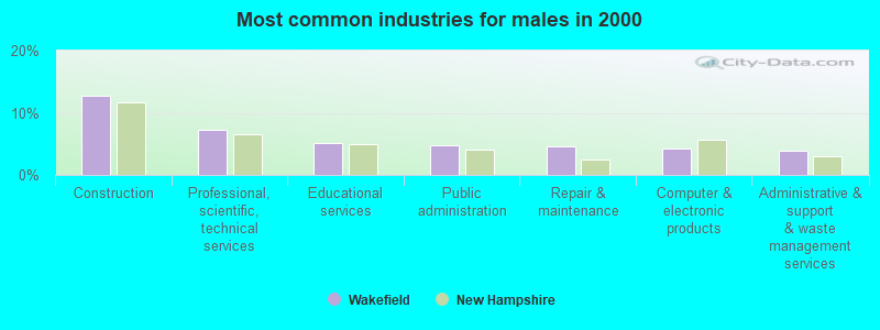
- Construction (12.7%)
- Professional, scientific, technical services (7.2%)
- Educational services (5.1%)
- Public administration (4.8%)
- Repair & maintenance (4.7%)
- Computer & electronic products (4.3%)
- Administrative & support & waste management services (3.8%)
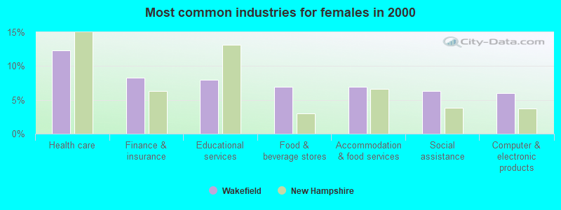
- Health care (12.3%)
- Finance & insurance (8.2%)
- Educational services (8.0%)
- Food & beverage stores (7.0%)
- Accommodation & food services (7.0%)
- Social assistance (6.3%)
- Computer & electronic products (6.0%)
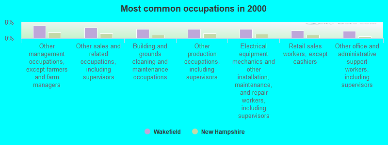
- Other management occupations, except farmers and farm managers (6.4%)
- Other sales and related occupations, including supervisors (5.3%)
- Building and grounds cleaning and maintenance occupations (4.6%)
- Other production occupations, including supervisors (4.6%)
- Electrical equipment mechanics and other installation, maintenance, and repair workers, including supervisors (4.5%)
- Retail sales workers, except cashiers (3.8%)
- Other office and administrative support workers, including supervisors (3.6%)
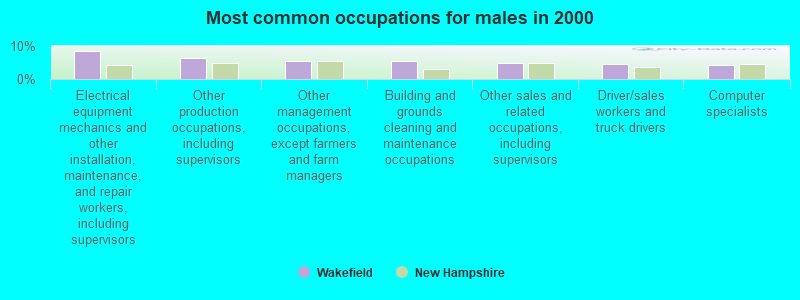
- Electrical equipment mechanics and other installation, maintenance, and repair workers, including supervisors (8.4%)
- Other production occupations, including supervisors (6.3%)
- Other management occupations, except farmers and farm managers (5.5%)
- Building and grounds cleaning and maintenance occupations (5.5%)
- Other sales and related occupations, including supervisors (4.8%)
- Driver/sales workers and truck drivers (4.5%)
- Computer specialists (4.4%)
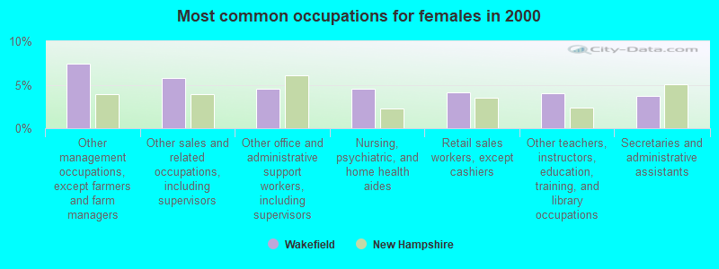
- Other management occupations, except farmers and farm managers (7.4%)
- Other sales and related occupations, including supervisors (5.8%)
- Other office and administrative support workers, including supervisors (4.5%)
- Nursing, psychiatric, and home health aides (4.5%)
- Retail sales workers, except cashiers (4.1%)
- Other teachers, instructors, education, training, and library occupations (4.0%)
- Secretaries and administrative assistants (3.7%)
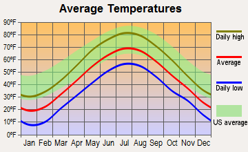
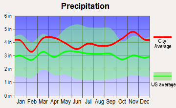
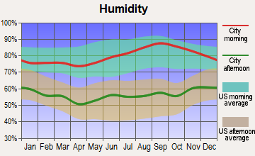
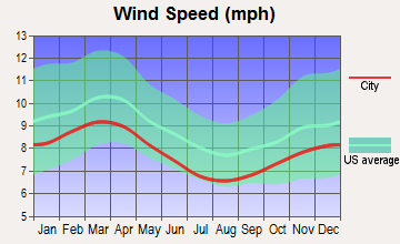
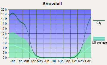
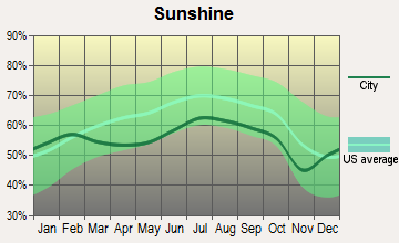
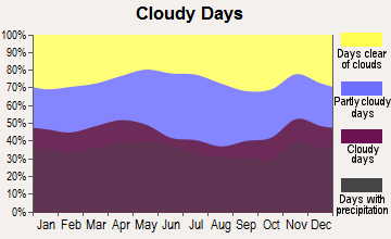
Average climate in Wakefield, New Hampshire
Based on data reported by over 4,000 weather stations
(lower is better)
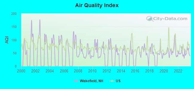
Air Quality Index (AQI) level in 2023 was 52.0. This is better than average.
| City: | 52.0 |
| U.S.: | 72.6 |
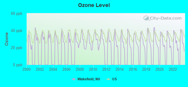
Ozone [ppb] level in 2023 was 29.8. This is about average. Closest monitor was 6.6 miles away from the city center.
| City: | 29.8 |
| U.S.: | 33.3 |
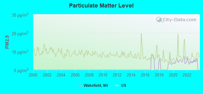
Particulate Matter (PM2.5) [µg/m3] level in 2022 was 4.52. This is significantly better than average. Closest monitor was 20.6 miles away from the city center.
| City: | 4.52 |
| U.S.: | 8.11 |
Tornado activity:
Wakefield-area historical tornado activity is slightly below New Hampshire state average. It is 66% smaller than the overall U.S. average.
On 7/18/1963, a category F2 (max. wind speeds 113-157 mph) tornado 9.6 miles away from the Wakefield town center caused between $5000 and $50,000 in damages.
On 6/22/1981, a category F2 tornado 14.2 miles away from the town center caused between $500,000 and $5,000,000 in damages.
Earthquake activity:
Wakefield-area historical earthquake activity is significantly above New Hampshire state average. It is 73% smaller than the overall U.S. average.On 4/20/2002 at 10:50:47, a magnitude 5.3 (5.3 ML, Depth: 3.0 mi, Class: Moderate, Intensity: VI - VII) earthquake occurred 147.9 miles away from the city center
On 10/16/2012 at 23:12:25, a magnitude 4.7 (4.7 ML, Depth: 10.0 mi, Class: Light, Intensity: IV - V) earthquake occurred 17.7 miles away from the city center
On 1/19/1982 at 00:14:42, a magnitude 4.7 (4.5 MB, 4.7 MD, 4.5 LG) earthquake occurred 30.4 miles away from the city center
On 10/7/1983 at 10:18:46, a magnitude 5.3 (5.1 MB, 5.3 LG, 5.1 ML) earthquake occurred 168.3 miles away from Wakefield center
On 4/20/2002 at 10:50:47, a magnitude 5.2 (5.2 MB, 4.2 MS, 5.2 MW, 5.0 MW) earthquake occurred 148.1 miles away from Wakefield center
On 8/21/1996 at 07:54:14, a magnitude 3.8 (3.8 LG, 3.6 LG, Depth: 6.2 mi, Class: Light, Intensity: II - III) earthquake occurred 44.0 miles away from the city center
Magnitude types: regional Lg-wave magnitude (LG), body-wave magnitude (MB), duration magnitude (MD), local magnitude (ML), surface-wave magnitude (MS), moment magnitude (MW)
Natural disasters:
The number of natural disasters in Carroll County (29) is a lot greater than the US average (15).Major Disasters (Presidential) Declared: 17
Emergencies Declared: 9
Causes of natural disasters: Storms: 12, Floods: 11, Winter Storms: 5, Hurricanes: 4, Snows: 4, Snowstorms: 2, Blizzard: 1, Heavy Rain: 1, Ice Storm: 1, Snowfall: 1, Tornado: 1, Tropical Storm: 1, Wind: 1, Other: 1 (Note: some incidents may be assigned to more than one category).
Hospitals and medical centers near Wakefield:
- MOUNTAIN VIEW NURSING HOME (Nursing Home, about 9 miles away; OSSIPEE, NH)
- HUGGINS HOSPITAL Critical Access Hospitals (about 10 miles away; WOLFEBORO, NH)
- VNA HOSPICE OF S CARROLL CO AND VICINITY (Hospital, about 10 miles away; WOLFEBORO, NH)
- WOLFEBORO BAY CARE AND REHABILITATION CENTER (Nursing Home, about 11 miles away; WOLFEBORO, NH)
Colleges/universities with over 2000 students nearest to Wakefield:
- Saint Joseph's College of Maine (about 31 miles; Standish, ME; Full-time enrollment: 2,010)
- University of New Hampshire-Main Campus (about 33 miles; Durham, NH; FT enrollment: 15,243)
- University of New England (about 33 miles; Biddeford, ME; FT enrollment: 4,539)
- Plymouth State University (about 36 miles; Plymouth, NH; FT enrollment: 4,838)
- NHTI-Concord's Community College (about 37 miles; Concord, NH; FT enrollment: 2,865)
- University of Southern Maine (about 37 miles; Portland, ME; FT enrollment: 6,647)
- Southern Maine Community College (about 40 miles; South Portland, ME; FT enrollment: 4,666)
Points of interest:
Notable locations in Wakefield: Province Lake (A), McCutcheon Corners (B), Bally-Hoo Campground (C), Wakefield Fire and Rescue Station 1 (D), Wakefield Fire and Rescue Station 3 (E), Wakefield Fire Rescue Station 2 (F), Gafney Library (G), Wakefield Town Hall (H), Greater Wakefield Chamber of Commerce (I), Lovell Lake Boathouse (J). Display/hide their locations on the map
Churches in Wakefield include: Wakefield Congregational Church (A), Spinney Church (B), Church of Saint John the Baptist Episcopal Church (C), Saint Anthonys Church (D). Display/hide their locations on the map
Lakes and reservoirs: Horn Pond (A), Province Lake (B), Stump Pond (C), Balch Pond (D), Union Meadows Pond (E), Lake Ivanhoe (F), Province Lake (G), Sand Pond (H). Display/hide their locations on the map
Streams, rivers, and creeks: Scribner Brook (A), Pike Brook (B), Horse Brook (C). Display/hide their locations on the map
Park in Wakefield: Wakefield Village Historic District (1). Display/hide its location on the map
Beaches: Lovell Lake Beach (A), Providence Lake Beach (B), Great East Lake Beach (C), Lake Ivanhoe Beach (D). Display/hide their locations on the map
Hotel: Wakefield Inn (2723 Wakefield Road) (1). Display/hide its approximate location on the map
Drinking water stations with addresses in Wakefield and their reported violations in the past:
WONTONS CHINESE RESTAURANT (Population served: 59, Groundwater):Past monitoring violations:WAKEFIELD INN AND RESTAURANT (Population served: 50, Groundwater):
- Monitoring, Source Water (GWR) - Between AUG-07-2013 and SEP-07-2013, Contaminant: E. COLI. Follow-up actions: St Public Notif requested (SEP-30-2013), St Violation/Reminder Notice (SEP-30-2013), St Compliance achieved (SEP-30-2013), St Public Notif received (OCT-30-2013)
- Monitoring, Repeat Major (TCR) - Between JUL-2013 and SEP-2013, Contaminant: Coliform (TCR). Follow-up actions: St Public Notif requested (SEP-30-2013), St Violation/Reminder Notice (SEP-30-2013), St Compliance achieved (SEP-30-2013), St Public Notif received (OCT-30-2013)
- 4 routine major monitoring violations
Past monitoring violations:
- One routine major monitoring violation
| This town: | 2.4 people |
| New Hampshire: | 2.5 people |
| This town: | 70.7% |
| Whole state: | 66.3% |
| This town: | 8.7% |
| Whole state: | 8.3% |
Likely homosexual households (counted as self-reported same-sex unmarried-partner households)
- Lesbian couples: 0.3% of all households
- Gay men: 0.3% of all households
| This town: | 7.1% |
| Whole state: | 6.5% |
| This town: | 2.6% |
| Whole state: | 2.8% |
For population 15 years and over in Wakefield:
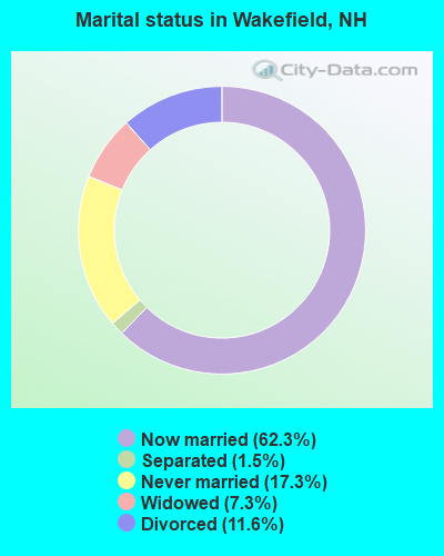
- Never married: 17.3%
- Now married: 62.3%
- Separated: 1.5%
- Widowed: 7.3%
- Divorced: 11.6%
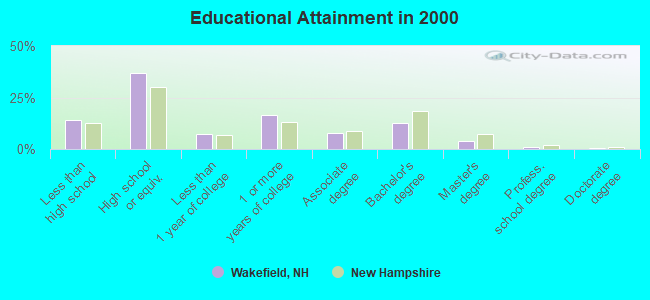
For population 25 years and over in Wakefield:
- High school or higher: 85.9%
- Bachelor's degree or higher: 17.5%
- Graduate or professional degree: 5.0%
- Unemployed: 4.3%
- Mean travel time to work (commute): 38.7 minutes
| Here: | 9.0 |
| New Hampshire average: | 10.9 |
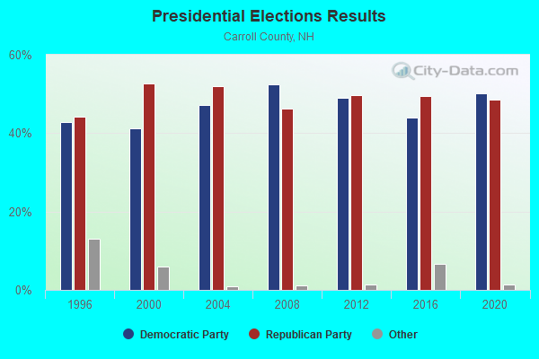
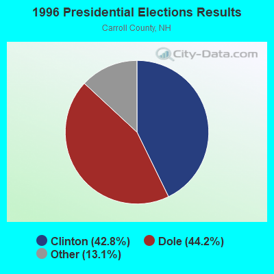
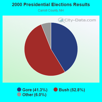

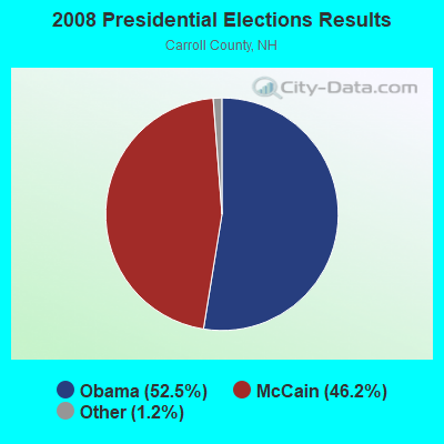
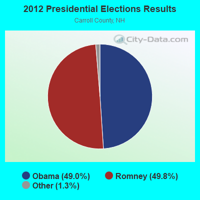
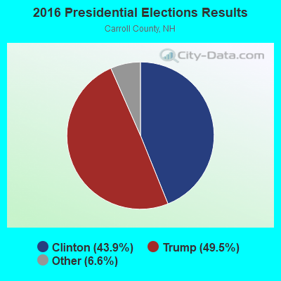
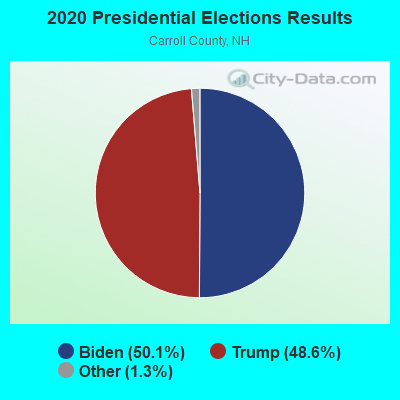
Graphs represent county-level data. Detailed 2008 Election Results
Religion statistics for Wakefield, NH (based on Carroll County data)
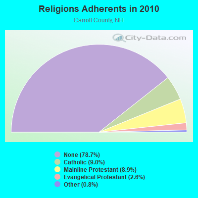
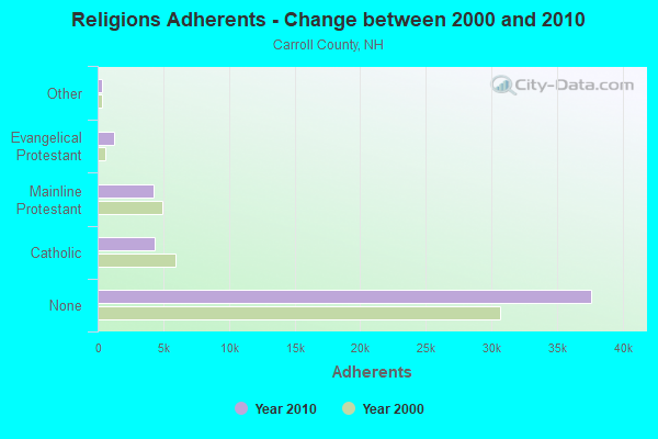
| Religion | Adherents | Congregations |
|---|---|---|
| Catholic | 4,304 | 2 |
| Mainline Protestant | 4,266 | 30 |
| Evangelical Protestant | 1,241 | 14 |
| Other | 366 | 5 |
| None | 37,641 | - |
Food Environment Statistics:
| This county: | 4.23 / 10,000 pop. |
| State: | 2.14 / 10,000 pop. |
| Carroll County: | 2.54 / 10,000 pop. |
| New Hampshire: | 1.78 / 10,000 pop. |
| Here: | 8.47 / 10,000 pop. |
| State: | 4.02 / 10,000 pop. |
| This county: | 24.13 / 10,000 pop. |
| State: | 9.70 / 10,000 pop. |
| Carroll County: | 8.8% |
| New Hampshire: | 7.6% |
| Carroll County: | 21.2% |
| New Hampshire: | 24.4% |
| Carroll County: | 16.9% |
| New Hampshire: | 15.9% |
Strongest AM radio stations in Wakefield:
- WASR (1420 AM; 5 kW; WOLFEBORO, NH; Owner: RADIO WOLFEBORO, INC.)
- WGIN (930 AM; 10 kW; ROCHESTER, NH; Owner: CAPSTAR TX LIMITED PARTNERSHIP)
- WMTW (870 AM; 10 kW; GORHAM, ME; Owner: RADIO PARTNERS OF MAINE, L.P.)
- WRKO (680 AM; 50 kW; BOSTON, MA; Owner: ENTERCOM BOSTON LICENSE, LLC)
- WEEI (850 AM; 50 kW; BOSTON, MA; Owner: ENTERCOM BOSTON LICENSE, LLC)
- WGAN (560 AM; 5 kW; PORTLAND, ME; Owner: SAGA COMMUNICATIONS OF NEW ENGLAND, LLC)
- WBZ (1030 AM; 50 kW; BOSTON, MA; Owner: INFINITY BROADCASTING OPERATIONS, INC.)
- WEZS (1350 AM; 5 kW; LACONIA, NH; Owner: GARY W. HAMMOND)
- WCRN (830 AM; 50 kW; WORCESTER, MA; Owner: CARTER BROADCASTING CORPORATION)
- WKOX (1200 AM; 50 kW; FRAMINGHAM, MA; Owner: CAPSTAR TX LIMITED PARTNERSHIP)
- WWZN (1510 AM; 50 kW; BOSTON, MA; Owner: ROSE CITY RADIO CORPORATION)
- WTSN (1270 AM; 5 kW; DOVER, NH; Owner: GARRISON CITY BROADCASTING, INC.)
- WBIX (1060 AM; 40 kW; NATICK, MA; Owner: LANGER BROADCASTING CORPORATION)
Strongest FM radio stations in Wakefield:
- WSCY (106.9 FM; MOULTONBOROUGH, NH; Owner: NORTHEAST COMMUNICATIONS CORPORATION)
- WMEA (90.1 FM; PORTLAND, ME; Owner: MAINE PUBLIC BROADCASTING CORPORATION)
- WPKQ (103.7 FM; NORTH CONWAY, NH; Owner: CITADEL BROADCASTING COMPANY)
- WHOM (94.9 FM; MT. WASHINGTON, NH; Owner: CITADEL BROADCASTING COMPANY)
- WLKZ (104.9 FM; WOLFEBORO, NH; Owner: TELE-MEDIA COMPANY OF NEW HAMPSHIRE, L.L.C.)
- WMEX (106.5 FM; FARMINGTON, NH; Owner: WIMMEX, LLC)
- WVFM (105.7 FM; CAMPTON, NH; Owner: DEVON BROADCASTING COMPANY, INC.)
- WPHX-FM (92.1 FM; SANFORD, ME; Owner: FNX BROADCASTING LLC)
- WSEW (88.5 FM; SANFORD, ME; Owner: WORD RADIO EDUCATIONAL FOUNDATION)
- WBLM (102.9 FM; PORTLAND, ME; Owner: CITADEL BROADCASTING COMPANY)
- WNHI (93.3 FM; BELMONT, NH; Owner: CONCORD BROADCASTING, L.L.C.)
- WPNH-FM (100.1 FM; PLYMOUTH, NH; Owner: NORTHEAST COMMUNICATIONS CORPORATION)
- WHDQ (106.1 FM; CLAREMONT, NH; Owner: GREAT NORTHERN RADIO, L.L.C.)
- WUBB (95.3 FM; YORK CENTER, ME; Owner: CAPSTAR TX LIMITED PARTNERSHIP)
- WJBQ (97.9 FM; PORTLAND, ME; Owner: CITADEL BROADCASTING COMPANY)
- WOKQ (97.5 FM; DOVER, NH; Owner: CITADEL BROADCASTING COMPANY)
- WVMJ (104.5 FM; CONWAY, NH; Owner: MT. WASHINGTON RADIO & GRAMOPHONE, L.L.C.)
- WMWV (93.5 FM; CONWAY, NH; Owner: MT. WASHINGTON RADIO & GRAMOPHONE, L.L.C.)
- WLNH-FM (98.3 FM; LACONIA, NH; Owner: WLNH RADIO, INC)
- WQSO (96.7 FM; ROCHESTER, NH; Owner: CAPSTAR TX LIMITED PARTNERSHIP)
TV broadcast stations around Wakefield:
- WMEA-TV (Channel 26; BIDDEFORD, ME; Owner: MAINE PUBLIC BROADCASTING CORP.)
- WMTW-TV (Channel 8; POLAND SPRING, ME; Owner: WMTW BROADCAST GROUP, LLC)
- WCSH (Channel 6; PORTLAND, ME; Owner: PACIFIC AND SOUTHERN COMPANY, INC.)
- WGME-TV (Channel 13; PORTLAND, ME; Owner: WGME LICENSEE, LLC)
- National Bridge Inventory (NBI) Statistics
- 8Number of bridges
- 36ft / 10.7mTotal length
- $25,136,000Total costs
- 35,921Total average daily traffic
- 2,358Total average daily truck traffic
- 53,159Total future (year 2042) average daily traffic
FCC Registered Cell Phone Towers:
1 (See the full list of FCC Registered Cell Phone Towers in Wakefield)FCC Registered Antenna Towers:
16 (See the full list of FCC Registered Antenna Towers)FCC Registered Broadcast Land Mobile Towers:
6- 166 Juniper Ridge Rd (Lat: 43.613000 Lon: -71.053444), Type: Tower, Structure height: 61 m, Overall height: 65.5 m, Call Sign: KSZ959,
Assigned Frequencies: 154.175 MHz, Grant Date: 02/17/2022, Expiration Date: 02/28/2032, Certifier: David Bowles, Registrant: Washington Radio Reports, Gettysburg, PA 17325, Phone: (717) 334-0668, Fax: (717) 334-6440, Email:
- Five Station Union Rt 16 (Lat: 43.493972 Lon: -71.026444), Call Sign: KGX950, Licensee ID: L00008549,
Assigned Frequencies: 31.9000 MHz, Grant Date: 08/08/2001, Expiration Date: 09/18/2011, Cancellation Date: 11/19/2003, Registrant: The State Of New Hampshire, Department Of Resources And Economic Development, 172 Pembroke Road, Concord, NH 03302-1856, Phone: (603) 271-2217, Fax: (603) 271-6488, Email:
- Sanbornville Fire Dept Rt 109 (Lat: 43.553972 Lon: -71.030611), Call Sign: KGX952, Licensee ID: L00008549,
Assigned Frequencies: 31.9000 MHz, Grant Date: 08/08/2001, Expiration Date: 09/18/2011, Cancellation Date: 11/19/2003, Registrant: The State Of New Hampshire, Department Of Resources And Economic Development, 172 Pembroke Road, Concord, NH 03302-1856, Phone: (603) 271-2217, Fax: (603) 271-6488, Email:
- 166 Juniper Ridge Rd (Lat: 43.613000 Lon: -71.053444), Type: Gtower, Structure height: 61.6 m, Overall height: 65.5 m, Call Sign: KNNR936,
Assigned Frequencies: 154.860 MHz, Grant Date: 03/09/2021, Expiration Date: 04/12/2031, Certifier: Roy Larson, Registrant: Ossipee Mountain Electronics Inc., Po Box 950, Moultonboro, NH 03254, Phone: (603) 476-5581, Fax: (603) 476-5587, Email:
- Wakefield Police Dept Rt 16b (Lat: 43.634806 Lon: -70.983111), Call Sign: KTZ229,
Assigned Frequencies: 155.475 MHz, 156.090 MHz, Grant Date: 04/27/2022, Expiration Date: 07/01/2032, Registrant: Nh Dept. Of Safety/Emergency Services And Communications, 33 Hazen Dr (Mailing), Concord, NH 03305, Phone: (603) 528-7541, Fax: (603) 271-6629, Email:
- units, Lat: 43.595056 Lon: -71.005222, Call Sign: WREQ215,
Assigned Frequencies: 151.100 MHz, 151.010 MHz, Grant Date: 11/25/2019, Expiration Date: 11/25/2029, Certifier: Brock Mitchell, Registrant: 2-Way Communications Service, Inc., 19 Durham Street, Portsmouth, NH 03801-2872, Phone: (603) 431-6288, Email:
FCC Registered Microwave Towers:
1- WAKEFIELD, 166 Juniper Ridge Rd (Lat: 43.613000 Lon: -71.053444), Type: Ltower, Structure height: 61.6 m, Overall height: 65.5 m, Call Sign: WQMI776,
Assigned Frequencies: 10755.0 MHz, 6004.50 MHz, 10755.0 MHz, 6004.50 MHz, 10755.0 MHz, 6004.50 MHz, 10755.0 MHz, 6004.50 MHz, 10755.0 MHz, 6004.50 MHz... (+6 more), Grant Date: 07/22/2020, Expiration Date: 08/18/2030, Certifier: Dena Delucca, Registrant: New Hampshire Electric Cooperative, 579 Tenney Mountain Highway, Plymouth, NH 03264, Phone: (603) 536-1800, Email:
FCC Registered Amateur Radio Licenses:
6- Call Sign: AA7ZI, Previous Call Sign: KI7QO, Licensee ID: L00390404, Grant Date: 07/09/2013, Expiration Date: 10/05/2023, Registrant: Alan R King, 99 Pray Hill Rd, Wakefield, NH 03872
- Call Sign: K1LHL, Grant Date: 11/01/1994, Expiration Date: 11/01/2004, Cancellation Date: 11/02/2006, Registrant: Paul H Mc Nally, R2 Box 329 Lovell Lake Rd, Wakefield, NH 03872
- Call Sign: W1MIV, Grant Date: 11/05/1996, Expiration Date: 11/05/2006, Cancellation Date: 11/06/2008, Registrant: Charles E Tamm, Rfd 1 Box 2021 Hilltop Dr, Wakefield, NH 03872
- Call Sign: KB1FKT, Licensee ID: L00264697, Grant Date: 04/01/2010, Expiration Date: 06/28/2020, Cancellation Date: 06/29/2022, Certifier: Donald L Dodge, Registrant: Donald L Dodge, 259 Crew Rd, Wakefield, NH 03872
- Call Sign: KB1ZLX, Licensee ID: L01771454, Grant Date: 03/07/2013, Expiration Date: 03/07/2023, Cancellation Date: 09/28/2018, Certifier: Daniel V Hebert, Registrant: Daniel V Hebert, 439 Pond Rd, Wakefield, NH 03872
- Call Sign: N1QQA, Previous Call Sign: KB1ZLX, Licensee ID: L01771454, Grant Date: 09/28/2018, Expiration Date: 09/28/2028, Certifier: Daniel V Hebert, Registrant: Daniel V Hebert, 439 Pond Rd, Wakefield, NH 03872
2002 - 2018 National Fire Incident Reporting System (NFIRS) incidents
- Fire incident types reported to NFIRS in Wakefield, NH
- 25049.3%Structure Fires
- 13125.8%Outside Fires
- 7214.2%Other
- 5410.7%Mobile Property/Vehicle Fires
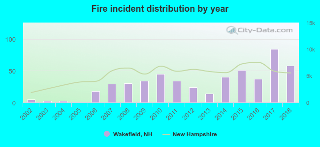 Based on the data from the years 2002 - 2018 the average number of fire incidents per year is 30. The highest number of fires - 84 took place in 2017, and the least - 0 in 2005. The data has a rising trend.
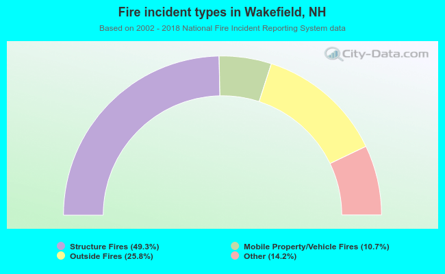 When looking into fire subcategories, the most incidents belonged to: Structure Fires (49.3%), and Outside Fires (25.8%).
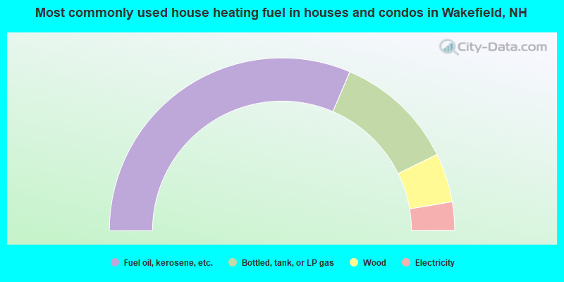
- 62.9%Fuel oil, kerosene, etc.
- 22.6%Bottled, tank, or LP gas
- 9.2%Wood
- 5.3%Electricity
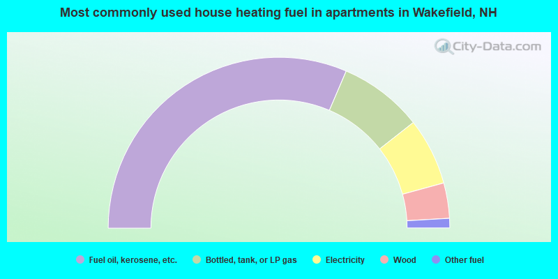
- 62.9%Fuel oil, kerosene, etc.
- 15.9%Bottled, tank, or LP gas
- 12.7%Electricity
- 6.7%Wood
- 1.8%Other fuel
Wakefield compared to New Hampshire state average:
- Unemployed percentage below state average.
- Black race population percentage significantly below state average.
- Hispanic race population percentage significantly below state average.
- Foreign-born population percentage significantly below state average.
- Renting percentage below state average.
- Length of stay since moving in significantly above state average.
- Number of rooms per house significantly below state average.
- House age significantly below state average.
- Percentage of population with a bachelor's degree or higher below state average.
Wakefield on our top lists:
- #3 on the list of "Top 101 cities with largest percentage of females in industries: building material and garden equipment and supplies dealers (population 5,000+)"
- #7 on the list of "Top 101 cities with largest percentage of males in industries: petroleum and petroleum products merchant wholesalers (population 5,000+)"
- #12 on the list of "Top 101 cities with largest percentage of females in occupations: financial managers (population 5,000+)"
- #13 on the list of "Top 101 cities with largest percentage of males in industries: leather and allied products (population 5,000+)"
- #19 on the list of "Top 101 cities with largest percentage of females in occupations: other management occupations except farmers and farm managers (population 5,000+)"
- #21 on the list of "Top 101 cities with largest percentage of males in industries: furniture and home furnishings, and household appliance stores (population 5,000+)"
- #25 on the list of "Top 101 cities with largest percentage of females in industries: paper and paper products merchant wholesalers (population 5,000+)"
- #26 on the list of "Top 101 cities with largest percentage of females in industries: sporting goods, camera, and hobby and toy stores (population 5,000+)"
- #27 on the list of "Top 101 cities with largest percentage of females in industries: food and beverage stores (population 5,000+)"
- #31 on the list of "Top 101 cities with largest percentage of females in occupations: fishing and hunting, and forest and logging workers (population 5,000+)"
- #32 on the list of "Top 101 cities with largest percentage of males in occupations: supervisors of transportation and material moving workers (population 5,000+)"
- #33 on the list of "Top 101 cities with largest percentage of females in industries: computer and electronic products (population 5,000+)"
- #44 on the list of "Top 101 cities with largest percentage of females in occupations: communications equipment operators (population 5,000+)"
- #60 on the list of "Top 101 cities with largest percentage of males in occupations: electrical equipment mechanics and other installation, maintenance, and repair occupations including supervisors (population 5,000+)"
- #63 on the list of "Top 101 cities with largest percentage of males in industries: metals and minerals, except petroleum, merchant wholesalers (population 5,000+)"
- #67 on the list of "Top 101 cities with largest percentage of females in industries: electronic shopping and mail-order houses (population 5,000+)"
- #68 on the list of "Top 101 cities with largest percentage of females in industries: motor vehicles, parts and supplies merchant wholesalers (population 5,000+)"
- #74 on the list of "Top 101 cities with largest percentage of males in industries: hardware, plumbing and heating equipment, and supplies merchant wholesalers (population 5,000+)"
- #75 on the list of "Top 101 cities with largest percentage of females in industries: leather and allied products (population 5,000+)"
- #76 on the list of "Top 101 cities with largest percentage of males in industries: electrical equipment, appliances, and components (population 5,000+)"

|
Total of 4 patent applications in 2008-2024.