Walnut Ridge, Arkansas
Submit your own pictures of this city and show them to the world
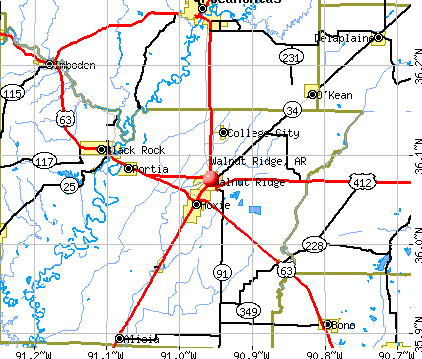
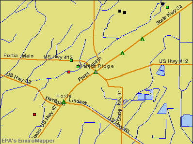
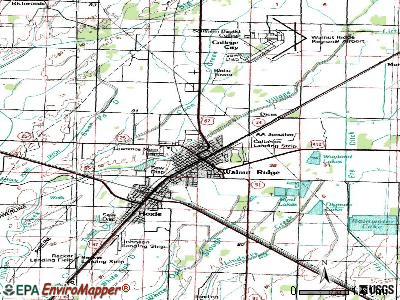
- OSM Map
- General Map
- Google Map
- MSN Map
Population change since 2000: +11.5%
 |
| Males: 2,778 | |
| Females: 2,714 |
| Median resident age: | 39.4 years |
| Arkansas median age: | 38.9 years |
Zip codes: 72476.
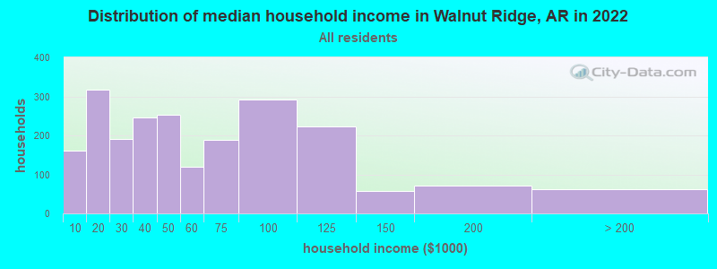
| Walnut Ridge: | $45,213 |
| AR: | $55,432 |
Estimated per capita income in 2022: $25,014 (it was $14,974 in 2000)
Walnut Ridge city income, earnings, and wages data
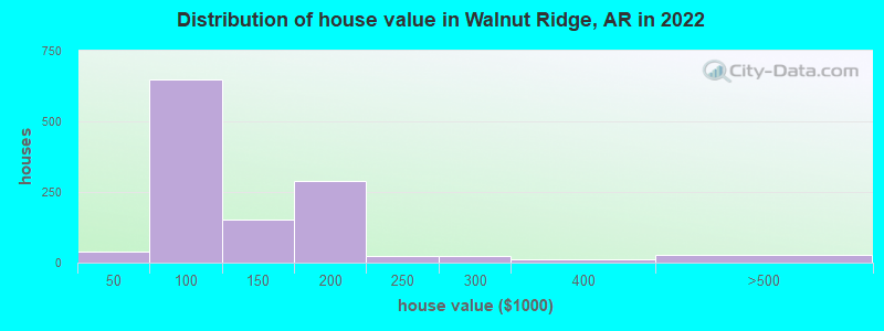
Estimated median house or condo value in 2022: $96,654 (it was $51,400 in 2000)
| Walnut Ridge: | $96,654 |
| AR: | $179,800 |
Mean prices in 2022: all housing units: $143,298; detached houses: $144,961; mobile homes: $56,135
Median gross rent in 2022: $686.
(21.5% for White Non-Hispanic residents, 21.4% for Hispanic or Latino residents, 66.7% for two or more races residents)
Detailed information about poverty and poor residents in Walnut Ridge, AR
Compare current foreclosures near Walnut Ridge, AR:
| Photo | Address | Area | Beds / Baths | Price | Details |
|---|---|---|---|---|---|

|
#1
NW 2nd St
Walnut Ridge, AR 72476
|
1,862 sq. feet
|
2 baths 3 beds |
show details | |

|
#2
NW 3rd St
Walnut Ridge, AR 72476
|
1,813 sq. feet
|
2 baths - beds |
show details | |

|
#3
W Walnut St
Walnut Ridge, AR 72476
|
1,144 sq. feet
|
1 baths - beds |
show details | |

|
#4
Jay St
Walnut Ridge, AR 72476
|
1,577 sq. feet
|
1 baths - beds |
show details | |

|
#5
W Poplar St
Walnut Ridge, AR 72476
|
1,843 sq. feet
|
2 baths - beds |
show details | |

|
#6
E Walnut St
Walnut Ridge, AR 72476
|
2,211 sq. feet
|
1 baths - beds |
show details | |

|
#7
Lawrence Road 431
Walnut Ridge, AR 72476
|
- sq. feet
|
- baths - beds |
show details | |

|
#8
NW 6th St
Walnut Ridge, AR 72476
|
- sq. feet
|
- baths - beds |
show details | |

|
#9
Pyramid Rd
Walnut Ridge, AR 72476
|
- sq. feet
|
- baths - beds |
show details | |

|
#10
Highway 412 W
Walnut Ridge, AR 72476
|
1,280 sq. feet
|
- baths - beds |
show details |
| Photo | Address | Area | Beds / Baths | Price | Details |
|---|---|---|---|---|---|

|
#11
NE 2nd St
Walnut Ridge, AR 72476
|
- sq. feet
|
- baths - beds |
show details | |

|
#12
Lawrence 403
Walnut Ridge, AR 72476
|
- sq. feet
|
- baths - beds |
show details | |

|
#13
Highway 63
Black Rock, AR 72415
|
992 sq. feet
|
1 baths 3 beds |
$99,900
|
show details |

|
#14
Larkspur St
Walnut Ridge, AR 72476
|
- sq. feet
|
- baths - beds |
show details | |

|
#15
N Pratt St
Pocahontas, AR 72455
|
2,460 sq. feet
|
1 baths - beds |
$24,900
|
show details |

|
#16
N Deborah St
Bono, AR 72416
|
1,325 sq. feet
|
1 baths 3 beds |
show details | |

|
#17
Greene Road 229
Delaplaine, AR 72425
|
1,765 sq. feet
|
2 baths 3 beds |
show details | |

|
#18
Oak St
Pocahontas, AR 72455
|
1,149 sq. feet
|
1 baths 3 beds |
show details | |

|
#19
W Pine St
Pocahontas, AR 72455
|
1,324 sq. feet
|
2 baths 3 beds |
show details | |

|
#20
Highway 228
Bono, AR 72416
|
1,668 sq. feet
|
1 baths 4 beds |
show details |
| Photo | Address | Area | Beds / Baths | Price | Details |
|---|---|---|---|---|---|

|
#21
SW Broad St
Hoxie, AR 72433
|
1,341 sq. feet
|
2 baths 3 beds |
show details | |

|
#22
W Black St
Pocahontas, AR 72455
|
1,403 sq. feet
|
1 baths - beds |
show details | |

|
#23
Paula St
Pocahontas, AR 72455
|
1,694 sq. feet
|
2 baths - beds |
show details | |

|
#24
Harmony Rd
Pocahontas, AR 72455
|
1,792 sq. feet
|
2 baths - beds |
show details | |

|
#25
Oak Ct
Pocahontas, AR 72455
|
2,347 sq. feet
|
2 baths - beds |
show details | |

|
#26
County Road 384
Bono, AR 72416
|
1,325 sq. feet
|
1 baths - beds |
show details | |

|
#27
Alta St
Bono, AR 72416
|
1,072 sq. feet
|
1 baths - beds |
show details | |

|
#28
Lakeshore Rd
Pocahontas, AR 72455
|
2,386 sq. feet
|
2 baths - beds |
show details | |

|
#29
Michael St
Bono, AR 72416
|
1,404 sq. feet
|
1 baths - beds |
show details | |

|
#30
Britt Trl
Pocahontas, AR 72455
|
1,500 sq. feet
|
1 baths - beds |
show details |
| Photo | Address | Area | Beds / Baths | Price | Details |
|---|---|---|---|---|---|

|
#31
Britt Trl
Pocahontas, AR 72455
|
1,040 sq. feet
|
1 baths - beds |
show details | |

|
#32
County Road 323
Bono, AR 72416
|
1,048 sq. feet
|
1 baths - beds |
show details | |

|
#33
County Road 318
Bono, AR 72416
|
2,882 sq. feet
|
2 baths - beds |
show details | |

|
#34
County Road 300
Jonesboro, AR 72401
|
740 sq. feet
|
1 baths - beds |
show details | |

|
#35
Engelberg Rd
Pocahontas, AR 72455
|
1,740 sq. feet
|
3 baths - beds |
show details | |

|
#36
N Pratt St
Pocahontas, AR 72455
|
748 sq. feet
|
1 baths - beds |
show details | |

|
#37
Payne St
Pocahontas, AR 72455
|
1,008 sq. feet
|
1 baths - beds |
show details | |

|
#38
SW Broad St
Hoxie, AR 72433
|
1,320 sq. feet
|
1 baths - beds |
show details | |

|
#39
County Road 360
Jonesboro, AR 72401
|
2,135 sq. feet
|
2 baths - beds |
show details | |

|
#40
Gardner St
Pocahontas, AR 72455
|
1,696 sq. feet
|
1 baths - beds |
show details |
| Photo | Address | Area | Beds / Baths | Price | Details |
|---|---|---|---|---|---|

|
#41
Pyburn Ext
Pocahontas, AR 72455
|
1,050 sq. feet
|
1 baths - beds |
show details | |

|
#42
Highway 62 W
Pocahontas, AR 72455
|
2,610 sq. feet
|
2 baths - beds |
show details | |

|
#43
N Bryant St
Pocahontas, AR 72455
|
1,344 sq. feet
|
1 baths - beds |
show details | |

|
#44
Newberry Rd
Pocahontas, AR 72455
|
1,092 sq. feet
|
1 baths - beds |
show details | |

|
#45
Greene Road 652
Beech Grove, AR 72412
|
1,624 sq. feet
|
1 baths - beds |
show details | |

|
#46
Lawrence Road 730
Alicia, AR 72410
|
1,320 sq. feet
|
1 baths - beds |
show details | |

|
#47
Michael St
Bono, AR 72416
|
1,126 sq. feet
|
2 baths - beds |
show details | |

|
#48
County Road 3335
Jonesboro, AR 72401
|
- sq. feet
|
- baths - beds |
show details | |

|
#49
County Road 323
Bono, AR 72416
|
- sq. feet
|
- baths - beds |
show details | |

|
Check over 1 million property listings on Foreclosure.com!
|
browse all offers | |||


- 4,94090.5%White alone
- 1362.5%Hispanic
- 1242.3%Black alone
- 1172.1%Two or more races
- 110.2%American Indian alone
- 50.09%Asian alone

According to our research of Arkansas and other state lists, there were 16 registered sex offenders living in Walnut Ridge, Arkansas as of April 19, 2024.
The ratio of all residents to sex offenders in Walnut Ridge is 297 to 1.
Type |
2009 |
2010 |
2011 |
2012 |
2013 |
2014 |
2015 |
2016 |
2017 |
2018 |
2019 |
2020 |
2021 |
2022 |
|---|---|---|---|---|---|---|---|---|---|---|---|---|---|---|
| Murders (per 100,000) | 0 (0.0) | 0 (0.0) | 0 (0.0) | 0 (0.0) | 0 (0.0) | 0 (0.0) | 0 (0.0) | 0 (0.0) | 0 (0.0) | 0 (0.0) | 0 (0.0) | 0 (0.0) | 0 (0.0) | 0 (0.0) |
| Rapes (per 100,000) | 2 (43.1) | 0 (0.0) | 0 (0.0) | 2 (41.3) | 0 (0.0) | 6 (126.7) | 4 (85.2) | 6 (129.6) | 3 (64.7) | 5 (99.7) | 2 (39.8) | 4 (79.6) | 2 (38.9) | 2 (36.4) |
| Robberies (per 100,000) | 0 (0.0) | 0 (0.0) | 0 (0.0) | 1 (20.7) | 0 (0.0) | 0 (0.0) | 0 (0.0) | 0 (0.0) | 0 (0.0) | 0 (0.0) | 0 (0.0) | 0 (0.0) | 1 (19.5) | 0 (0.0) |
| Assaults (per 100,000) | 9 (194.1) | 3 (61.3) | 5 (101.5) | 8 (165.2) | 6 (127.3) | 10 (211.2) | 8 (170.4) | 16 (345.6) | 13 (280.3) | 10 (199.5) | 9 (179.3) | 19 (378.3) | 23 (447.7) | 16 (291.2) |
| Burglaries (per 100,000) | 32 (690.3) | 23 (470.3) | 30 (608.9) | 19 (392.4) | 27 (572.8) | 15 (316.8) | 23 (489.9) | 21 (453.6) | 20 (431.2) | 19 (379.0) | 22 (438.3) | 19 (378.3) | 15 (292.0) | 20 (364.0) |
| Thefts (per 100,000) | 45 (970.7) | 24 (490.8) | 34 (690.1) | 55 (1,136) | 54 (1,146) | 74 (1,563) | 51 (1,086) | 73 (1,577) | 59 (1,272) | 53 (1,057) | 42 (836.8) | 35 (696.8) | 51 (992.8) | 23 (418.6) |
| Auto thefts (per 100,000) | 2 (43.1) | 3 (61.3) | 1 (20.3) | 1 (20.7) | 1 (21.2) | 4 (84.5) | 3 (63.9) | 4 (86.4) | 2 (43.1) | 3 (59.8) | 8 (159.4) | 6 (119.5) | 5 (97.3) | 9 (163.8) |
| Arson (per 100,000) | 2 (43.1) | 0 (0.0) | 0 (0.0) | 0 (0.0) | 0 (0.0) | 1 (21.1) | 1 (21.3) | 1 (21.6) | 2 (43.1) | 3 (59.8) | 0 (0.0) | 1 (19.9) | 0 (0.0) | 1 (18.2) |
| City-Data.com crime index | 163.9 | 69.7 | 92.1 | 146.8 | 113.1 | 235.1 | 185.1 | 274.5 | 192.3 | 193.3 | 144.7 | 203.3 | 194.5 | 142.7 |
The City-Data.com crime index weighs serious crimes and violent crimes more heavily. Higher means more crime, U.S. average is 246.1. It adjusts for the number of visitors and daily workers commuting into cities.

Crime rate in Walnut Ridge detailed stats: murders, rapes, robberies, assaults, burglaries, thefts, arson
Full-time law enforcement employees in 2021, including police officers: 9 (9 officers - 8 male; 1 female).
| Officers per 1,000 residents here: | 1.75 |
| Arkansas average: | 2.25 |
 Recent articles from our blog. Our writers, many of them Ph.D. graduates or candidates, create easy-to-read articles on a wide variety of topics.


 | Walnut Ridge area pros and cons please (3 replies) |
| NWA's Hwy. 412 to be designated as future interstate (18 replies) |
| Hopefully moving to Arkansas for retirement (86 replies) |
| Planning Move to North Central Arkansas (50 replies) |
| Which is better: Pocahontas or Paragould? (23 replies) |
| walnut Ridge dogcatcher (8 replies) |
Latest news from Walnut Ridge, AR collected exclusively by city-data.com from local newspapers, TV, and radio stations
Ancestries: American (29.9%), English (14.0%), German (13.8%), Irish (11.4%), Italian (1.8%), Swedish (1.7%).
Current Local Time: CST time zone
Incorporated on 10/29/1880
Elevation: 270 feet
Land area: 11.6 square miles.
Population density: 475 people per square mile (low).

108 residents are foreign born
| This city: | 2.0% |
| Arkansas: | 5.0% |
Median real estate property taxes paid for housing units with mortgages in 2022: $501 (0.5%)
Median real estate property taxes paid for housing units with no mortgage in 2022: $435 (0.5%)
Nearest city with pop. 50,000+: Jonesboro, AR  (22.4 miles , pop. 55,515).
Nearest city with pop. 200,000+: Memphis, TN (86.2 miles , pop. 650,100).
Nearest city with pop. 1,000,000+: Dallas, TX (402.2 miles , pop. 1,188,580).
Nearest cities:
), ), )Latitude: 36.07 N, Longitude: 90.96 W
Daytime population change due to commuting: +858 (+15.7%)
Workers who live and work in this city: 1,157 (49.8%)
Area code: 870
Walnut Ridge, Arkansas accommodation & food services, waste management - Economy and Business Data
Single-family new house construction building permits:
- 2022: 3 buildings, average cost: $162,300
- 2021: 12 buildings, average cost: $154,500
- 2020: 7 buildings, average cost: $177,900
- 2019: 11 buildings, average cost: $140,000
- 2018: 11 buildings, average cost: $78,900
- 2017: 10 buildings, average cost: $147,100
- 2016: 12 buildings, average cost: $116,800
- 2015: 8 buildings, average cost: $219,600
- 2010: 2 buildings, average cost: $175,600
- 2009: 6 buildings, average cost: $62,500
- 2008: 8 buildings, average cost: $62,500
- 2007: 5 buildings, average cost: $170,500
- 2006: 7 buildings, average cost: $87,500
- 2005: 7 buildings, average cost: $87,500
- 2004: 6 buildings, average cost: $87,500
- 2003: 1 building, cost: $175,000
- 2001: 6 buildings, average cost: $87,800
- 2000: 5 buildings, average cost: $148,800
- 1999: 7 buildings, average cost: $126,300
- 1998: 6 buildings, average cost: $87,000
- 1997: 9 buildings, average cost: $86,100


| Here: | 3.6% |
| Arkansas: | 3.4% |


Population change in the 1990s: +463 (+10.4%).

- Health care (10.1%)
- Educational services (9.3%)
- Machinery (6.7%)
- Construction (5.6%)
- Accommodation & food services (5.4%)
- Food & beverage stores (4.3%)
- Professional, scientific, technical services (4.1%)

- Construction (9.1%)
- Educational services (8.2%)
- Agriculture, forestry, fishing & hunting (7.1%)
- Machinery (6.1%)
- Truck transportation (5.5%)
- Motor vehicle & parts dealers (4.2%)
- Metal & metal products (4.2%)

- Health care (18.6%)
- Educational services (10.7%)
- Machinery (7.4%)
- Accommodation & food services (7.2%)
- Department & other general merchandise stores (5.2%)
- Food & beverage stores (5.0%)
- Public administration (4.9%)

- Metal workers and plastic workers (5.4%)
- Secretaries and administrative assistants (4.9%)
- Other production occupations, including supervisors (4.9%)
- Driver/sales workers and truck drivers (4.6%)
- Other office and administrative support workers, including supervisors (4.5%)
- Building and grounds cleaning and maintenance occupations (4.5%)
- Cashiers (3.8%)

- Driver/sales workers and truck drivers (8.6%)
- Metal workers and plastic workers (7.8%)
- Other production occupations, including supervisors (5.6%)
- Electrical equipment mechanics and other installation, maintenance, and repair workers, including supervisors (5.3%)
- Other management occupations, except farmers and farm managers (4.9%)
- Retail sales workers, except cashiers (4.5%)
- Carpenters (3.8%)

- Secretaries and administrative assistants (10.7%)
- Other office and administrative support workers, including supervisors (9.0%)
- Cashiers (8.3%)
- Building and grounds cleaning and maintenance occupations (6.1%)
- Assemblers and fabricators (5.9%)
- Health technologists and technicians (5.3%)
- Other production occupations, including supervisors (4.0%)
Average climate in Walnut Ridge, Arkansas
Based on data reported by over 4,000 weather stations


|
|

Tornado activity:
Walnut Ridge-area historical tornado activity is near Arkansas state average. It is 112% greater than the overall U.S. average.
On 5/26/1973, a category F4 (max. wind speeds 207-260 mph) tornado 22.8 miles away from the Walnut Ridge city center killed 3 people and injured 289 people and caused between $5000 and $50,000 in damages.
On 5/15/1968, a category F4 tornado 26.8 miles away from the city center killed 35 people and injured 364 people and caused between $5000 and $50,000 in damages.
Earthquake activity:
Walnut Ridge-area historical earthquake activity is significantly above Arkansas state average. It is 460% greater than the overall U.S. average.On 3/25/1976 at 00:41:20, a magnitude 5.0 (4.9 MB, 5.0 LG, Class: Moderate, Intensity: VI - VII) earthquake occurred 46.4 miles away from the city center
On 5/4/1991 at 01:18:54, a magnitude 5.0 (4.4 MB, 4.6 LG, 5.0 LG, Depth: 3.1 mi) earthquake occurred 71.8 miles away from Walnut Ridge center
On 9/26/1990 at 13:18:51, a magnitude 5.0 (4.7 MB, 4.8 LG, 5.0 LG, Depth: 7.7 mi) earthquake occurred 109.4 miles away from the city center
On 4/27/1989 at 16:47:49, a magnitude 4.7 (4.6 MB, 4.7 LG, 4.3 LG, Class: Light, Intensity: IV - V) earthquake occurred 66.7 miles away from the city center
On 3/25/1976 at 01:00:11, a magnitude 4.5 (4.1 MB, 4.5 LG) earthquake occurred 41.7 miles away from the city center
On 5/4/2001 at 06:42:12, a magnitude 4.7 (4.2 MB, 4.7 LG, 4.5 LG) earthquake occurred 91.9 miles away from Walnut Ridge center
Magnitude types: regional Lg-wave magnitude (LG), body-wave magnitude (MB)
Natural disasters:
The number of natural disasters in Lawrence County (17) is near the US average (15).Major Disasters (Presidential) Declared: 13
Emergencies Declared: 2
Causes of natural disasters: Storms: 11, Floods: 9, Tornadoes: 9, Winds: 2, Winter Storms: 2, Hurricane: 1, Ice Storm: 1, Tropical Storm: 1, Other: 1 (Note: some incidents may be assigned to more than one category).
Hospitals and medical centers in Walnut Ridge:
- LAWRENCE MEMORIAL HOSPITAL (Government - Local, provides emergency services, 1309 WEST MAIN)
- LAWRENCE COUNTY HEALTH UNIT (1050 WEST FREE STREET)
- LAWRENCE HALL EAST (311 NORTHWEST 2ND)
- LAWRENCE HALL NURSING CENTER (1051 WEST FREE STREET)
- WALNUT RIDGE CONVALESCENT CENTER (1500 W MAIN)
- WALNUT RIDGE NURSING AND REHABILITATION CENTER (1500 WEST MAIN)
Airports and heliports located in Walnut Ridge:
- Walnut Ridge Regional Airport (ARG) (Runways: 3, Air Taxi Ops: 300, Itinerant Ops: 5,000, Local Ops: 54,000, Military Ops: 2,000)
- Lawrence Memorial Heliport (AR20)
College/University in Walnut Ridge:
Colleges/universities with over 2000 students nearest to Walnut Ridge:
- Arkansas State University-Main Campus (about 23 miles; Jonesboro, AR; Full-time enrollment: 12,323)
- Three Rivers Community College (about 57 miles; Poplar Bluff, MO; FT enrollment: 3,360)
- Harding University (about 72 miles; Searcy, AR; FT enrollment: 5,360)
- Southwest Tennessee Community College (about 83 miles; Memphis, TN; FT enrollment: 8,043)
- Rhodes College (about 84 miles; Memphis, TN; FT enrollment: 2,052)
- University of Memphis (about 86 miles; Memphis, TN; FT enrollment: 17,427)
- Arkansas State University-Beebe (about 87 miles; Beebe, AR; FT enrollment: 3,387)
Public high school in Walnut Ridge:
- WALNUT RIDGE HIGH SCHOOL (Location: 508 E FREE ST, Grades: 7-12)
Public elementary/middle school in Walnut Ridge:
- WALNUT RIDGE ELEMENTARY SCHOOL (Location: 508 E FREE ST, Grades: PK-6)
Points of interest:
Notable locations in Walnut Ridge: Walnut Ridge City Hall (A), Lawrence County Courthouse (B), Sheltering Arms Nursing Home (C), Lawrence County Library (D), Walnut Ridge Fire Department Station 1 (E), Lawrence County Sheriff's Office (F), Walnut Ridge Police Department (G), Arkansas Excellent Transport (H). Display/hide their locations on the map
Shopping Center: Clark Shopping Center (1). Display/hide its location on the map
Churches in Walnut Ridge include: White Oak Church (A), Main Street Church of Christ (B). Display/hide their locations on the map
Cemetery: Lawrence Memorial Park (1). Display/hide its location on the map
Park in Walnut Ridge: Stewart Park (1). Display/hide its location on the map
Hotel: Phillips Motel (501 Highway 67 North).
Court: Lawrence-County - Municipal Court Clerk (201 Southwest 2nd Street).
Birthplace of: Ehron VonAllen - Musician, James T. Conway - 34th Commandant of the Marine Corps.
| This city: | 2.3 people |
| Arkansas: | 2.5 people |
| This city: | 62.7% |
| Whole state: | 67.6% |
| This city: | 5.3% |
| Whole state: | 5.7% |
Likely homosexual households (counted as self-reported same-sex unmarried-partner households)
- Lesbian couples: 0.4% of all households
- Gay men: 0.2% of all households
People in group quarters in Walnut Ridge in 2010:
- 258 people in nursing facilities/skilled-nursing facilities
- 32 people in local jails and other municipal confinement facilities
- 12 people in emergency and transitional shelters (with sleeping facilities) for people experiencing homelessness
People in group quarters in Walnut Ridge in 2000:
- 253 people in nursing homes
- 30 people in local jails and other confinement facilities (including police lockups)
- 17 people in other nonhousehold living situations
- 7 people in orthopedic wards and institutions for the physically handicapped
Banks with branches in Walnut Ridge (2011 data):
- The First National Bank of Lawrence County at Walnut Ridge: North Branch at 900 Highway 67 North, branch established on 1974/06/14; The First National Bank Of Lawrence at 202 West Main Street, branch established on 1919/03/27. Info updated 2006/11/03: Bank assets: $186.9 mil, Deposits: $166.4 mil, local headquarters, positive income, Agricultural Specialization, 5 total offices, Holding Company: First National Capital Corporation
- Iberiabank: 123 Sw Third St Branch at 123 Southwest Third Street, branch established on 1935/04/01. Info updated 2011/06/08: Bank assets: $11,676.7 mil, Deposits: $9,387.9 mil, headquarters in Lafayette, LA, positive income, Commercial Lending Specialization, 187 total offices, Holding Company: Iberiabank Corporation
- Regions Bank: Walnut Ridge Branch at 212 West Walnut Street, branch established on 1901/03/23. Info updated 2011/02/24: Bank assets: $123,368.2 mil, Deposits: $98,301.3 mil, headquarters in Birmingham, AL, positive income, Commercial Lending Specialization, 1778 total offices, Holding Company: Regions Financial Corporation
For population 15 years and over in Walnut Ridge:

- Never married: 30.4%
- Now married: 44.5%
- Separated: 2.0%
- Widowed: 7.4%
- Divorced: 15.8%
For population 25 years and over in Walnut Ridge:
- High school or higher: 82.5%
- Bachelor's degree or higher: 20.7%
- Graduate or professional degree: 8.8%
- Unemployed: 3.3%
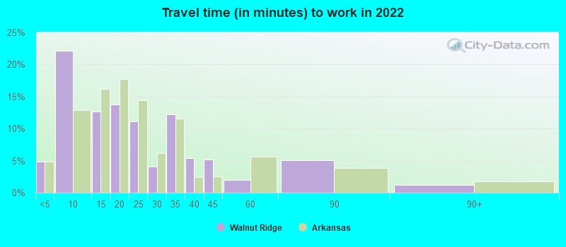
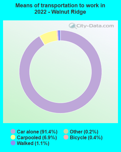
- Mean travel time to work (commute): 16.0 minutes


| Here: | 11.2 |
| Arkansas average: | 11.4 |


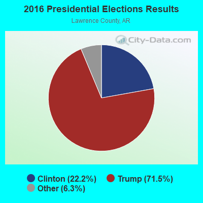
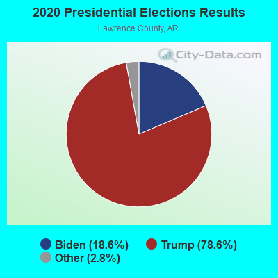
Graphs represent county-level data. Detailed 2008 Election Results
Religion statistics for Walnut Ridge, AR (based on Lawrence County data)
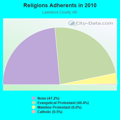
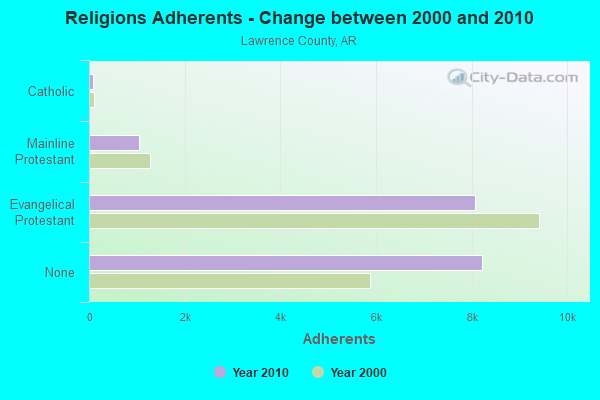
| Religion | Adherents | Congregations |
|---|---|---|
| Evangelical Protestant | 8,078 | 58 |
| Mainline Protestant | 1,038 | 12 |
| Catholic | 85 | 1 |
| Other | 1 | 1 |
| None | 8,213 | - |
Food Environment Statistics:
| This county: | 4.75 / 10,000 pop. |
| Arkansas: | 2.02 / 10,000 pop. |
| Lawrence County: | 1.19 / 10,000 pop. |
| Arkansas: | 0.59 / 10,000 pop. |
| Lawrence County: | 5.35 / 10,000 pop. |
| Arkansas: | 4.94 / 10,000 pop. |
| Lawrence County: | 4.16 / 10,000 pop. |
| Arkansas: | 6.66 / 10,000 pop. |
| Here: | 10.5% |
| State: | 9.8% |
| This county: | 29.6% |
| Arkansas: | 29.1% |
| Lawrence County: | 14.7% |
| Arkansas: | 13.6% |
Health and Nutrition:
| Walnut Ridge: | 48.2% |
| Arkansas: | 48.2% |
| Here: | 42.0% |
| State: | 44.2% |
| Walnut Ridge: | 29.0 |
| Arkansas: | 28.9 |
| Walnut Ridge: | 20.2% |
| Arkansas: | 21.6% |
| This city: | 15.1% |
| Arkansas: | 11.3% |
| This city: | 6.8 |
| State: | 6.8 |
| This city: | 35.6% |
| Arkansas: | 34.0% |
| This city: | 52.3% |
| State: | 54.4% |
| Walnut Ridge: | 74.3% |
| State: | 78.0% |
More about Health and Nutrition of Walnut Ridge, AR Residents
| Local government employment and payroll (March 2022) | |||||
| Function | Full-time employees | Monthly full-time payroll | Average yearly full-time wage | Part-time employees | Monthly part-time payroll |
|---|---|---|---|---|---|
| Firefighters | 11 | $35,404 | $38,623 | 0 | $0 |
| Police Protection - Officers | 9 | $23,445 | $31,260 | 1 | $456 |
| Streets and Highways | 5 | $11,578 | $27,787 | 0 | $0 |
| Solid Waste Management | 2 | $5,654 | $33,924 | 0 | $0 |
| Financial Administration | 1 | $2,790 | $33,480 | 0 | $0 |
| Other Government Administration | 0 | $0 | 2 | $646 | |
| Totals for Government | 28 | $78,872 | $33,802 | 3 | $1,102 |
Walnut Ridge government finances - Expenditure in 2021 (per resident):
- Current Operations - Regular Highways: $322,000 ($58.63)
Local Fire Protection: $318,000 ($57.90)
Police Protection: $255,000 ($46.43)
Solid Waste Management: $159,000 ($28.95)
Central Staff Services: $119,000 ($21.67)
- Total Salaries and Wages: $746,000 ($135.83)
Walnut Ridge government finances - Revenue in 2021 (per resident):
- Charges - Solid Waste Management: $282,000 ($51.35)
- Local Intergovernmental - Highways: $53,000 ($9.65)
- Miscellaneous - Fines and Forfeits: $44,000 ($8.01)
- Tax - General Sales and Gross Receipts: $973,000 ($177.17)
Other License: $39,000 ($7.10)
Occupation and Business License - Other: $24,000 ($4.37)
Walnut Ridge government finances - Cash and Securities in 2021 (per resident):
- Other Funds - Cash and Securities: $1,948,000 ($354.70)
| Businesses in Walnut Ridge, AR | ||||
| Name | Count | Name | Count | |
|---|---|---|---|---|
| AT&T | 1 | SONIC Drive-In | 1 | |
| Chevrolet | 1 | Subway | 1 | |
| FedEx | 2 | True Value | 1 | |
| H&R Block | 1 | U-Haul | 1 | |
| KFC | 1 | UPS | 2 | |
| McDonald's | 1 | Walmart | 1 | |
| Pizza Hut | 1 | |||
Strongest AM radio stations in Walnut Ridge:
- KRLW (1320 AM; 1 kW; WALNUT RIDGE, AR; Owner: COMBINED MEDIA GROUP, INC.)
- WCRV (640 AM; 50 kW; COLLIERVILLE, TN; Owner: BOTT BROADCASTING COMPANY/TENNESSEE)
- WDIA (1070 AM; 50 kW; MEMPHIS, TN; Owner: CLEAR CHANNEL BROADCASTING LICENSES, INC.)
- WGSF (1030 AM; 50 kW; MEMPHIS, TN; Owner: FLINN BROADCASTING CORPORATION)
- KOTC (830 AM; daytime; 10 kW; KENNETT, MO; Owner: EAGLE BLUFF ENTERPRISES)
- WMQM (1600 AM; 50 kW; LAKELAND, TN; Owner: WMQM, INC.)
- KGHT (880 AM; 50 kW; SHERIDAN, AR; Owner: METROPOLITAN RADIO GROUP, INC.)
- KPOC (1420 AM; 1 kW; POCAHONTAS, AR; Owner: COMBINED MEDIA GROUP, INC.)
- KAAY (1090 AM; 50 kW; LITTLE ROCK, AR; Owner: CITADEL BROADCASTING COMPANY)
- KNEA (970 AM; 1 kW; JONESBORO, AR; Owner: CLEAR CHANNEL BROADCASTING LICENSES, INC.)
- WJCE (680 AM; 10 kW; MEMPHIS, TN; Owner: ENTERCOM MEMPHIS LICENSE, LLC)
- KWOC (930 AM; 5 kW; POPLAR BLUFF, MO; Owner: ZIMMER RADIO OF MID-MISSOURI, INC)
- KBTM (1230 AM; 1 kW; JONESBORO, AR; Owner: CAPSTAR TX LIMITED PARTNERSHIP)
Strongest FM radio stations in Walnut Ridge:
- KRLW-FM (106.3 FM; WALNUT RIDGE, AR; Owner: COMBINED MEDIA GROUP, INC.)
- KJLV (105.3 FM; HOXIE, AR; Owner: EDUCATIONAL MEDIA FOUNDATION)
- KIYS (101.9 FM; JONESBORO, AR; Owner: ,CAPSTAR TX LIMITED PARTNERSHIP)
- KASU (91.9 FM; JONESBORO, AR; Owner: ARKANSAS STATE UNIVERSITY)
- KFIN (107.9 FM; JONESBORO, AR; Owner: CAPSTAR TX LIMITED PARTNERSHIP)
- KDEZ (100.5 FM; JONESBORO, AR; Owner: SAGA COMMUNICATIONS OF ARKANSAS, LLC)
- WJZN (98.9 FM; MUNFORD, TN; Owner: MEMPHIS III LIMITED PARTNERSHIP)
- KBZR (95.9 FM; HARRISBURG, AR; Owner: CLEAR CHANNEL BROADCASTING LICENSES, INC.)
- K211BX (90.1 FM; POCAHONTAS, AR; Owner: AMERICAN FAMILY ASSOCIATION)
- KDRS-FM (107.1 FM; PARAGOULD, AR; Owner: MOR MEDIA, INC.)
- KAOG (90.5 FM; JONESBORO, AR; Owner: AMERICAN FAMILY ASSOCIATION)
- KDXY (104.9 FM; LAKE CITY, AR; Owner: SAGA COMMUNICATIONS OF ARKANSAS, LLC)
- KBKG (93.5 FM; CORNING, AR; Owner: SHIELDS-ADKINS BROADCASTING, INC.)
- KPOC-FM (103.9 FM; POCAHONTAS, AR; Owner: COMBINED MEDIA GROUP, INC.)
TV broadcast stations around Walnut Ridge:
- KAIT (Channel 8; JONESBORO, AR; Owner: LIBCO, INC.)
- KTEJ (Channel 19; JONESBORO, AR; Owner: ARKANSAS EDUCATIONAL TELEVISION COMMISSION)
- K46EM (Channel 46; BATESVILLE, AR; Owner: MS COMMUNICATIONS, LLC)
- K54ER (Channel 54; JONESBORO, AR; Owner: TRINITY BROADCASTING NETWORK)
- KVTJ (Channel 48; JONESBORO, AR; Owner: AGAPE CHURCH, INC.)

- National Bridge Inventory (NBI) Statistics
- 47Number of bridges
- 673ft / 205mTotal length
- $1,772,000Total costs
- 190,583Total average daily traffic
- 12,404Total average daily truck traffic

- New bridges - historical statistics
- 41930-1939
- 11950-1959
- 11960-1969
- 41970-1979
- 61990-1999
- 132000-2009
- 12010-2019
- 22020-2022
FCC Registered Cell Phone Towers:
1 (See the full list of FCC Registered Cell Phone Towers in Walnut Ridge)FCC Registered Antenna Towers:
52 (See the full list of FCC Registered Antenna Towers)FCC Registered Private Land Mobile Towers:
1 (See the full list of FCC Registered Private Land Mobile Towers in Walnut Ridge, AR)FCC Registered Broadcast Land Mobile Towers:
22 (See the full list of FCC Registered Broadcast Land Mobile Towers)FCC Registered Microwave Towers:
2- AR01919A, 315 W. Hickory Street (Lat: 36.064139 Lon: -90.966500), Type: Pole, Structure height: 45.7 m, Overall height: 50.3 m, Call Sign: WREL643,
Assigned Frequencies: 10835.0 MHz, 10915.0 MHz, 10835.0 MHz, 10915.0 MHz, 10835.0 MHz, 10915.0 MHz, 10835.0 MHz, 10915.0 MHz, 10835.0 MHz, 10915.0 MHz... (+32 more), Grant Date: 10/29/2019, Expiration Date: 10/29/2029, Certifier: David Werblow, Registrant: T-Mobile Usa, Inc., 12920 Se 38th Street, Bellevue, WA 98006, Phone: (425) 383-8401, Fax: (425) 383-4040, Email:
- WALNUT RDGE, 200 Pine St (Lat: 36.067278 Lon: -90.960667), Overall height: 43.9 m, Call Sign: WCU296,
Assigned Frequencies: 6152.75 MHz, Grant Date: 02/12/1999, Expiration Date: 08/01/2000, Cancellation Date: 09/18/2000, Registrant: Southwestern Bell Telephone Company, 308 S. Akard Three Bell Plaza Room 810.A1, Dallas, TX 75202-5399, Phone: (214) 858-0824, Fax: (214) 858-0510
FCC Registered Paging Towers:
1- Old Pocahontas Road (Lat: 36.077833 Lon: -90.952889), Call Sign: KOR373, Licensee ID: L00129112,
Assigned Frequencies: 454.150 MHz, Grant Date: 05/24/1999, Expiration Date: 04/01/2009, Cancellation Date: 05/23/2009, Registrant: Radio Communications Center, 3508 E. Highland Drive, Jonesboro, AR 72401, Phone: (870) 972-1000
FCC Registered Maritime Coast & Aviation Ground Towers:
3- Walnut Ridge Regional Airport (Lat: 36.125056 Lon: -90.925111), Type: Tower, Overall height: 0 m, Call Sign: WIW4,
Assigned Frequencies: 122.800 MHz, Grant Date: 05/08/2019, Expiration Date: 05/19/2028, Registrant: 11 Skywatch, Walnut Ridge, AR 72476, Phone: (870) 886-5432
- Walnut Ridge Regional Airport (Lat: 36.205611 Lon: -90.923167), Type: Tower, Call Sign: WRLB2774, Licensee ID: L00013885,
Assigned Frequencies: 0.22751 MHz, Grant Date: 12/06/2001, Expiration Date: 08/17/2006, Cancellation Date: 10/21/2006, Registrant: City Of Walnut Ridge, 11 Sky Watch, Walnut Ridge, AR 72476
- Walnut Ridge Airport (Lat: 36.116167 Lon: -90.923167), Type: Tower, Call Sign: WRLL2130, Licensee ID: L00015112,
Assigned Frequencies: 111.100 MHz, Grant Date: 07/28/2003, Expiration Date: 03/17/2008, Cancellation Date: 05/17/2008, Registrant: Walnut Ridge Airport Commission, 11 Sky Watch, Walnut Ridge, AR 72476
FCC Registered Amateur Radio Licenses:
67 (See the full list of FCC Registered Amateur Radio Licenses in Walnut Ridge)FAA Registered Aircraft Manufacturers and Dealers:
5 (See the full list of FAA Registered Manufacturers and Dealers in Walnut Ridge)FAA Registered Aircraft:
59 (See the full list of FAA Registered Aircraft)2002 - 2018 National Fire Incident Reporting System (NFIRS) incidents
- Fire incident types reported to NFIRS in Walnut Ridge, AR
- 43948.1%Outside Fires
- 31434.4%Structure Fires
- 13514.8%Mobile Property/Vehicle Fires
- 242.6%Other
 Based on the data from the years 2002 - 2018 the average number of fire incidents per year is 54. The highest number of reported fires - 87 took place in 2005, and the least - 5 in 2002. The data has a growing trend.
 When looking into fire subcategories, the most reports belonged to: Outside Fires (48.1%), and Structure Fires (34.4%).
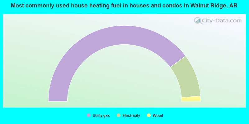
- 79.6%Utility gas
- 18.2%Electricity
- 2.2%Wood
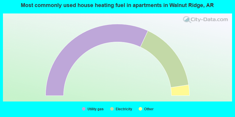
- 64.0%Utility gas
- 31.3%Electricity
- 3.5%Bottled, tank, or LP gas
- 1.2%Other fuel
Walnut Ridge compared to Arkansas state average:
- Median house value below state average.
- Unemployed percentage significantly below state average.
- Black race population percentage significantly below state average.
- Hispanic race population percentage significantly below state average.
- Median age above state average.
- Foreign-born population percentage significantly below state average.
- Length of stay since moving in above state average.
- Institutionalized population percentage above state average.
Walnut Ridge on our top lists:
- #96 on the list of "Top 101 cities with the largest percentage of people in orthopedic wards and institutions for the physically handicapped (population 1,000+)"
- #42 on the list of "Top 101 counties with highest percentage of residents voting for 3rd party candidates in the 2012 Presidential Election"