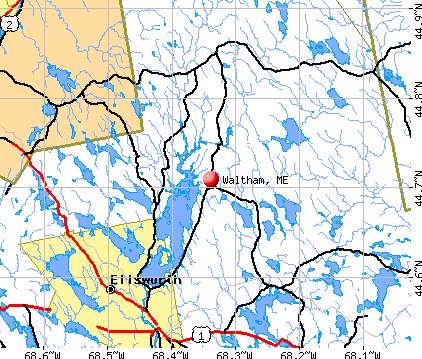
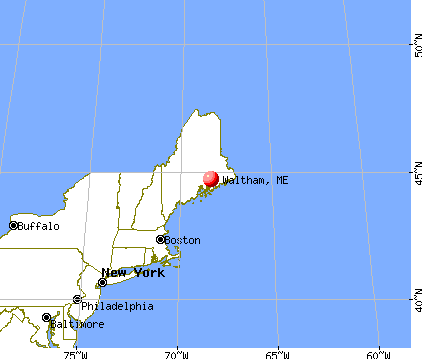
Waltham, Maine
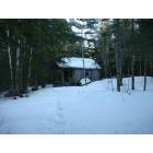
Submit your own pictures of this town and show them to the world
- OSM Map
- General Map
- Google Map
- MSN Map
Population change since 2000: +15.4%
| Males: 177 | |
| Females: 176 |
| Median resident age: | 47.2 years |
| Maine median age: | 43.0 years |
Zip codes: 04605.
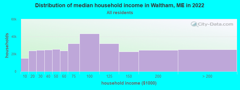
| Waltham: | $71,489 |
| ME: | $69,543 |
Estimated per capita income in 2022: $27,344 (it was $13,467 in 2000)
Waltham town income, earnings, and wages data
Estimated median house or condo value in 2022: $219,944 (it was $76,800 in 2000)
| Waltham: | $219,944 |
| ME: | $290,600 |
Mean prices in 2022: all housing units: $379,336; detached houses: $396,802; townhouses or other attached units: $600,716; in 2-unit structures: $274,479; in 3-to-4-unit structures: $212,346; in 5-or-more-unit structures: $146,369; mobile homes: $158,183; occupied boats, rvs, vans, etc.: $16,454
Detailed information about poverty and poor residents in Waltham, ME


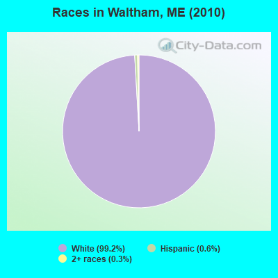
- 35099.2%White alone
- 20.6%Hispanic
- 10.3%Two or more races
Races in Waltham detailed stats: ancestries, foreign born residents, place of birth
 Recent articles from our blog. Our writers, many of them Ph.D. graduates or candidates, create easy-to-read articles on a wide variety of topics.


 | Where in Maine Would You Live if You Could? (98 replies) |
| Reasonably-priced hotels outside of Acadia (10 replies) |
| UPDATE'S, Where are you in life, and your move to Maine (1003 replies) |
| Seed catalogs (67 replies) |
| T3 ND Twp (21 replies) |
| Waltham (5 replies) |
Latest news from Waltham, ME collected exclusively by city-data.com from local newspapers, TV, and radio stations
Ancestries: United States (49.0%), English (23.9%), French (9.5%), Scottish (8.8%), Irish (7.2%), German (3.3%).
Current Local Time: EST time zone
Incorporated on 01/29/1833
Elevation: 342 feet
Land area: 29.7 square miles.
Population density: 12 people per square mile (very low).
| Waltham town: | 1.4% ($1,038) |
| Maine: | 1.5% ($1,417) |
Nearest city with pop. 50,000+: Portland, ME  (119.3 miles , pop. 64,249).
Nearest city with pop. 200,000+: Boston, MA (214.3 miles , pop. 589,141).
Nearest city with pop. 1,000,000+: Bronx, NY (386.8 miles , pop. 1,332,650).
Nearest cities:
), Latitude: 44.69 N, Longitude: 68.33 W
Area code commonly used in this area: 207

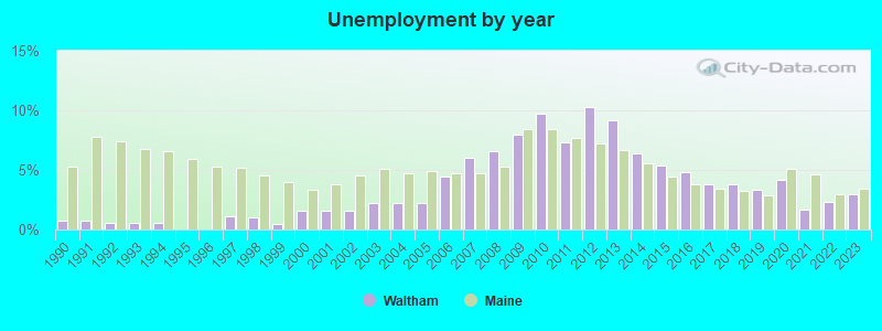
| Here: | 3.0% |
| Maine: | 3.4% |
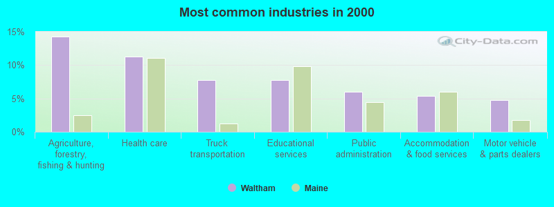
- Agriculture, forestry, fishing & hunting (14.3%)
- Health care (11.3%)
- Truck transportation (7.7%)
- Educational services (7.7%)
- Public administration (6.0%)
- Accommodation & food services (5.4%)
- Motor vehicle & parts dealers (4.8%)
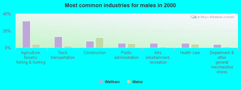
- Agriculture, forestry, fishing & hunting (31.6%)
- Truck transportation (13.2%)
- Construction (7.9%)
- Public administration (5.3%)
- Arts, entertainment, recreation (5.3%)
- Health care (5.3%)
- Department & other general merchandise stores (3.9%)

- Health care (16.3%)
- Educational services (14.1%)
- Accommodation & food services (9.8%)
- Motor vehicle & parts dealers (6.5%)
- Public administration (6.5%)
- Food (5.4%)
- Finance & insurance (5.4%)

- Fishing, hunting, and forestry occupations (8.9%)
- Secretaries and administrative assistants (6.5%)
- Building and grounds cleaning and maintenance occupations (4.8%)
- Textile, apparel, and furnishings workers (4.8%)
- Other office and administrative support workers, including supervisors (4.8%)
- Other sales and related occupations, including supervisors (4.2%)
- Driver/sales workers and truck drivers (4.2%)

- Fishing, hunting, and forestry occupations (19.7%)
- Driver/sales workers and truck drivers (9.2%)
- Construction traders workers except carpenters, electricians, painters, plumbers, and construction laborers (6.6%)
- Other production occupations, including supervisors (6.6%)
- Art and design workers (5.3%)
- Fire fighting and prevention workers, including supervisors (5.3%)
- Counselors, social workers, and other community and social service specialists (5.3%)

- Secretaries and administrative assistants (12.0%)
- Other office and administrative support workers, including supervisors (8.7%)
- Other teachers, instructors, education, training, and library occupations (6.5%)
- Building and grounds cleaning and maintenance occupations (6.5%)
- Preschool, kindergarten, elementary, and middle school teachers (5.4%)
- Nursing, psychiatric, and home health aides (5.4%)
- Registered nurses (5.4%)
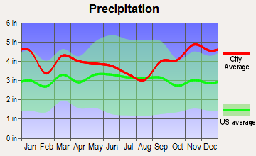
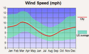
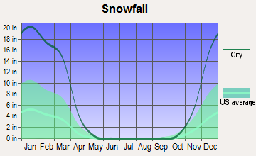
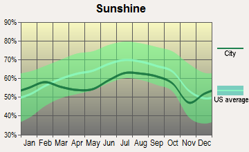
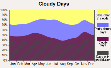
Average climate in Waltham, Maine
Based on data reported by over 4,000 weather stations


(lower is better)
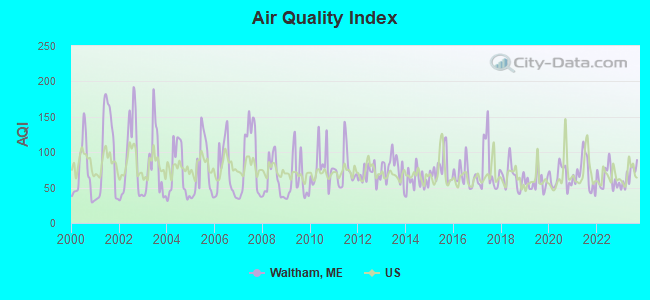
Air Quality Index (AQI) level in 2023 was 66.6. This is about average.
| City: | 66.6 |
| U.S.: | 72.6 |
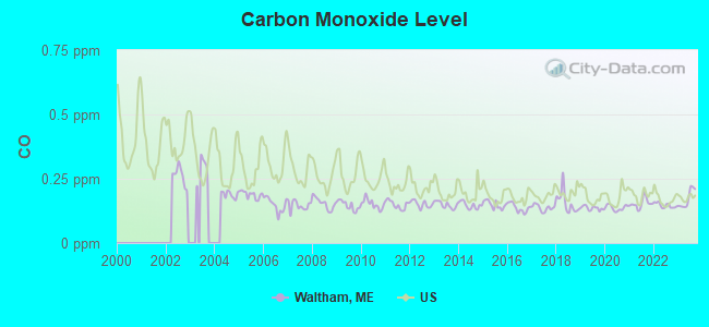
Carbon Monoxide (CO) [ppm] level in 2023 was 0.172. This is significantly better than average. Closest monitor was 14.0 miles away from the city center.
| City: | 0.172 |
| U.S.: | 0.251 |
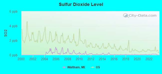
Sulfur Dioxide (SO2) [ppb] level in 2023 was 0.0636. This is significantly better than average. Closest monitor was 14.0 miles away from the city center.
| City: | 0.0636 |
| U.S.: | 1.5147 |
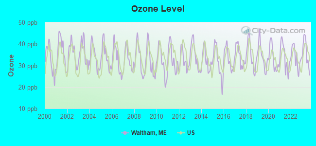
Ozone [ppb] level in 2023 was 35.7. This is about average. Closest monitor was 14.0 miles away from the city center.
| City: | 35.7 |
| U.S.: | 33.3 |
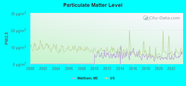
Particulate Matter (PM2.5) [µg/m3] level in 2023 was 5.24. This is significantly better than average. Closest monitor was 22.0 miles away from the city center.
| City: | 5.24 |
| U.S.: | 8.11 |
Earthquake activity:
Waltham-area historical earthquake activity is significantly above Maine state average. It is 81% smaller than the overall U.S. average.On 10/16/2012 at 23:12:25, a magnitude 4.7 (4.7 ML, Depth: 10.0 mi, Class: Light, Intensity: IV - V) earthquake occurred 137.8 miles away from the city center
On 4/20/2002 at 10:50:47, a magnitude 5.3 (5.3 ML, Depth: 3.0 mi, Class: Moderate, Intensity: VI - VII) earthquake occurred 264.3 miles away from the city center
On 4/20/2002 at 10:50:47, a magnitude 5.2 (5.2 MB, 4.2 MS, 5.2 MW, 5.0 MW) earthquake occurred 265.5 miles away from the city center
On 1/19/1982 at 00:14:42, a magnitude 4.7 (4.5 MB, 4.7 MD, 4.5 LG) earthquake occurred 181.9 miles away from Waltham center
On 10/7/1983 at 10:18:46, a magnitude 5.3 (5.1 MB, 5.3 LG, 5.1 ML) earthquake occurred 301.5 miles away from Waltham center
On 10/3/2006 at 00:07:38, a magnitude 3.7 (3.7 MD, Depth: 6.2 mi, Class: Light, Intensity: II - III) earthquake occurred 24.3 miles away from Waltham center
Magnitude types: regional Lg-wave magnitude (LG), body-wave magnitude (MB), duration magnitude (MD), local magnitude (ML), surface-wave magnitude (MS), moment magnitude (MW)
Natural disasters:
The number of natural disasters in Hancock County (18) is near the US average (15).Major Disasters (Presidential) Declared: 11
Emergencies Declared: 6
Causes of natural disasters: Floods: 9, Storms: 8, Snows: 5, Blizzard: 1, Heavy Rain: 1, Hurricane: 1, Ice Storm: 1, Landslide: 1, Snowfall: 1, Wind: 1, Winter Storm: 1, Other: 2 (Note: some incidents may be assigned to more than one category).
Hospitals and medical centers near Waltham:
- BIRCHWOOD LIVING CENTER (Hospital, about 11 miles away; ELLSWORTH, ME)
- COLLIER'S REHAB AND NURSING CTR (Nursing Home, about 11 miles away; ELLSWORTH, ME)
- COURTLAND REHAB AND LIVING CENTER (Nursing Home, about 12 miles away; ELLSWORTH, ME)
- NEW HOPE HOSPICE INC (Hospital, about 15 miles away; EDDINGTON, ME)
Colleges/universities with over 2000 students nearest to Waltham:
- University of Maine (about 22 miles; Orono, ME; Full-time enrollment: 8,931)
- Husson University (about 25 miles; Bangor, ME; FT enrollment: 2,421)
- University of Maine at Augusta (about 77 miles; Augusta, ME; FT enrollment: 3,204)
- University of Maine at Farmington (about 90 miles; Farmington, ME; FT enrollment: 2,036)
- Southern Maine Community College (about 119 miles; South Portland, ME; FT enrollment: 4,666)
- University of Southern Maine (about 120 miles; Portland, ME; FT enrollment: 6,647)
- Saint Joseph's College of Maine (about 123 miles; Standish, ME; FT enrollment: 2,010)
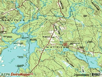
Points of interest:
Notable location: Waltham Volunteer Fire Department (A). Display/hide its location on the map
Cemetery: Hillside Cemetery (1). Display/hide its location on the map
Lakes, reservoirs, and swamps: Little Webb Pond (A), Webb Brook (B), Casebottle Heath (C), Morrison Heath (D), Bloxton Meadow (E), Grant Meadow (F), Casebottle Heath (G), Bloxton Meadow (H). Display/hide their locations on the map
Streams, rivers, and creeks: Timber Brook (A), Webb Brook (B), Bloxton Meadow Brook (C), Cook Brook (D), Cyreno Brook (E), Abbott Brook (F). Display/hide their locations on the map
| This town: | 2.4 people |
| Maine: | 2.3 people |
| This town: | 68.7% |
| Whole state: | 62.9% |
| This town: | 12.7% |
| Whole state: | 9.4% |
Likely homosexual households (counted as self-reported same-sex unmarried-partner households)
- Lesbian couples: 0.0% of all households
- Gay men: 1.3% of all households
| This town: | 13.9% |
| Whole state: | 10.9% |
| This town: | 1.8% |
| Whole state: | 4.1% |
For population 15 years and over in Waltham:
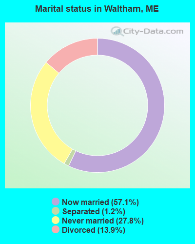
- Never married: 27.8%
- Now married: 57.1%
- Separated: 1.2%
- Widowed: 0.0%
- Divorced: 13.9%
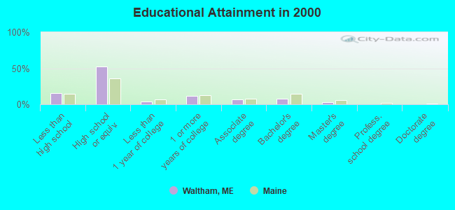
For population 25 years and over in Waltham:
- High school or higher: 84.7%
- Bachelor's degree or higher: 10.4%
- Graduate or professional degree: 3.0%
- Unemployed: 7.2%
- Mean travel time to work (commute): 27.0 minutes
| Here: | 9.1 |
| Maine average: | 11.2 |


Graphs represent county-level data. Detailed 2008 Election Results
Religion statistics for Waltham, ME (based on Hancock County data)


| Religion | Adherents | Congregations |
|---|---|---|
| Mainline Protestant | 4,691 | 58 |
| Catholic | 2,523 | 9 |
| Evangelical Protestant | 1,288 | 23 |
| Other | 820 | 11 |
| None | 45,096 | - |
Food Environment Statistics:
| This county: | 6.01 / 10,000 pop. |
| Maine: | 2.80 / 10,000 pop. |
| This county: | 1.69 / 10,000 pop. |
| Maine: | 2.20 / 10,000 pop. |
| This county: | 4.89 / 10,000 pop. |
| Maine: | 5.75 / 10,000 pop. |
| This county: | 21.61 / 10,000 pop. |
| State: | 11.02 / 10,000 pop. |
| This county: | 7.4% |
| Maine: | 8.2% |
| Hancock County: | 25.4% |
| Maine: | 25.0% |
Strongest AM radio stations in Waltham:
- WDEA (1370 AM; 5 kW; ELLSWORTH, ME; Owner: CUMULUS LICENSING CORP.)
- WZON (620 AM; 5 kW; BANGOR, ME; Owner: THE ZONE CORPORATION)
- WABI (910 AM; 5 kW; BANGOR, ME; Owner: CLEAR CHANNEL BROADCASTING LICENSES, INC.)
- WSKW (1160 AM; 10 kW; SKOWHEGAN, ME; Owner: MOUNTAIN WIRELESS, INCORPORATED)
- WNZS (1340 AM; 1 kW; VEAZIE, ME; Owner: WATERFRONT COMMUNICATIONS INC.)
- WRKO (680 AM; 50 kW; BOSTON, MA; Owner: ENTERCOM BOSTON LICENSE, LLC)
- WEEI (850 AM; 50 kW; BOSTON, MA; Owner: ENTERCOM BOSTON LICENSE, LLC)
- WBZ (1030 AM; 50 kW; BOSTON, MA; Owner: INFINITY BROADCASTING OPERATIONS, INC.)
- WTME (780 AM; 10 kW; RUMFORD, ME; Owner: MOUNTAIN VALLEY BROADCASTING, INC.)
- WCRN (830 AM; 50 kW; WORCESTER, MA; Owner: CARTER BROADCASTING CORPORATION)
- WNNZ (640 AM; 50 kW; WESTFIELD, MA; Owner: CLEAR CHANNEL BROADCASTING LICENSES, INC.)
- WKOX (1200 AM; 50 kW; FRAMINGHAM, MA; Owner: CAPSTAR TX LIMITED PARTNERSHIP)
- WALE (990 AM; 50 kW; GREENVILLE, RI; Owner: NORTH AMERICAN BROADCASTING CO., INC.)
Strongest FM radio stations in Waltham:
- WWMJ (95.7 FM; ELLSWORTH, ME; Owner: CUMULUS LICENSING CORP.)
- WMEH (90.9 FM; BANGOR, ME; Owner: MAINE PUBLIC BROADCASTING CORPORATION)
- WEZQ (92.9 FM; BANGOR, ME; Owner: CUMULUS LICENSING CORP.)
- WNSX (97.7 FM; WINTER HARBOR, ME; Owner: CLEAR CHANNEL BROADCASTING LICENSES, INC.)
- WLKE (99.1 FM; BAR HARBOR, ME; Owner: CLEAR CHANNEL BROADCASTING LICENSES, INC.)
- WHCF (88.5 FM; BANGOR, ME; Owner: BANGOR BAPTIST CHURCH)
- WKIT-FM (100.3 FM; BREWER, ME; Owner: THE ZONE CORPORATION)
- WERU-FM (89.9 FM; BLUE HILL, ME; Owner: SALT POND COMMUNITY B/C COMPANY)
- WBQI (107.7 FM; BAR HARBOR, ME; Owner: MARINER BROADCASTING, L.P.)
- WVOM (103.9 FM; HOWLAND, ME; Owner: CLEAR CHANNEL BROADCASTING LICENSES, INC.)
- WBFB (104.7 FM; BELFAST, ME; Owner: CLEAR CHANNEL BROADCASTING LICENSES, INC.)
- WWBX (97.1 FM; BANGOR, ME; Owner: CLEAR CHANNEL BROADCASTING LICENSES, INC.)
- WFZX (101.7 FM; SEARSPORT, ME; Owner: CLEAR CHANNEL BROADCASTING LICENSES, INC.)
- WBZN (107.3 FM; OLD TOWN, ME; Owner: CUMULUS LICENSING CORP.)
TV broadcast stations around Waltham:
- WMEB-TV (Channel 12; ORONO, ME; Owner: MAINE PUBLIC BROADCASTING CORPORATION)
- W66CL (Channel 66; BANGOR, ME; Owner: MS COMMUNICATIONS, LLC)
- WLBZ (Channel 2; BANGOR, ME; Owner: PACIFIC AND SOUTHERN COMPANY, INC.)
- WBAN-LP (Channel 9; BANGOR, ME; Owner: BANGOR MEDIA GROUP, LLC)
- WVII-TV (Channel 7; BANGOR, ME; Owner: BANGOR COMMUNICATIONS, INC.)
- WBGR-LP (Channel 33; BANGOR/DEDHAM, ME; Owner: MAINE FAMILY BROADCASTING, INC.)
- WCKD-LP (Channel 30; BANGOR/DEDHAM, ME; Owner: J. MCLEOD, ME FAMILY B/CING., INC.)
- WFVX-LP (Channel 22; BANGOR, ME; Owner: ROCKFLEET BROADCASTING III, LLC)
- W39CC (Channel 39; BANGOR, ME; Owner: MS COMMUNICATIONS, LLC)
- W42BZ (Channel 42; BANGOR, ME; Owner: MS COMMUNICATIONS, LLC)
- W50BX (Channel 50; BANGOR, ME; Owner: MS COMMUNICATIONS, LLC)
- W54CG (Channel 54; BANGOR, ME; Owner: MS COMMUNICATIONS, LLC)
- National Bridge Inventory (NBI) Statistics
- 2Number of bridges
- 10ft / 2.6mTotal length
- 1,588Total average daily traffic
- 78Total average daily truck traffic
- 2,434Total future (year 2036) average daily traffic
FCC Registered Antenna Towers:
8 (See the full list of FCC Registered Antenna Towers in Waltham)FCC Registered Microwave Towers:
1- GRAHAM LAKE_USF, Waltham Road (Lat: 44.725250 Lon: -68.333000), Type: Mtower, Structure height: 45.7 m, Overall height: 47.5 m, Call Sign: WQQL209,
Assigned Frequencies: 6019.32 MHz, Grant Date: 12/13/2022, Expiration Date: 01/17/2033, Certifier: Steven T Campbell, Registrant: Wilkinson Barker Knauer, LLP, 1800 M Street Nw, Suite 800n, Washington, DC 20036, Phone: (202) 383-3420, Fax: (202) 783-5851, Email:
FCC Registered Amateur Radio Licenses:
1- Call Sign: KB1KAT, Licensee ID: L00691751, Grant Date: 03/14/2013, Expiration Date: 05/28/2023, Certifier: Barbara J Schroeder, Registrant: Barbara J Schroeder, 970 Waltham Rd, Waltham, ME 04605
FAA Registered Aircraft:
2- Aircraft: AERONCA 7AC (Category: Land, Seats: 2, Weight: Up to 12,499 Pounds, Speed: 90 mph), Engine: CONT MOTOR C90 SERIES (95 HP) (Reciprocating)
N-Number: 1214E, N1214E, N-1214E, Serial Number: 7AC-4772, Year manufactured: 1946, Airworthiness Date: 08/08/2002, Certificate Issue Date: 09/21/2012
Registrant (Individual): Richard C Langhorst, 62 Little Webb Pond Rd, Waltham, ME 04605 - Aircraft: PIPER PA-24-250 (Category: Land, Seats: 4, Weight: Up to 12,499 Pounds, Speed: 135 mph), Engine: LYCOMING 0-540 SERIES (250 HP) (Reciprocating)
N-Number: 5504P, N5504P, N-5504P, Serial Number: 24-567, Year manufactured: 1958, Airworthiness Date: 11/22/1958, Certificate Issue Date: 05/09/1991
Registrant (Individual): Richard C Langhorst, 62 Little Webb Pond Rd, Waltham, ME 04605
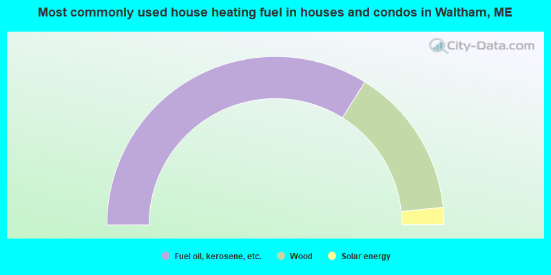
- 67.8%Fuel oil, kerosene, etc.
- 28.9%Wood
- 3.3%Solar energy
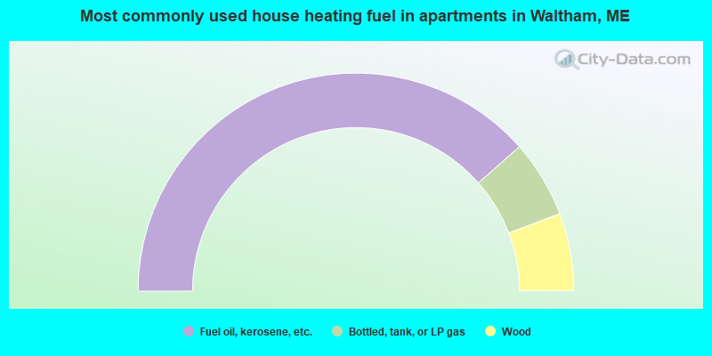
- 76.9%Fuel oil, kerosene, etc.
- 11.5%Bottled, tank, or LP gas
- 11.5%Wood
Waltham compared to Maine state average:
- Unemployed percentage below state average.
- Black race population percentage significantly below state average.
- Hispanic race population percentage significantly below state average.
- Median age above state average.
- Foreign-born population percentage significantly below state average.
- Renting percentage below state average.
- Length of stay since moving in significantly above state average.
- Number of rooms per house significantly below state average.
- House age significantly below state average.
- Percentage of population with a bachelor's degree or higher significantly below state average.