Warwick, Massachusetts
Submit your own pictures of this town and show them to the world
- OSM Map
- General Map
- Google Map
- MSN Map

Population change since 2000: +4.0%
 |
| Males: 389 | |
| Females: 391 |
| Median resident age: | 48.1 years |
| Massachusetts median age: | 39.2 years |
Zip codes: 01378.
| Warwick: | $72,574 |
| MA: | $94,488 |
Estimated per capita income in 2022: $36,419 (it was $19,989 in 2000)
Warwick town income, earnings, and wages data
Estimated median house or condo value in 2022: $292,008 (it was $117,500 in 2000)
| Warwick: | $292,008 |
| MA: | $534,700 |
Mean prices in 2022: all housing units: $313,377; detached houses: $324,224; townhouses or other attached units: $284,225; in 2-unit structures: $287,978; in 3-to-4-unit structures: $183,938; in 5-or-more-unit structures: $249,762; mobile homes: $62,200
Detailed information about poverty and poor residents in Warwick, MA


- 75496.7%White alone
- 81.0%Hispanic
- 70.9%Asian alone
- 70.9%Two or more races
- 40.5%American Indian alone

Races in Warwick detailed stats: ancestries, foreign born residents, place of birth
Full-time law enforcement employees in 2013, including police officers: 2 (2 officers - 2 male; 0 female).
| Officers per 1,000 residents here: | 2.57 |
| Massachusetts average: | 2.51 |
 Recent articles from our blog. Our writers, many of them Ph.D. graduates or candidates, create easy-to-read articles on a wide variety of topics.


 | 2023 Real Estate Observations (5278 replies) |
| MA is Snobby (321 replies) |
| WFH in MA (207 replies) |
| Nightlife in Boston (261 replies) |
| MA 2022 Question 1 (258 replies) |
| Newton on alert after triple homicide (92 replies) |
Latest news from Warwick, MA collected exclusively by city-data.com from local newspapers, TV, and radio stations
Ancestries: English (24.0%), French (16.8%), Irish (15.3%), German (8.5%), Polish (6.9%), Italian (6.8%).
Current Local Time: EST time zone
Incorporated in 1763
Elevation: 937 feet
Land area: 37.3 square miles.
Population density: 21 people per square mile (very low).

4 residents are foreign born
| This town: | 0.5% |
| Massachusetts: | 12.2% |
| Warwick town: | 1.4% ($1,665) |
| Massachusetts: | 1.3% ($2,336) |
Nearest city with pop. 50,000+: Chicopee, MA  (36.9 miles , pop. 54,653).
Nearest city with pop. 200,000+: Boston, MA (67.5 miles , pop. 589,141).
Nearest city with pop. 1,000,000+: Bronx, NY (149.0 miles , pop. 1,332,650).
Nearest cities:
), ), )Latitude: 42.67 N, Longitude: 72.33 W


Single-family new house construction building permits:
- 2007: 1 building, cost: $60,000
- 2006: 2 buildings, average cost: $60,500
- 2005: 4 buildings, average cost: $177,500
- 2004: 4 buildings, average cost: $85,200
- 2003: 4 buildings, average cost: $85,200
- 2002: 1 building, cost: $82,500
- 2001: 2 buildings, average cost: $82,500
- 2000: 3 buildings, average cost: $82,500
- 1999: 3 buildings, average cost: $82,500
- 1998: 3 buildings, average cost: $82,500
- 1997: 4 buildings, average cost: $90,700


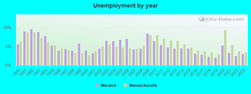
| Here: | 3.1% |
| Massachusetts: | 3.5% |
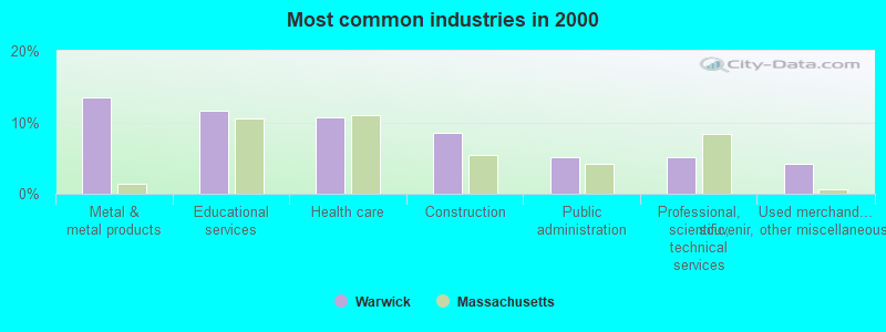
- Metal & metal products (13.6%)
- Educational services (11.6%)
- Health care (10.7%)
- Construction (8.5%)
- Public administration (5.1%)
- Professional, scientific, technical services (5.1%)
- Used merchandise, gift, novelty, souvenir, other miscellaneous stores (4.2%)
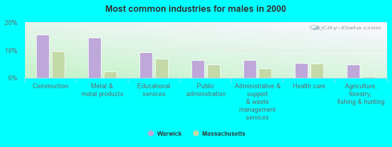
- Construction (15.6%)
- Metal & metal products (14.5%)
- Educational services (9.1%)
- Public administration (6.5%)
- Administrative & support & waste management services (6.5%)
- Health care (5.4%)
- Agriculture, forestry, fishing & hunting (4.8%)
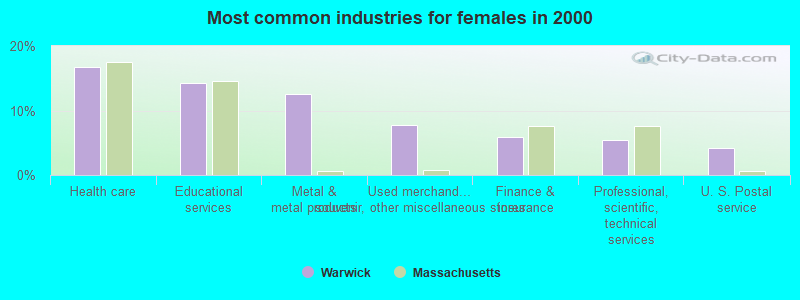
- Health care (16.7%)
- Educational services (14.3%)
- Metal & metal products (12.5%)
- Used merchandise, gift, novelty, souvenir, other miscellaneous stores (7.7%)
- Finance & insurance (6.0%)
- Professional, scientific, technical services (5.4%)
- U. S. Postal service (4.2%)
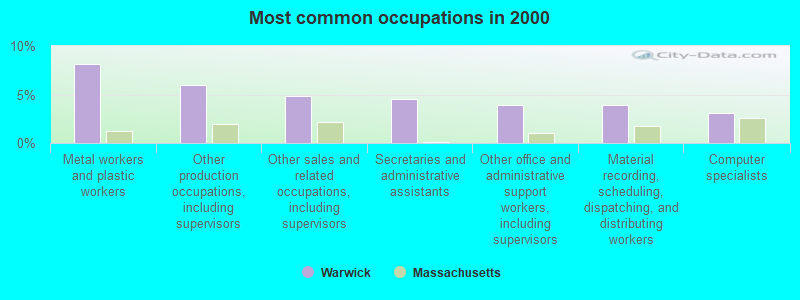
- Metal workers and plastic workers (8.2%)
- Other production occupations, including supervisors (5.9%)
- Other sales and related occupations, including supervisors (4.8%)
- Secretaries and administrative assistants (4.5%)
- Other office and administrative support workers, including supervisors (4.0%)
- Material recording, scheduling, dispatching, and distributing workers (4.0%)
- Computer specialists (3.1%)
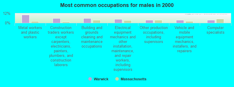
- Metal workers and plastic workers (10.2%)
- Construction traders workers except carpenters, electricians, painters, plumbers, and construction laborers (5.9%)
- Building and grounds cleaning and maintenance occupations (5.9%)
- Electrical equipment mechanics and other installation, maintenance, and repair workers, including supervisors (4.8%)
- Other production occupations, including supervisors (3.8%)
- Vehicle and mobile equipment mechanics, installers, and repairers (3.8%)
- Computer specialists (3.8%)

- Secretaries and administrative assistants (9.5%)
- Other sales and related occupations, including supervisors (8.9%)
- Other production occupations, including supervisors (8.3%)
- Other office and administrative support workers, including supervisors (8.3%)
- Metal workers and plastic workers (6.0%)
- Preschool, kindergarten, elementary, and middle school teachers (4.2%)
- Nursing, psychiatric, and home health aides (4.2%)
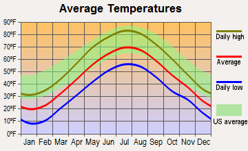
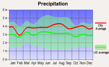
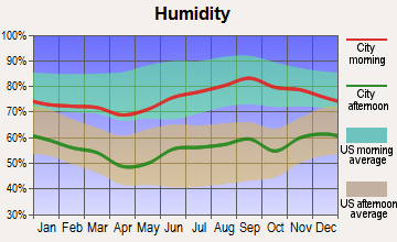
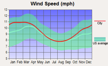
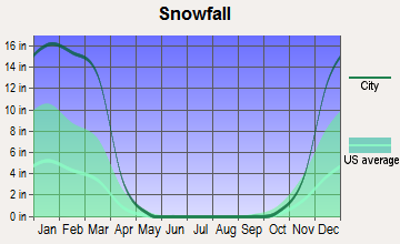
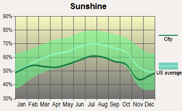
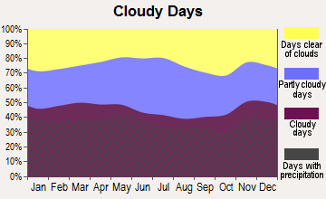
Average climate in Warwick, Massachusetts
Based on data reported by over 4,000 weather stations
(lower is better)
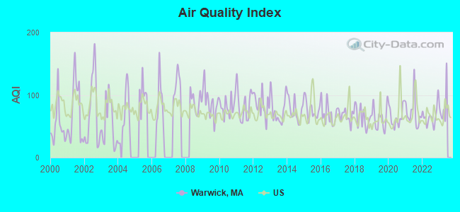
Air Quality Index (AQI) level in 2022 was 65.9. This is about average.
| City: | 65.9 |
| U.S.: | 72.6 |

Sulfur Dioxide (SO2) [ppb] level in 2003 was 3.66. This is significantly worse than average. Closest monitor was 5.1 miles away from the city center.
| City: | 3.66 |
| U.S.: | 1.51 |
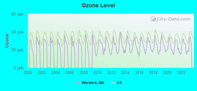
Ozone [ppb] level in 2022 was 23.7. This is significantly better than average. Closest monitor was 12.3 miles away from the city center.
| City: | 23.7 |
| U.S.: | 33.3 |
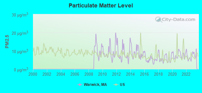
Particulate Matter (PM2.5) [µg/m3] level in 2022 was 6.79. This is about average. Closest monitor was 14.3 miles away from the city center.
| City: | 6.79 |
| U.S.: | 8.11 |
Tornado activity:
Warwick-area historical tornado activity is slightly above Massachusetts state average. It is 15% smaller than the overall U.S. average.
On 6/9/1953, a category F4 (max. wind speeds 207-260 mph) tornado 15.8 miles away from the Warwick town center killed 90 people and injured 1228 people and caused between $50,000,000 and $500,000,000 in damages.
On 6/22/1981, a category F3 (max. wind speeds 158-206 mph) tornado 19.1 miles away from the town center injured 3 people and caused between $5000 and $50,000 in damages.
Earthquake activity:
Warwick-area historical earthquake activity is significantly above Massachusetts state average. It is 70% smaller than the overall U.S. average.On 10/7/1983 at 10:18:46, a magnitude 5.3 (5.1 MB, 5.3 LG, 5.1 ML, Class: Moderate, Intensity: VI - VII) earthquake occurred 134.9 miles away from the city center
On 4/20/2002 at 10:50:47, a magnitude 5.3 (5.3 ML, Depth: 3.0 mi) earthquake occurred 144.9 miles away from Warwick center
On 4/20/2002 at 10:50:47, a magnitude 5.2 (5.2 MB, 4.2 MS, 5.2 MW, 5.0 MW) earthquake occurred 143.9 miles away from Warwick center
On 1/19/1982 at 00:14:42, a magnitude 4.7 (4.5 MB, 4.7 MD, 4.5 LG, Class: Light, Intensity: IV - V) earthquake occurred 68.3 miles away from the city center
On 10/16/2012 at 23:12:25, a magnitude 4.7 (4.7 ML, Depth: 10.0 mi) earthquake occurred 106.1 miles away from the city center
On 10/2/1994 at 11:27:22, a magnitude 3.7 (3.5 LG, 3.7 LG, Depth: 6.2 mi, Class: Light, Intensity: II - III) earthquake occurred 22.3 miles away from the city center
Magnitude types: regional Lg-wave magnitude (LG), body-wave magnitude (MB), duration magnitude (MD), local magnitude (ML), surface-wave magnitude (MS), moment magnitude (MW)
Natural disasters:
The number of natural disasters in Franklin County (20) is greater than the US average (15).Major Disasters (Presidential) Declared: 9
Emergencies Declared: 10
Causes of natural disasters: Floods: 5, Storms: 5, Hurricanes: 4, Snowstorms: 4, Winter Storms: 3, Blizzards: 2, Snows: 2, Snowfall: 1, Tropical Storm: 1, Wind: 1, Other: 1 (Note: some incidents may be assigned to more than one category).

Hospitals and medical centers near Warwick:
- ATHOL MEMORIAL HOME HEALTH AND HOSPICE (Hospital, about 8 miles away; ATHOL, MA)
- APPLEWOOD CARE AND REHABILITATION CENTER (Nursing Home, about 8 miles away; WINCHESTER, NH)
- QUABBIN VALLEY HEALTHCARE (Nursing Home, about 8 miles away; ATHOL, MA)
- ATHOL MEMORIAL HOSPITAL Critical Access Hospitals (about 9 miles away; ATHOL, MA)
- VERNON GREEN NURSING HOME (Nursing Home, about 12 miles away; VERNON, VT)
- TEMPLETON DEVELOPMENTAL CENTER (Hospital, about 13 miles away; BALDWINVILLE, MA)
- OPEN ARMS NURSING HOME INC (Nursing Home, about 14 miles away; WINCHENDON, MA)
Operable nuclear power plant near Warwick:
- 13 miles: Vermont Yankee in Vernon, VT.
Colleges/universities with over 2000 students nearest to Warwick:
- Franklin Pierce University (about 16 miles; Rindge, NH; Full-time enrollment: 2,139)
- Keene State College (about 19 miles; Keene, NH; FT enrollment: 5,098)
- Mount Wachusett Community College (about 19 miles; Gardner, MA; FT enrollment: 3,143)
- University of Massachusetts-Amherst (about 22 miles; Amherst, MA; FT enrollment: 26,583)
- Fitchburg State University (about 28 miles; Fitchburg, MA; FT enrollment: 5,010)
- Smith College (about 29 miles; Northampton, MA; FT enrollment: 3,549)
- Mount Holyoke College (about 31 miles; South Hadley, MA; FT enrollment: 2,573)
Public elementary/middle school in Warwick:
- WARWICK COMMUNITY SCHOOL (Students: 71, Location: 41 WINCHESTER ROAD, Grades: PK-6)
Points of interest:
Notable locations in Warwick: Chase Hill Farm (A), Wagonwheel Campground (B), Warwick Fire Department (C), Warwick Free Public Library (D). Display/hide their locations on the map
Church in Warwick: Trinitarian Congregational Church (A). Display/hide its location on the map
Cemetery: Warwick Cemetery (1). Display/hide its location on the map
Lakes, reservoirs, and swamps: Bent Pond (A), Lily Pond (B), Johnsonian Pond (C), Hastings Pond (D), Wheelers Pond (E), Sheomet Lake (F), Richards Reservoir (G), Richards Mill Pond (H). Display/hide their locations on the map
Streams, rivers, and creeks: Lovers Retreat Brook (A), Black Brook (B), Darling Brook (C), Gales Brook (D), Grace Brook (E), Hodge Brook (F), Kidder Brook (G), Mountain Brook (H), Rum Brook (I). Display/hide their locations on the map
| This town: | 2.4 people |
| Massachusetts: | 2.5 people |
| This town: | 64.4% |
| Whole state: | 63.0% |
| This town: | 11.6% |
| Whole state: | 7.0% |
Likely homosexual households (counted as self-reported same-sex unmarried-partner households)
- Lesbian couples: 0.3% of all households
- Gay men: 0.3% of all households
| This town: | 8.0% |
| Whole state: | 9.3% |
| This town: | 2.0% |
| Whole state: | 4.4% |
For population 15 years and over in Warwick:

- Never married: 23.6%
- Now married: 58.7%
- Separated: 2.5%
- Widowed: 5.1%
- Divorced: 10.1%
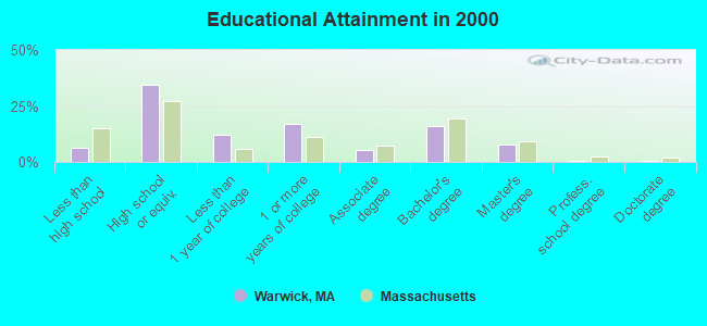
For population 25 years and over in Warwick:
- High school or higher: 93.5%
- Bachelor's degree or higher: 25.0%
- Graduate or professional degree: 8.9%
- Unemployed: 5.1%
- Mean travel time to work (commute): 27.8 minutes
| Here: | 8.8 |
| Massachusetts average: | 13.1 |


Graphs represent county-level data. Detailed 2008 Election Results
Religion statistics for Warwick, MA (based on Franklin County data)


| Religion | Adherents | Congregations |
|---|---|---|
| Catholic | 16,509 | 15 |
| Mainline Protestant | 4,617 | 38 |
| Evangelical Protestant | 2,079 | 20 |
| Other | 1,580 | 21 |
| None | 46,587 | - |
Food Environment Statistics:
| Franklin County: | 3.63 / 10,000 pop. |
| State: | 1.98 / 10,000 pop. |
| Franklin County: | 0.14 / 10,000 pop. |
| Massachusetts: | 0.05 / 10,000 pop. |
| This county: | 1.67 / 10,000 pop. |
| State: | 2.22 / 10,000 pop. |
| This county: | 3.21 / 10,000 pop. |
| Massachusetts: | 1.77 / 10,000 pop. |
| Franklin County: | 8.10 / 10,000 pop. |
| Massachusetts: | 8.76 / 10,000 pop. |
| This county: | 7.5% |
| State: | 8.1% |
| This county: | 22.2% |
| State: | 22.5% |
| Here: | 15.1% |
| State: | 16.5% |
Strongest AM radio stations in Warwick:
- WCAT (700 AM; daytime; 2 kW; ORANGE-ATHOL, MA; Owner: CITADEL BROADCASTING COMPANY)
- WCRN (830 AM; 50 kW; WORCESTER, MA; Owner: CARTER BROADCASTING CORPORATION)
- WNNZ (640 AM; 50 kW; WESTFIELD, MA; Owner: CLEAR CHANNEL BROADCASTING LICENSES, INC.)
- WVNE (760 AM; daytime; 25 kW; LEICESTER, MA; Owner: BLOUNT MASSCOM, INC.)
- WIZZ (1520 AM; daytime; 10 kW; GREENFIELD, MA; Owner: P. & M. RADIO, LLC)
- WRKO (680 AM; 50 kW; BOSTON, MA; Owner: ENTERCOM BOSTON LICENSE, LLC)
- WEEI (850 AM; 50 kW; BOSTON, MA; Owner: ENTERCOM BOSTON LICENSE, LLC)
- WKOX (1200 AM; 50 kW; FRAMINGHAM, MA; Owner: CAPSTAR TX LIMITED PARTNERSHIP)
- WBIX (1060 AM; 40 kW; NATICK, MA; Owner: LANGER BROADCASTING CORPORATION)
- WALE (990 AM; 50 kW; GREENVILLE, RI; Owner: NORTH AMERICAN BROADCASTING CO., INC.)
- WTIC (1080 AM; 50 kW; HARTFORD, CT; Owner: INFINITY RADIO OPERATIONS INC.)
- WKBK (1290 AM; 5 kW; KEENE, NH; Owner: SAGA COMMUNICATIONS OF NEW ENGLAND, LLC)
- WAMG (890 AM; 25 kW; DEDHAM, MA; Owner: MEGA COMMUNICATIONS OF DEDHAM LICENSEE, LLC)
Strongest FM radio stations in Warwick:
- WJDF (97.3 FM; ORANGE, MA; Owner: DEANE BROTHERS BROADCASTING CORP.)
- WYRY (104.9 FM; HINSDALE, NH; Owner: TRI-VALLEY BROADCASTING CORPORATION)
- WOQL (98.7 FM; WINCHESTER, NH; Owner: SAGA COMMUNICATIONS OF NEW HAMPSHIRE, LLC)
- WPVQ (95.3 FM; GREENFIELD, MA; Owner: GREAT NORTHERN RADIO, L.L.C.)
- WFEX (92.1 FM; PETERBOROUGH, NH; Owner: FNX BROADCASTING OF NEW HAMPSHIRE LLC)
- WAHL (99.9 FM; ATHOL, MA; Owner: CITADEL BROADCASTING COMPANY)
- WFCR (88.5 FM; AMHERST, MA; Owner: UNIVERSITY OF MASSACHUSETTS)
- WKNE (103.7 FM; KEENE, NH; Owner: SAGA COMMUNICATIONS OF NEW ENGLAND, LLC)
- WAMC-FM (90.3 FM; ALBANY, NY; Owner: WAMC)
- WEQX (102.7 FM; MANCHESTER, VT; Owner: NORTHSHIRE COMMUNICATIONS, INC.)
- W293AB (106.5 FM; KEENE, NH; Owner: GREAT NORTHERN RADIO, L.L.C.)
- WEVN (90.7 FM; KEENE, NH; Owner: NEW HAMPSHIRE PUBLIC RADIO, INC.)
- WVAY (100.7 FM; WILMINGTON, VT; Owner: GREAT NORTHERN RADIO, L.L.C.)
- WJAN (95.1 FM; SUNDERLAND, VT; Owner: 6 JOHNSON ROAD LICENSES, INC.)
- WHDQ (106.1 FM; CLAREMONT, NH; Owner: GREAT NORTHERN RADIO, L.L.C.)
- WRSY (101.5 FM; MARLBORO, VT; Owner: GREAT NORTHERN RADIO, L.L.C.)
- WAMH (89.3 FM; AMHERST, MA; Owner: TRUSTEES OF AMHERST COLLEGE)
- WINQ (97.7 FM; WINCHENDON, MA; Owner: SAGA COMMUNICATIONS OF NEW ENGLAND, LLC)
- WHAI (98.3 FM; GREENFIELD, MA; Owner: SAGA COMMUNICATIONS OF NEW ENGLAND, LLC)
- WVPR (89.5 FM; WINDSOR, VT; Owner: VERMONT PUBLIC RADIO)
TV broadcast stations around Warwick:
- WUNI (Channel 27; WORCESTER, MA; Owner: ENTRAVISION HOLDINGS, LLC)
- WYDN (Channel 48; WORCESTER, MA; Owner: EDUCATIONAL PUBLIC TV CORPORATION)
- WUTF (Channel 66; MARLBOROUGH, MA; Owner: TELEFUTURA BOSTON LLC)
- WEKW-TV (Channel 52; KEENE, NH; Owner: UNIVERSITY OF NEW HAMPSHIRE)
Warwick fatal accident list:
Apr 19, 2015 04:13 PM, East Wilson Road, Lat: 77.777700, Lon: 777.777700, Vehicles: 1, Persons: 1, Fatalities: 1
Sep 1, 2002 10:00 PM, Sr-78, Vehicles: 1, Persons: 1, Fatalities: 1, Drunk persons involved: 1
- National Bridge Inventory (NBI) Statistics
- 3Number of bridges
- 10ft / 3.4mTotal length
- $1,521,000Total costs
- 1,903Total average daily traffic
- 153Total average daily truck traffic
- 5,379Total future (year 2032) average daily traffic
FCC Registered Antenna Towers:
1- 540 Airport Road (Lat: 41.732778 Lon: -71.423611), Type: 15.5, Overall height: 15.5 m, Registrant: Omnipoint Communications Mb Operations, Inc., East -Providence, Phone: (401) 588-5638
FCC Registered Broadcast Land Mobile Towers:
3- Warwick Fire Sta Rt78&hstngs Pond (Lat: 42.680083 Lon: -72.337583), Call Sign: KWV807, Licensee ID: L00072042,
Assigned Frequencies: 33.4800 MHz, 33.5400 MHz, Grant Date: 03/16/2000, Expiration Date: 03/26/2005, Cancellation Date: 05/28/2005, Registrant: Warwick, Town Of, 1 Hastings Pond Rd, Warwick, MA 01378, Phone: (508) 544-3314
- Fire Station (Lat: 42.680083 Lon: -72.337583), Call Sign: KNGP421, Licensee ID: L00072042,
Assigned Frequencies: 33.0600 MHz, Grant Date: 03/25/1998, Expiration Date: 05/11/2003, Cancellation Date: 08/10/2003, Registrant: Warwick, Town Of, Winchester Rd, Warwick, MA 01378
- Fire Tower Mt Grace (Lat: 42.690833 Lon: -72.354167), Type: Tower, Structure height: 20 m, Call Sign: KNDE690,
Assigned Frequencies: 42.4000 MHz, 42.4400 MHz, Grant Date: 04/06/2022, Expiration Date: 06/05/2032, Registrant: Massachusetts, Commonwealth Of Department Of State Police, 470 Worcester Rd, Framingham, MA 01702, Phone: (508) 820-2222, Email:
FCC Registered Microwave Towers:
14 (See the full list of FCC Registered Microwave Towers in this town)FCC Registered Amateur Radio Licenses:
7- Call Sign: KB1DRD, Licensee ID: L00248500, Grant Date: 06/23/1999, Expiration Date: 02/03/2009, Cancellation Date: 02/04/2011, Registrant: Ingeborg Petschik, 425 Winchester Rd, Warwick, MA 01378
- Call Sign: N1LXO, Grant Date: 04/07/1992, Expiration Date: 04/07/2002, Cancellation Date: 04/08/2004, Registrant: Stanley E Thompson, 371 Wendell Rd, Warwick, MA 01364
- Call Sign: WB1CWH, Licensee ID: L00390439, Grant Date: 08/18/2017, Expiration Date: 11/13/2027, Certifier: Edward W Lemon Jr, Registrant: Edward W Lemon Jr, 700 Old Winchester Rd, Warwick, MA 01378
- Call Sign: KB1VPO, Licensee ID: L01633868, Grant Date: 04/25/2011, Expiration Date: 04/25/2021, Cancellation Date: 04/26/2023, Certifier: Lucinda R Seago, Registrant: Lucinda R Seago, 405 Richmond Rd, Warwick, MA 01378
- Call Sign: AB1SB, Licensee ID: L01740091, Grant Date: 10/16/2012, Expiration Date: 10/16/2022, Certifier: Scott W Seago, Registrant: Scott W Seago, 405 Richmond Rd, Warwick, MA 01378
- Call Sign: KC1EJI, Licensee ID: L01968685, Grant Date: 09/10/2015, Expiration Date: 09/10/2025, Certifier: Adam W Holloway, Registrant: Adam W Holloway, 437 Orange Road, Warwick, MA 01378
- Call Sign: KC1ONF, Licensee ID: L02383879, Grant Date: 01/25/2021, Expiration Date: 01/25/2031, Certifier: Stephen Levin, Registrant: Stephen Levin, 31 Royalston Rd, Warwick, MA 01378-7805
FAA Registered Aircraft:
1- Aircraft: CESSNA 120 (Category: Land, Seats: 2, Weight: Up to 12,499 Pounds, Speed: 90 mph), Engine: CONT MOTOR C85 SERIES (85 HP) (Reciprocating)
N-Number: 89809, N89809, N-89809, Serial Number: 8858, Airworthiness Date: 04/28/1960, Certificate Issue Date: 11/04/2020
Registrant (Individual): John L Roske, 65 Orange Rd, Warwick, MA 01378
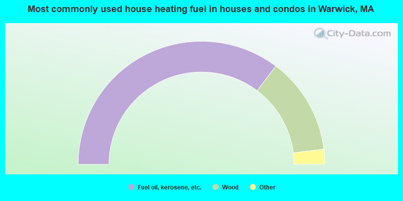
- 70.6%Fuel oil, kerosene, etc.
- 25.5%Wood
- 2.4%Electricity
- 0.8%Utility gas
- 0.8%Coal or coke

- 36.1%Fuel oil, kerosene, etc.
- 30.6%Wood
- 27.8%Electricity
- 5.6%Bottled, tank, or LP gas
Warwick compared to Massachusetts state average:
- Median house value below state average.
- Unemployed percentage below state average.
- Black race population percentage significantly below state average.
- Hispanic race population percentage significantly below state average.
- Median age significantly above state average.
- Foreign-born population percentage significantly below state average.
- Renting percentage significantly below state average.
- Length of stay since moving in significantly above state average.
- Number of rooms per house significantly below state average.
- House age significantly below state average.
- Number of college students below state average.

|
Total of 18 patent applications in 2008-2024.