Waterville, Wisconsin
Submit your own pictures of this town and show them to the world
- OSM Map
- General Map
- Google Map
- MSN Map

Population change since 2000: -3.3%
 |
| Males: 449 | |
| Females: 382 |
| Median resident age: | 42.8 years |
| Wisconsin median age: | 42.6 years |
Zip codes: 54721.
| Waterville: | $68,819 |
| WI: | $70,996 |
Estimated per capita income in 2022: $32,835 (it was $15,482 in 2000)
Waterville town income, earnings, and wages data
Estimated median house or condo value in 2022: $154,284 (it was $66,300 in 2000)
| Waterville: | $154,284 |
| WI: | $252,800 |
Mean prices in 2022: all housing units: $221,909; detached houses: $229,655; townhouses or other attached units: $146,261; in 2-unit structures: $411,353; in 3-to-4-unit structures: $202,301; in 5-or-more-unit structures: $316,881; mobile homes: $45,143
Detailed information about poverty and poor residents in Waterville, WI


- 82098.7%White alone
- 40.5%Hispanic
- 30.4%Two or more races
- 20.2%Asian alone
- 10.1%Black alone
- 10.1%Other race alone

Races in Waterville detailed stats: ancestries, foreign born residents, place of birth
 Recent articles from our blog. Our writers, many of them Ph.D. graduates or candidates, create easy-to-read articles on a wide variety of topics.


 | Can someone tell me nicest/prettiest parts of Waukesha & Brookfield? (7 replies) |
| Wife wants to leave NC to go home... smart??? (22 replies) |
| Considering Wisconsin (29 replies) |
Latest news from Waterville, WI collected exclusively by city-data.com from local newspapers, TV, and radio stations
Ancestries: German (50.3%), Norwegian (12.1%), Irish (10.2%), French (7.9%), English (7.6%), United States (5.9%).
Current Local Time: CST time zone
Elevation: 895 feet
Land area: 35.7 square miles.
Population density: 23 people per square mile (very low).

| Waterville town: | 1.7% ($1,158) |
| Wisconsin: | 2.0% ($2,245) |
Nearest city with pop. 50,000+: Eau Claire, WI  (30.1 miles , pop. 61,704).
Nearest city with pop. 200,000+: St. Paul, MN (56.2 miles , pop. 287,151).
Nearest city with pop. 1,000,000+: Chicago, IL (293.6 miles , pop. 2,896,016).
Nearest cities:
), ), ), Latitude: 44.64 N, Longitude: 92.06 W
Area code commonly used in this area: 715


Single-family new house construction building permits:
- 2022: 5 buildings, average cost: $273,300
- 2021: 3 buildings, average cost: $244,800
- 2020: 3 buildings, average cost: $237,700
- 2019: 2 buildings, average cost: $270,700
- 2018: 1 building, cost: $214,500
- 2015: 1 building, cost: $275,000
- 2014: 2 buildings, average cost: $280,000
- 2013: 2 buildings, average cost: $930,000


| Here: | 3.1% |
| Wisconsin: | 2.7% |

- Agriculture, forestry, fishing & hunting (24.1%)
- Health care (9.6%)
- Accommodation & food services (6.0%)
- Construction (4.5%)
- Food (4.3%)
- Metal & metal products (4.1%)
- Food & beverage stores (3.6%)

- Agriculture, forestry, fishing & hunting (35.1%)
- Construction (7.1%)
- Food (6.7%)
- Metal & metal products (6.3%)
- Motor vehicle & parts dealers (4.1%)
- Repair & maintenance (3.7%)
- Accommodation & food services (3.7%)

- Health care (20.0%)
- Agriculture, forestry, fishing & hunting (9.5%)
- Accommodation & food services (9.0%)
- Food & beverage stores (7.5%)
- Finance & insurance (5.5%)
- Educational services (5.0%)
- Personal & laundry services (4.5%)

- Farmers and farm managers (14.1%)
- Other production occupations, including supervisors (6.2%)
- Laborers and material movers, hand (5.3%)
- Agricultural workers, including supervisors (4.5%)
- Driver/sales workers and truck drivers (4.5%)
- Assemblers and fabricators (3.8%)
- Vehicle and mobile equipment mechanics, installers, and repairers (3.4%)

- Farmers and farm managers (22.0%)
- Other production occupations, including supervisors (7.8%)
- Driver/sales workers and truck drivers (6.7%)
- Laborers and material movers, hand (6.3%)
- Vehicle and mobile equipment mechanics, installers, and repairers (6.0%)
- Agricultural workers, including supervisors (6.0%)
- Metal workers and plastic workers (5.2%)

- Assemblers and fabricators (6.0%)
- Nursing, psychiatric, and home health aides (5.5%)
- Other office and administrative support workers, including supervisors (5.5%)
- Laborers and material movers, hand (4.0%)
- Cooks and food preparation workers (4.0%)
- Health technologists and technicians (4.0%)
- Information and record clerks, except customer service representatives (4.0%)
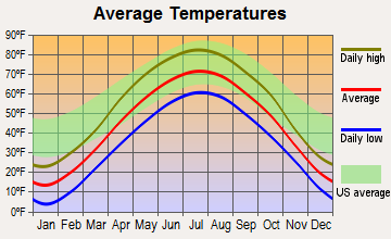
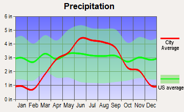
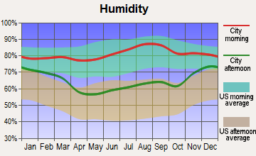
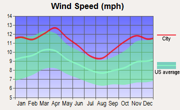
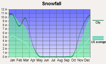
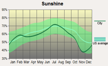
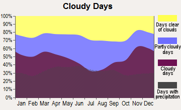
Average climate in Waterville, Wisconsin
Based on data reported by over 4,000 weather stations
Tornado activity:
Waterville-area historical tornado activity is near Wisconsin state average. It is 19% greater than the overall U.S. average.
On 6/4/1958, a category F5 (max. wind speeds 261-318 mph) tornado 22.2 miles away from the Waterville town center killed 21 people and injured 74 people and caused between $5,000,000 and $50,000,000 in damages.
On 9/12/1951, a category F3 (max. wind speeds 158-206 mph) tornado 1.5 miles away from the town center injured one person and caused between $50,000 and $500,000 in damages.
Earthquake activity:
Waterville-area historical earthquake activity is significantly above Wisconsin state average. It is 37% greater than the overall U.S. average.On 7/9/1975 at 14:54:15, a magnitude 4.6 (4.6 MB, Class: Light, Intensity: IV - V) earthquake occurred 206.9 miles away from Waterville center
On 6/5/1993 at 01:24:53, a magnitude 4.1 (4.1 LG, Depth: 6.2 mi) earthquake occurred 218.5 miles away from Waterville center
On 6/28/2004 at 06:10:52, a magnitude 4.2 (4.2 MW, Depth: 6.2 mi) earthquake occurred 271.9 miles away from Waterville center
On 4/18/2008 at 09:36:59, a magnitude 5.4 (5.1 MB, 4.8 MS, 5.4 MW, 5.2 MW, Class: Moderate, Intensity: VI - VII) earthquake occurred 479.4 miles away from the city center
On 3/4/1983 at 06:32:18, a magnitude 4.6 (4.4 MB, 4.6 LG, 4.4 ML) earthquake occurred 364.3 miles away from Waterville center
On 6/10/1987 at 23:48:54, a magnitude 5.1 (4.9 MB, 4.4 MS, 4.6 MS, 5.1 LG) earthquake occurred 456.5 miles away from Waterville center
Magnitude types: regional Lg-wave magnitude (LG), body-wave magnitude (MB), local magnitude (ML), surface-wave magnitude (MS), moment magnitude (MW)
Natural disasters:
The number of natural disasters in Pepin County (12) is smaller than the US average (15).Major Disasters (Presidential) Declared: 10
Emergencies Declared: 2
Causes of natural disasters: Floods: 8, Storms: 6, Tornadoes: 5, Heavy Rains: 2, Drought: 1, Flash Flood: 1, Hurricane: 1, Wind: 1, Other: 1 (Note: some incidents may be assigned to more than one category).
Hospitals and medical centers near Waterville:
Colleges/universities with over 2000 students nearest to Waterville:
- University of Wisconsin-Stout (about 19 miles; Menomonie, WI; Full-time enrollment: 8,120)
- Chippewa Valley Technical College (about 30 miles; Eau Claire, WI; FT enrollment: 4,038)
- University of Wisconsin-Eau Claire (about 30 miles; Eau Claire, WI; FT enrollment: 10,143)
- University of Wisconsin-River Falls (about 32 miles; River Falls, WI; FT enrollment: 5,868)
- Saint Mary's University of Minnesota (about 46 miles; Winona, MN; FT enrollment: 4,022)
- Winona State University (about 47 miles; Winona, MN; FT enrollment: 8,397)
- Rochester Community and Technical College (about 48 miles; Rochester, MN; FT enrollment: 4,444)
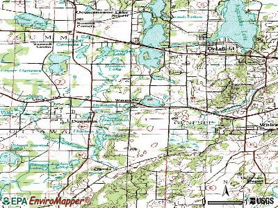
Points of interest:
Church in Waterville: Saint Josephs Church (A). Display/hide its location on the map
Cemeteries: Round Hill Cemetery (1), French Cemetery (2), Saint Josephs Cemetery (3). Display/hide their locations on the map
Lakes: Silver Birch Lake (A), Wilcox Lake (B). Display/hide their locations on the map
Streams, rivers, and creeks: Arkansaw Creek (A), Thompson Slough (B), Eau Galle River (C), Barnes Branch (D). Display/hide their locations on the map
Park in Waterville: Silver Birch Park (1). Display/hide its location on the map
| This town: | 2.4 people |
| Wisconsin: | 2.4 people |
| This town: | 67.0% |
| Whole state: | 64.4% |
| This town: | 5.8% |
| Whole state: | 7.3% |
Likely homosexual households (counted as self-reported same-sex unmarried-partner households)
- Lesbian couples: 0.0% of all households
- Gay men: 0.3% of all households
| This town: | 10.0% |
| Whole state: | 8.7% |
| This town: | 2.2% |
| Whole state: | 3.7% |
For population 15 years and over in Waterville:

- Never married: 24.2%
- Now married: 58.9%
- Separated: 1.0%
- Widowed: 6.5%
- Divorced: 9.4%
For population 25 years and over in Waterville:
- High school or higher: 85.3%
- Bachelor's degree or higher: 8.0%
- Graduate or professional degree: 2.5%
- Unemployed: 3.5%
- Mean travel time to work (commute): 23.2 minutes


| Here: | 8.9 |
| Wisconsin average: | 11.0 |
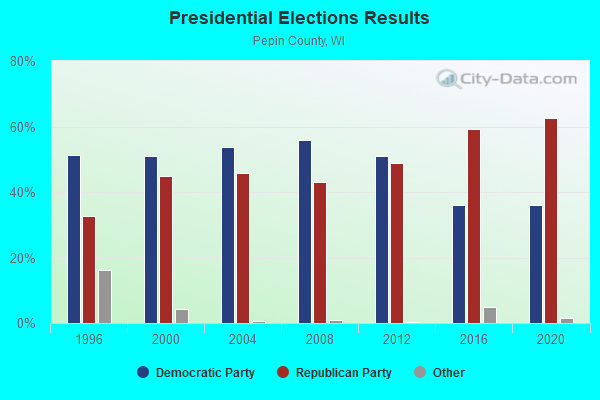
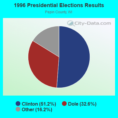
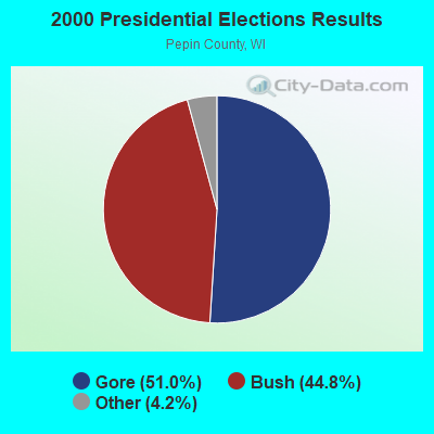

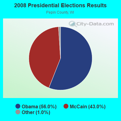
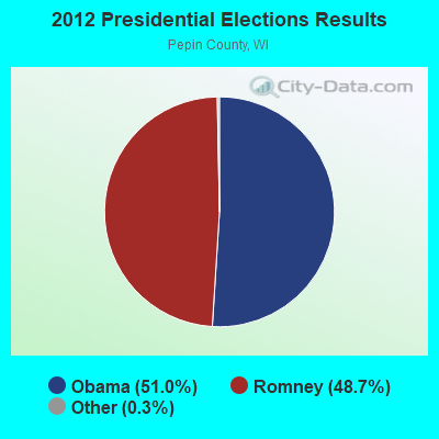
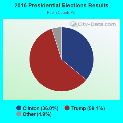
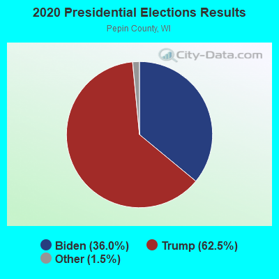
Graphs represent county-level data. Detailed 2008 Election Results
Religion statistics for Waterville, WI (based on Pepin County data)
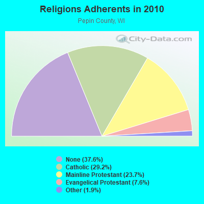
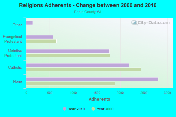
| Religion | Adherents | Congregations |
|---|---|---|
| Catholic | 2,180 | 3 |
| Mainline Protestant | 1,773 | 7 |
| Evangelical Protestant | 568 | 9 |
| Other | 140 | 1 |
| None | 2,808 | - |
Food Environment Statistics:
| This county: | 2.72 / 10,000 pop. |
| Wisconsin: | 1.86 / 10,000 pop. |
| This county: | 5.43 / 10,000 pop. |
| State: | 4.12 / 10,000 pop. |
| This county: | 13.58 / 10,000 pop. |
| Wisconsin: | 8.64 / 10,000 pop. |
| This county: | 8.2% |
| State: | 7.6% |
| This county: | 28.7% |
| Wisconsin: | 27.5% |
| This county: | 15.4% |
| Wisconsin: | 13.0% |
Strongest AM radio stations in Waterville:
- WMEQ (880 AM; 10 kW; MENOMONIE, WI; Owner: CAPSTAR TX LIMITED PARTNERSHIP)
- WCTS (1030 AM; 50 kW; MAPLEWOOD, MN; Owner: CNTL. BAPT. THEO/AL SEMI MINNEAPOLIS)
- WQOQ (1430 AM; 2 kW; DURAND, WI; Owner: ZOE COMMUNICATIONS, INC.)
- KSTP (1500 AM; 50 kW; ST. PAUL, MN; Owner: KSTP-AM, LLC (DELAWARE))
- WCCO (830 AM; 50 kW; MINNEAPOLIS, MN; Owner: INFINITY MEDIA CORPORATION)
- KTIS (900 AM; 25 kW; MINNEAPOLIS, MN; Owner: NORTHWESTERN COLLEGE)
- KFAN (1130 AM; 50 kW; MINNEAPOLIS, MN; Owner: AMFM RADIO LICENSES, L.L.C.)
- WDGY (630 AM; 8 kW; HUDSON, WI; Owner: 630 RADIO, INCORPORATED)
- WAYY (790 AM; 5 kW; EAU CLAIRE, WI; Owner: MAVERICK MEDIA OF EAU CLAIRE LICENSE LLC)
- WEBC (560 AM; 50 kW; DULUTH, MN)
- WSPT (1010 AM; 50 kW; STEVENS POINT, WI)
- WEAQ (1150 AM; 5 kW; CHIPPEWA FALLS, WI; Owner: MAVERICK MEDIA OF EAU CLAIRE LICENSE LLC)
- KOLM (1520 AM; 10 kW; ROCHESTER, MN; Owner: OLMSTED COUNTY BROADCASTING COMPANY)
Strongest FM radio stations in Waterville:
- WDMO (95.9 FM; DURAND, WI; Owner: ZOE COMMUNICATIONS, INC.)
- KWNG (105.9 FM; RED WING, MN; Owner: SORENSON BROADCASTING CORPORATION)
- W211AY (90.1 FM; MENOMONIE, WI; Owner: CALVARY CHAPEL OF TWIN FALLS, INC.)
- WHWC (88.3 FM; MENOMONIE, WI; Owner: STATE OF WISCONSIN - EDUCATIONAL COMMUNICATIONS BOARD)
- WVSS (90.7 FM; MENOMONIE, WI; Owner: BD. OF REGENTS, UNIVERSITY OF WISCONSIN SYSTEM)
- KMFX-FM (102.5 FM; LAKE CITY, MN; Owner: CLEAR CHANNEL BROADCASTING LICENSES, INC.)
- KLCH (94.9 FM; LAKE CITY, MN; Owner: WAITT RADIO, INC.)
- WAXX (104.5 FM; EAU CLAIRE, WI; Owner: MAVERICK MEDIA OF EAU CLAIRE LICENSE LLC)
- KNXR (97.5 FM; ROCHESTER, MN; Owner: UNITED AUDIO CORPORATION)
- WXPT (104.1 FM; ST. LOUIS PARK, MN; Owner: THE AUDIO HOUSE, INC.)
- WUEC (89.7 FM; EAU CLAIRE, WI; Owner: BOARD OF REGENTS, UNIVERSITY OF WISCONSIN SYSTEM)
- WMEQ-FM (92.1 FM; MENOMONIE, WI; Owner: CAPSTAR TX LIMITED PARTNERSHIP)
- WECL (92.9 FM; ELK MOUND, WI; Owner: MAVERICK MEDIA OF EAU CLAIRE LICENSE LLC)
- WBIZ-FM (100.7 FM; EAU CLAIRE, WI; Owner: CAPSTAR TX LIMITED PARTNERSHIP)
TV broadcast stations around Waterville:
- WHWC-TV (Channel 28; MENOMONIE, WI; Owner: STATE OF WISCONSIN - EDUCATIONAL COMMUNICATIONS BOARD)
- WQOW-TV (Channel 18; EAU CLAIRE, WI; Owner: WXOW-WQOW TELEVISION, INC.)
- WEAU-TV (Channel 13; EAU CLAIRE, WI; Owner: WEAU LICENSEE CORP.)
- WKBT (Channel 8; LA CROSSE, WI; Owner: QUEENB TELEVISION, LLC)
- KXLT-TV (Channel 47; ROCHESTER, MN; Owner: SHOCKLEY BROADCASTING, LLC)
- K57CN (Channel 57; WABASHA, MN; Owner: HUBBARD BROADCASTING, INC.)
- WEUX (Channel 48; CHIPPEWA FALLS, WI; Owner: GRANT MEDIA INC.)
- National Bridge Inventory (NBI) Statistics
- 25Number of bridges
- 148ft / 45.1mTotal length
- $152,000Total costs
- 25,165Total average daily traffic
- 1,689Total average daily truck traffic
- 27,642Total future (year 2039) average daily traffic

- New bridges - historical statistics
- 41930-1939
- 11960-1969
- 31970-1979
- 41980-1989
- 111990-1999
- 22000-2009

- 31.5%Bottled, tank, or LP gas
- 28.5%Utility gas
- 18.1%Wood
- 17.4%Fuel oil, kerosene, etc.
- 4.4%Electricity

- 35.5%Bottled, tank, or LP gas
- 25.8%Fuel oil, kerosene, etc.
- 21.0%Electricity
- 14.5%Utility gas
- 3.2%Wood
Waterville compared to Wisconsin state average:
- Median house value below state average.
- Unemployed percentage significantly below state average.
- Black race population percentage significantly below state average.
- Hispanic race population percentage significantly below state average.
- Foreign-born population percentage significantly below state average.
- Renting percentage below state average.
- Length of stay since moving in significantly above state average.
- Number of rooms per house significantly below state average.
- House age significantly below state average.
- Percentage of population with a bachelor's degree or higher significantly below state average.