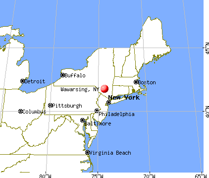
Wawarsing, New York
Submit your own pictures of this town and show them to the world
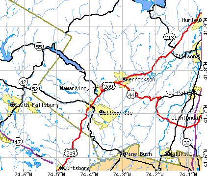
- OSM Map
- General Map
- Google Map
- MSN Map
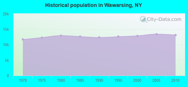
Population change since 2000: +2.1%
 |
| Males: 7,394 | |
| Females: 5,763 |
| Median resident age: | 40.1 years |
| New York median age: | 40.7 years |
Zip codes: 12458.
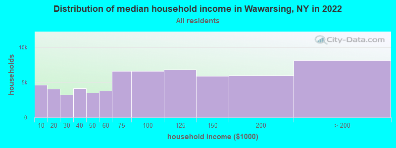
| Wawarsing: | $67,756 |
| NY: | $79,557 |
Estimated per capita income in 2022: $36,379 (it was $16,512 in 2000)
Wawarsing town income, earnings, and wages data
Estimated median house or condo value in 2022: $261,215 (it was $86,400 in 2000)
| Wawarsing: | $261,215 |
| NY: | $400,400 |
Mean prices in 2022: all housing units: $379,181; detached houses: $393,684; townhouses or other attached units: $652,719; in 2-unit structures: $266,147; in 3-to-4-unit structures: $293,759; in 5-or-more-unit structures: $291,039; mobile homes: $115,808
Detailed information about poverty and poor residents in Wawarsing, NY
Compare current foreclosures near Wawarsing, NY:
| Photo | Address | Area | Beds / Baths | Price | Details |
|---|---|---|---|---|---|

|
#1
Alpine Dr
Woodridge, NY 12789
|
1,378 sq. feet
|
2 baths 2 beds |
$275,000
|
show details |

|
#2
State Route 52
Walden, NY 12586
|
2,680 sq. feet
|
2 baths 4 beds |
$449,900
|
show details |

|
#3
Lake Shore Dr E
Rock Hill, NY 12775
|
2,820 sq. feet
|
3 baths 4 beds |
$439,900
|
show details |

|
#4
Brunyswick
New Paltz, NY 12561
|
- sq. feet
|
1 baths 2 beds |
$114,900
|
show details |

|
#5
Orchard St
Walden, NY 12586
|
1,236 sq. feet
|
1 baths 2 beds |
$89,900
|
show details |

|
#6
Watch Hill Rd
New Paltz, NY 12561
|
1,729 sq. feet
|
2 baths 3 beds |
show details | |

|
#7
Scotchtown Collabar Rd
Middletown, NY 10941
|
2,887 sq. feet
|
3 baths 4 beds |
show details | |

|
#8
Alfred Pl
Walden, NY 12586
|
1,544 sq. feet
|
1 baths 3 beds |
show details | |

|
#9
Rd B
Cragsmoor, NY 12420
|
960 sq. feet
|
1 baths 3 beds |
show details | |

|
#10
Tow Path Rd
Accord, NY 12404
|
1,337 sq. feet
|
1 baths 2 beds |
show details |
| Photo | Address | Area | Beds / Baths | Price | Details |
|---|---|---|---|---|---|

|
#11
Route 209
Kerhonkson, NY 12446
|
1,200 sq. feet
|
1 baths 3 beds |
show details | |

|
#12
Sarine Rd
Wurtsboro, NY 12790
|
1,657 sq. feet
|
2 baths 4 beds |
show details | |

|
#13
Birch St
Bloomingburg, NY 12721
|
2,604 sq. feet
|
2 baths 5 beds |
show details | |

|
#14
River Rd
Walden, NY 12586
|
2,534 sq. feet
|
3 baths 3 beds |
show details | |

|
#15
Bruynswick Rd
New Paltz, NY 12561
|
2,380 sq. feet
|
3 baths 3 beds |
show details | |

|
#16
Marc Ln
Wurtsboro, NY 12790
|
1,008 sq. feet
|
2 baths 3 beds |
show details | |

|
#17
County Route 17
Montgomery, NY 12549
|
1,200 sq. feet
|
1 baths 3 beds |
show details | |

|
#18
Grosso Ct
Montgomery, NY 12549
|
2,496 sq. feet
|
2 baths 4 beds |
show details | |

|
#19
Burnt Meadow Rd
Gardiner, NY 12525
|
3,404 sq. feet
|
4 baths 5 beds |
show details | |

|
#20
Myers Rd
Neversink, NY 12765
|
1,728 sq. feet
|
1 baths 5 beds |
show details |
| Photo | Address | Area | Beds / Baths | Price | Details |
|---|---|---|---|---|---|

|
#21
Buck Rd
Accord, NY 12404
|
3,904 sq. feet
|
1 baths 5 beds |
show details | |

|
#22
Dickerson Ave
Montgomery, NY 12549
|
3,102 sq. feet
|
2 baths 4 beds |
show details | |

|
#23
County Road 2
Olivebridge, NY 12461
|
1,575 sq. feet
|
1 baths 3 beds |
show details | |

|
#24
Trail One
Wurtsboro, NY 12790
|
2,644 sq. feet
|
2 baths 7 beds |
show details | |

|
#25
Joshua Dr
Bloomingburg, NY 12721
|
2,320 sq. feet
|
4 baths 4 beds |
show details | |

|
#26
Dunthorne Dr
Bloomingburg, NY 12721
|
2,110 sq. feet
|
1 baths 4 beds |
show details | |

|
#27
Hasbrouck Rd
New Paltz, NY 12561
|
1,812 sq. feet
|
2 baths 3 beds |
show details | |

|
#28
Winding Hill Rd
Montgomery, NY 12549
|
3,006 sq. feet
|
1 baths 5 beds |
show details | |

|
#29
Lippincott Rd
Wallkill, NY 12589
|
2,262 sq. feet
|
3 baths 3 beds |
show details | |

|
#30
Watson Hollow Rd
West Shokan, NY 12494
|
1,768 sq. feet
|
2 baths 3 beds |
show details |
| Photo | Address | Area | Beds / Baths | Price | Details |
|---|---|---|---|---|---|

|
#31
Prosperous Valley Rd
Middletown, NY 10940
|
1,823 sq. feet
|
2 baths 4 beds |
show details | |

|
#32
Capron St
Walden, NY 12586
|
1,464 sq. feet
|
2 baths 3 beds |
show details | |

|
#33
S Ohioville Rd
New Paltz, NY 12561
|
2,064 sq. feet
|
1 baths 4 beds |
show details | |

|
#34
Windy Ridge Rd
Wallkill, NY 12589
|
3,006 sq. feet
|
2 baths 3 beds |
show details | |

|
#35
Pluto Ln
Modena, NY 12548
|
2,950 sq. feet
|
2 baths 4 beds |
show details | |

|
#36
Melissa Ter
Middletown, NY 10941
|
3,266 sq. feet
|
2 baths 4 beds |
show details | |

|
#37
Raymond Ln
New Paltz, NY 12561
|
1,537 sq. feet
|
2 baths 3 beds |
show details | |

|
#38
Twin Island Cir
Walden, NY 12586
|
2,188 sq. feet
|
2 baths 3 beds |
show details | |

|
#39
Wileman Ave
Walden, NY 12586
|
1,152 sq. feet
|
2 baths 4 beds |
show details | |

|
#40
Ulster Ave
Walden, NY 12586
|
3,054 sq. feet
|
2 baths 4 beds |
show details |
| Photo | Address | Area | Beds / Baths | Price | Details |
|---|---|---|---|---|---|

|
#41
Pleasant Ave
Walden, NY 12586
|
1,040 sq. feet
|
1 baths 3 beds |
show details | |

|
#42
State Route 213
High Falls, NY 12440
|
1,248 sq. feet
|
1 baths 3 beds |
show details | |

|
#43
Meadow Ln
Modena, NY 12548
|
936 sq. feet
|
1 baths 2 beds |
show details | |

|
#44
York Ave
Monticello, NY 12701
|
1,602 sq. feet
|
1 baths 3 beds |
show details | |

|
#45
Ivy Hill Rd
Walden, NY 12586
|
1,231 sq. feet
|
1 baths 1 beds |
show details | |

|
#46
Beyers Rd
Montgomery, NY 12549
|
3,889 sq. feet
|
4 baths 4 beds |
show details | |

|
#47
Lincoln Pl
Monticello, NY 12701
|
1,836 sq. feet
|
2 baths 4 beds |
show details | |

|
#48
Hidden Ridge Dr
Monticello, NY 12701
|
1,114 sq. feet
|
2 baths 2 beds |
show details | |

|
#49
Scotty Ter
Circleville, NY 10919
|
1,860 sq. feet
|
2 baths 3 beds |
show details | |

|
Check over 1 million property listings on Foreclosure.com!
|
browse all offers | |||

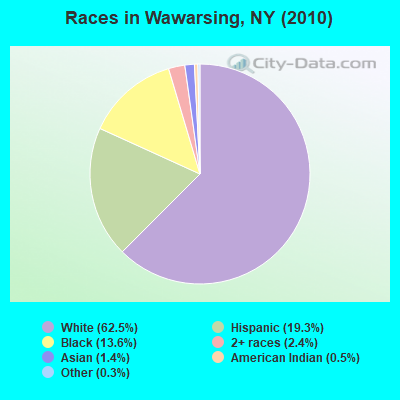
- 8,22962.5%White alone
- 2,53819.3%Hispanic
- 1,78413.6%Black alone
- 3162.4%Two or more races
- 1801.4%Asian alone
- 660.5%American Indian alone
- 420.3%Other race alone
- 20.02%Native Hawaiian and Other
Pacific Islander alone
Races in Wawarsing detailed stats: ancestries, foreign born residents, place of birth
 Recent articles from our blog. Our writers, many of them Ph.D. graduates or candidates, create easy-to-read articles on a wide variety of topics.


 | For those interested in Technology and Economic activity in Upstate NY... (2801 replies) |
| Hispanic/Latino communities in Upstate NY (800 replies) |
| House Upstate (46 replies) |
| Where is Diamond City upstate NY? (65 replies) |
| Liberty, Naponach, Callicoon, Glen Spey. Where should we move (7 replies) |
Latest news from Wawarsing, NY collected exclusively by city-data.com from local newspapers, TV, and radio stations
Ancestries: German (13.6%), Irish (12.5%), Italian (9.5%), United States (7.0%), English (6.1%), Dutch (5.0%).
Current Local Time: EST time zone
Elevation: 288 feet
Land area: 130.7 square miles.
Population density: 101 people per square mile (very low).
1,277 residents are foreign born (4.9% Latin America, 3.8% Europe).
| This town: | 9.9% |
| New York: | 20.4% |
| Wawarsing town: | 2.3% ($1,969) |
| New York: | 1.9% ($2,847) |
Nearest city with pop. 50,000+: Ramapo, NY  (45.8 miles , pop. 108,905).
Nearest city with pop. 200,000+: Bronx, NY (67.6 miles , pop. 1,332,650).
Nearest cities:
), ), ), )Latitude: 41.74 N, Longitude: 74.40 W
Area code commonly used in this area: 845

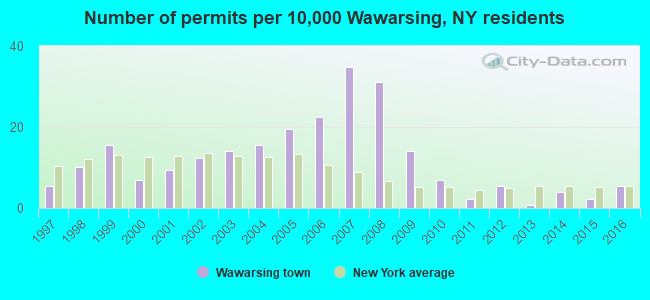
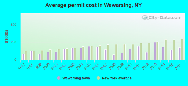
Single-family new house construction building permits:
- 2016: 7 buildings, average cost: $176,400
- 2015: 3 buildings, average cost: $144,300
- 2014: 5 buildings, average cost: $178,700
- 2013: 1 building, cost: $250,000
- 2012: 7 buildings, average cost: $105,400
- 2011: 3 buildings, average cost: $193,000
- 2010: 9 buildings, average cost: $154,800
- 2009: 18 buildings, average cost: $99,300
- 2008: 40 buildings, average cost: $73,000
- 2007: 45 buildings, average cost: $148,600
- 2006: 29 buildings, average cost: $180,100
- 2005: 25 buildings, average cost: $193,300
- 2004: 20 buildings, average cost: $169,400
- 2003: 18 buildings, average cost: $171,400
- 2002: 16 buildings, average cost: $156,900
- 2001: 12 buildings, average cost: $116,000
- 2000: 9 buildings, average cost: $109,800
- 1999: 20 buildings, average cost: $88,200
- 1998: 13 buildings, average cost: $124,800
- 1997: 7 buildings, average cost: $82,100
| Here: | 3.9% |
| New York: | 4.4% |
- Accommodation & food services (10.5%)
- Public administration (9.9%)
- Metal & metal products (8.9%)
- Educational services (8.8%)
- Health care (8.5%)
- Finance & insurance (5.5%)
- Construction (4.9%)
- Accommodation & food services (12.2%)
- Metal & metal products (12.1%)
- Public administration (9.5%)
- Construction (8.5%)
- Health care (4.9%)
- Educational services (4.8%)
- Food & beverage stores (4.3%)
- Educational services (13.5%)
- Health care (12.6%)
- Public administration (10.4%)
- Finance & insurance (9.7%)
- Accommodation & food services (8.5%)
- Social assistance (5.4%)
- Metal & metal products (5.2%)
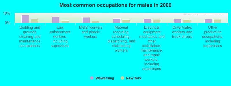
- Building and grounds cleaning and maintenance occupations (6.6%)
- Law enforcement workers, including supervisors (4.4%)
- Other production occupations, including supervisors (4.0%)
- Other office and administrative support workers, including supervisors (3.8%)
- Metal workers and plastic workers (3.7%)
- Material recording, scheduling, dispatching, and distributing workers (3.5%)
- Other management occupations, except farmers and farm managers (3.2%)
- Building and grounds cleaning and maintenance occupations (8.1%)
- Law enforcement workers, including supervisors (6.4%)
- Metal workers and plastic workers (5.9%)
- Material recording, scheduling, dispatching, and distributing workers (4.6%)
- Electrical equipment mechanics and other installation, maintenance, and repair workers, including supervisors (4.2%)
- Driver/sales workers and truck drivers (3.9%)
- Other production occupations, including supervisors (3.8%)
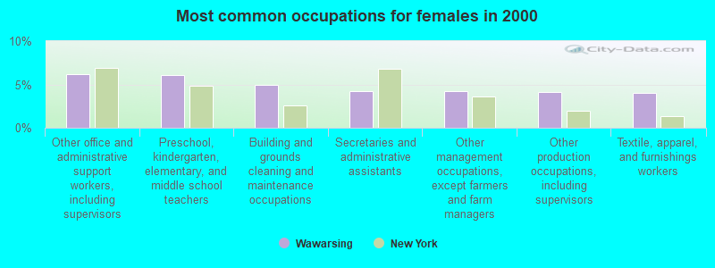
- Other office and administrative support workers, including supervisors (6.2%)
- Preschool, kindergarten, elementary, and middle school teachers (6.1%)
- Building and grounds cleaning and maintenance occupations (4.9%)
- Secretaries and administrative assistants (4.2%)
- Other management occupations, except farmers and farm managers (4.2%)
- Other production occupations, including supervisors (4.1%)
- Textile, apparel, and furnishings workers (4.1%)
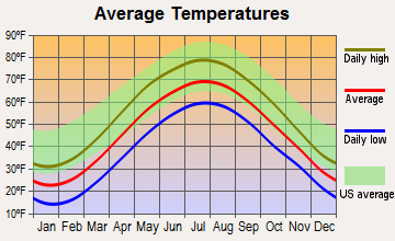
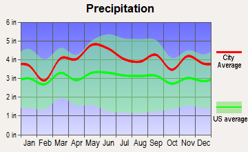
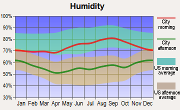
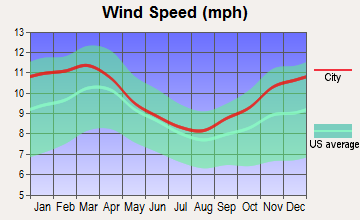
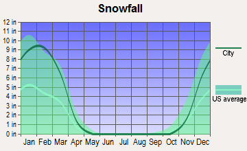
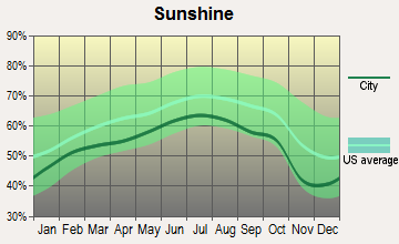
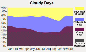
Average climate in Wawarsing, New York
Based on data reported by over 4,000 weather stations
(lower is better)
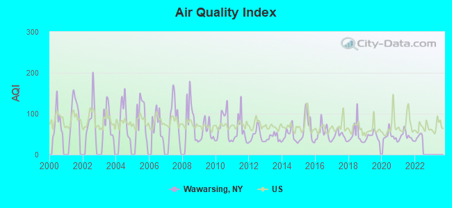
Air Quality Index (AQI) level in 2021 was 44.9. This is significantly better than average.
| City: | 44.9 |
| U.S.: | 72.6 |
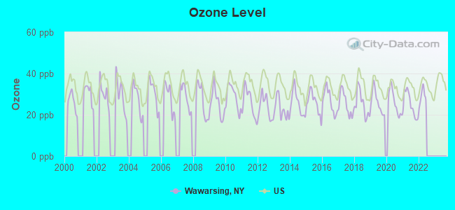
Ozone [ppb] level in 2021 was 24.9. This is better than average. Closest monitor was 17.8 miles away from the city center.
| City: | 24.9 |
| U.S.: | 33.3 |
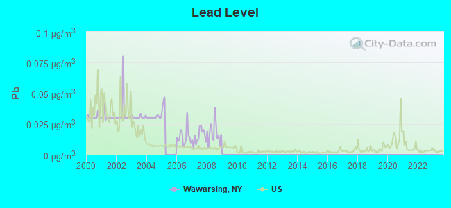
Lead (Pb) [µg/m3] level in 2008 was 0.0178. This is significantly worse than average. Closest monitor was 18.8 miles away from the city center.
| City: | 0.0178 |
| U.S.: | 0.0093 |
Tornado activity:
Wawarsing-area historical tornado activity is above New York state average. It is 41% smaller than the overall U.S. average.
On 7/14/1988, a category F3 (max. wind speeds 158-206 mph) tornado 28.6 miles away from the Wawarsing town center injured one person and caused between $500,000 and $5,000,000 in damages.
On 7/10/1989, a category F4 (max. wind speeds 207-260 mph) tornado 48.1 miles away from the town center injured 20 people and caused between $5,000,000 and $50,000,000 in damages.
Earthquake activity:
Wawarsing-area historical earthquake activity is significantly above New York state average. It is 67% smaller than the overall U.S. average.On 10/7/1983 at 10:18:46, a magnitude 5.3 (5.1 MB, 5.3 LG, 5.1 ML, Class: Moderate, Intensity: VI - VII) earthquake occurred 153.1 miles away from the city center
On 4/20/2002 at 10:50:47, a magnitude 5.3 (5.3 ML, Depth: 3.0 mi) earthquake occurred 195.0 miles away from the city center
On 4/20/2002 at 10:50:47, a magnitude 5.2 (5.2 MB, 4.2 MS, 5.2 MW, 5.0 MW) earthquake occurred 193.1 miles away from the city center
On 8/23/2011 at 17:51:04, a magnitude 5.8 (5.8 MW, Depth: 3.7 mi) earthquake occurred 324.7 miles away from Wawarsing center
On 1/16/1994 at 01:49:16, a magnitude 4.6 (4.6 MB, 4.6 LG, Depth: 3.1 mi, Class: Light, Intensity: IV - V) earthquake occurred 129.7 miles away from the city center
On 6/17/1991 at 08:53:16, a magnitude 4.1 (4.0 MB, 4.0 LG, Depth: 3.1 mi) earthquake occurred 63.2 miles away from the city center
Magnitude types: regional Lg-wave magnitude (LG), body-wave magnitude (MB), local magnitude (ML), surface-wave magnitude (MS), moment magnitude (MW)
Natural disasters:
The number of natural disasters in Ulster County (32) is a lot greater than the US average (15).Major Disasters (Presidential) Declared: 23
Emergencies Declared: 8
Causes of natural disasters: Floods: 12, Storms: 12, Hurricanes: 6, Snowstorms: 3, Blizzards: 2, Tropical Storms: 2, Power Outage: 1, Tornado: 1, Tropical Depression: 1, Water Shortage: 1, Wind: 1, Winter Storm: 1, Other: 3 (Note: some incidents may be assigned to more than one category).

Hospitals and medical centers near Wawarsing:
- UCPA OF ULSTER COUNTY (Hospital, about 14 miles away; NEW PALTZ, NY)
- THE MOUNTAIN VIEW NURSING AND REHAB CENTRE (Nursing Home, about 16 miles away; NEW PALTZ, NY)
- HOSPICE OF SULLIVAN COUNTY INC (Hospital, about 16 miles away; MONTICELLO, NY)
- MONTGOMERY NURSING AND REHABILITATION CENTER (Nursing Home, about 16 miles away; MONTGOMERY, NY)
Colleges/universities with over 2000 students nearest to Wawarsing:
- Ulster County Community College (about 17 miles; Stone Ridge, NY; Full-time enrollment: 2,207)
- State University of New York at New Paltz (about 17 miles; New Paltz, NY; FT enrollment: 7,319)
- Orange County Community College (about 21 miles; Middletown, NY; FT enrollment: 4,742)
- Marist College (about 25 miles; Poughkeepsie, NY; FT enrollment: 5,536)
- Culinary Institute of America (about 25 miles; Hyde Park, NY; FT enrollment: 3,869)
- Mount Saint Mary College (about 26 miles; Newburgh, NY; FT enrollment: 2,166)
- Dutchess Community College (about 26 miles; Poughkeepsie, NY; FT enrollment: 6,554)
Private high school in Wawarsing:
- WAWARSING CHRISTIAN ACADEMY (Students: 78, Location: 7227 ROUTE 209, Grades: PK-12)
Points of interest:
Notable locations in Wawarsing: Burd Farm (A), August Farm (B), Escot Valley Farm (C), Laughing Duck Farm (D), Norwegian Wood Farm (E), One Earth Farm (F), Rusty Plough Farm (G), Shawangunk Country Club (H), Nevele Grande Country Club (I), Camp Laurel (J), Frank Utter Colony Farm (K), Sunrise Manor (L), Yama Hills Farm (M), Hunt Memorial Building (N), Pioneer Engine Company (O), Norbury Hall (P), Shadowland Theatre (Q), Scoresby Hose Hook and Ladder Company (R), Kimble Hose Company Number 2 (S), Ellenville Public Library (T). Display/hide their locations on the map
Churches in Wawarsing include: Don Bosco Church (A), Community Bible Church (B), Ellenville Assembly of God (C), Kingdom Hall of Jehovahs Witnesses (D), Praise Dominion Family Worship Center (E), Seventh Day Adventist Church (F), Ukrainian Catholic Church (G), Federated Church of Kerhonkson (H), Saint Paul African Methodist Episcopal Zion Church (I). Display/hide their locations on the map
Cemeteries: Furman Cemetery (1), Fantine Cemetery (2). Display/hide their locations on the map
Lakes, reservoirs, and swamps: Lyon Lake (A), Lake Maratanza (B), Mud Pond (C), Ulster Heights Lake (D), Windsor Lake (E), Lake Awosting (F), Cranberry Lake (G), Cape Pond (H). Display/hide their locations on the map
Streams, rivers, and creeks: Trout Creek (A), Mine Hole Brook (B), Fly Brook (C), Fantine Kill (D), Brandy Brook (E), South Gully (F), Botsford Brook (G), Sandburg Creek (H), Vernooy Kill (I). Display/hide their locations on the map
Park in Wawarsing: Liberty Square (1). Display/hide its location on the map
| This town: | 2.5 people |
| New York: | 2.6 people |
| This town: | 65.3% |
| Whole state: | 63.5% |
| This town: | 11.1% |
| Whole state: | 6.8% |
Likely homosexual households (counted as self-reported same-sex unmarried-partner households)
- Lesbian couples: 0.6% of all households
- Gay men: 0.4% of all households
| This town: | 19.1% |
| Whole state: | 14.6% |
| This town: | 8.4% |
| Whole state: | 7.4% |
People in group quarters in Wawarsing in 2010:
- 1,723 people in state prisons
- 284 people in residential treatment centers for adults
- 30 people in group homes intended for adults
- 24 people in emergency and transitional shelters (with sleeping facilities) for people experiencing homelessness
- 5 people in group homes for juveniles (non-correctional)
People in group quarters in Wawarsing in 2000:
- 1,195 people in state prisons
- 319 people in homes or halfway houses for drug/alcohol abuse
- 105 people in other noninstitutional group quarters
- 26 people in homes for the mentally retarded
- 3 people in other group homes
For population 15 years and over in Wawarsing:
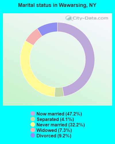
- Never married: 32.2%
- Now married: 47.2%
- Separated: 4.1%
- Widowed: 7.3%
- Divorced: 9.2%
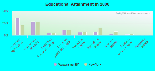
For population 25 years and over in Wawarsing:
- High school or higher: 64.6%
- Bachelor's degree or higher: 13.5%
- Graduate or professional degree: 6.3%
- Unemployed: 6.6%
- Mean travel time to work (commute): 26.1 minutes
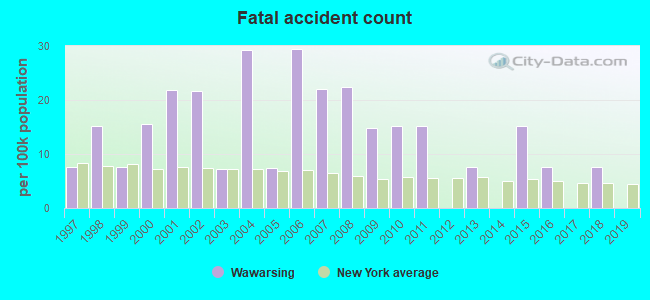
| Here: | 15.8 |
| New York average: | 14.2 |
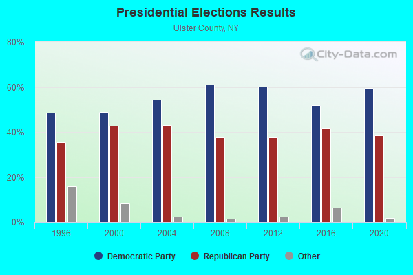
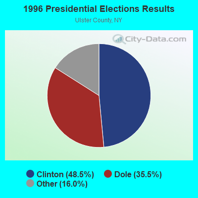
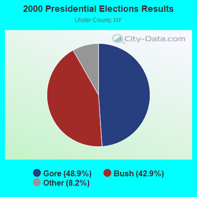
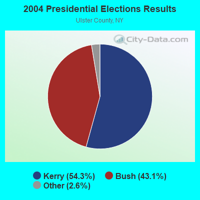
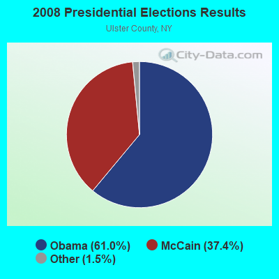

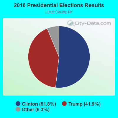
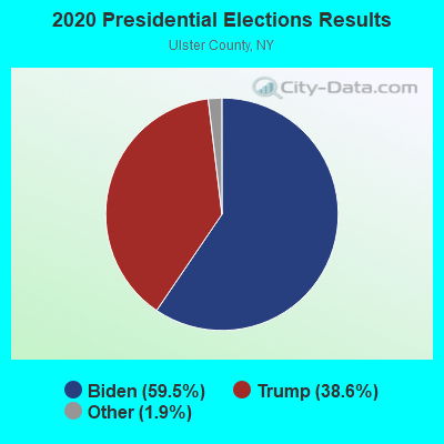
Graphs represent county-level data. Detailed 2008 Election Results
Religion statistics for Wawarsing, NY (based on Ulster County data)
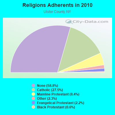
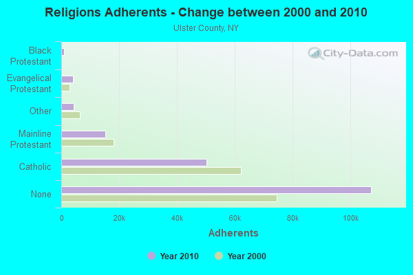
| Religion | Adherents | Congregations |
|---|---|---|
| Catholic | 50,256 | 27 |
| Mainline Protestant | 15,311 | 78 |
| Other | 4,262 | 30 |
| Evangelical Protestant | 4,104 | 42 |
| Black Protestant | 1,064 | 7 |
| Orthodox | 150 | 1 |
| None | 107,346 | - |
Food Environment Statistics:
| Ulster County: | 2.48 / 10,000 pop. |
| State: | 4.13 / 10,000 pop. |
| This county: | 0.11 / 10,000 pop. |
| State: | 0.06 / 10,000 pop. |
| Here: | 1.27 / 10,000 pop. |
| New York: | 0.92 / 10,000 pop. |
| Here: | 3.91 / 10,000 pop. |
| New York: | 1.68 / 10,000 pop. |
| This county: | 12.61 / 10,000 pop. |
| New York: | 8.82 / 10,000 pop. |
| This county: | 8.1% |
| State: | 8.2% |
| Ulster County: | 26.7% |
| State: | 23.8% |
| This county: | 18.9% |
| State: | 15.6% |
Strongest AM radio stations in Wawarsing:
- WELV (1370 AM; daytime; 5 kW; ELLENVILLE, NY; Owner: CLEAR CHANNEL BROADCASTING LICENSES, INC.)
- WGNY (1220 AM; 10 kW; NEWBURGH, NY; Owner: SUNRISE BROADCASTING LLC)
- WMCA (570 AM; 50 kW; NEW YORK, NY; Owner: SALEM MEDIA OF NEW YORK, LLC)
- WABC (770 AM; 50 kW; NEW YORK, NY; Owner: WABC-AM RADIO, INC.)
- WFAN (660 AM; 50 kW; NEW YORK, NY; Owner: INFINITY BROADCASTING OPERATIONS, INC.)
- WOR (710 AM; 50 kW; NEW YORK, NY; Owner: BUCKLEY BROADCASTING CORPORATION)
- WCBS (880 AM; 50 kW; NEW YORK, NY; Owner: INFINITY BROADCASTING OPERATIONS, INC.)
- WINS (1010 AM; 50 kW; NEW YORK, NY; Owner: INFINITY BROADCASTING OPERATIONS, INC.)
- WEPN (1050 AM; 50 kW; NEW YORK, NY; Owner: NEW YORK AM RADIO, LLC)
- WGY (810 AM; 50 kW; SCHENECTADY, NY; Owner: CLEAR CHANNEL BROADCASTING LICENSES, INC.)
- WSNR (620 AM; 20 kW; JERSEY CITY, NJ)
- WBBR (1130 AM; 50 kW; NEW YORK, NY; Owner: BLOOMBERG COMMUNICATIONS INC.)
- WADO (1280 AM; 50 kW; NEW YORK, NY; Owner: WADO-AM LICENSE CORP.)
Strongest FM radio stations in Wawarsing:
- WFKP (99.3 FM; ELLENVILLE, NY; Owner: CLEAR CHANNEL BROADCASTING LICENSES, INC.)
- WZAD (97.3 FM; WURTSBORO, NY; Owner: CUMULUS LICENSING CORP.)
- WPDH (101.5 FM; POUGHKEEPSIE, NY; Owner: CUMULUS LICENSING CORP.)
- WFNP (88.7 FM; ROSENDALE, NY; Owner: STATE UNIVERSITY OF NEW YORK)
- WRHV (88.7 FM; POUGHKEEPSIE, NY; Owner: WMHT EDUCATIONAL TELECOMMUNICATIONS)
- WOSR (91.7 FM; MIDDLETOWN, NY; Owner: WAMC)
- WAMK (90.9 FM; KINGSTON, NY; Owner: W A M C)
- WCZX (97.7 FM; HYDE PARK, NY; Owner: CUMULUS LICENSING CORP.)
- WFGB (89.7 FM; KINGSTON, NY; Owner: SOUND OF LIFE, INC.)
- WRRB (96.9 FM; ARLINGTON, NY; Owner: CUMULUS LICENSING CORP.)
- WBWZ (93.3 FM; NEW PALTZ, NY; Owner: CLEVELAND RADIO LICENSES, LLC)
- WRWD-FM (107.3 FM; HIGHLAND, NY; Owner: CLEVELAND RADIO LICENSES, LLC)
- WSPK (104.7 FM; POUGHKEEPSIE, NY; Owner: 6 JOHNSON ROAD LICENSES, INC.)
- WSUL (98.3 FM; MONTICELLO, NY; Owner: REYNOLDS COMMUNICATIONS, INC.)
- W292CM (106.3 FM; POUGHKEEPSIE, NY; Owner: JOHN KATONAH)
- WPDA (106.1 FM; JEFFERSONVILLE, NY; Owner: CUMULUS LICENSING CORP.)
- WLJP (89.3 FM; MONROE, NY; Owner: SOUND OF LIFE, INC.)
- WJFF (90.5 FM; JEFFERSONVILLE, NY; Owner: RADIO CATSKILL)
- WRNQ (92.1 FM; POUGHKEEPSIE, NY; Owner: CLEAR CHANNEL BROADCASTING LICENSES, INC.)
- WGWR (88.1 FM; LIBERTY, NY; Owner: SOUND OF LIFE, INC.)
TV broadcast stations around Wawarsing:
- WTBY (Channel 54; POUGHKEEPSIE, NY; Owner: TRINITY BROADCASTING OF NEW YORK, INC.)
- W30AZ (Channel 30; LIBERTY, NY; Owner: JOHN MESTER INCOME FAMILY TRUST)
- National Bridge Inventory (NBI) Statistics
- 33Number of bridges
- 377ft / 115mTotal length
- $101,576,000Total costs
- 70,421Total average daily traffic
- 5,065Total average daily truck traffic
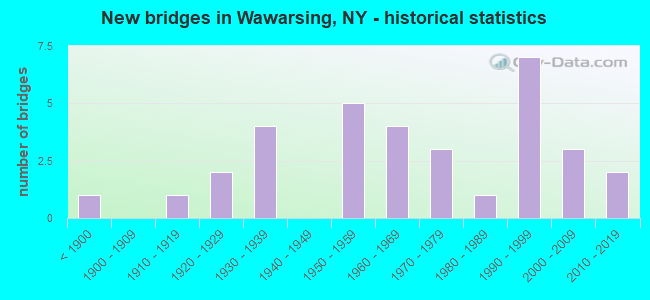
- New bridges - historical statistics
- 1Before 1900
- 11910-1919
- 21920-1929
- 41930-1939
- 51950-1959
- 41960-1969
- 31970-1979
- 11980-1989
- 71990-1999
- 32000-2009
- 22010-2019
FCC Registered Antenna Towers:
33 (See the full list of FCC Registered Antenna Towers in Wawarsing)FCC Registered Broadcast Land Mobile Towers:
1- Ulster Cell Site 23, Devilwood Road (Lat: 41.765833 Lon: -74.380000), Type: Tower, Structure height: 18.3 m, Call Sign: WQHN368,
Assigned Frequencies: 855.462 MHz, 855.712 MHz, 855.737 MHz, 856.212 MHz, 856.262 MHz, 856.437 MHz, 856.737 MHz, 856.937 MHz, 856.987 MHz, 857.212 MHz... (+10 more), Grant Date: 09/17/2007, Expiration Date: 09/17/2017, Cancellation Date: 01/14/2011, Certifier: Thomas J Cowper, Registrant: Nys Dhses Office Of Interoperable And Emergency Communications, State Office Campus Building 22, 1220 Washington Ave, Albany, NY 12226, Phone: (518) 322-4912, Fax: (518) 322-4975, Email:
FCC Registered Microwave Towers:
3- ELLENVILLE SOUTH, 8418 Route 209 (Lat: 41.705583 Lon: -74.416250), Type: Ltower, Structure height: 54.9 m, Call Sign: WQRU450,
Assigned Frequencies: 10815.0 MHz, Grant Date: 07/29/2013, Expiration Date: 07/29/2023, Cancellation Date: 01/05/2015, Certifier: John E Monday, Registrant: At&t Mobility LLC, 2200 N. Greenville Ave #1w, Richardson, TX 75082, Phone: (972) 234-7003, Fax: (972) 301-6893, Email:
- ELLENVILLE S, 8418 Rte. 209 (Ellenville Downtown) (Lat: 41.705583 Lon: -74.416250), Type: Mast, Structure height: 54.9 m, Call Sign: WQVK556,
Assigned Frequencies: 10815.0 MHz, Grant Date: 03/11/2015, Expiration Date: 03/11/2025, Cancellation Date: 06/23/2016, Certifier: John E Monday, Registrant: At&t Mobility LLC, 3300 E Renner Road, B3132, Richardson, TX 75082, Phone: (855) 699-7073, Fax: (972) 907-1131, Email:
- WAWARSING, Same Point Rd (Lat: 41.667306 Lon: -74.369306), Overall height: 68.6 m, Call Sign: WHO333, Licensee ID: L00129200,
Assigned Frequencies: 5945.20 MHz, 5974.85 MHz, 6034.15 MHz, 6004.50 MHz, 6093.45 MHz, 6063.80 MHz, 6123.10 MHz, 6152.75 MHz, Grant Date: 02/27/2001, Expiration Date: 02/01/2011, Cancellation Date: 09/07/2007, Certifier: Michael J Shortley Iii, Registrant: Global Crossing North American Networks, Inc.
FCC Registered Amateur Radio Licenses:
1- Call Sign: KB2KBT, Grant Date: 06/08/1994, Expiration Date: 05/08/2000, Cancellation Date: 05/09/2002, Registrant: George E Anderson, Bx 51 Kagan Ln, Wawarsing, NY 12489
| Most common first names in Wawarsing, NY among deceased individuals | ||
| Name | Count | Lived (average) |
|---|---|---|
| William | 9 | 75.2 years |
| John | 6 | 74.3 years |
| Thomas | 5 | 61.0 years |
| George | 5 | 74.8 years |
| James | 3 | 71.3 years |
| Abraham | 3 | 72.7 years |
| Louise | 3 | 75.0 years |
| Michael | 3 | 72.6 years |
| Morris | 3 | 76.3 years |
| Alice | 3 | 70.7 years |
| Most common last names in Wawarsing, NY among deceased individuals | ||
| Last name | Count | Lived (average) |
|---|---|---|
| Smith | 7 | 75.6 years |
| Terwilliger | 4 | 83.2 years |
| Eck | 3 | 69.0 years |
| Lee | 3 | 75.7 years |
| Schoonmaker | 3 | 62.3 years |
| Atkins | 3 | 79.3 years |
| Churchwell | 3 | 83.3 years |
| Ryan | 3 | 63.7 years |
| Kortright | 3 | 88.0 years |
| Phillips | 3 | 89.0 years |
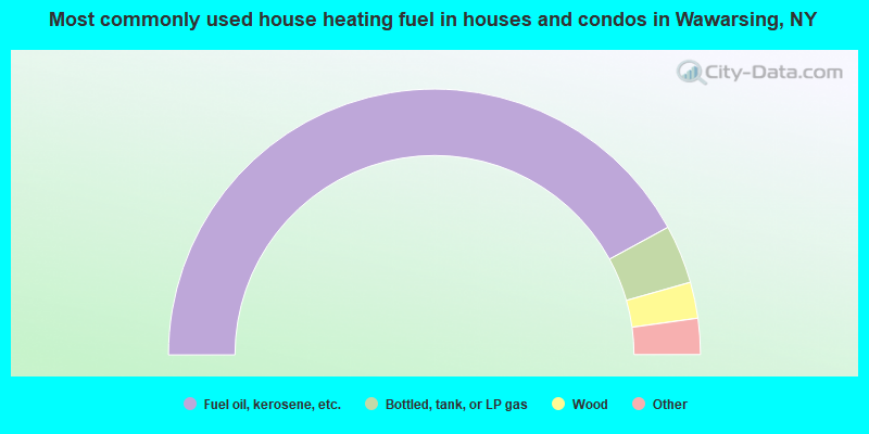
- 84.1%Fuel oil, kerosene, etc.
- 7.1%Bottled, tank, or LP gas
- 4.4%Wood
- 3.1%Electricity
- 1.2%Utility gas
- 0.1%Coal or coke
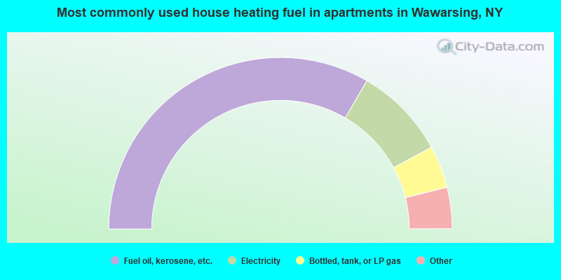
- 66.8%Fuel oil, kerosene, etc.
- 17.4%Electricity
- 8.0%Bottled, tank, or LP gas
- 3.3%Utility gas
- 2.2%Wood
- 1.6%Other fuel
- 0.4%No fuel used
- 0.2%Coal or coke
Wawarsing compared to New York state average:
- Median house value below state average.
- Unemployed percentage below state average.
- Foreign-born population percentage significantly below state average.
- Length of stay since moving in significantly above state average.
- Number of rooms per house significantly below state average.
- House age significantly below state average.
- Institutionalized population percentage significantly above state average.
- Percentage of population with a bachelor's degree or higher below state average.
Wawarsing on our top lists:
- #2 on the list of "Top 101 cities with largest percentage of females in industries: metal and metal products (population 5,000+)"
- #11 on the list of "Top 101 cities with largest percentage of males in occupations: cashiers (population 5,000+)"
- #12 on the list of "Top 101 cities with largest percentage of males in industries: metal and metal products (population 5,000+)"
- #14 on the list of "Top 101 cities with largest percentage of males in occupations: other food preparation and serving workers including supervisors (population 5,000+)"
- #16 on the list of "Top 101 cities with the largest percentage of people in homes or halfway houses for drug/alcohol abuse (population 1,000+)"
- #20 on the list of "Top 101 cities with largest percentage of males in industries: groceries and related products merchant wholesalers (population 5,000+)"
- #26 on the list of "Top 101 cities with largest percentage of males in occupations: waiters and waitresses (population 5,000+)"
- #26 on the list of "Top 101 cities with largest percentage of females in industries: apparel (population 5,000+)"
- #31 on the list of "Top 101 cities with largest percentage of females in industries: vending machine operators (population 5,000+)"
- #49 on the list of "Top 101 cities with largest percentage of males in industries: fuel dealers (population 5,000+)"
- #60 on the list of "Top 101 cities with largest percentage of females in occupations: textile, apparel, and furnishings workers (population 5,000+)"
- #76 on the list of "Top 101 cities with largest percentage of males in industries: food and beverage stores (population 5,000+)"
- #90 on the list of "Top 101 cities with largest percentage of males in occupations: special education teachers (population 5,000+)"
- #92 on the list of "Top 101 cities with largest percentage of females in occupations: bus drivers (population 5,000+)"
- #7 on the list of "Top 101 counties with the highest surface withdrawal of fresh water for public supply"
- #9 on the list of "Top 101 counties with the highest total withdrawal of fresh water for public supply"
- #13 on the list of "Top 101 counties with the lowest percentage of residents relocating from foreign countries between 2010 and 2011"
- #18 on the list of "Top 101 counties with the lowest number of births per 1000 residents 2007-2013"
- #44 on the list of "Top 101 counties with the lowest Sulfur Oxides Annual air pollution readings in 2012 (µg/m3)"