Wayan, Idaho
Submit your own pictures of this place and show them to the world
- OSM Map
- General Map
- Google Map
- MSN Map

| Males: 138 | |
| Females: 128 |
| Median resident age: | 36.0 years |
| Idaho median age: | 33.2 years |
| Wayan: | $46,742 |
| ID: | $72,785 |
Estimated per capita income in 2022: $25,072 (it was $12,386 in 2000)
Wayan CCD income, earnings, and wages data
Estimated median house or condo value in 2022: $450,418 (it was $130,600 in 2000)
| Wayan: | $450,418 |
| ID: | $432,500 |
Mean prices in 2022: all housing units: $289,993; detached houses: $298,910; townhouses or other attached units: $207,668; mobile homes: $199,813
Detailed information about poverty and poor residents in Wayan, ID


- 26593.3%White alone
- 196.7%Hispanic

Races in Wayan detailed stats: ancestries, foreign born residents, place of birth
 Recent articles from our blog. Our writers, many of them Ph.D. graduates or candidates, create easy-to-read articles on a wide variety of topics.

Current Local Time: MST time zone
Elevation: 6437 feet
Land area: 720.9 square miles.
Population density: 0.4 people per square mile (very low).

| Wayan CCD: | 0.8% ($1,056) |
| Idaho: | 1.0% ($1,007) |
Nearest city with pop. 50,000+: Pocatello, ID  (56.7 miles , pop. 51,466).
Nearest city with pop. 200,000+: West Adams, CO (387.2 miles , pop. 259,628).
Nearest city with pop. 1,000,000+: Phoenix, AZ (644.6 miles , pop. 1,321,045).
Nearest cities:
), ), Latitude: 42.83 N, Longitude: 111.33 W
Area code: 208


| Here: | 2.6% |
| Idaho: | 3.1% |
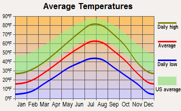
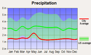
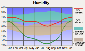
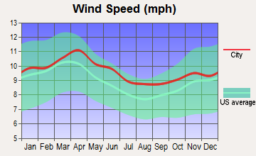
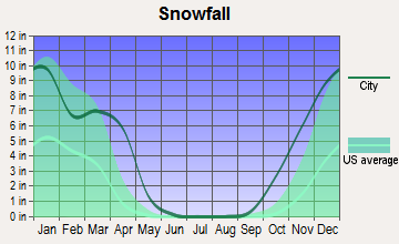
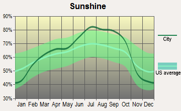
Average climate in Wayan, Idaho
Based on data reported by over 4,000 weather stations
(lower is better)

Air Quality Index (AQI) level in 2001 was 21.2. This is significantly better than average.
| City: | 21.2 |
| U.S.: | 72.6 |

Sulfur Dioxide (SO2) [ppb] level in 2001 was 2.74. This is significantly worse than average. Closest monitor was 12.3 miles away from the city center.
| City: | 2.74 |
| U.S.: | 1.51 |
Earthquake activity:
Wayan-area historical earthquake activity is significantly above Idaho state average. It is 1727% greater than the overall U.S. average.On 8/18/1959 at 06:37:13, a magnitude 7.7 (7.7 UK, Class: Major, Intensity: VIII - XII) earthquake occurred 124.8 miles away from the city center, causing $26,000,000 total damage
On 10/28/1983 at 14:06:06, a magnitude 7.3 (6.2 MB, 7.3 MS, 7.0 MW) earthquake occurred 151.1 miles away from Wayan center, causing 2 deaths (2 shaking deaths) and 3 injuries, causing $15,000,000 total damage
On 10/3/1915 at 06:52:48, a magnitude 7.6 (7.6 UK) earthquake occurred 357.0 miles away from Wayan center
On 3/28/1975 at 02:31:05, a magnitude 6.2 (6.1 MB, 6.0 MS, 6.2 ML, Class: Strong, Intensity: VII - IX) earthquake occurred 81.3 miles away from Wayan center
On 2/3/1994 at 09:05:04, a magnitude 5.8 (5.4 MB, 5.5 MS, 5.8 MW, 5.8 ML, Depth: 4.9 mi, Class: Moderate, Intensity: VI - VII) earthquake occurred 18.9 miles away from the city center
On 6/30/1975 at 18:54:13, a magnitude 6.1 (5.6 MB, 5.9 MS, 6.1 UK, 6.1 ML) earthquake occurred 131.0 miles away from the city center
Magnitude types: body-wave magnitude (MB), local magnitude (ML), surface-wave magnitude (MS), moment magnitude (MW)
Natural disasters:
The number of natural disasters in Caribou County (4) is a lot smaller than the US average (15).Major Disasters (Presidential) Declared: 1
Emergencies Declared: 2
Causes of natural disasters: Drought: 1, Flood: 1, Heavy Rain: 1, Hurricane: 1, Other: 1 (Note: some incidents may be assigned to more than one category).
Colleges/universities with over 2000 students nearest to Wayan:
- Idaho State University (about 56 miles; Pocatello, ID; Full-time enrollment: 10,350)
- Brigham Young University-Idaho (about 72 miles; Rexburg, ID; FT enrollment: 30,522)
- Utah State University (about 80 miles; Logan, UT; FT enrollment: 21,131)
- Weber State University (about 118 miles; Ogden, UT; FT enrollment: 17,655)
- Western Wyoming Community College (about 138 miles; Rock Springs, WY; FT enrollment: 2,086)
- Latter-day Saints Business College (about 146 miles; Salt Lake City, UT; FT enrollment: 2,059)
- University of Utah (about 146 miles; Salt Lake City, UT; FT enrollment: 28,454)
Points of interest:
Notable locations in Wayan: Dry Valley Guard Station (A), Johnson Guard Station (B), Nate Ranch (C), Young Ranch (D), Petersons Ranch (E), Maybey Canyon Phosphate Mining Area (F), Mill Canyon Campground (G), Pine Bar Campground (H), Miller Ranch (I), Blackfoot River Park Access Area (J), Smith Sawmill (K), Stocking Ranch (L), Stewart Ranch (M), Stump Creek Guard Station (N), Clear Creek Guard Station (O), Summit View Campground (P), Sweet Ranch (Q), Middle Dairy (R), Gravel Creek Campground (S), Tincup Campground (T). Display/hide their locations on the map
Cemeteries: Freedom Cemetery (1), Lanes Grave Cemetery (2). Display/hide their locations on the map
Lakes, reservoirs, and swamps: The Narrows (A), Grays Lake (B), Goose Lake (C). Display/hide their locations on the map
Streams, rivers, and creeks: Chippy Creek (A), Cabin Creek (B), Meadow Creek (C), Brush Creek (D), Books Creek (E), North Fork Stump Creek (F), Pine Creek (G), Noon Creek (H), Bacon Creek (I). Display/hide their locations on the map
Parks in Wayan include: Henry Stampede Park (1), Blackfoot River Park (2). Display/hide their locations on the map
| This place: | 2.8 people |
| Idaho: | 2.7 people |
| This place: | 81.4% |
| Whole state: | 69.6% |
| This place: | 2.3% |
| Whole state: | 6.3% |
No gay or lesbian households reported
| This place: | 19.5% |
| Whole state: | 11.8% |
| This place: | 4.8% |
| Whole state: | 4.6% |
For population 15 years and over in Wayan:

- Never married: 17.7%
- Now married: 74.4%
- Separated: 0.0%
- Widowed: 4.9%
- Divorced: 3.0%
For population 25 years and over in Wayan:
- High school or higher: 94.3%
- Bachelor's degree or higher: 20.7%
- Graduate or professional degree: 0.0%
- Mean travel time to work (commute): 15.0 minutes


| Here: | 6.6 |
| Idaho average: | 11.1 |
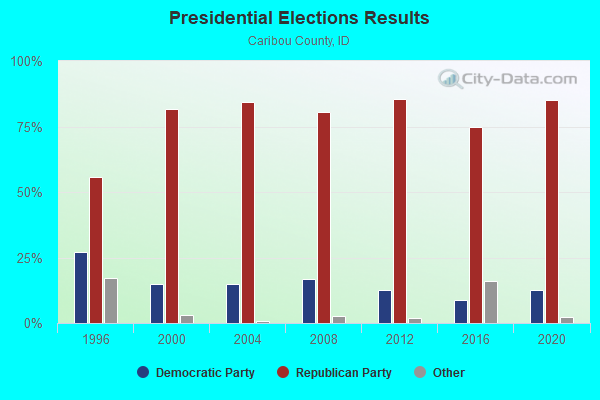
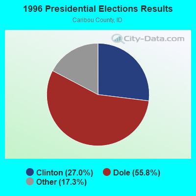
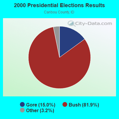
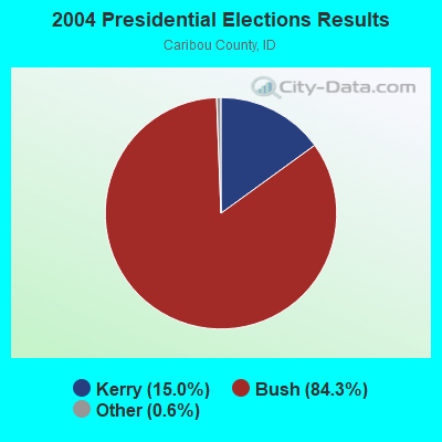
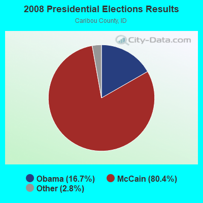
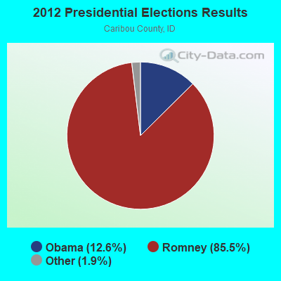
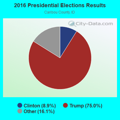
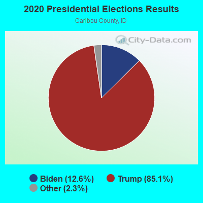
Graphs represent county-level data. Detailed 2008 Election Results
Religion statistics for Wayan, ID (based on Caribou County data)
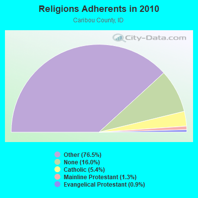
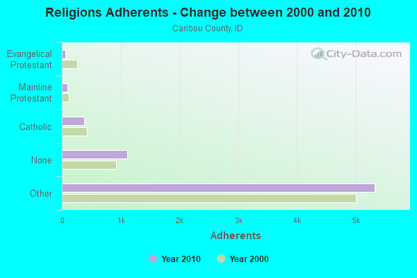
| Religion | Adherents | Congregations |
|---|---|---|
| Other | 5,327 | 15 |
| Catholic | 374 | 2 |
| Mainline Protestant | 90 | 1 |
| Evangelical Protestant | 60 | 3 |
| None | 1,112 | - |
Food Environment Statistics:
| Here: | 4.39 / 10,000 pop. |
| Idaho: | 1.88 / 10,000 pop. |
| Caribou County: | 5.85 / 10,000 pop. |
| Idaho: | 3.87 / 10,000 pop. |
| Caribou County: | 4.39 / 10,000 pop. |
| State: | 7.75 / 10,000 pop. |
| Caribou County: | 8.8% |
| Idaho: | 7.7% |
| Caribou County: | 25.3% |
| State: | 25.7% |
| Here: | 7.0% |
| State: | 11.7% |
Strongest AM radio stations in Wayan:
- KBRV (790 AM; 5 kW; SODA SPRINGS, ID; Owner: CARIBOU BROADCASTING INC.)
- KRSV (1210 AM; 5 kW; AFTON, WY; Owner: WESTERN WYOMING RADIO, INC.)
- KZNR (690 AM; 10 kW; BLACKFOOT, ID; Owner: WESTERN COMMUNICATIONS, INC.)
- KALL (700 AM; 50 kW; NORTH SALT LAKE CITY, UT; Owner: CITICASTERS LICENSES, L.P.)
- KID (590 AM; 5 kW; IDAHO FALLS, ID; Owner: CITICASTERS LICENSES, L.P.)
- KIQN (1010 AM; 50 kW; TOOELE, UT)
- KSL (1160 AM; 50 kW; SALT LAKE CITY, UT; Owner: BONNEVILLE HOLDING COMPANY)
- KBLI (1620 AM; 10 kW; BLACKFOOT, ID; Owner: WESTERN COMMUNICATIONS, INC.)
- KSEI (930 AM; 5 kW; POCATELLO, ID; Owner: PACIFIC EMPIRE COMMUNICATIONS CORP.)
- KUPI (980 AM; 5 kW; AMMON, ID; Owner: RAY GROTH OIL COMPANY, INC.)
- KSOS (800 AM; 10 kW; BRIGHAM CITY, UT; Owner: SIMMONS-SLC, LS, LLC)
- KZNI (1260 AM; 5 kW; IDAHO FALLS, ID)
- KBOI (670 AM; 50 kW; BOISE, ID; Owner: CITADEL BROADCASTING COMPANY)
Strongest FM radio stations in Wayan:
- K275AB (102.9 FM; FREEDOM, WY; Owner: LOWER STAR VALLEY TV ASSOCIATION)
- KCHQ (102.1 FM; DRIGGS, ID; Owner: TED W. AUSTIN, JR.)
- K299AH (107.7 FM; POCATELLO, ID; Owner: UNIVERSITY OF UTAH)
- K209BO (89.7 FM; TETONIA, ID; Owner: FAITH COMMUNICATIONS CORPORATION)
- KBJX (107.9 FM; SHELLEY, ID; Owner: PACIFIC EMPIRE COMMUNICATIONS CORP)
- KLLP (98.5 FM; CHUBBUCK, ID; Owner: CITICASTERS LICENSES, L.P.)
- K260AD (99.9 FM; MONTPELIER, ID; Owner: BEAR LAKE COUNTY T.V. DISTRICT)
- K264AD (100.7 FM; MONTPELIER, ID; Owner: BEAR LAKE COUNTY T.V. DISTRICT)
- K276DR (103.1 FM; MONTPELIER, ID; Owner: BEAR LAKE COUNTY T.V. DISTRICT)
- K287AB (105.3 FM; MONTPELIER, ID; Owner: BEAR LAKE COUNTY T.V. DISTRICT)
TV broadcast stations around Wayan:
- K59BV (Channel 59; LAVA HOT SPRINGS, ID; Owner: STATE BOARD OF EDUCATION (IEPBS))
FCC Registered Cell Phone Towers:
1- (Star Valley) Black Mountain Communication (Lat: 43.105222 Lon: -111.123000), Type: Ltower, Structure height: 42.7 m, Overall height: 46 m, Call Sign: KNKN306
Assigned Frequencies: 869.040 MHz, 824.040 MHz, 890.010 MHz, 845.010 MHzGrant Date: 09/01/2020, Expiration Date: 10/01/2030, Certifier: Gregory M RomanoRegistrant: Verizon Wireless, 5055 North Point Pkwy, Np2ne Network Engineering, Alpharetta, GA 30022, Phone: (770) 797-1070, Fax: (202) 783-5851, Email:
FCC Registered Broadcast Land Mobile Towers:
2- Caribou Mountain 10 Mi Nne (Lat: 43.085472 Lon: -111.305778), Type: Tower, Structure height: 15 m, Call Sign: WNMB434,
Assigned Frequencies: 159.330 MHz, 159.390 MHz, Grant Date: 04/18/2023, Expiration Date: 07/05/2033, Registrant: State Of Idaho, Military Division, 700 South Stratford Drive, Building 6, Boise, ID 83720-0076, Phone: (208) 288-4000, Fax: (208) 288-2605, Email:
- Uprr Wooley Valley 12 Mi N (Lat: 42.798528 Lon: -111.394944), Type: Pole, Structure height: 23 m, Overall height: 24 m, Call Sign: WNKY883, Licensee ID: L00258361,
Assigned Frequencies: 935.887 MHz, 935.937 MHz, 935.987 MHz, 936.887 MHz, 936.937 MHz, 936.987 MHz, Grant Date: 02/11/1998, Expiration Date: 02/11/2003, Cancellation Date: 04/12/2001, Certifier: Robert Vandeberg, Registrant: Association Of American Railroad Dba Transportation Technology Ctr Inc Uprr, 55500 Dot Rd, Pueblo, CO 81001, Phone: (719) 584-0578, Fax: (719) 584-7145
FCC Registered Microwave Towers:
2- BLACK MTN, 6.6 Miles Wsw Of Alpine, Wyoming (Lat: 43.105028 Lon: -111.122667), Type: Ltower, Structure height: 24.3 m, Call Sign: WQVM575,
Assigned Frequencies: 6605.00 MHz, Grant Date: 03/30/2015, Expiration Date: 03/30/2025, Certifier: Charles E Kakalecik, Registrant: State Of Wyoming, 5300 Bishop Blvd., Cheyenne, WY 82009, Phone: (307) 777-4440, Fax: (307) 777-4764, Email:
- SOMSEN, 5241 Highway 34 (Lat: 42.976556 Lon: -111.364528), Type: Ltower, Structure height: 29 m, Overall height: 30.5 m, Call Sign: WRCM568,
Assigned Frequencies: 10755.0 MHz, 10755.0 MHz, 10755.0 MHz, 10755.0 MHz, 10755.0 MHz, 10755.0 MHz, 10755.0 MHz, 10755.0 MHz, Grant Date: 11/09/2018, Expiration Date: 11/09/2028, Certifier: Allen R Hoopes, Registrant: Womble Bond Dickinson (Us) LLP, 1200 19th Street, Nw, Suite 500, Washington, DC 20036, Phone: (202) 857-4519, Email:
FCC Registered Paging Towers:
1- Off Highway 34, 1/2 Mile Northeast Of (Lat: 42.976306 Lon: -111.364639), Call Sign: KNKM718,
Assigned Frequencies: 454.525 MHz, 454.475 MHz, 454.425 MHz, 454.375 MHz, Grant Date: 12/27/2018, Expiration Date: 11/01/2028, Registrant: Womble Bond Dickinson (Us) LLP, 1200 19th Street, Nw, Suite 500, Washington, DC 20036, Phone: (202) 857-4519, Email:

- 68.0%Bottled, tank, or LP gas
- 18.0%Fuel oil, kerosene, etc.
- 14.0%Electricity

- 57.1%Coal or coke
- 42.9%Electricity
Wayan compared to Idaho state average:
- Median household income below state average.
- Unemployed percentage significantly below state average.
- Black race population percentage significantly below state average.
- Hispanic race population percentage below state average.
- Median age below state average.
- Foreign-born population percentage significantly below state average.
- Length of stay since moving in significantly above state average.
- Number of rooms per house significantly below state average.
- House age significantly below state average.
- Number of college students significantly below state average.