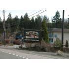
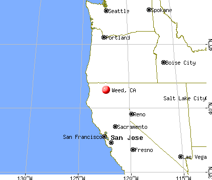
Weed, California
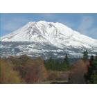
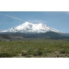
Weed: View of Mt. Shasta from Weed, CA
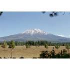
Weed: Mt. Shasta from Weed, CA
Weed: view of mt. shasta from weed
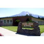
Weed: Weed High School

Weed: Bart Simpson Loves Weed
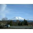
Weed: Mt. Shasta
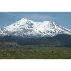
Weed: Mt. Shasta
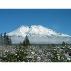
Weed: Mt. Shasta in Winter
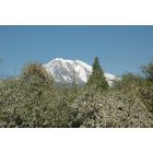
Weed: View of Mt. Shasta from my yard
Weed: weed welcome sign
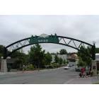
Weed: Weed Arch over Main Street
- see
14
more - add
your


Submit your own pictures of this city and show them to the world
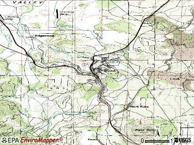
- OSM Map
- General Map
- Google Map
- MSN Map

Population change since 2000: -5.6%
 |
| Males: 1,451 | |
| Females: 1,360 |
| Median resident age: | 44.8 years |
| California median age: | 37.9 years |
Zip codes: 96094.
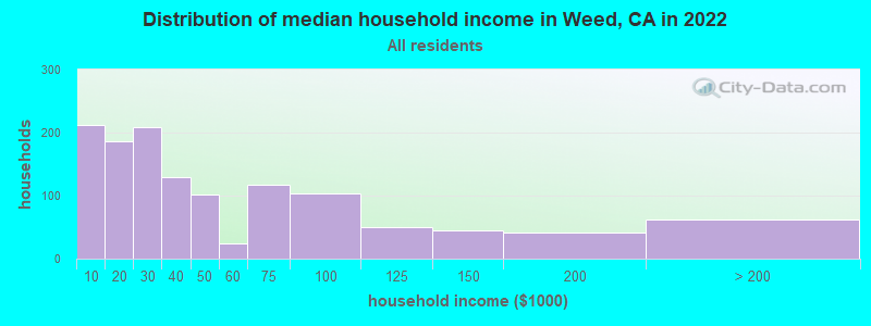
| Weed: | $35,504 |
| CA: | $91,551 |
Estimated per capita income in 2022: $49,473 (it was $12,434 in 2000)
Weed city income, earnings, and wages data
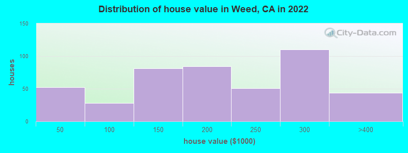
Estimated median house or condo value in 2022: $215,867 (it was $71,500 in 2000)
| Weed: | $215,867 |
| CA: | $715,900 |
Mean prices in 2022: all housing units: $211,419; detached houses: $227,044; mobile homes: $8,901
Median gross rent in 2022: $749.
(36.4% for White Non-Hispanic residents, 37.6% for Black residents, 27.3% for Hispanic or Latino residents, 79.4% for American Indian residents, 19.4% for other race residents, 21.5% for two or more races residents)
Detailed information about poverty and poor residents in Weed, CA
Compare current foreclosures near Weed, CA:
| Photo | Address | Area | Beds / Baths | Price | Details |
|---|---|---|---|---|---|

|
#1
Carrick Ave
Weed, CA 96094
|
1,617 sq. feet
|
2 baths 4 beds |
$155,000
|
show details |

|
#2
1st St
Weed, CA 96094
|
874 sq. feet
|
1 baths 2 beds |
show details | |

|
#3
Pine St
Weed, CA 96094
|
- sq. feet
|
- baths - beds |
$1,600
|
show details |

|
#4
Windmill Dr
Weed, CA 96094
|
2,660 sq. feet
|
2 baths 4 beds |
show details | |

|
#5
Windmill Dr
Weed, CA 96094
|
2,660 sq. feet
|
2 baths 4 beds |
show details | |

|
#6
Cottontail Dr
Weed, CA 96094
|
1,512 sq. feet
|
2 baths 3 beds |
show details | |

|
#7
Stringtown Ave
Weed, CA 96094
|
- sq. feet
|
- baths - beds |
show details | |

|
#8
A-12
Grenada, CA 96038
|
1,814 sq. feet
|
2 baths 3 beds |
$199,000
|
show details |

|
#9
88 Hogan
Weed, CA 96094
|
- sq. feet
|
- baths - beds |
show details | |

|
#10
N Old Stage Rd
Weed, CA 96094
|
- sq. feet
|
- baths - beds |
show details |
| Photo | Address | Area | Beds / Baths | Price | Details |
|---|---|---|---|---|---|

|
#11
College Ave
Weed, CA 96094
|
- sq. feet
|
- baths - beds |
show details | |

|
#12
273 Sherwood
Weed, CA 96094
|
- sq. feet
|
- baths - beds |
show details | |

|
#13
116 Buffalo
Weed, CA 96094
|
- sq. feet
|
- baths - beds |
show details | |

|
#14
131 Fisher
Weed, CA 96094
|
- sq. feet
|
- baths - beds |
show details | |

|
#15
Angel Valley Rd
Weed, CA 96094
|
- sq. feet
|
- baths - beds |
show details | |

|
#16
40 Hwy 97
Weed, CA 96094
|
- sq. feet
|
- baths - beds |
show details | |

|
#17
30 Hwy 97
Weed, CA 96094
|
- sq. feet
|
- baths - beds |
show details | |

|
#18
32 Silver Spur Rd
Weed, CA 96094
|
- sq. feet
|
- baths - beds |
show details | |

|
#19
30 Silver Spur Rd
Weed, CA 96094
|
- sq. feet
|
- baths - beds |
show details | |

|
#20
2nd Ave
Weed, CA 96094
|
- sq. feet
|
- baths - beds |
show details |
| Photo | Address | Area | Beds / Baths | Price | Details |
|---|---|---|---|---|---|

|
#21
187 Sherwood
Weed, CA 96094
|
- sq. feet
|
- baths - beds |
show details | |

|
#22
Siskiyou Ave
Dunsmuir, CA 96025
|
1,412 sq. feet
|
2 baths 3 beds |
show details | |

|
#23
S A St
Mount Shasta, CA 96067
|
912 sq. feet
|
1 baths 2 beds |
show details | |

|
#24
Sacramento Ave
Dunsmuir, CA 96025
|
- sq. feet
|
- baths - beds |
$20,000
|
show details |

|
#25
5816 Dunsmuir Ave
Dunsmuir, CA 96025
|
- sq. feet
|
- baths - beds |
$25,000
|
show details |

|
#26
Dolomite Ave
Montague, CA 96064
|
- sq. feet
|
- baths - beds |
$15,000
|
show details |

|
#27
Siskiyou Ave
Dunsmuir, CA 96025
|
- sq. feet
|
- baths - beds |
$15,000
|
show details |

|
#28
Cayuse Meadows Rd
Mount Shasta, CA 96067
|
- sq. feet
|
- baths - beds |
$15,000
|
show details |

|
#29
Wells Ave
Dunsmuir, CA 96025
|
- sq. feet
|
- baths - beds |
$30,000
|
show details |

|
#30
E Louie Rd
Montague, CA 96064
|
- sq. feet
|
- baths - beds |
$20,000
|
show details |
| Photo | Address | Area | Beds / Baths | Price | Details |
|---|---|---|---|---|---|

|
#31
Michele Dr
Mount Shasta, CA 96067
|
3,084 sq. feet
|
3 baths 4 beds |
show details | |

|
#32
Cedar View Ln
Mount Shasta, CA 96067
|
- sq. feet
|
- baths - beds |
$16,000
|
show details |

|
#33
Dunsmuir Ave
Dunsmuir, CA 96025
|
- sq. feet
|
- baths - beds |
$20,000
|
show details |

|
#34
Gleaves Ave
Dunsmuir, CA 96025
|
- sq. feet
|
- baths - beds |
show details | |

|
#35
Alpine St
Dunsmuir, CA 96025
|
- sq. feet
|
- baths - beds |
show details | |

|
#36
Quartz Ave
Montague, CA 96064
|
- sq. feet
|
- baths - beds |
show details | |

|
#37
Orem St
Mount Shasta, CA 96067
|
- sq. feet
|
- baths - beds |
show details | |

|
#38
Castle Ave
Dunsmuir, CA 96025
|
- sq. feet
|
- baths - beds |
show details | |

|
Check over 1 million property listings on Foreclosure.com!
|
browse all offers | |||


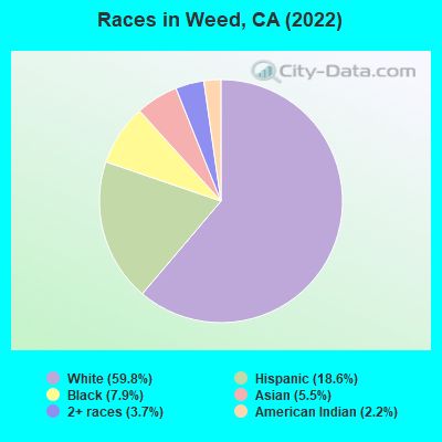
- 1,68659.8%White alone
- 52618.6%Hispanic
- 2237.9%Black alone
- 1545.5%Asian alone
- 1053.7%Two or more races
- 612.2%American Indian alone
According to our research of California and other state lists, there were 16 registered sex offenders living in Weed, California as of April 24, 2024.
The ratio of all residents to sex offenders in Weed is 175 to 1.
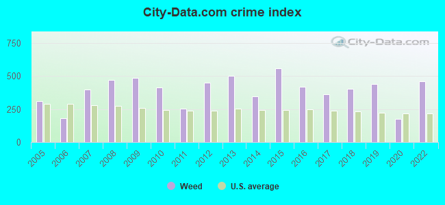
Type |
2009 |
2010 |
2011 |
2012 |
2013 |
2014 |
2015 |
2016 |
2017 |
2018 |
2019 |
2020 |
2022 |
|---|---|---|---|---|---|---|---|---|---|---|---|---|---|
| Murders (per 100,000) | 0 (0.0) | 0 (0.0) | 0 (0.0) | 1 (33.7) | 0 (0.0) | 0 (0.0) | 1 (35.3) | 0 (0.0) | 0 (0.0) | 0 (0.0) | 0 (0.0) | 0 (0.0) | 0 (0.0) |
| Rapes (per 100,000) | 2 (66.0) | 4 (134.8) | 0 (0.0) | 1 (33.7) | 6 (205.0) | 3 (103.7) | 3 (105.8) | 1 (40.3) | 0 (0.0) | 2 (74.6) | 3 (112.2) | 0 (0.0) | 7 (242.4) |
| Robberies (per 100,000) | 4 (132.0) | 3 (101.1) | 1 (33.3) | 5 (168.4) | 3 (102.5) | 2 (69.1) | 4 (141.0) | 5 (201.7) | 0 (0.0) | 4 (149.1) | 4 (149.6) | 0 (0.0) | 3 (103.9) |
| Assaults (per 100,000) | 23 (758.8) | 14 (471.9) | 13 (433.0) | 11 (370.4) | 17 (580.8) | 15 (518.3) | 23 (811.0) | 17 (685.8) | 23 (882.9) | 20 (745.7) | 27 (1,010) | 9 (333.5) | 19 (657.9) |
| Burglaries (per 100,000) | 46 (1,518) | 32 (1,079) | 30 (999.3) | 38 (1,279) | 33 (1,127) | 13 (449.2) | 23 (811.0) | 13 (524.4) | 23 (882.9) | 13 (484.7) | 8 (299.3) | 11 (407.6) | 17 (588.6) |
| Thefts (per 100,000) | 77 (2,540) | 57 (1,921) | 52 (1,732) | 68 (2,290) | 74 (2,528) | 63 (2,177) | 83 (2,927) | 78 (3,146) | 62 (2,380) | 62 (2,312) | 38 (1,422) | 34 (1,260) | 34 (1,177) |
| Auto thefts (per 100,000) | 12 (395.9) | 10 (337.0) | 6 (199.9) | 19 (639.7) | 3 (102.5) | 8 (276.4) | 9 (317.3) | 8 (322.7) | 10 (383.9) | 7 (261.0) | 9 (336.7) | 10 (370.5) | 5 (173.1) |
| Arson (per 100,000) | 0 (0.0) | 0 (0.0) | 0 (0.0) | 0 (0.0) | 0 (0.0) | 0 (0.0) | 0 (0.0) | 0 (0.0) | 0 (0.0) | 0 (0.0) | 0 (0.0) | 0 (0.0) | 1 (34.6) |
| City-Data.com crime index | 483.7 | 411.9 | 251.8 | 451.2 | 499.1 | 348.0 | 558.9 | 418.3 | 364.3 | 400.8 | 441.5 | 175.3 | 458.8 |
The City-Data.com crime index weighs serious crimes and violent crimes more heavily. Higher means more crime, U.S. average is 246.1. It adjusts for the number of visitors and daily workers commuting into cities.
Crime rate in Weed detailed stats: murders, rapes, robberies, assaults, burglaries, thefts, arson
Full-time law enforcement employees in 2021, including police officers: 12 (6 officers - 6 male; 0 female).
| Officers per 1,000 residents here: | 2.27 |
| California average: | 2.30 |
 Recent articles from our blog. Our writers, many of them Ph.D. graduates or candidates, create easy-to-read articles on a wide variety of topics.


 | California RECALL Megathread! (1307 replies) |
| Redding California + Weed California (4 replies) |
| Do you love Weed? (27 replies) |
| Weed, CA Crime (5 replies) |
| Marijuana goes legal in California on Jan. 1. What you need to know (147 replies) |
| Weed, CA gets torched by wildfire (8 replies) |
Latest news from Weed, CA collected exclusively by city-data.com from local newspapers, TV, and radio stations
Ancestries: English (15.4%), Italian (6.2%), American (4.6%), European (4.5%), German (4.0%), Polish (2.5%).
Current Local Time: PST time zone
Elevation: 3466 feet
Land area: 4.85 square miles.
Population density: 579 people per square mile (low).
203 residents are foreign born (4.9% Latin America, 2.1% Asia).
| This city: | 7.2% |
| California: | 26.5% |
Median real estate property taxes paid for housing units with mortgages in 2022: $1,256 (0.6%)
Median real estate property taxes paid for housing units with no mortgage in 2022: $1,352 (0.6%)
Nearest city with pop. 50,000+: Redding, CA  (58.6 miles , pop. 80,865).
Nearest city with pop. 200,000+: Sacramento, CA (204.3 miles , pop. 407,018).
Nearest city with pop. 1,000,000+: Los Angeles, CA (552.7 miles , pop. 3,694,820).
Nearest cities:
Latitude: 41.42 N, Longitude: 122.38 W
Area code: 530
Weed tourist attractions:
Weed, California accommodation & food services, waste management - Economy and Business Data
Single-family new house construction building permits:
- 2022: 2 buildings, average cost: $250,000
- 2021: 5 buildings, average cost: $133,300
- 2020: 4 buildings, average cost: $133,300
- 2019: 2 buildings, average cost: $195,400
- 2018: 2 buildings, average cost: $195,400
- 2017: 4 buildings, average cost: $239,100
- 2016: 20 buildings, average cost: $242,400
- 2015: 44 buildings, average cost: $235,700
- 2003: 1 building, cost: $51,100
- 2002: 7 buildings, average cost: $93,500
- 2001: 1 building, cost: $63,300
- 1999: 1 building, cost: $65,300

| Here: | 7.3% |
| California: | 5.1% |
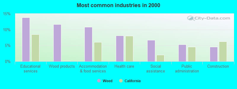
- Educational services (13.8%)
- Wood products (11.7%)
- Accommodation & food services (10.8%)
- Health care (8.1%)
- Social assistance (6.7%)
- Public administration (5.3%)
- Construction (4.5%)
- Wood products (21.2%)
- Educational services (10.5%)
- Construction (6.7%)
- Accommodation & food services (6.3%)
- Building material & garden equipment & supplies dealers (5.8%)
- Public administration (5.0%)
- Food & beverage stores (4.6%)
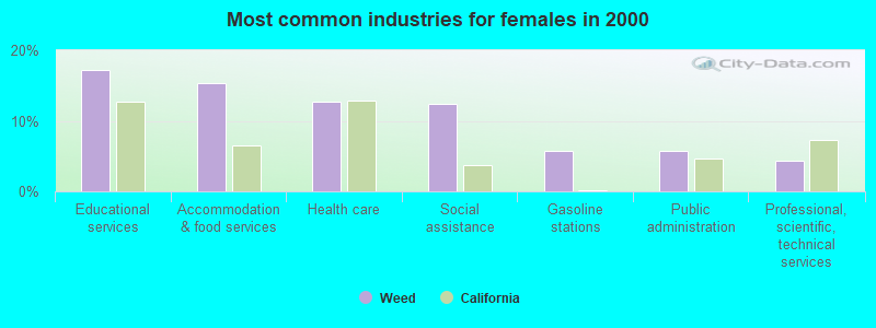
- Educational services (17.1%)
- Accommodation & food services (15.3%)
- Health care (12.7%)
- Social assistance (12.4%)
- Gasoline stations (5.7%)
- Public administration (5.7%)
- Professional, scientific, technical services (4.3%)
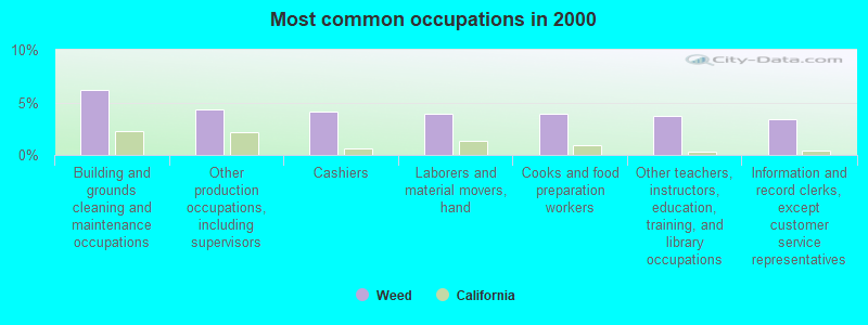
- Building and grounds cleaning and maintenance occupations (6.2%)
- Other production occupations, including supervisors (4.3%)
- Cashiers (4.1%)
- Laborers and material movers, hand (3.9%)
- Cooks and food preparation workers (3.9%)
- Other teachers, instructors, education, training, and library occupations (3.7%)
- Information and record clerks, except customer service representatives (3.4%)
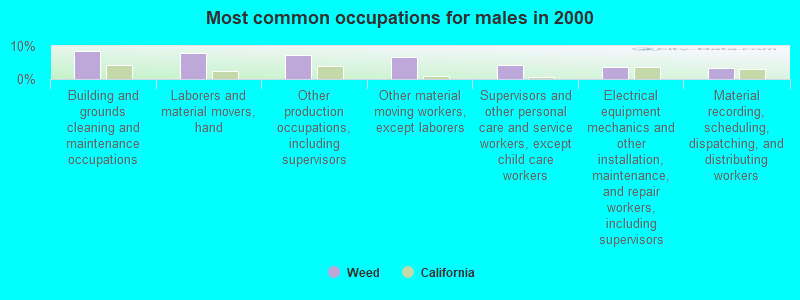
- Building and grounds cleaning and maintenance occupations (8.5%)
- Laborers and material movers, hand (7.7%)
- Other production occupations, including supervisors (7.1%)
- Other material moving workers, except laborers (6.5%)
- Supervisors and other personal care and service workers, except child care workers (4.2%)
- Electrical equipment mechanics and other installation, maintenance, and repair workers, including supervisors (3.8%)
- Material recording, scheduling, dispatching, and distributing workers (3.4%)
- Cashiers (7.6%)
- Other teachers, instructors, education, training, and library occupations (7.6%)
- Information and record clerks, except customer service representatives (5.9%)
- Cooks and food preparation workers (5.3%)
- Other office and administrative support workers, including supervisors (5.1%)
- Nursing, psychiatric, and home health aides (4.9%)
- Secretaries and administrative assistants (4.5%)
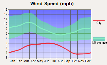
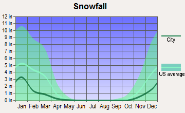
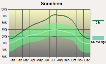
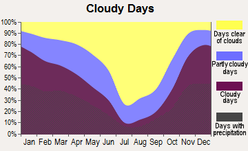
Average climate in Weed, California
Based on data reported by over 4,000 weather stations
|
|

(lower is better)
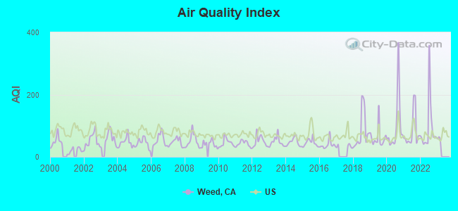
Air Quality Index (AQI) level in 2022 was 93.0. This is worse than average.
| City: | 93.0 |
| U.S.: | 72.6 |
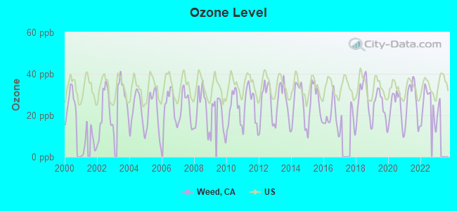
Ozone [ppb] level in 2022 was 25.2. This is better than average. Closest monitor was 24.6 miles away from the city center.
| City: | 25.2 |
| U.S.: | 33.3 |

Particulate Matter (PM2.5) [µg/m3] level in 2022 was 9.61. This is about average. Closest monitor was 24.6 miles away from the city center.
| City: | 9.61 |
| U.S.: | 8.11 |
Earthquake activity:
Weed-area historical earthquake activity is significantly above California state average. It is 4259% greater than the overall U.S. average.On 4/18/1906 at 13:12:21, a magnitude 7.9 (7.9 UK, Class: Major, Intensity: VIII - XII) earthquake occurred 239.1 miles away from Weed center, causing $524,000,000 total damage
On 1/31/1922 at 13:17:28, a magnitude 7.6 (7.6 UK) earthquake occurred 172.7 miles away from Weed center
On 11/8/1980 at 10:27:34, a magnitude 7.2 (6.2 MB, 7.2 MS, 7.2 MW, 7.0 ML) earthquake occurred 101.9 miles away from Weed center
On 4/25/1992 at 18:06:04, a magnitude 7.2 (6.3 MB, 7.1 MS, 7.2 MW, 7.1 MW, Depth: 9.4 mi) earthquake occurred 115.2 miles away from the city center, causing $75,000,000 total damage
On 1/22/1923 at 09:04:18, a magnitude 7.2 (7.2 UK) earthquake occurred 166.7 miles away from the city center
On 10/3/1915 at 06:52:48, a magnitude 7.6 (7.6 UK) earthquake occurred 263.0 miles away from the city center
Magnitude types: body-wave magnitude (MB), local magnitude (ML), surface-wave magnitude (MS), moment magnitude (MW)
Natural disasters:
The number of natural disasters in Siskiyou County (14) is near the US average (15).Major Disasters (Presidential) Declared: 8
Emergencies Declared: 2
Causes of natural disasters: Floods: 10, Storms: 5, Winter Storms: 5, Landslides: 3, Mudslides: 3, Drought: 1, Fire: 1, Heavy Rain: 1, Hurricane: 1, Other: 1 (Note: some incidents may be assigned to more than one category).
Hospitals and medical centers in Weed:
Airports located in Weed:
- Weed Airport (O46) (Runways: 1, Air Taxi Ops: 200, Itinerant Ops: 10,000, Local Ops: 6,000)
College/University in Weed:
Colleges/universities with over 2000 students nearest to Weed:
- Southern Oregon University (about 56 miles; Ashland, OR; Full-time enrollment: 4,650)
- Shasta College (about 56 miles; Redding, CA; FT enrollment: 5,645)
- Oregon Institute of Technology (about 66 miles; Klamath Falls, OR; FT enrollment: 2,900)
- Rogue Community College (about 86 miles; Grants Pass, OR; FT enrollment: 3,600)
- Humboldt State University (about 97 miles; Arcata, CA; FT enrollment: 7,353)
- College of the Redwoods (about 108 miles; Eureka, CA; FT enrollment: 4,410)
- California State University-Chico (about 121 miles; Chico, CA; FT enrollment: 14,838)
Public high school in Weed:
- WEED HIGH (Students: 138, Location: 909 HILLSIDE, Grades: 9-12)
Public elementary/middle schools in Weed:
- WEED ELEMENTARY (Students: 229, Location: 575 WHITE AVE., Grades: KG-8)
- WYEKA VISTA COMMUNITY DAY (Students: 9, Location: 720 S. DAVIS, APT. A, Grades: 1-8)
Private elementary/middle school in Weed:
Points of interest:
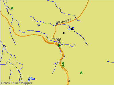
Notable locations in Weed: Weed Golf Club (A), Weed Museum (B), Weed City Hall (C), California Department of Forestry and Fire Protection Weed (D). Display/hide their locations on the map
Church in Weed: Calvary Chapel (A). Display/hide its location on the map
Cemetery: Winema Cemetery (1). Display/hide its location on the map
Lake: Summit Lake (A). Display/hide its location on the map
Parks in Weed include: Bel Air Park (1), Lincoln Park (2). Display/hide their locations on the map
Birthplace of: Mario Pastega - Philanthropist, Maurice A. Preston - Recipient of the Purple Heart medal, Pamela Courson - Girlfriend of the singer Jim Morrison, Will Sherman - Football player.
Drinking water stations with addresses in Weed and their reported violations in the past:
STEWART MINERAL SPRINGS (Address: 4617 Stewart Springs Road , Population served: 150, Groundwater):Past health violations:WEED GOLF CLUB, INC. (Population served: 110, Groundwater):Past monitoring violations:
- MCL, Monthly (TCR) - In AUG-2007, Contaminant: Coliform. Follow-up actions: St Public Notif requested (SEP-17-2007)
- One routine major monitoring violation
Past monitoring violations:TRAILER LANE RV PARK (Population served: 38, Groundwater):
- One routine major monitoring violation
Past monitoring violations:
- One routine major monitoring violation
| This city: | 2.5 people |
| California: | 2.9 people |
| This city: | 63.3% |
| Whole state: | 68.7% |
| This city: | 9.3% |
| Whole state: | 7.2% |
Likely homosexual households (counted as self-reported same-sex unmarried-partner households)
- Lesbian couples: 0.1% of all households
- Gay men: 0.1% of all households
46 people in nursing facilities/skilled-nursing facilities in 2010
79 people in college dormitories (includes college quarters off campus) in 2000
44 people in nursing homes in 2000
Banks with branches in Weed (2011 data):
- Scott Valley Bank: Weed Branch at 375 South Weed Boulevard, branch established on 1996/08/26. Info updated 2006/11/03: Bank assets: $477.2 mil, Deposits: $392.3 mil, headquarters in Yreka, CA, positive income, Commercial Lending Specialization, 13 total offices, Holding Company: Learner Financial Corporation
- Tri Counties Bank: Weed Branch at 303 Main Street, branch established on 1954/12/01. Info updated 2011/09/26: Bank assets: $2,554.4 mil, Deposits: $2,191.2 mil, headquarters in Chico, CA, positive income, Commercial Lending Specialization, 71 total offices, Holding Company: Trico Bancshares
- U.S. Bank National Association: Weed Branch at 269 Main Street, branch established on 1973/10/26. Info updated 2012/01/30: Bank assets: $330,470.8 mil, Deposits: $236,091.5 mil, headquarters in Cincinnati, OH, positive income, 3121 total offices, Holding Company: U.S. Bancorp
- PremierWest Bank: Weed Branch at 150 Alamo, branch established on 1984/03/21. Info updated 2011/05/20: Bank assets: $1,264.9 mil, Deposits: $1,128.9 mil, headquarters in Medford, OR, negative income in the last year, Commercial Lending Specialization, 46 total offices, Holding Company: Premierwest Bancorp
For population 15 years and over in Weed:
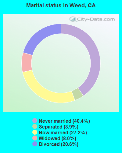
- Never married: 40.4%
- Now married: 27.2%
- Separated: 3.9%
- Widowed: 8.0%
- Divorced: 20.6%
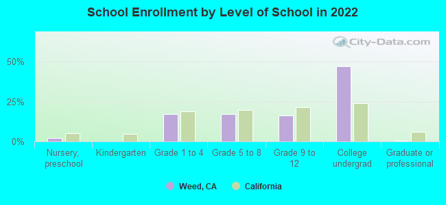
For population 25 years and over in Weed:
- High school or higher: 86.1%
- Bachelor's degree or higher: 12.5%
- Graduate or professional degree: 5.6%
- Unemployed: 18.5%
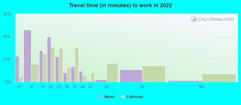
- Mean travel time to work (commute): 12.0 minutes

| Here: | 12.4 |
| California average: | 15.5 |
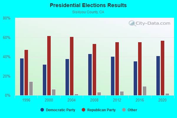
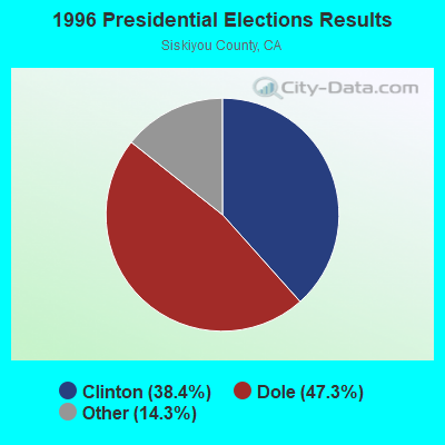
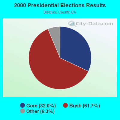
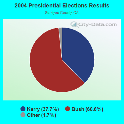
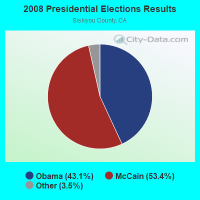
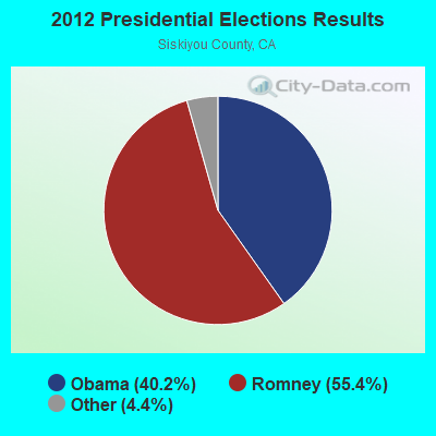
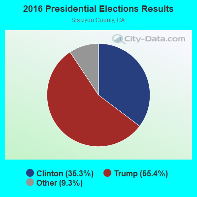
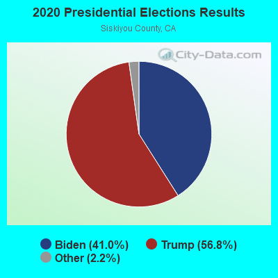
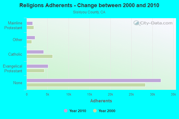
Graphs represent county-level data. Detailed 2008 Election Results
Religion statistics for Weed, CA (based on Siskiyou County data)
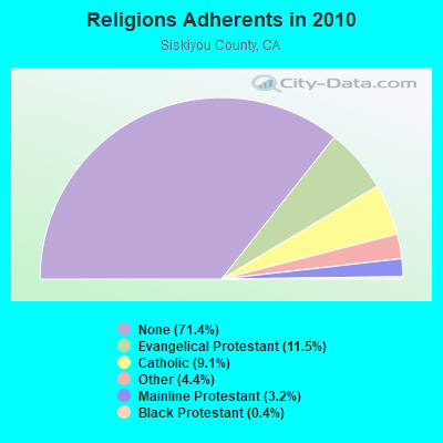
| Religion | Adherents | Congregations |
|---|---|---|
| Evangelical Protestant | 5,149 | 51 |
| Catholic | 4,089 | 12 |
| Other | 1,993 | 12 |
| Mainline Protestant | 1,444 | 16 |
| Black Protestant | 178 | 1 |
| Orthodox | - | - |
| None | 32,047 | - |
Food Environment Statistics:
| This county: | 4.75 / 10,000 pop. |
| California: | 2.14 / 10,000 pop. |
| This county: | 0.91 / 10,000 pop. |
| California: | 0.62 / 10,000 pop. |
| Siskiyou County: | 7.92 / 10,000 pop. |
| California: | 1.49 / 10,000 pop. |
| Siskiyou County: | 11.09 / 10,000 pop. |
| State: | 7.42 / 10,000 pop. |
| This county: | 8.3% |
| California: | 7.3% |
| This county: | 25.5% |
| State: | 21.3% |
| Siskiyou County: | 14.2% |
| California: | 17.9% |
Health and Nutrition:
| This city: | 47.5% |
| California: | 49.4% |
| Here: | 43.6% |
| California: | 48.0% |
| Weed: | 28.6 |
| California: | 28.1 |
| This city: | 22.5% |
| State: | 20.2% |
| Here: | 11.8% |
| State: | 11.2% |
| Weed: | 6.8 |
| State: | 6.8 |
| This city: | 33.3% |
| State: | 31.5% |
| Here: | 52.9% |
| California: | 56.4% |
| Here: | 77.2% |
| California: | 80.9% |
More about Health and Nutrition of Weed, CA Residents
| Local government employment and payroll (March 2022) | |||||
| Function | Full-time employees | Monthly full-time payroll | Average yearly full-time wage | Part-time employees | Monthly part-time payroll |
|---|---|---|---|---|---|
| Police Protection - Officers | 10 | $62,472 | $74,966 | 0 | $0 |
| Streets and Highways | 4 | $25,325 | $75,975 | 1 | $2,048 |
| Financial Administration | 3 | $17,674 | $70,696 | 0 | $0 |
| Police - Other | 3 | $12,827 | $51,308 | 3 | $3,375 |
| Other Government Administration | 2 | $19,953 | $119,718 | 0 | $0 |
| Other and Unallocable | 2 | $8,239 | $49,434 | 2 | $4,951 |
| Water Supply | 1 | $6,306 | $75,672 | 0 | $0 |
| Sewerage | 1 | $5,801 | $69,612 | 0 | $0 |
| Local Libraries | 0 | $0 | 2 | $3,408 | |
| Fire - Other | 0 | $0 | 1 | $3,138 | |
| Totals for Government | 26 | $158,598 | $73,199 | 9 | $16,919 |
Weed government finances - Expenditure in 2017 (per resident):
- Construction - Regular Highways: $242,000 ($86.09)
- Current Operations - Housing and Community Development: $1,634,000 ($581.29)
Police Protection: $1,448,000 ($515.12)
Central Staff Services: $824,000 ($293.13)
Sewerage: $768,000 ($273.21)
Local Fire Protection: $768,000 ($273.21)
Regular Highways: $713,000 ($253.65)
Water Utilities: $660,000 ($234.79)
Solid Waste Management: $513,000 ($182.50)
Financial Administration: $235,000 ($83.60)
Protective Inspection and Regulation - Other: $163,000 ($57.99)
Libraries: $45,000 ($16.01)
Health - Other: $1,000 ($0.36)
- General - Interest on Debt: $8,000 ($2.85)
- Other Capital Outlay - Local Fire Protection: $26,000 ($9.25)
Regular Highways: $24,000 ($8.54)
Sewerage: $17,000 ($6.05)
Water Utilities: $7,000 ($2.49)
Weed government finances - Revenue in 2017 (per resident):
- Charges - Sewerage: $751,000 ($267.16)
Solid Waste Management: $537,000 ($191.04)
Other: $112,000 ($39.84)
- Federal Intergovernmental - Housing and Community Development: $1,004,000 ($357.17)
Other: $164,000 ($58.34)
- Local Intergovernmental - Other: $2,000 ($0.71)
- Miscellaneous - General Revenue - Other: $310,000 ($110.28)
Donations From Private Sources: $32,000 ($11.38)
Fines and Forfeits: $13,000 ($4.62)
Rents: $5,000 ($1.78)
Interest Earnings: $1,000 ($0.36)
- Revenue - Water Utilities: $592,000 ($210.60)
- State Intergovernmental - Other: $1,457,000 ($518.32)
Highways: $99,000 ($35.22)
General Local Government Support: $6,000 ($2.13)
- Tax - General Sales and Gross Receipts: $1,248,000 ($443.97)
Property: $594,000 ($211.31)
Other Selective Sales: $420,000 ($149.41)
Public Utilities Sales: $83,000 ($29.53)
Other License: $44,000 ($15.65)
Occupation and Business License - Other: $12,000 ($4.27)
Documentary and Stock Transfer: $4,000 ($1.42)
Weed government finances - Debt in 2017 (per resident):
- Long Term Debt - Beginning Outstanding - Unspecified Public Purpose: $262,000 ($93.21)
Outstanding Unspecified Public Purpose: $188,000 ($66.88)
Retired Unspecified Public Purpose: $73,000 ($25.97)
Weed government finances - Cash and Securities in 2017 (per resident):
- Other Funds - Cash and Securities: $3,397,000 ($1208.47)
| Businesses in Weed, CA | ||||
| Name | Count | Name | Count | |
|---|---|---|---|---|
| Burger King | 1 | McDonald's | 1 | |
| Comfort Inn | 1 | Motel 6 | 1 | |
| Decora Cabinetry | 1 | Subway | 1 | |
| Lane Furniture | 1 | Taco Bell | 1 | |
| MasterBrand Cabinets | 3 | UPS | 1 | |
Strongest AM radio stations in Weed:
- KMJC (620 AM; 1 kW; MOUNT SHASTA, CA; Owner: JPR FOUNDATION INC.)
- KTMT (580 AM; 10 kW; ASHLAND, OR; Owner: MAPLETON COMMUNICATIONS, LLC)
- KAPL (1300 AM; 20 kW; PHOENIX, OR; Owner: APPLEGATE MEDIA, INC.)
- KGRV (700 AM; 25 kW; WINSTON, OR; Owner: PACIFIC CASCADE COMMUNICATIONS CORP.)
- KKOH (780 AM; 50 kW; RENO, NV; Owner: CITADEL BROADCASTING COMPANY)
- KNRO (1670 AM; 10 kW; REDDING, CA; Owner: REGENT LICENSEE OF REDDING, INC.)
- KRTA (610 AM; 5 kW; MEDFORD, OR; Owner: OPUS BROADCASTING SYSTEMS, INC.)
- KDUN (1030 AM; 50 kW; REEDSPORT, OR; Owner: PAMPLIN BROADCASTING-OREGON, INC.)
- KPNW (1120 AM; 50 kW; EUGENE, OR; Owner: CAPSTAR TX LIMITED PARTNERSHIP)
- KVIP (540 AM; 2 kW; REDDING, CA; Owner: PACIFIC CASCADE COMMUNICATIONS CORP.)
- KKJX (960 AM; 5 kW; KLAMATH FALLS, OR; Owner: NEW NORTHWEST BROADCASTERS, LLC)
- KCBS (740 AM; 50 kW; SAN FRANCISCO, CA; Owner: INFINITY BROADCASTING OPERATIONS, INC.)
- KAGO (1150 AM; 5 kW; KLAMATH FALLS, OR; Owner: NEW NORTHWEST BROADCASTERS, LLC)
Strongest FM radio stations in Weed:
- KNTK (102.3 FM; WEED, CA; Owner: FOUR RIVERS BROADCASTING, INC.)
- KNSQ (88.1 FM; MOUNT SHASTA, CA; Owner: STATE OF ORE./STATE BD. OF HGR. ED.)
- K235AG (94.9 FM; DORRIS, CA; Owner: CALVARY CHAPEL OF TWIN FALLS, INC.)
- K207BU (89.3 FM; YREKA, CA; Owner: SOUTHERN OREGON UNIVERSITY)
- KNYR (91.3 FM; YREKA, CA; Owner: STATE OF OREGON/STATE BD/OREGON STAT)
- KSYC-FM (103.9 FM; YREKA, CA; Owner: FOUR RIVERS BROACASTING, INC.)
- K214BS (90.7 FM; YREKA, CA; Owner: THE UNIVERSITY FOUNDATION)
- KMJC-FM (107.9 FM; MT. SHASTA, CA; Owner: EDUCATIONAL MEDIA FOUNDATION)
- K224AO (92.7 FM; WEED,ETC., CA; Owner: QUALITY CHRISTIAN MEDIA)
- K204DM (88.5 FM; YREKA, CA; Owner: CALVARY CHAPEL OF TWIN FALLS, INC.)
- KKRB (106.9 FM; KLAMATH FALLS, OR; Owner: WYNNE BROADCASTING COMPANY, INC.)
- KAKT (105.1 FM; PHOENIX, OR; Owner: MAPLETON COMMUNICATIONS, LLC)
- KTMT-FM (93.7 FM; MEDFORD, OR; Owner: MAPLETON COMMUNICATIONS, LLC)
- KHRD (103.1 FM; WEAVERVILLE, CA; Owner: RESULTS RADIO LICENSEE, LLC)
- KNCQ (97.3 FM; REDDING, CA; Owner: RESULTS RADIO OF REDDING, LLC)
- KNCA (89.7 FM; BURNEY, CA; Owner: OREGON STATE BOARD OF HIGHER ED.)
- KZRO (100.1 FM; DUNSMUIR, CA; Owner: BIG TREE COMMUNICATIONS)
- K225AJ (92.9 FM; BURNEY/REDDING, CA; Owner: CALVARY CHAPEL OF TWIN FALLS, INC.)
- KRRX (106.1 FM; BURNEY, CA; Owner: REGENT LICENSEE OF REDDING, INC.)
- KKLJ (88.9 FM; KLAMATH FALLS, OR; Owner: EDUCATIONAL MEDIA FOUNDATION)
TV broadcast stations around Weed:
- K33DI (Channel 33; EAST WEED, CA; Owner: CALIFORNIA BROADCASTING, INC.)
- K06GR (Channel 6; WEED, CA; Owner: NORTHERN CA.EDUCATIONAL TV ASS.,INC.)
- K27BH (Channel 27; LAKE SHASTINA, CA; Owner: CALIFORNIA BROADCASTING, INC.)
- National Bridge Inventory (NBI) Statistics
- 18Number of bridges
- 194ft / 59.4mTotal length
- 152,779Total average daily traffic
- 39,271Total average daily truck traffic

- New bridges - historical statistics
- 11940-1949
- 11960-1969
- 151970-1979
- 11980-1989
FCC Registered Antenna Towers: 69 (See the full list of FCC Registered Antenna Towers)
FCC Registered Broadcast Land Mobile Towers: 16 (See the full list of FCC Registered Broadcast Land Mobile Towers in Weed, CA)
FCC Registered Microwave Towers: 41 (See the full list of FCC Registered Microwave Towers in this town)
FCC Registered Amateur Radio Licenses: 79 (See the full list of FCC Registered Amateur Radio Licenses in Weed)
FAA Registered Aircraft: 9 (See the full list of FAA Registered Aircraft in Weed)
2005 - 2018 National Fire Incident Reporting System (NFIRS) incidents
- Fire incident types reported to NFIRS in Weed, CA
- 45048.3%Structure Fires
- 35037.6%Outside Fires
- 849.0%Mobile Property/Vehicle Fires
- 475.0%Other
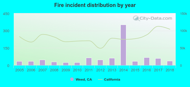 According to the data from the years 2005 - 2018 the average number of fires per year is 66. The highest number of fires - 353 took place in 2014, and the least - 25 in 2009. The data has a growing trend.
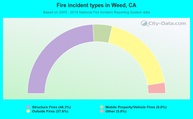 When looking into fire subcategories, the most reports belonged to: Structure Fires (48.3%), and Outside Fires (37.6%).
Fire-safe hotels and motels in Weed, California:
- Quality Inn & Suites, 1830 Black Buute Dr, Weed, California 96094 , Phone: (530) 938-1308, Fax: (530) 938-1349
- Comfort Inn, 1844 Shastina Dr, Weed, California 96094 , Phone: (530) 938-1982, Fax: (530) 938-1983
| Most common first names in Weed, CA among deceased individuals | ||
| Name | Count | Lived (average) |
|---|---|---|
| John | 48 | 74.2 years |
| Mary | 40 | 77.3 years |
| William | 30 | 74.1 years |
| Robert | 28 | 71.4 years |
| Frank | 25 | 77.1 years |
| James | 23 | 73.3 years |
| George | 19 | 79.0 years |
| Virginia | 13 | 76.9 years |
| Joseph | 12 | 75.2 years |
| Donald | 12 | 70.1 years |
| Most common last names in Weed, CA among deceased individuals | ||
| Last name | Count | Lived (average) |
|---|---|---|
| Smith | 26 | 76.2 years |
| Anderson | 12 | 75.4 years |
| Brown | 12 | 77.3 years |
| Williams | 10 | 68.9 years |
| Johnson | 9 | 78.8 years |
| Thomas | 8 | 75.6 years |
| Moore | 8 | 77.6 years |
| Jones | 8 | 79.4 years |
| Rossetto | 8 | 80.2 years |
| Wilson | 8 | 80.8 years |

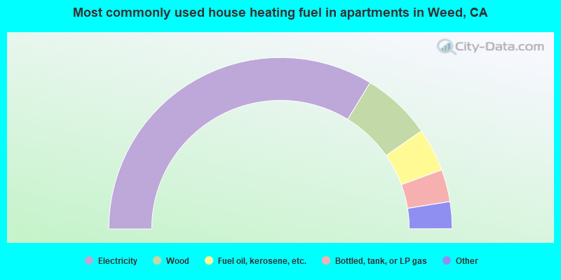
- 46.6%Wood
- 30.3%Fuel oil, kerosene, etc.
- 20.2%Electricity
- 1.9%Other fuel
- 1.0%Bottled, tank, or LP gas
- 67.7%Electricity
- 13.2%Wood
- 8.2%Fuel oil, kerosene, etc.
- 6.1%Bottled, tank, or LP gas
- 2.8%Utility gas
- 1.0%No fuel used
- 0.9%Other fuel
Weed compared to California state average:
- Median household income significantly below state average.
- Median house value significantly below state average.
- Hispanic race population percentage below state average.
- Foreign-born population percentage significantly below state average.
- Percentage of population with a bachelor's degree or higher below state average.

|
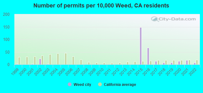
Total of 5 patent applications in 2008-2024.